


LIST OF TABLES
-
Table S-1 Comparison of Defense Program Activities for the Alternatives
Table S-2 Comparison of Waste Management Program Activities for the Alternatives
Table S-3 Comparison of Environmental Restoration Program Activities for the Alternatives
Table S-4 Comparison of Nondefense Research andDevelopment, Work for Others, and Site Support Activities forthe Alternatives
Table S-5 Summary of radioactivity on the NTS as of January 1996
Table S-6 Summary Comparison of Environmental Impacts of the Alternatives
Table S-7 Summary of Cumulative Impacts
Table 3-1. Comparison of Defense Program Activities for the Alternatives
Table 3-2. Comparison of Waste Management Program Activities for the Alternatives
Table 3-3. Comparison of Environmental Restoration Program Activities for the Alternatives
Table 3-4. Comparison of Nondefense Research and Development, Work for Others, and Site Support Activities for the Alternatives
Table 3-5. Summary Comparison of Environmental Impacts of the Alternatives
Table 4-1. Summary of radioactivity on the NTS as of January 1996
Table 4-2. Building space on the NTS
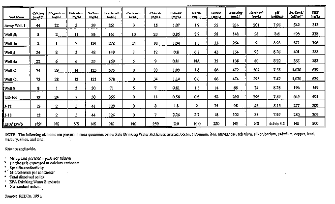
Table 4-3. Active water supply wells on the NTS
Table 4-4. Inactive water supply wells on the NTS
Table 4-5. Road transportation levels of service
Table 4-6. Traffic volumes and level of service on key roads
Table 4-7. Summary of economic indicators (by place of work), Clark and Nye Counties, Nevada, and the United States
Table 4-8. Workforce in Clark and Nye Counties
Table 4-9. 1990 civilian labor force, employment and unemployment, Clark and Nye Counties, Nevada, and the United States
Table 4-10. DOE/NV funding and employment, 1990 to 1994
Table 4-11. Population in the region of influence, 1990 through 1995
Table 4-12. 1990 housing characteristics in the region of influence
Table 4-13. Financial summary for Fiscal Year 1994, general, special revenues, debt service, and capital project funds, Clark County and Nye County jurisdictions
Table 4-14. Health care personnel in the region of influence (1995)
Table 4-15.Primary medical facilities serving the region of influence (1995)
Table 4-16. Flood regulations relevant to waste management and other facilities on the NTS and NAFR Complex
Table 4-17. Applicable flood events and other information regarding regulations listed in Table 4-16
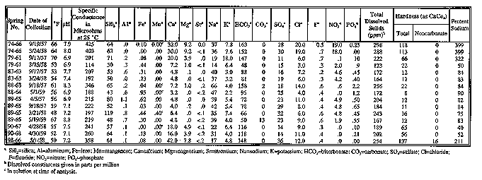
Tables 4-18. Chemical and radiochemical analyses of water from springs on the NTS
Table 4-19. Radioactivity in NTS surface waters
Table 4-20. NTS open reservoir gross beta analysis results
Table 4-21. NTS natural spring gross beta analysis results, 1993
Table 4-22. NTS containment pond gross beta analysis results
Table 4-23. Perennial yields and peak historic water demands for the 10 hydrographic basins on the NTS
Table 4-24. Major hydrogeologic units of the Death Valley flow system
Table 4-25. Summary of hydraulic properties of major hydrogeologic units
Table 4-26. Summary of 1993 water chemistry data for select wells on the NTS
Table 4-27. Remaining isotope inventory under or within 100 m (330 ft) of the water table
Table 4-28. Materials used in underground nuclear testing
Table 4-29. Summary of 1993 water well and discharge information for the NTS
Table 4-30. Species listed as endangered, threatened, or candidates under the Endangered Species Act that may be found in the areas addressed under the NTS, Tonopah Test Range, Central Nevada Test Area, Project Shoal Area, Dry Lake Valley, Eldorado Valley, and Coyote Spring Valleya
Table 4-31. Ambient air quality standards
Table 4-32. Maximum allowable pollutant concentration increases under Prevention of Significant Deterioration regulations
Table 4-33. Ambient air quality data for the NTS, 1990
Table 4-34. NTS source emission inventory, 1993
Table 4-35. NTS radioactive emissions - 1993, airborne effluent releases
Table 4-36. Summary of effective dose equivalents from NTS operations during 1993
Table 4-37. Types of site found within the hydrographic basins of the NTS
Table 4-38. American Indian traditional-use plants present in the NTS area
Table 4-39. American Indian traditional-use animals present at the NTS
Table 4-40. Water rights status for hydrographic basins at the Tonopah Test Range
Table 4-41. Types of sites found within the hydrographic basins of the Tonopah Test Range
Table 4-42. Background air quality data for the Dry Lake Valley
Table 5.1 Average on-site daily trip generation (one-way trips) by program, Alternative 1
Table 5.1-2 Average daily traffic volumes (one-way trips) on key NTS roadway segments, Alternative 1
Table 5.1-3 Average off-site daily vehicle trip generation, Alternative 1
Table 5.1-4 Peak-hour traffic volumes and level of service on key roads, Alternative 1
Table 5.1-5 Low-level volumes and shipments by generator sitea, Alternative 1
Table 5.1-6 Transportation risks, Alternative 1
Table 5.1-7 Economic activity projections, Clark and Nye counties, 1996, 1997, 1998, 2000, and 2005, Alternative 1
Table 5.1-8 Total housing projections for the region of influence, 1996, 1997, 1998, 2000, and 2005, Alternative 1
Table 5.1-9 Projected financial summary for Fiscal Years 2000 and 2005, general, special revenues, debt service, and capital projects funds, Alternative 1
Table 5.1-10 Projected levels of public service for Fiscal Years 1996, 2000, and 2005, Alternative 1
Table 5.1-11 Predicted (50th and 84th percentiles) peak ground motions at localities 30 km (19 mi) from underground testing areas
Table 5.1-12 Summary of NTS construction emissions and mobile source emissions (on site and off site), tons per year, Alternative 1
Table 5.1-13 Site-support activities stationary source emissions at the NTS and Nye County, tons per year, Alternative 1
Table 5.1-14 De minimis thresholds in nonattainment areas
Table 5.1-15 Health risks to workers and the public from program activities, NTS, Alternative 1
Table 5.1-16 Health risks to workers and the public from program activities, Tonopah Test Range, Alternative 1
Table 5.1-17 Health risks to workers and the public from program activities, Project Shoal Area, Alternative 1
Table 5.1-18 Health risks to workers and the public from program activities, Central Nevada Test Area, Alternative 1
Tabe 5.2-1 Average on-site daily trip generation (one-way trips) by program, under Alternative 2
Table 5.2-2 Average off-site daily vehicle trip reduction from Alternative 1, under Alternative 2
Table 5.2-3 Peak-hour traffic and level of service on key roads, under Alternative 2
Table 5.2-4 Economic activity effects for Clark and Nye counties in 1996, 1997, 1998, 2000, and 2005 totals for all programs, under Alternative 2
Table 5.2-5 Total housing projections for the region of influence, 1996, 1997, 1998, 2000, and 2005
Table 5.2-6 Projected financial summary for Fiscal Years 2000 and 2005, general, special revenues, debt service, and capital projects funds, under Alternative 2
Table 5.2-7 Projected levels of public service for 1996, 2000, and 2005, under Alternative 2
Table 5.2-8 Health risks to workers and the public from program activities, Nevada Test Site, Alternative 2
Table 5.2-9 Health risks to workers and the public from program activities, Tonopah Test Range, Alternative 2
Table 5.3-1 Average on-site daily trip generator (one-way trips) by program, Alternative 3
Table 5.3-2 Average daily traffic volumes on key NTS roadway segments under Alternative 3
Table 5.3-3 Average daily vehicle trip increase off site under Alternative 3
Table 5.3-4 Peak-hour traffic volumes and level of service on key off-site roads under Alternative 3
Table 5.3-5 Low-level waste volumes and shipments by generator sitea under Alternative 3
Table 5.3-6 Mixed waste volumes and shipments by generator sitea, Alternative 3
Table 5.3-7 Transportation risks under Alternative 3
Table 5.3-8 Economic activity effects for Clark and Nye counties 1996, 1997, 1998, 2000, and 2005, totals for all programs under Alternative 3
Table 5.3-9 Housing projections for the Nevada Test Site region of influence, 1996, 2000, and 2005, under Alternative 3
Table 5.3-10 Projected financial summary for fiscal years 2000 and 2005, general, special revenues, debt service, and capital projects funds under Alternative 3
Table 5.3-11 Projected levels of public service for the years of 1996, 2000, and 2005 under Alternative 3
Table 5.3-13 Site-support activities stationary emissions at the NTS and Nye
Table 5.3-16 Health risks to workers and the public from program activities, Nevada Test Site, Alternative 3
Table 5.3-17 Health risks to workers and the public from program activities, Tonopah Test Range, Alternative 3
Table 5.3-18 Health risks to workers and the public from program activities, Project Shoal Area, Alternative 3
Table 5.3-19 Health risks to workers and the public from program activities, Central Nevada Test Area, Alternative 3<
Table 5.4-1 Average on-site daily vehicle trip generation (one-way trips) by program, Alternative 4
Table 5.4-2 Average daily traffic volumes on key NTS roadway segments, Alternative 4
Table 5.4-3 Average off-site daily vehicle trip change, Alternative 4
Table 5.4-4 Peak-hour traffic volume and level of service on key roads, Alternative 4
Table 5.4-5 NTS-generated waste 10-year volumes
Table 5.4-6 On-site transportation risks from NTS-generated wastes, Alternative 4
Table 5.4-7 Economic activity effects for Clark and Nye Counties, 1996, 1997, 1998, 2000, and 2005 totals for all programs, Alternative 4
Table 5.4-8 Projected financial summary for Fiscal Years 2000 and 2005, general, special revenues, debt service, and capital projects funds, Alternative
Table 5.4-9 Summary of Nevada Test Site construction emissions and mobile source emissions (on site and off site), tons per year, Alternative 4
Table 5.4-10 Site support activities stationary source emission at the NTS and Nye County, tons per year, Alternative 4
Table 5.4-11 Health risks to workers and the public from program activities, Nevada Test Site, Alternative 4
Table 5.4-12 Health risks to workers and the public from program activities, Tonopah Test Range, Alternative 4
Table 5.4-13 Health risks to workers and the public from program activities, Project Shoal Area, Alternative 4
Table 5.4-14 Health risks to workers and the public from program activities, Central Nevada Test Area, Alternative 4
Table 6-1. Population projections
Table 6-2. Land area disturbed (acres)
Table 6-3. Cumulative transportation-related radiological collective doses and latent cancer fatalities (1951 to 2005)
Table 6-4. Cumulative socioeconomic impacts
Table 6-5. Summary of cumulative impacts
Table 8-1. Summary of meetings held on the NTS EIS and Transportation Study
Table A-1. Recent defense-related research and development projects conducted at the NTS
Table A-2. Utilities Table
Table A-3. Currently active or planned site-support projects
Table A-4. NTS EIS Program Summary Data and Resource Assumptions
Table E-1. Common and scientific names of plants and animals mentioned in text and tables
Table F-1. Estimated materials usage for the Big Explosives Experimental Facility operations
Table F-2. Estimated air emissions from detonation of high explosives at the Big Explosives Experimental Facility
Table F-3. Potential impacts from maximum potential exposure to tritium emissions
Table F-4. Maximum potential exposure to Big Explosives Experimental Facility-area workers
Table F-5. Comparison of annual Big Explosives Experimental Facility waste-generation rates with NTS waste-handling levels
Table G-1. American Indian traditional-use plants present at the NTS
Table G-2. American Indian tradiontion-use animals present at the NTS

|
NEWSLETTER
|
| Join the GlobalSecurity.org mailing list |
|
|
|