


AFFECTED ENVIRONMENTS
This chapter contains the description of the
existing environmental conditions of the Nevada Test Site (NTS), the Tonopah
Test Range, portions of the Nellis Air Force Range (NAFR) Complex, the Project
Shoal Area, the Central Nevada Test Area, Eldorado Valley, Dry Lake Valley, and
Coyote Spring Valley (Figure 4-1
).
During Environmental Impact Statement (EIS) preparation, the most up-to-date and
accurate information available was used to describe existing environments,
facilities, activities, and projects. The information serves as a baseline from
which to identify and evaluate environmental changes resulting from the proposed
alternatives. The baseline conditions, for the purposes of analysis, are the
conditions that currently exist. The regions of influence vary, as dictated by
the resources under consideration. For some discussions, such as site-support
activities, the regions of influence are limited to the areas circumscribed by
each U.S. Department of Energy (DOE) administrative boundary. For other topics,
such as transportation, groundwater, and air quality, the regions of influence
are much larger and may include all of southern Nevada, as well as portions of
Utah, Arizona, and California.
The environmental resources discussed in this chapter include land use,
geology and soils, hydrology, biology, air quality, noise, and visual and
cultural resources. Where applicable, this chapter also describes existing
waste management facilities and other resource elements, including airspace,
site-support activities, transportation, socioeconomics, occupational and public
health and safety, radiological conditions, and Environmental Justice.
The discussions of the DOE administrative units are organized according to
their relative geographic proximity to one another. Because the NTS and the
NAFR Complex share a boundary and because the units of interest are within 97 km
(60 mi) of each other, they are discussed together in the next section. The
Tonopah Test Range, Project Shoal Area, Central Nevada Test Area, Eldorado
Valley,Dry Lake Valley, and Coyote Spring Valley are discussed separately in
subsequent sections.
The existing environmental conditions of the NTS and portions of the NAFR
Complex are described in this section. The portion of the NAFR Complex that is
described is limited to Area 13.
The NTS, a unique national resource managed by the U.S. Department of
Energy, Nevada Operations Office (DOE/NV), is located about 105 km (65 mi)
northwest of Las Vegas. The
3,496 km
2
(
1,350 mi2) site features desert and
mountainous terrain and is larger than Rhode Island, making it one of the
largest secured areas in the United States. The NTS is in a remote and arid
region, surrounded by federal installations, with strictly controlled access,
and public lands that are open to public entry.
The following information pertaining to the NTS is provided by the American
Indian Writers Subgroup of the Consolidated Group of Tribes and Organizations
(CGTO). Information provided by the American Indians is italicized in this EIS
to distinguish it from DOE text.
For many centuries, the NTS has been a central place in the
lives of American Indian tribes. The NTS and nearby lands contain
traditional gathering, ceremonial, and recreational areas for the
American Indian people. From antiquity to contemporary times, this area
has been used continuously by many tribes. It contains numerous ceremonial
resources and power places that are crucial for the continuation of
American Indian culture, religion, and society. Until the mid-1900s,
traditional festivals involving religious and secular activities
attracted American Indian people to the area from as far as San
Bernardino, California. Similarly, groups came to the area from
a broad region during the hunting season and used animaland plant
resources that were crucial for their survival and cultural practices.
Figure 4-1. NTS and selected areas of interest
Despite the loss of some traditional lands to pollution and
reduced access, the American Indian people have neither lost their ancestral
ties to nor have forgotten their cultural resources on the NTS. There
is continuity in the American Indian use of and broad cultural ties to
the NTS. American Indian people have cared for the NTS resources and
will continue to do so.
Land resources are important considerations for decisions regarding site
use. The land-use analysis determines if there is enough land available for the
proposed facilities and required buffers, and identifies conflicts between the
proposed project and existing or projected on- and off-site land use. These
analyses are necessary to determine whether public lands would be managed in a
manner consistent with existing and projected land uses. To make decisions with
respect to locating facilities at the NTS, the DOE must consider several issues,
particularly the constraints and opportunities related to land resources. These
include whether conflicts exist with the administrative framework and whether
adequate resources are available and viable.
The known land-use constraints and opportunities at the NTS are outlined in
this section and described throughout this chapter. Land-use constraints
include those features of the NTS, either natural or manmade, that preclude or
limit the future activities that can be conducted in a specific location or
area. Opportunities are the best and highest uses of the land that can be
accomplished within the constraints. Further definition of land-use
opportunities and constraints is planned as part of the Framework for the
Resource Management Plan (see Volume 2).
Many of the constraints identified throughout Chapter 4 are those resulting
from historic land uses, primarily nuclear weapons, rocket and related nuclear
testing activities, and
to a lesser extent,
radioactive waste management activities. Many of these constraints on land use
were identified in the Final Environmental Impact Statement, NevadaTest
Site,
Nye County, Nevada (ERDA, 1977)
as unavoidable adverse impacts or irreversible actions with irretrievable
commitments of resources. Because of the nature of many historic activities and
their consequences, specifically the introduction of radionuclides into
environmental media, land use will continue to be constrained in some areas of
the NTS during the 10-year period covered by this EIS, and likely well into the
future. These constraints, and the specific environmental media that are
affected, are summarized at the end of this section.
Natural constraints, such as unstable soils or ecologically sensitive areas,
are described in the appropriate sections of Chapter 4 (i.e., Geology and Soils
and Biological Resources). Land-use opportunities under baseline (i.e.,
existing environmental and administrative) conditions are presented throughout
the remainder of Chapter 4, beginning in
Section 4.1.1.1
.
The remainder of this section summarizes the constraints to land use resulting
from the fulfillment of the DOE's missions at the NTS.
Based upon the more than 40 years of operations and information
gathered, many of the consequences of past weapons
testing and other activities are well understood and documented. Many of the
consequences described in this chapter were previously presented in the Final
Environmental Impact Statement, Nevada Test Site,
Nye County, Nevada (ERDA, 1977).
While not all of the consequences of historic actions at the NTS and adjacent
areas have been fully defined, this section presents an overview of their
resulting constraints and establishes a baseline of current conditions. The
baseline serves as a basis for evaluating the potential impacts of future
actions. Because of the complexity of some issues, a full understanding that
removes all uncertainty may never be achieved. Nonetheless, the DOE continues,
through many of the programs and actions described in this EIS, to address the
remaining data deficiencies and uncertainties.
For purposes of discussion, the past activities at the NTS have been grouped
into eight categories. In this section, a brief historical overview is
provided, and the known consequences and resultingconstraints on use of the
physical environment are presented.
Eight historic activities, and their consequences, are included in the
baseline discussion within this chapter:
Atmospheric Weapons TestingA total of 100 atmospheric
detonations were conducted before the Limited Test Ban Treaty was signed in
August 1963. Atmospheric tests include tests conducted at ground level, from
towers or balloons, or by airdrops.
Of the 100
atmospheric tests, 16 were safety tests. By design, these safety tests produced
little or no nuclear yield.
Underground Nuclear TestingApproximately 800 underground
nuclear tests have been conducted at the NTS. The types of tests conducted
include deep underground tests used to study weapons effects, designs, safety,
and reliability, and shallow borehole tests used to study the peaceful
application of nuclear devices for cratering.
The 70
underground safety tests conducted
on the
NTS, by design, produced little or no nuclear yield.
Safety TestsBetween late 1954 and June 1963, 16 tests were
conducted
aboveground to test the
vulnerability of certain weapon designs to possible
accidents. At a location in Area 5, 24 experiments, utilizing relatively small
quantities of plutonium, were conducted between 1954 and 1956. These
experiments, known as the GMX Project, were so-called "equation-of-state"
studies where "instantaneous" changes in the physical properties of
plutonium materials subjected to detonations from conventional explosives were
measured. By design, these experiments produced little or no nuclear yield.
Safety tests are no longer conducted aboveground; all such tests are
performed underground in emplacements that are designed so that radioactive
materials will not reach aboveground environments (AEC, 1972; AEC, 1973a; ERDA,
1976; ERDA, 1977). Impacts to soils that resulted from these historic
activities are described further in Chapter 4,
Section
4.1.4.3.
Nuclear Rocket Development StationTwenty-six experimental
tests of reactors, nuclear engines, ramjets, and nuclear furnaces were conducted
between 1959 and 1973.
Shallow Land Radioactive Waste Disposal Some wastes generated
during the testing program, and as a result of nuclear projects, were disposed
of in shallow cells, pits, and trenches. Because of the site's characteristics,
notably the absence of a groundwater pathway, shallow burial continues to be an
important waste disposal activity.
Crater DisposalContaminated soils and equipment collected
during the decontamination of atmospheric testing areas and the consolidation of
radioactively contaminated structures, and other bulk wastes, were disposed of
in subsidence craters in Yucca Flat.
Greater Confinement DisposalIn 1981, greater confinement
disposal of waste was initiated at Area 5 for certain radioactive low-level
wastes not suitable for shallow land disposal.
Site-SupportLike any large facility, the NTS
has a large infrastructure that provides all site-support services. Food and
housing services, paint shops, vehicle maintenance facilities, machine shops,
road maintenance, and other on-site facilities all produce more common
short-term impacts, such as localized land disturbance, air emissions, and
noise. Site-support facilities are associated with NTS land-use opportunities.
Table 4-1
and
Figure 4-2
provide information on the
key characteristics of the historic activities that have occurred on the NTS and
now constrain the future use of certain NTS land areas.
Figure 4-2
summarizes the historical
activities and identifies the media of concern in the physical environment that
could constrain their future use.
Table 4-1
lists
information on the nature of the source, the type of area involved, the media
affected, the principal contaminants, the depth, and the best available estimate
of the remaining inventory of radioactivity. It should be noted that in some
cases only approximate values are available; these values are presented solely
to illustrate the general characteristics of each source group and to highlight
the differences between the groups.
More detailed information for each affected resource is included in the
specific resource discussions in this chapter.
Section
4.1.1.5,
Waste Management Program, describes the existing waste management
operations at the NTS, including the locations, types of materials managed, and
the quantities of radioactive and nonradioactive wastes that have been disposed.
Section 4.1.2.3,
Transportation of Materials and
Wastes, identifies the out-of-state waste generators that ship low-level waste
to the NTS for disposal.
In
Section 4.1.4.2
, the baseline
geological conditions are described. The geology
baseline documents the physical disturbances to the subsurface environment that
have resulted from 35 years of underground nuclear testing.
Section 4.1.4.3
, Soils, identifies the
historical activities, such as atmospheric nuclear testing, safety tests, and
nuclear rocket and reactor experiments that have resulted in contamination of
surface soils. The extent and degree of contamination is also explained.
The NTS encompasses 3,496 km
2
(1,350 mi
2) of land area reserved to the jurisdiction of the DOE.
Figure 4-3
shows the land area as it has been
withdrawn through all forms of appropriation under the public land laws,
including mining and mineral-leasing laws through the public land orders and a
Memorandum of Understanding. Under Public Land Order 805 (February 12, 1952),
approximately 435,000 acres of land were reserved for use by the Atomic Energy
Commission as a weapons testing site. Under Public Land Order 1662 (June 20,
1958), 38,400 acres were reserved for the use of the Atomic Energy Commission in
connection with the NTS.
The lands described under this
Public Land Order are not considered in any alternative use by the
DOE and are, therefore, not addressed in this EIS.
Under Public Land Order 2568 (December 19, 1961), 318,000 acres of land
previously reserved for use by the U.S. Air Force were transferred to the
jurisdiction of the Atomic Energy Commission for use in connection with the NTS
for test facilities,roads, utilities, and safety distances. Under Public Land
Order 3759 (August 3, 1965), 21,108 acres of land were reserved for the
jurisdiction of the Atomic Energy Commission for use in connection with the NTS.
Pahute Mesa, located in the northern portions of Areas 19 and 20, which
encompasses 106,240 acres, is managed by the DOE as a part of the NTS in
accordance with a 1963 Memorandum of Understanding with the U.S. Air Force.
This memorandum was superseded by a Memorandum of Understanding between the U.S.
Air Force and DOE/NV in 1982 (DoD, 1982).
In 1983, the U.S. Bureau of Land Management, in accordance with the Federal
Land Policy and Management Act of 1976, conducted a review of the existing four
land withdrawals that comprise the NTS. The U.S. Bureau of Land Management
District Manager concurred with the review's conclusion that the lands were
still being used for the purpose for which they were withdrawn. Furthermore,
in recognition of a potential end of testing in
future years, the U.S. Bureau of Land Management recommended that the land
withdrawals again be reviewed in 100 years.
The NTS is located in Nye County in southern Nevada; its southernmost point is located
about 105 km (65 mi) northwest of Las Vegas, Nevada. The site varies from 46 to
56 km (28 to 35 mi) in width and 64 to 88 km (40 to 55 mi) in length (north to
south).
The DOE is in the process of developing a Resource Management
Plan. The goal of the Resource Management Plan will be to
establish a process for managing the facilities and national resources of the
NTS to ensure long-term diversity and productivity of natural ecosystems and
sustain the use of land and facilities at the NTS. The DOE will use this
process to evaluate the selection, design, and location of existing and proposed
activities. This process will identify the criteria for evaluating the
compatibility of these activities with public values, ongoing missions, existing
infrastructure, cultural and natural resources, human health and safety, and
other resources and land-use constraints on the NTS.
Table 4-1. Summary of radioactivity on the NTS as of January 1996
|
Source of Radioactivity |
Type of Area |
Environmental
Media |
Major Known Isotopes or Wastes |
Depth Range |
Amount (curies) |
| Atmospheric & Tower Tests |
Above Ground Nuclear Weapon Proving Area |
Surficial Soils & Test Structures |
Americium
Cesium
Cobalt
Plutonium
Europium
Strontium |
At Land Surface |
Approximately 20 |
| Safety
Tests |
Above Ground Experimental Areas |
Surficial Soils |
Americium
Cesium
Cobalt
Plutonium
Strontium |
Less than 0.9 m (3 ft) |
Approximately 35 |
| Nuclear Rocket Development
Area |
Nuclear Rocket Motor, Reactor, & Furnace Testing Area |
Surficial Soils |
Cesium
Strontium |
Less than 3 m (10 ft) |
Approximately 1 |
| Shallow Borehole Tests |
Underground Nuclear Testing Areas |
Soils & Alluvium |
Americium
Cesium
Cobalt
Europium
Plutonium
Strontium |
Less than 61 m (200 ft) |
Approximately 2,000 at land surface; unknown at depth |
| Shallow Land Disposal |
Waste Disposal Landfills |
Soils & Alluvium |
Dry Packaged Low-level & Mixed Wastes |
Less than 9 m (30 ft) |
Approximately 500,000a |
| Crater Disposal |
Test induced subsidence crater with sidewalls, cover, & drainage |
Soils & Alluvium |
Bulk contaminated soils & equipment |
Less than 30 m (100 ft) |
Approximately 1,250a (Approximately 205,000 m3
[7,250,000 ft3])b |
| Greater Confinement Disposal |
Monitored Underground Waste Disposal Borehole |
Soils & Alluvium |
Tritium
Americium |
37 m (120 ft) |
Approximately 9.3 milliona (Approximately 300 m3
[10,000 ft3])b |
| Deep Underground Tests |
Underground Nuclear Testing Areas |
Soils, Alluvium, & Consolidated Rock |
Tritium,
fission, &
activation products |
Typically less than 640 m (2,100 ft), but may be deeper |
Greater than 300 million |
| a Inventory at time of disposal (not corrected for
decay)
b Amount of waste that was considered for inventory. |
Existing land use on the NTS is divided into two site categories and
seven zone categories. The site and zone category
definitions are as follows:
Industrial, Research, and Support SiteAn industrial site is
used for the manufacturing, processing, and/or fabrication of articles,
substances, or commodities. A research site is usedfor projects to verify
theories or concepts under controlled conditions. Support sites are used for
office space, training,
equipment storage,
maintenance, security, feeding and housing, fire protection services, and health
services.
Waste Management SiteA site used
for the disposal, storage, and/or treatment of wastes.
Figure 4-2. Types and depth horizons of radioactivity
that remains on the NTS
Figure 4-3. NTS land withdrawals and Memorandum of Understanding
Nuclear Test ZoneLand area reserved for underground
hydrodynamic tests, dynamic experiments, and underground nuclear weapons and
weapons effects tests.
The stockpile stewardship
emplacement hole inventory is located within this zone (Appendix A,
Figure A-1
).
Nuclear and High Explosive Test ZoneLand area designated
within the Nuclear Test Zone for additional underground and aboveground
high-explosive tests or experiments.
Research, Test, and Experiment ZoneLand area designated for
small-scale research, development projects, pilot projects, and outdoor tests
and experiments for the development, quality assurance, or reliability of
materials and equipment under controlled conditions.
Radioactive Waste Management ZoneLand area designated for the
shallow land burial of low-level and mixed wastes.
Critical Assembly ZoneLand area used for conducting nuclear
explosive operations. Operations generally include assembly, disassembly or
modification, staging, repair, retrofit, and surveillance. The potential for
weapons storage also exists in this zone.
Spill Test Facility Impact ZoneA downwind geographic area that
would confine the impacts of the largest planned tests of materials released at
the Spill Test Facility.
Reserved ZoneControlled-access land area that provides a
buffer between nondefense research, development, and testing activities. The
Reserved Zone includes areas and facilities that provide widespread flexible
support for diverse short-term nondefense research, testing, and
experimentation. This land area is also used for short-duration exercises and
training, such as Nuclear Emergency Search Team and Federal Radiological
Monitoring and Assessment Center training, and U.S. Department of Defense (DoD)
land navigation exercises and training.
To simplify the distribution, use, and control of resources, the NTS is also
divided into numberedareas. The following pages contain an area-by-area
description of land use on the NTS. Refer to
Chapter 3
, Figure 3-1.
Area 1As a part of the Nuclear Test Zone, this
area occupies 70 km
2 (27 mi
2) near the center of the
Yucca Flat weapons test basin. Four atmospheric nuclear tests were conducted
here between 1952 and 1955. Three underground nuclear tests have also been
detonated in Area 1, one in 1971 and two in 1990.
Buildings and structures
associated with above-ground nuclear testing are
discussed in Section 4.1.10
and listed in Table
4-37 as NT (Nuclear Testing). Although many of these structures
are believed to be eligible, no official evaluation or
determination of eligibility has been conducted. Should any of these
structures be affected by project activities, an
evaluation would be completed, eligibility determined, and consultation with the
Nevada State Historic Preservation Office (SHPO) would be conducted prior to
initialing the project. The project would be conducted in accordance with SHPO
recommendations.
The Lyner Complex is a mined underground complex in Area 1 that is available
for dynamic experiments
(including subcritical
experiments involving special nuclear material) and hydrodynamic tests
that cannot be conducted aboveground because they may contain hazardous
materials.
Initial work on what is now known as the
Lyner Complex began in the late 1960s with the mining of the U1a shaft to a
depth of 305 meters (m) (1,000 feet [ft]) for a nuclear test. It was not used.
Further work took place in the 1980s and early 1990s to develop a complex that
could be used to perform intentionally designed low-yield tests or experiments,
which included safety tests, and other experiments that would be expected to
remain subcritical or produce negligible nuclear energy release. The Ledoux
nuclear test with a yield of less than 25 kilotons was conducted in 1990 in a
drift within this tunnel complex. The Kismet experiment, involving high
explosives, tritium, depleted uranium, and other materials, was a dynamic
experiment conducted in the Lyner Complex in March 1995. Both Ledoux and
Kismetwere contained to prevent radiological releases to the rest of the Lyner
Complex and the surface environment.
The Area 1 Industrial Complex, at the intersection of Pahute Mesa Road and
Tippipah Highway, is the maintenance and storage area for an over $20-million
inventory of large-hole drilling equipment and miscellaneous supplies. Typical
day-to-day operations include replacing worn cutters on a drill bit with new or
rebuilt cutters, straightening drill pipe and tubing, and other drilling tool
maintenance tasks. A concrete batch plant and storage area for bulk
construction material, as well as a shaker plant that produces stemming material
and concrete aggregate, lie to the north of the drilling yard.
There is one stockpile stewardship emplacement hole within Area 1 (Appendix
A,
Figure A-1
).
Area 2This area, within the Nuclear Test Zone,
occupies approximately 52 km
2 (20 mi
2) in the northern
half of the Yucca Flat basin. The eastern portion of Area 2 was the site of
seven atmospheric nuclear tests conducted between 1952 and 1957. The first in a
series of underground nuclear tests in Area 2 took place in late 1962 and
continued through 1990. A number of the 137 underground tests detonated in Area
2 were simultaneous detonations of multiple devices in the same emplacement
hole; other underground tests involved the firing of two or more devices with
the devices in separate
emplacement holes.
There are eleven stockpile stewardship emplacement holes
within
Area 2 (Appendix A,
Figure A-1
).
Most of the structures that comprised a former construction base camp
(consisting generally of Butler buildings, Quonset huts, and trailers) have been
relocated to Area 6, and the facilities remaining in Area 2 are in the process
of being moved to other locations or are being scrapped.
Area 3This portion of the Nuclear Test Zone occupies 8
2 km
2 (32 mi
2) near the center
of the Yucca Flat weapons test basin and was the site of 17 atmospheric tests
conducted between 1952 and 1958. A total of 251 underground nuclear testswere
conducted in Area 3 from 1958 through 1992. This is the largest number of tests
of any of the NTS underground test areas. A number of these tests consisted of
simultaneous device detonations, and nearly all of these simultaneous tests
consisted of single devices in separate emplacement holes. Nine of the
underground nuclear tests in Area 3 were conducted in unstemmed holes to
minimize, but not eliminate, the release of radioactivity to the atmosphere.
These unique tests were carried out between mid-1957 and late 1958.
There are four stockpile stewardship emplacement holes
within Area 3 (Appendix A, Figure A-1
).
Bulk low-level waste is disposed of in selected Area 3 subsidence craters
that, collectively, comprise the Area 3 Radioactive Waste Management Site. This
activity commenced in the mid-1960s when the DOE began removing scrap tower
steel, vehicles, and other large objects that had been subjected to atmospheric
testing. From 1979 to 1990, large amounts of contaminated soil and other debris
from the NTS were added to the craters. There are seven disposal craters. Two
craters are in use, two are full and temporarily capped, and three are in
reserve for potential future use.
Area 4This area, within the Nuclear Test Zone, occupies 41 km
2
(16 mi
2) near the center of the Yucca Flat basin. Area 4 was the
site of five atmospheric nuclear tests conducted between 1952 and 1957. From
the mid-1970s through 1991, a total of 35 underground nuclear tests were
conducted in Area 4, mainly in the northeast corner. Two of these tests involved
the simultaneous detonation of multiple devices in the same emplace ment hole.
The Big Explosives Experimental Facility in Area 4 is being evaluated for
its suitability as an operational complex for testing large charges of
conventional high explosives. Comprised of two earth-covered, steel-reinforced
concrete structures, one structure may serve as a manned operational control
room facility, and the other may serve as an unmanned camera room with viewing
ports to a gravel table where large charges of high explosives can be fired.
There are four stockpile stewardship emplacement holes in Area 4 (Appendix
A,
Figure A-1
).
Area 5This area, within the Reserved Zone, occupies some 246
km
2 (95 mi
2) in the southeastern portion of the site and
includes the Area 5 Radioactive Waste Management Site, the Hazardous Waste
Storage
Unit, and the Spill Test Facility.
From 1951 through early 1962, 14 atmospheric tests were conducted at
Frenchman Flat, several of which were weapons effects tests. Among the remains
of the structures tested in Frenchman Flat are simulated motel complexes, metal
frames that supported a variety of roofing materials, a window test structure,
cylindrical liquid storage vessels, reinforced concrete domes and aluminum
domes, bridge pedestals, and a bank vault; all of these remains are of
considerable historical interest. Five nuclear weapons tests were conducted
underground at Frenchman Flat between 1965 and 1968. However, the presence of
the carbonate aquifer makes this area less suitable for underground testing than
other locations on the NTS.
In the GMX area, 24 experiments, some utilizing
relatively small quantities of fissile materials, were conducted between 1954
and 1956. These experiments were so-called "equation-of-state"
studies where "instantaneous" changes in the physical properties of
plutonium materials subjected to detonations from conventional explosives were
measured. These experiments were conducted on or very near one place, and the
source can be considered to be at one site.
The Area 5 Radioactive Waste Management Site is located in a 732-acre
Radioactive Waste Management Zone used for low-level waste disposal. Mixed
waste, including transuranic mixed waste, has been disposed of at the site in
the past, and transuranic wastes are currently being stored there pending
disposal at the Waste Isolation Pilot Plant near Carlsbad, New Mexico. Disposal
of waste at the NTS is discussed in
Section 4.1.1.5
.
The Hazardous Waste Storage Unit is an accumulation point for nonradioactive
materials, such as paints, chemicals, unused or surplus fuels,and other items.
Periodically, all hazardous wastes generated at the NTS are sent to permitted
commercial facilities for recycling, incineration, or disposal.
The Spill Test Facility is a complex of fuel tanks, spill pads,
meteorological and camera towers, equipment and control buildings, and a wind
tunnel used for releasing hazardous materials and measuring their behavior in
outdoor conditions.
Area 6This area occupies 212 km
2 (82 mi
2)
between Yucca Flat and Frenchman Flat, straddling Frenchman Mountain. Only one
atmospheric nuclear test was conducted in Area 6, and that was in 1957. Between
1968 and mid-1990, five under ground nuclear tests were conducted at this
location, two of which involved the simultaneous detonation of multiple devices
in separate emplacement holes.
There are two stockpile stewardship emplacement holes
in Area 6 (Appendix A, Figure A-1
).
The Control Point complex serves as the command center, air operations
center, and timing and firing center for the Yucca Flat weapons test basin,
Frenchman Flat, Pahute Mesa, and surrounding areas. Augmenting facilities near
the secured compound include a communications building, several radiological
sciences and technical services buildings, a fire and first-aid station, and
various maintenance and warehouse structures.
The Area 6 Construction Facilities provide craft and logistical support to
activities in the forward areas of the NTS. This forward area complex replaces
older construction base camps in Areas 2 and 3. Those elements comprising the
Yucca Lake facilities include a variety of equipment storage facilities, a
heavy- duty maintenance and equipment repair facility, and decontamination
facilities. A 3,353 m (11,000 ft) airstrip and nearby weather station also are
located on the Yucca Lake bed.
The Device Assembly Facility, when open, will be the primary location of all
nuclear explosive operations at the NTS. Nuclear explosive operations include
assembly, disassembly or modification, staging, transportation, testing,
maintenance, repair, retrofit, and surveillance. TheDevice Assembly Facility
contains about 9,290 m
2 (100,000 ft
2) of interior floor
space within a Critical Assembly Zone composed of approximately 22 acres.
The Hydrocarbon Contaminated Soils Disposal Site is an existing, state of
Nevada-approved, Class III landfill. All non-Resource Conservation and Recovery
Act-regulated hydrocarbon contaminated soils and materials generated on the NTS
are disposed of at this landfill.
Area 7This area, within the Nuclear Test Zone, occupies 52 km
2
(20 mi
2 ) in the northeast quadrant of the Yucca Flat weapons test
basin. Twenty-six atmospheric tests were conducted in this area. From late
1964 through the fall of 1991, a total of 62 underground nuclear tests were
carried out in Area 7, all consisting of a single nuclear device in a drilled
emplacement hole.
There are three stockpile stewardship emplacement holes in Area 7 (Appendix
A,
Figure A-1
).
Area 8This area, within the Nuclear Test Zone, occupies 34 km
2
(13 mi
2) in the northeast quadrant of the Yucca Flat weapons test
basin. Area 8 was the site of three atmospheric nuclear tests conducted in
1958. From mid-1966 through late 1988, 10 underground nuclear tests were
carried out at this location. Two of the underground tests involved the
simultaneous firing of multiple devices put in the same emplacement hole.
Underground shelter structures were tested in the late 1950s, and in 1964 these
shelters were used by the University of Florida for shelter habitability
studies. Lawrence Livermore National Laboratory has conducted experiments in
this area.
Area 9This area, within the Nuclear Test Zone, occupies 52 km
2
(20 mi
2 ) in the northeast quadrant of the Yucca Flat weapons test
basin. Seventeen atmospheric tests were conducted in this area between 1951 and
1958. Area 9 has been used extensively for underground nuclear testing; 100
such tests were carried out from late 1961 to mid-1992. Of the dozen
underground tests involving the simultaneous detonation of multiple devices,
most involved the use of separateemplacement holes (two or more holes, each with
a single device).
There is one stockpile stewardship emplacement hole
in Area 9 (Appendix A, Figure A-1)
.
The Area 9 sanitary landfill is located in a subsidence crater formed as a
result of a subsurface nuclear detonation in the early 1960s. This Class II
landfill is allowed to receive all types of nonhazardous waste. In October
1995, the landfill underwent partial closure and will reopen as a Class III
construction and demolition debris landfill.
Area 10This area, incorporated in the Nuclear Test Zone,
occupies 54 km
2 (21 mi
2) in the northeast quadrant of
the Yucca Flat weapons test basin. Area 10 was the selected location for the
nation's first nuclear missile system test, an air-to-air rocket, detonated in
mid-1957. This was the only nuclear rocket test ever conducted at the NTS. Two
of the earliest shallow nuclear cratering experiments conducted at the NTS were
detonated in 1951 and 1955 at this location. Resuming with the deeply buried
Sedan cratering experiment in mid-1962 and extending through early 1991, a
number of underground nuclear tests were conducted in Area 10. Counting both
the cratering and contained underground tests, there were 57 nonatmospheric
nuclear tests. A number of the underground tests detonated in Area 10 were
simultaneous detonations of multiple devices in the same emplacement hole, while
others involved the firing of multiple devices, but with each of the nuclear
devices located in separate emplacement holes.
Area 10 is the site of Sedan Crater, which was formed by a thermonuclear
device detonated in July 1962. It left a large throw-out crater with a diameter
of 390 m (1,280 ft) and a depth of 98 m (320 ft). Sedan was the first in a
series of 23 Plowshare experiments conducted at the NTS to develop peaceful uses
of nuclear explosives. Sedan Crater is listed on the National Register of
Historic Places, a file of cultural resources of national, state, regional, or
local significance
identified by the National Park
Service. The Scooter Crater, also located in Area 10, is the result of a
500-ton conventional high-explosive experiment carried out in 1960.
Area 11This area,
which is split among
the Nuclear Test and Reserved Zones, occupies 67 km
2 (26 mi
2)
along the eastern border of the NTS. Four atmospheric plutonium-dispersal
safety tests were conducted in the northern portion of Area 11 in
1954 and 1956 in what is now known as Plutonium
Valley. Because of the radioactive residues that remain from the safety
experiments, Area 11 continues to be used on an intermittent basis for realistic
drills in radiological monitoring and sampling operations. In addition to the
aboveground safety tests, five underground nuclear weapons effects tests were
carried out in Area 11 between the spring of 1966 and early 1971.
An explosive ordnance disposal site is located in the southern portion of
Area 11. This is a Resource Conservation and Recovery Act permitted treatment
unit. The site consists of a detonation pit surrounded by an earthen pad,
approximately 8 m (25 ft) by
30 m (100 ft), and
supplemental equipment, which includes a bunker, electrical shot box, and
electrical wire. Typically, up to six detonations of 45 kilograms (kg) (100
pounds [lb]) or less of explosives are conducted annually.
Area 12This area, within the Nuclear or High Explosive Test
Zone, occupies 104 km
2 (40 mi
2) at the northern boundary
of the NTS known as Rainier Mesa. No atmospheric tests were conducted at this
location. Rainier Mesa was the site of the nation's first fully contained
underground nuclear detonation in the fall of 1957. Of the 61 underground
nuclear tests carried out in Area 12 between late 1957 and the fall of 1992,
only 2 were detonated in drilled holes, whereas all of the others were detonated
in mined tunnels.
Today, there are a number of tunnels mined into Rainier Mesa, within which
most DoD horizontal line-of-sight exposure experiments were conducted. In
particular, N-, P-, and T-Tunnel complexes were extensively developed during
the past several decades. N-Tunnel was also the location for a
non-proliferation experiment, detonated in September 1993; this experiment
involved 1.3 x 10
6 kg (2.9 x 10
6 lb) of conventional
high explosives. The DoD currently operates a high-explosives research and
development tunnel in Area 12. This reusable test bed supports
programsinvolving the detonation of conventional or prototype explosives and
munitions.
The Area 12 camp was used to support operations in the northern region of
the NTS. The camp includes housing and feeding facilities; other support
structures include a major maintenance building, various craft and repair shops,
a first-aid facility, and a supply depot. The camp is currently closed.
Area 13Officially, there is no Area 13 within the NTS
boundary; however, there is a land plot on the NAFR Complex, known as NAFR
Complex Area 13, which lies off the northeast corner of the NTS. This was the
location for a plutonium-dispersal safety experiment conducted in early 1957.
The only future DOE activities that
would occur in
this area would involve environmental restoration.
Area 14This Reserved Zone area occupies 67 km
2 (26
mi
2) in the south-central portion of the NTS. Relatively isolated
from the NTS's major operational and support facilities, no atmospheric or
underground nuclear tests have ever been conducted in Area 14.
Area 15This Reserved Zone area occupies 96 km
2 (37
mi
2) at the northeast corner of the NTS, and no atmospheric tests
were conducted at this location. However, between early 1962 to mid-1966, three
underground nuclear tests were carried out in Area 15.
Two major complexes are located in Area 15, the Hardhat/Piledriver site and
the U.S. Environmental Protection Agency (EPA) Farm Complex, both of which are
now closed. The Piledriver experiment in mid-1966 was one of the most complex
and expensive DoD underground nuclear tests ever carried out. The purpose of
these tests was to investigate the simulated effects of a nuclear surface
detonation on a deeply buried, superhard command and control center in a granite
rock formation.
From 1978 to 1983, the Spent Fuel Test, Climax was carried out in a
separately mined drift at the Hardhat/Piledriver site. The purpose of this
studywas to learn more about how granite would react to heat and radiation from
spent nuclear fuel.
As part of the nation's long-range health and safety program, an
experimental 30-acre dairy farm was developed and operated in Area 15 between
1965 and 1981. The purpose of this extensive research program was to study the
passage of airborne radionuclides through the soil-forage-cow-milk-food chain.
Area 16This area, within the Nuclear or High Explosive Test
Zone, occupies 7
3 km
2 (28 mi
2)
in the west-central portion of the NTS. No atmospheric tests have ever been
conducted at this location. Area 16 was established in 1961 for the DoD's
exclusive use in support of a complicated nuclear effects experiment that
required a tunnel location in an isolated area away from other active weapons
test areas. From mid-1962 through mid-1971, six underground nuclear weapons
effects tests (all in the same tunnel complex) were conducted at this location.
Currently, the DoD uses this area for high-explosives research and development
in support of programs involving the detonation of conventional or prototype
explosives and munitions.
Area 17This area, within the Reserved Zone, occupies 80 km
2
(31 mi
2) in the north-central portion of the NTS. This area has
been used primarily as a buffer between other testing activities. No
atmospheric tests or experimental activities of programmatic consequence have
been conducted in Area 17.
Area 18This area, within the Reserved Zone, occupies 231 km
2
(89 mi
2) in the northwest quadrant of the NTS. The inactive Pahute
airstrip is located in the east-central portion of the area. When in operational
status, the airstrip was primarily used for shipment of supplies and equipment
for Pahute Mesa test operations.
Area 18 was the site of
five nuclear weapons
tests:
four were conducted in mid-1962
and one underground test was conducted in 1964.
Two of these were atmospheric tests, two were cratering experiments, and one
was
a stemmed underground nuclear test. In 1964,
the Lawrence Livermore National Laboratory used the area for a
Plowshare-sponsored test using chemical high explosives to investigate the
potential use of nuclear explosives for ditch digging in dense hard rock.
Area 19This area, within the Nuclear Test Zone, occupies 388
km
2 (150 mi
2) in the northwest corner of the NTS. Area
19 was developed for high-yield underground nuclear tests. No atmospheric
nuclear tests were conducted in Area 19. From the mid-1960s through 1992, a
total of 35 underground nuclear tests were conducted.
There are five stockpile
stewardship emplacement
holes in Area 19 (Appendix A, Figure A-1
).
Area 20This area, within the Nuclear Test Zone, occupies 259
km
2 (100 mi
2) and is in the extreme northwest corner of
the NTS. Area 20, like Area 19, was developed in the mid-1960s as a suitable
location for high-yield underground nuclear tests. No atmospheric nuclear tests
were conducted in Area 20. Three underground nuclear tests in the megaton and
greater yield range were carried out on Pahute Mesa between 1966 and 1976.
These tests were the well-publicized Boxcar, Benham, and Handley events. From
the mid-1960s through 1992,
a total of 46
contained, underground nuclear tests were conducted in Area 20. All of these
Pahute Mesa tests have consisted of single nuclear devices being detonated in
drilled emplacement holes.
In addition to weapons development tests, one nuclear test detection
experiment and three Plowshare tests were conducted on Pahute Mesa. The
Plowshare tests in Area 20 included the nuclear cratering experiments Palanquin,
Cabriolet, and Schooner. Palanquin, detonated in the spring of 1965, was the
first nuclear test on Pahute Mesa.
There are two stockpile stewardship emplacement holes in Area 20 (Appendix
A,
Figure A-1
).
Area 21There is no Area 21 on the NTS.
Area 22This area, within the Reserved Zone, occupies 83 km
2
(32 mi
2) in the southeastern corner of the NTS and serves as the
main entrance area. Before 1958, this area included Camp Desert Rock, a Sixth
Army installation used for housing troopstaking part in military exercises at
the NTS. After 1958, the camp was essentially removed, with the exception of
the Desert Rock Airport. In 1969, the runway was extended to a length of 2,286
m (7,500 ft). The airport currently is open, but provides no services.
Area 23This area, within the Reserved Zone, occupies 13 km
2
(5 mi
2) in the southeastern portion of the NTS and is the location
of the largest operational support complex. Mercury was established in 1951 and
serves as the main administrative and industrial support center at the NTS.
Permanent structures and services include housing and feeding, laboratory,
maintenance, communication and support facilities, computer facilities,
warehouses, storage yards, motor pools, and administrative offices. Mercury is
located approximately 8 km (5 mi) from U.S. Highway 95.
The Area 23 Class II sanitary landfill, located just west of Mercury, is
open to receive all types of nonhazardous solid waste. Wastes are compacted and
covered to form layers. The Area 23 landfill receives approximately 830 tons of
solid waste annually. The landfill is an open, rectangular pit with steep,
nearly vertical sides. The current capacity of the landfill is approximately
4.5 x 10⁵ cubic meters (m
3)
(5.9 x 10⁵ cubic yards [yd³]).
Area 24There is no Area 24 on the NTS. However, Las Vegas and
North Las Vegas are sometimes referred to as Area 24.
Area 25This is the largest area on the NTS. It occupies some
578 km
2 (223 mi
2) in the southwestern corner of the site
and includes an entrance gate to the NTS.
Located roughly in the center of Area 25, Jackass Flats was the site
selected for a series of ground tests of reactors, engines, and rocket stages as
part of a program to develop nuclear reactors for use in the nation's space
program. In the early 1960s, the Atomic Energy Commission and the National
Aeronautics and Space Administration negotiated an interagency agreement to
establish and manage a test area at the NTS, designated as the Nuclear Rocket
Development Station. Thesefacilities, inactive since 1973, remain today in
various stages of disrepair. They consist of three widely separated reactor
test stands; two maintenance, assembly, and disassembly facility buildings; a
Control Point complex; an administrative area complex; and a radioactive
materials storage area.
Area 25
is divided into multiple zone
categories: Yucca Mountain Site Characterization Zone; Research, Test, and
Experiment Zone; and Reserved Zone. The Yucca Mountain Site Characterization
Zone within the boundaries of the NTS represents a land assignment area for site
characterization activities. The former Nuclear Rocket Development Station
administrative area complex in Area 25 has been rededicated as the Yucca
Mountain Site Characterization Central Support Site. Limited Yucca Mountain
characterization activities are also conducted off site and beyond Area 25.
Similarly, the NTS has monitoring activities off site. The Research, Test, and
Experiment Zone in Area 25 is used by the U.S. Army's Ballistic Research
Laboratory for depleted uranium testing. Two classifications of tests are
conducted under this program, open-air tests and X-tunnel tests. These tests
include hazard classification and system tests. Research sites within the
Reserved Zone include the Treatability Test Facility and Bare Reactor Experiment
Nevada (BREN) Tower. The Treatability Test Facility was established in Area 25
for bench-scale testing of physical processes for separating plutonium and
uranium from contaminated soils.
Area 25 was used in the early 1980s for MX (Peacekeeper) missile siting
studies and canister ejection certification tests.
The 465-m (1,527-ft) BREN Tower has been used intermittently by a number of
organizations to conduct sonic-boom research, meteorological studies, and
free-fall/gravity-drop tests. More recently, the facility has been used in
support of the Brilliant Pebbles program, as well as in studies to develop the
technology and measurement techniques for advanced infrared imaging from space
satellites. A Brilliant Pebble is a relatively small computer-operated,
rocket-powered vehicle that uses sensors and a small laser to detect andtrack an
oncoming ballistic missile, which the Brilliant Pebble vehicle is designed to
destroy by kinetic energy.
The Rock Valley Study Area, not shown on the map, is located south of
Jackass Flats Road on the southern boundary of Area 25. This location was
selected in 1960 for controlled studies relating to the effects of radiation on
a desert ecosystem. During the past three decades, these fenced study plots have
been used by a number of government-sponsored scientists, as well as students
and others conducting environmental research projects and experiments.
Portions of the Area 25 Reserved Zone are used by the military for land
navigation and training exercises.
Area 26This area, within the Reserved Zone, occupies 5
7 km
2 (22 mi
2) in the
south-central area of the NTS. The southern portions of this area were used in
the past for nuclear-powered ramjet engine tests known as Project Pluto. The
residual test facilities include a control point, test bunker, compressor house
and air-storage facilities, and a disassembly building.
Area 27This area, within the Critical Assembly Zone, occupies
130 km
2 (50 mi
2) in the south-central portion of the
NTS. Area 27's principal assembly facilities include five assembly bays, four
storage magazines, two combination assembly bay/storage magazines, and three
radiography buildings. The Area 27's critical assembly facilities are an
alternate to the Device Assembly Facility.
Area 27 was also used in the past for the Super Kukla
Reactor Facility.
Area 28No longer in existence, the Area 28 designation
formerly applied to a portion of the NTS that has since been absorbed into Areas
25 and 27.
Area 29This area, within the Reserved Zone, occupies 161 km
2
(62 mi
2) on the west-central border of the NTS. The site of a
communications repeater station for the NTS
is located in
the Shoshone Mountains.
Area 30This area, within the Reserved Zone, occupies 150 km
2
(58 mi
2) and, like Area 29, is on the western edge of the NTS. Area
30 also has fairly rugged terrain and includes the northern reaches of
Fortymile Canyon. In the past, Area 30 has had
limited use in support of the nation's nuclear testing programs, but in the
spring of 1968 it was the site of Project Buggy, the first nuclear row-charge
experiment in the Plowshare Program.
SURROUNDING LAND USEFigure 4-4
shows the status and use of lands around the NTS. The NTS is surrounded by
other federal lands. The NTS is bordered by the NAFR Complex on the north,
east, and west and by U.S. Bureau of Land Management lands on the south and
southwest.
Beyond the federal lands that surround the NTS, principal land uses in Nye
County in the vicinity of the NTS include mining, grazing, agriculture, and
recreation. Currently, Nye County does not have a land-zoning ordinance;
however, measures are being reviewed by the Board of Supervisors for approval.
Of the total land area within Nye County, only a small number of isolated areas
are under private ownership and, therefore, subject to general planning
guidelines. Urban and residential land uses occur beyond the immediate vicinity
of the NTS, in fertile valley regions such as the Owens and San Joaquin to the
west, the Virgin River to the east, Pahrump to the south, the Moapa River to the
southeast, and Hike and Alamo to the northeast. The nearest population centers
surrounding the NTS are Amargosa Valley, Indian Springs, Beatty, and Pahrump
Valley. These are all rural communities, with Amargosa Valley being the closest
to the NTS. Las Vegas is the closest major metropolitan area and is located
about 105 km (65 mi) southeast of the NTS. Amargosa Valley (formerly Lathrop
Wells) lies 3 km (2 mi) south of the NTS border.
Figure 4-4. NTS and surrounding land use
Clark County, to the southeast, consists of 20,
461
km² (7,900 mi²), of which about 95 percent is owned by the federal
government. The primary land uses of these federal lands include open grazing,
mining, and recreation. The remaining 5 percent of the land in Clark County is
used for state and local government, residential, industrial, and commercial
purposes. Numerous national, state, and local public recreation areas exist
within the region. Outdoor recreational areas include the Lake Mead National
Recreation Area, located 1
21 km (75 mi) east; the
Death Valley National Monument, located 19 km (12 mi) to the west-southwest; the
Red Rock National Conservation Area, located 64 km (40 mi) to the southwest; and
the Desert National Wildlife Range, located
5 km
(3 mi) east. Portions of the Desert National Wildlife Range overlap the NAFR
Complex and come within 3 km (2 mi) of the boundary of the NTS. State parks
include Spring Mountain Ranch State Park, located 80 km (50 mi) southwest, and
the Floyd R. Lamb State Park, located 72 km (45 mi) southwest. Other
recreational areas include year-round campsites and picnic areas in the Toiyabe
National Forest, located 40 km (25 mi) to the southwest. In addition, numerous
camping and fishing sites that are used during the spring, summer, and fall
months are located in the outlying areas north of the site.
The North Las Vegas Facility occupies approximately
80 acres in the city of North Las Vegas, Nevada. The North Las Vegas Facility
is zoned for general industrial use and is bordered on the north, south, and
east by general industrial zoning. The western border of the site is adjacent
to a street, which acts as a buffer zone, separating the site from
fully-developed, single family, residential-zoned property.
The North Las Vegas Facility is divided into three distinct areas. The
first area covers 20 acres and houses support for the Lawrence Livermore
National Laboratory test program. The second area covers 20 acres and houses
support for the Los Alamos National Laboratory test program. The third area
covers 38.3 acres and houses a computer center and administrative and
engineering support functions.
.
The following sections provide a brief discussion of the current NTS
site-support services (infrastructure). Additional details regarding site
support are provided in
Section A.6
of Appendix A.
FACILITIESThe NTS contains approximately 1,500 buildings that
provide approximately269,419 m
2 (2.9 x 10
6 ft
2)
of space. A breakdown of the types of facilities and their cumulative space is
given in
Table 4-2
. Many of these facilities have been
either mothballed or abandoned because of the reduction of program activities at
the NTS.
SERVICESServices available at the NTS include law enforcement
and security, fire protection, and health care.
Law Enforcement and SecurityLaw enforcement on the NTS is
provided by the Nye County Sheriff's Department through a substation located at
Mercury. Security enforcement is the responsibility of Wackenhut Services, Inc.
The NTS is a controlled-access area. Wackenhut Services, Inc., a private
contractor, provides sitewide protective services following guidelines
established by the DOE/NV Safeguards and Security Division.
The DOE currently contracts with the Nye County Sheriff's Department for
five officers at the NTS substation to assist in civilian law enforcement. There
is no holding facility at the NTS; most people arrested at the NTS are
transported to Pahrump. If the individual cannot pay bail, he is sent to
Tonopah, Nevada (Willen, 1995).
Security facilities at the main gate include a badging and security office.
Other facilities include firing ranges, an ammunition dump, a security training
facility, and an obstacle course. Mobile ground patrols provide security
throughout the site. Helicopters and light aircraft are used to check perimeter
barricades and other remote locations in the forward area. Teams of armed
guards are available to respond to emergency situations and to escort the
movement of nuclear explosives and special nuclear materials within the NTS.
Response teams are equipped with all-terrain, high-speed armored vehicles (
Raytheon Services Nevada, 1994b).
Fire ProtectionThe fire protection capacity of the NTS is
structured to accommodate current mission requirements, with a self-contained
fire-fighting department responsible for suppression and prevention. Other
services include rescue, hazardous material response, training of fire
personnel, fire prevention inspection, installation of all fire extinguishers at
the NTS, and fire prevention awareness programs (Raytheon Services Nevada,
1994).
Table 4-2. Building space on the NTS
|
Functional Unit |
Square Meters |
Square Feet |
| Administrative |
72,081 |
775,874 |
| Temporary Housing |
22,499 |
242,178 |
| Storage |
68,886 |
741,483 |
| Services |
62,667 |
674,539 |
| Research and Development |
38,215 |
411,338 |
| Reactor and Accelerator |
305 |
3,286 |
| Other Known Assets |
101 |
1,088 |
| Other Storage |
3,713 |
39,971 |
| Industrial/Production Process |
3,290 |
35,418 |
| Service Structures |
205 |
2,208 |
| Communication and Related Systems |
797 |
8,575 |
| Distribution Systems |
36 |
390 |
A fire department staffed with support-contractor personnel provides 24-hour
fire-fighting services for the NTS. In addition, fire protection and crash
rescue services are provided for two airstrips
, upon
request. Within site boundaries, the fire department provides support
during the transportation, transfer, and storage of toxic and flammable gases.
The fire department maintains
one fire
station in Mercury. Support equipment used by the fire
department include one engine company, one tanker truck, and one UNMOG used for
wildlands support (Raytheon Services Nevada, 1994).
Health CareAn eight-bed dispensary in Mercury serves as a
clinic for the NTS. Facilities include rooms for emergency care, examination
and treatment, X-ray, and associated darkroom equipment, as well as offices and
storage. The facility can respond rapidly to normal and emergency situations,
including in-patient treatment, emergency surgery, and radiation accidents.
First-aid stations are located near field activities so that personnel can
betreated quickly. Ambulances are available for emergencies that occur on the
site, in nearby communities, or on highways (
Raytheon
Services Nevada, 1994).
UTILITIESThe utilities at the NTS include water systems,
wastewater systems, and electrical systems.
Water SystemsThe NTS is presently served by a water system
consisting of
11 operating wells
for potable water, one well for non-potable water (
Table 4-3)
, 27 usable storage tanks, 13 usable construction
water sumps, and 6 water transmission systems (with 5 permitted water
distribution systems). The wells are not being used to their full capacity and
are capable of producing much more water if needed. Additional inactive wells
are available (
Table 4-4)
or wells may be drilled and
developed if increased water production is required. Wells, sumps, and storage
tanks are used, as required, to support construction or operational activities.
Five water storage tanks are currently under construction at the NTS. Domestic,
construction, and fire protection water are supplied by this system through over
161 km (100 mi) of supply line. Potable water is trucked to support facilities
that are not connected to the potable water system. The NTS used approximately
1.7 billion liters (L) (457 million gallons [gal]) of water in 1994. Mercury was
the primary user of this water, using 40 percent of the total water pumped. The
forward areas of the NTS used approximately
7.0 x 10⁸
L (1.9 x 10
8 gal).
Table 4-3. Active water supply wells on the NTS
|
Well* |
Water Service Areas |
Area Served |
Type |
Status |
Sumps & Reservoirs Storage Capacity |
Flow Rate
|
| L |
gal |
L/min |
gal/min |
| U-20a |
A |
19, 20 |
Nonpotable |
Active |
154,400,000 |
40,780,000 |
1,060 |
280 |
| 8 |
B |
2, 12 |
Potable |
Active |
2,100,000 |
553,000 |
2,045 |
540 |
| UE-16d |
B |
1 |
Potable |
Active |
None |
None |
735 |
194 |
| C |
C |
6, 3 |
Potable |
Active |
4,880,000 |
1,290,000 |
1,100 |
290 |
| C-1 |
C |
6, 3 |
Potable |
Active |
See Well C |
See Well C |
1,100 |
290 |
| 4 and 4a |
C |
6 |
Potable |
Active |
See Well C |
See Well C |
2,651 |
700 |
| 5b |
C |
5, 22, 23 |
Potable |
Active |
2,700,000 |
710,000 |
871 |
230 |
| 5c |
C |
5, 22, 23 |
Potable |
Active |
190,000 |
50,000 |
871 |
230 |
| J-12 |
D |
25 |
Potable |
Active |
13,510,000 |
3,555,000 |
2,878 |
760 |
| J-13 |
D |
25 |
Potable |
Active |
190,000 |
50,000 |
2,574 |
680 |
| Army Well 1 |
C |
22, 23 |
Potable |
Active |
None |
None |
371 |
98 |
| * The locations of these wells are shown on
Figure 4-5
. |
Table 4-4. Inactive water supply wells on the NTS
|
Wella |
Water Service Areas |
Area Served |
Type |
Status |
Sumps & Reservoirs Storage Capacity |
Flow Rate |
| L |
gal |
L/min |
gal/min |
| UE-19c |
A |
19, 20 |
Nonpotable |
Inactive |
13,984,000 |
2,900,000 |
1,363 |
360 |
| UE-15d |
B |
15 |
Nonpotable |
Inactive |
56,781 |
15,000 |
1,022 |
270 |
|
2 |
B |
2, 4, 7, 9, 10 |
Potable (chlorinator) |
Inactive
(pump failed) |
3,293,308 |
870,000 |
643 |
170 |
| UE-1r |
B |
1 |
Nonpotable |
Inactive |
None |
None |
1,022 |
270 |
|
UE-5c |
C |
5 |
Nonpotable |
Active for environmental sampling only |
None |
None |
1,325 |
350 |
| 5a |
C |
5 |
Potable |
Abandoned |
None |
None |
341 |
90 |
| F |
C |
27 |
Nonpotable |
Inactive |
None |
None |
901 |
238 |
| 3 |
C |
3 |
Nonpotable |
Inactive |
None |
None |
None |
None |
| J-11 |
D |
25 |
Potable |
Abandoned |
See Well J-12b |
See Well J-12b |
None |
None |
| a The locations of these wells are
shown on Figure 4-5
.
b Table 4-3.
|
For evaluation purposes, the NTS water system has been divided into four
water service areas (A, B, C, and D) according to the location of the water
system and support facilities (
Figure 4-5
).
Water service area A includes NTS Areas 19 and 20; service area B covers Areas
2, 4, 7, 8, 9, 10, 12, 15, 17, and 18; service area C supplies Areas 1, 3, 5, 6,
11, 22, 23, 26, and 27; and service area D supplies water to the remaining areas
of the NTS.
Non-potable water distribution in water service area A is through an
aboveground 152 millimeter (mm) (
6-inch [in.])
pipe line that runs along the Pahute Mesa
Road between
Well UE-19c, the Area 20 camp, and Well U-20a. Water in this system must
maintain a constant flow to prevent freezing in the extreme temperatures.
Water service area B has two
potable water distribution
systems to serve water needs in this area. The Area 17 support facilities are
supplied by the system from Well
UE-16d. The
other transmission system in this area feeds from Well 8 to the Area 12 camp
through
152-mm (6-in.) pipe line and 102-mm
(4-in.) pipe line and then into the Area 2 facilities through 152-mm (6-in.)
pipe line connecting to Well 2.
The two distribution systems in water service area C feed several wells and
use 203-mm (8-in.), 102-m (4-in.), and 152-mm (6-in.) underground pipelines. The
Area 6 distribution system is supplied by Wells 4, C, C1, and 4a, and provides
potable water service to the Device Assembly
Facility, the Yucca Lake facilities, the Control Point, and the Well 3 yard.
This system contains
segments of old asbestos
pipe. Area 5, Mercury, and Desert Rock facilities are supplied by a system
connecting Wells 5b, 5c, and Army Well 1.
Wells J-12 and J-13 supply
potable water to
the single transmission system in water service area D. This system (in NTS Area
25) supplies severalreservoirs and the former Nuclear Rocket Development Station
facilities through 152 mm (6-in.), 203-mm (8-in.), and
304-mm
(12-in.) pipe lines.
Wastewater SystemsWastewater on the NTS is disposed of either
by a combination septic tank and leach field system or by a lagoon system. At
areas not serviced by a permanent wastewater system, portable sanitary units are
provided. The size and type of wastewater systems used are determined by
anticipated discharge and cost effectiveness.
Electrical SystemElectric power is delivered to the NTS at the
Mercury switching center in Area 22 by a primary 138-kilovolt (kV) supply line
from the Nevada Power Company system near Las Vegas. A second Nevada Power
Company-owned 138-kV line connects the Mercury switching center to the Jackass
Flats substation in Area 25. Valley Electric Cooperative, serving the Pahrump,
Nevada area also has a transmission connection to the Jackass Flats substation.
The dual transmission and station connections provide the NTS with the ability
to receive service from either transmission source depending on contractual
arrangements. A DOE-owned 138-kV loop extends this primary power supply into
the NTS forward areas where smaller, lower-voltage distribution lines feed power
to individual facilities. During the last several years, the NTS has been
provided power under contracts with Nevada Power Company and the Western Area
Power Administration. Additionally, the DOE has periodically operated oil-fired
diesel generators at Area 25 for peak and back-up power supply purposes
(Raytheon Services Nevada, 1994).
Electric power on the NTS is carried over 426 km (265 mi) of transmission
and subtransmission lines (Raytheon Services Nevada, 1994). The power
subtransmission uses an extensive 34.5-kV system and two small 69-kV systems.
These systems provide distribution voltages of 4.16 kV and 12.47 kV at various
substations. Distribution voltages are transformed to both 480/277-volt and
208/120-volt three-phase systems for most NTS loads, with a few single-phase
120-volt services.
Figure 4-5. Existing water service areas and supply wells on the
NTS
Power transmission/subtransmission lines and substations located on the NTS
are shown on
Figure 4-6
.
COMMUNICATIONSCommunication systems cover not only the entire
area of the NTS, but also reach far beyond its boundaries. The NTS
telecommunications system employs digital telephone switching, fiber-optic
transmission, microwave, two-way radio, voice privacy, data transmission
systems, general- and special-purpose data communications, and teleconferencing
services (secure as necessary).
Communications support also includes automated data processing equipment,
automated office support systems, and information systems. Computer systems
encompass general purpose, stand alone, data management, word processing,
engineering, computer-aided drafting, and computer-aided manufacturing.
Airspace must be managed and used in a manner that best serves the competing needs of
commercial, general, and military aviation interests. The Federal Aviation
Administration is responsible for the overall management of airspace and has
established different airspace designations that are designed to protect
aircraft during flights to or from an airport, transiting between airports, or
operating within "special use" areas identified for defense-related
purposes. Rules of flight and air traffic control procedures have been
established to govern how aircraft must operate within each type of designated
airspace. All aircraft operate under either instrument flight rules or visual
flight rules.
The type and dimension of individual airspace areas established within a
given region and their spatial and procedural relationship to one another are
contingent upon the different aviation activities conducted in that region.
When any significant change
in airspace use is
planned for a region, the Federal Aviation Administration will reassess the
airspace configuration to determine if such changes will adversely affect (1)
air traffic control systems and/or facilities, (2) movement of other air
traffic in the area, or (3) airspace already designated and used for other
purposes (i.e., military operating areas or restricted areas).
Approximately 16,000 sortieswere flown on the Tonopah
Test Range by the DOE in Fiscal Year 1994. These sorties included employee
transportation and activities associated with Defense and Work for Others
Programs.
Airspace associated with the NTS and vicinity is shown on
Figure 4-7
. The NTS airspace is part of the
NAFR Complex, which includes 4 restricted areas, the desert military operating
areas/air traffic control assigned airspace, 2 low-altitude tactical navigation
areas, 29 military training routes, and 3 air refueling routes.
Greater detail of the airspace configuration is shown on
Figure 4-8
. Restricted area
R-4808 is the airspace over the NTS. Airspace
control over portions of the restricted areas and all desert military operating
areas has been delegated to the Nellis Air Traffic Control Facility by the
Federal Aviation Administration Air Route Traffic Control centers serving the
surrounding airspace. The Nellis Air Traffic Control Facility controls the
entry and exit of military aircraft in this airspace, while the Range Control
Center monitors mission activities within this airspace. Because activities in
restricted areas can be hazardous, nonparticipating aircraft are restricted from
this airspace except when released by the controlling agency for joint use. The
Nellis Air Traffic Control Facility may release and authorize use of R-4806 and
R-4807 for nonparticipating aircraft when
these areas are
not required for defense-related activities. Restricted areas R-4808 and
R-4809 are managed by the DOE and are never authorized for use by civilian
aircraft.
The desert military operating areas comprise the eastern half and northern
portion of the airspace associated with the NAFR Complex. The training
conducted within the desert military operating areas consists of high-speed
operations, including abrupt aircraft maneuvers and supersonic flight at or
above 1,524 m (5,000 ft) above ground level. Within the military operating
areas, military aircraft are exempted from the provisions of Federal Aviation
Regulation 91.71, which normally restrict abrupt aircraft maneuvers or
aerobatics within federal airways and control zones. The desert military
operating areas are active during daylight hours Monday through Saturday and at
other times by
authorization.
Figure 4-6. NTS sitewide power distribution
Figure 4-7. NTS and vicinity airspace
Figure 4-8. Detailed configuration of the NTS and vicinity airspace
Even though military aircraft are scheduled for flight activity within the
military operating areas, civilian aircraft flying under visual flight rules can
fly through the area. In addition, both military and civilian aircraft
operating under instrument flight rules may be cleared through the military
operating areas by Nellis Air Traffic Control Facility if in-flight separation
can be provided.
The low-altitude tactical navigation areas are unrestricted airspace used
intermittently by the military. These areas allow A-10 aircraft to practice
random tactical navigation and formations between
30 m
(100 ft) and
457 m (1,500 ft) above ground level
at airspeeds at or below 250 knots
(288 mi/hr).
These areas are normally used when no airspace is available for this type of
training within the NAFR Complex.
The military training routes and air refueling routes are located within or
at the boundaries of airspace associated with the NAFR Complex. Several of
these military training routes overlap or are reversals of each other.
Generally, military training routes are established below
3,048 m (10,000 ft) mean sea level for operations at speeds in excess of
250 knots
(288 mi/hr). However, some military
training route segments may be at higher altitudes because of terrain or climb
and descent requirements. There are instrument-flight-rule military training
routes and visual-flight-rule military training routes. The normal width of an
instrument-flight-rule military training route from the centerline is 8 km (5
mi) and 8 to 16 km (5 to 10 mi) for visual-flight-rule military training routes,
although some segments of these routes may be as narrow as 3 km (2 mi) and as
wide as 32 km (20 mi).
Figure 4-9
shows the
complexity of military training routes.
There are several other types of designated airspace around the NAFR
Complex/Las Vegas area. The following are brief descriptions of these types:
- Indian SpringsAir Force Auxiliary Airfield
Class D airspace encompasses a
8 km (5-statute mile) radius around the airfield
from the surface to 914 m (3,000 ft) aboveground
level within which aircraft are provided air traffic controlservice by the
Indian Springs tower. The tower can advise civilian aircraft of military
operations occurring at Indian Springs
- Desert Rock Airport is a controlled, but unmanned, airfield operated by the
DOE, located southwest of Mercury along U.S.
Highway 95 (Figure 4-8
).
Only periodic flights involving general-aviation
single-engine to multi-engine jet aircraft occur at this airport
- Las Vegas Class B airspace encompasses Nellis
Air Force Base and McCarran International Airport. All
aircraft operating within the Class B airspace
must be in contact with an air traffic control facility. In the northern
portion of the Class B airspace, air traffic control is provided by the Nellis
Approach Control. The southern portion is controlled by the Las Vegas
Approach Control
- Alert Area 481 is a designated airspace extending from Nellis Air Force
Base westward to advise civilian aviation of high-density military operation
transiting between the base and the NAFR Complex. The alert area begins at
2,134 m (7,000 ft) mean sea level and extends to a ceiling of
5,791 m (19,000 ft) mean sea level.
The Nevada Airport System Plan (NDOT,
1995)
indicates that in
1994 there were
824,570 civilian aircraft operations in Nevada.
In
1994, there were
2,031
general aviation aircraft based at airports in Nevada, the locations of which
are indicated in
Figure 4-10.
Because of airspace restrictions associated with the
NTS/NAFR Complex, commercial and general aviation aircraft must normally use
routes of flight that
remain clear of this range
complex. With respect to commercial aviation (certificated air carrier
operations), flight is generally conducted along an en route "highway"
system defined by ground- or space-based radio navigational aids. In the
NTS/NAFR Complex area, the federal airways (low
altitude) (
Figure 4-11
) and jet route (high
altitude) systems circumvent airspace used for defense-related purposes in a
direct manner, or vertical separation is provided between military aircraft and
the en route commercial traffic on these systems
(Figure 4-12
).
Figure 4-9. Military training routes in Nevada
Figure 4-10. Commercial, general, and private aviation airports and
airfields in Nevada
Figure 4-11. Federal low-altitude airways in southern Nevada
General aviation includes business or corporate air transportation and
private, recreational, or training activities. General aviation aircraft
operate within the framework of the
en route
airway system, as well as within the uncontrolled airspace outside the
structured airway and terminal airspace.
Recreational
flying occurs on weekends when airspace is not normally used for defense-related
training. However, occasional diversions around defense-related airspace that
increase flying distance and fuel consumption may occur.
.
Waste Management Program
activities include disposal,
storage, treatment, closure operations and the activities of the Waste
Minimization/Pollution Prevention Program. Each waste and
operation type is discussed in this section; the waste
Minimization/Pollution Prevention Program is discussed in Appendix C,
Section C.6
, and is summarized at the end of this
section.
Wastes, such as nonhazardous, nonradioactive
sanitary, and industrial wastes from the NTS programs are disposed of in
several industrial landfills, sewage treatment systems,
and septic tank systems located at the NTS. Five types of wastes are managed at
the NTS: low-level waste, mixed wastes (transuranic and low-level), hazardous
wastes, Toxic Substances Control Act wastes, and nonhazardous solid wastes.
The following sections summarize existing waste management operations by
type: disposal, storage, treatment, and closure. Within the discussion of each
type of operation, the different waste types managed and the locations of the
facilities are identified. All of these wastes are managed in three types of
management facilities: treatment facilities, storage facilities, and disposal
facilities (
Figure 4-13
).
DISPOSAL OPERATIONSIn 1961, the Area 5 Radioactive Waste
Management Site was established for the disposal of low-level waste from both
on-site and off-site DOE generators. The developed area or unit within the Area
5 Radioactive Waste Management Site consists of17 landfill cells (pits and
trenches) and 13 greater confinement disposal boreholes. The operational mixed
waste and low-level waste disposal cells within the Area 5 Radioactive Waste
Management Site include the following:
- Pits for the disposal of on-site generated mixed waste and low-level waste
- Trenches for the disposal of low-level waste.
Approximately 500,000 Curies (Ci) of low-level waste
have been disposed of in Area 5 pits and trenches.
High-specific-activity wastes have been disposed of in greater confinement
disposal units. Approximately 9.3 x 10
6 Ci of high-specific-activity
waste, primarily tritium, have been disposed of in greater confinement disposal
units in Area 5.
Historically (since the mid-1960s), the Area 3 Radioactive Waste Management
Site was used primarily for the disposal of contaminated waste generated from
the NTS Atmospheric Testing Debris Disposal Program, which involved the cleanup
of atmospheric testing sites. Total volume of waste disposed of in Area 3 as of
September 1994
was 3.0
x 105 m
3 (1.1 x 10
3
ft
3) and consists of tower assemblies, metal cable, miscellaneous
metal scrap, and soil from the blading (scraping) of the first few inches of the
site to remove the surficial radioactive contamination.
Approximately half of the radioactive waste disposed of in the Areas 3 and 5
Radioactive Waste Management Sites is atmospheric testing debris generated
during the cleanup of the NTS aboveground nuclear detonation areas. The
remainder of the waste was received from other DOE and defense-related
facilities conducting environmental restoration activities, research and
development projects, and nuclear weapons production. This waste was generally
in the form of soil, construction rubble, compactible trash, glass, plastics,
filters, and process residues. Today, Area 3 is used for the disposal of bulk
and packaged low-level waste from on-site and off-site DOE generators.
Figure 4-12. High-altitude jet routes in southern
Nevada
Figure 4-13. Existing treatment, storage, and disposal facilities on the
NTS
Current waste management disposal cells at the Area 3 Radioactive Waste
Management Site are comprised of four subsidence craters (U-3ax, U-3bl, U-3ah,
and U-3at), with areas between craters excavated to make two oval-shaped
landfill cells. Conventional landfill methods are used to dispose of waste in
each cell; each layer of waste is covered with 1 m (3 ft) of fill before
additional waste materials are disposed. The U-3ax/bl disposal cell contains
mixed waste and low-level waste. It is inactive,
temporarily covered, and awaiting closure. The U-3ah/at
cell
is currently being used for low-level waste disposal; mixed waste is not
accepted. To date, approximately 1,250 Ci have been disposed of in the Area 3
subsidence craters. Three additional subsidence craters are reserved for
low-level waste cells: U-3bh, U-3bg, and U-3az.
Several factors were considered in selecting subsidence craters for the
disposal of waste. The degree of bulking, sometimes called compaction, that
occurs during the collapse of the rubble chimney is an important consideration.
Subsidence crater and cavity volumes were compared to establish the changes in
the bulk density of the collapsed material. This was done to ensure that the
resulting bulk density of the chimney rubble is equal to or greater than the
density of the original, undisturbed geologic media. Such siting practices have
ensured that additional compaction of the rubble below the waste management unit
does not occur (Hawkins
and Kunkle, 1996a).
The 13 greater confinement disposal boreholes contain mixed waste; low-level
waste; waste similar to
greater-than-Class C
low-level waste; high-specific-activity low-level waste;
and
transuranic and transuranic mixed wastes. Limited quantities of
transuranic waste were also disposed of in Trench 4C and in greater confinement
units located in Area 5.
Since the 1980s, hazardous waste generated on the NTS has been shipped off
site to commercial facilities. Receipt of transuranic waste for disposal at the
NTS ceased in 1988; receipt of mixed waste for disposal from off-site generators
ceased in 1990.
Low-level WasteThe NTS currently operates the Areas 3 and 5
Radioactive Waste Management Sites for the disposal of low-level waste from both
the NTS and off-site defense generators. The Area 5 Radioactive Waste
Management Site uses pits and trenches for shallow land burial of
standard-packaged low-level waste.
Included in the category of low-level waste is
classified waste. Classified waste is low-level waste that is 'classified'
because of the physical shape or specific composition of the material contained
in the waste. Classification creates a need for the use of separate disposal
units which are controlled with additional security measures. Area 3
uses subsidence craters generated during underground nuclear weapons testing for
disposal of bulk low-level waste.
All waste coming to the NTS for disposal is subject to rigid waste
acceptance criteria that mandate waste form, packaging, and certification. All
generators are required to
prepare a quality
assurance program that ensures the NTS waste acceptance criteria are met; this
program is audited by the DOE/NV for compliance. Only after all discrepancies
are resolved does the generator receive permission to ship waste to the NTS.
Once approved, generators are audited annually to ensure the continued adequacy
of the program
(DOE, 1992).
Mixed WastePit 3, at the Area 5 Radioactive Waste Management
Site, has Resource Conservation and Recovery Act interim status to accept mixed
waste. Only NTS generators are currently allowed by the state of Nevada to
dispose of waste in Pit 3, provided the mixed waste meets the requirements in
the Resource Conservation and Recovery Act land disposal restrictions. No
mixed waste has been certified or disposed of in Pit 3 in recent years, even
though the capability exists.
The state of Nevada must approve the submitted Resource Conservation and
Recovery Act Part B permit application for Mixed Waste Disposal Units prior to
construction of the new units, which are intended for use as disposal units for
off-site mixed waste primarily. The state of Nevada will defer review and
comment on the application submitted until the completion of negotiations
between all states and the DOE under the Federal
Facility
Compliance Act. Pit 3 at the Area 5 Radioactive Waste Management Site
contains an inventory of 8,024 m
3 (283,372 ft
3) of mixed
waste. Pit 3 currently has interim status under Resource Conservation and
Recovery Act for disposal of mixed waste generated by the DOE/NV. Thedisposal
cell U-3ax/bl at the Area 3 Radioactive Waste Management Site also contains
mixed waste. However, unlike Pit 3 in Area 5, this cell is completely filled and
is awaiting closure. There are other disposal cells that contain constituents
that would be considered hazardous according to current standards. The disposal
cells at the Area 3 and Area 5 Radioactive Waste Management Sites will be closed
with a Resource Conservation and Recovery Act-compliant closure cap, if
required.
Nonhazardous Solid WasteCurrently, three nonhazardous solid
waste landfills are being used for the disposal of solid waste at the NTS. The
landfills are located in Areas 6, 9, and 23. The Area 6 landfill is a Class III
landfill that accepts hydrocarbon-burdened soil and debris. The Area 9 and Area
23 landfills are currently considered Class II landfills because they each
accept less than 20 tons per day of solid waste for disposal.
The Area 9 landfill is located in Crater U-10c. This landfill is an open,
circular pit with steep, almost vertical sides
which was
formed from an underground nuclear test. The current capacity of the
landfill is approximately 9.9 x 10
5 m
3 (3.5 x 10
7
million ft
3). Prior to the development in 1976 of Resource
Conservation Recovery Act regulations governing the disposal of hazardous
wastes, solid and liquid wastes were disposed of in the landfill. Since 1976,
the Area 9 landfill has received construction and demolition waste, including
paper, cardboard, vehicle parts, glass, concrete, gypsum board, nonsalvageable
scrap metal and wood, and other materials. As a Class II landfill, the Area 9
landfill was allowed to receive all types of nonhazardous solid waste, excluding
radioactive waste, free liquids, and asbestos. The Area 9 landfill receives an
estimated 6,800 tons of solid wastes annually.
The Area 23 landfill is an open, rectangular pit with steep, nearly vertical
sides. The current capacity of this landfill is approximately 4.5 x 10
5
m
3 (1.6 x 10
7 ft
3). The Area 23 landfill
receives all types of nonhazardous solid waste. Nonpathogenic hospital waste,
dead animals, and asbestos-containing materials are buried in separate cells
that are identified by concrete markers. The Area 23landfill receives
approximately 830 tons of solid waste annually.
Although both landfills are currently classified as Class II landfills,
changes in State regulatory requirements will cause the Area 9 landfill to
undergo partial closure and reopen as a Class III construction and demolition
landfill. The Area 23 landfill will remain in operation as a Class II landfill,
but will be modified to comply with new State regulations. The modifications to
both landfills and the associated potential impacts to the environment are
presented in Environmental Assessment for Solid Waste Disposal
(DOE, 1995a).
WASTE STORAGE OPERATIONSWaste storage operations are discussed
under separate subheadings for transuranic and transuranic mixed waste, mixed
waste, low-level waste, hazardous waste, and polychlorinated biphenyl (PCB)
waste.
Transuranic and Transuranic Mixed WasteCurrently, transuranic
and transuranic mixed waste is stored on the Area 5 transuranic waste storage
pad in accordance with a Settlement Agreement with the state of Nevada, signed
June 23, 1992. Provisions of this agreement include permission to store
transuranic mixed waste on the pad until the Waste Isolation Pilot Plant in New
Mexico, or another DOE site, is available as a possible treatment, storage, or
disposal destination. The agreement does not allow a volume increase for
additional transuranic mixed waste to be received from outside of the
state of Nevada. The
agreement does not pertain to transuranic waste without hazardous components.
A facility is planned to allow the DOE to characterize and certify that the
existing transuranic waste meets the Waste Isolation Pilot Plant waste
acceptance criteria and to prepare it for shipment to the Waste Isolation Pilot
Plant. Facilities for staging and loading the transuranic waste into special
containers will be in place. Some DOE/NV Environmental Restoration Program
projects might generate a limited amount of transuranic waste; such waste will
be stored on the pad and certified before it is transported to the Waste
Isolation Pilot Plant.
Mixed WasteMixed waste is currently accepted for storage at
the Area 5 transuranic waste storage pad under a Mutual Consent Agreement
between the state of Nevada and the DOE that allows storage of incidental mixed
waste discovered or generated during NTS cleanup activities. In accordance with
this agreement, the DOE submitted a Resource Conservation and Recovery Act Part
B permit application to the State in January 1995 for the construction of a
Mixed Waste Storage Unit. Final disposition of this mixed waste is subject to
the agreements reached between the DOE and the State under the Federal
Facility Compliance Act. These agreements will
cover the location and development of new facilities, the use of mobile units,
and the transportation of mixed waste to specified facilities.
Low-level WasteThe NTS has a formal storage facility for
NTS-generated low-level waste.
This facility is located in Area 6 in the vicinity of the
Decontamination Shop. The NTS-generated low-level waste is stored at this
facility while characterization and certification activities are being completed
prior to disposal at the Areas 3 or 5 Radioactive Waste Management Sites.
Hazardous WasteThe Resource Conservation and Recovery Act Part
B permit
for the Hazardous Waste Storage Unit does
not allow for storage longer than one year. Therefore, the inventory of
hazardous waste is
stored for less than one year
prior to shipment to an off-site permitted treatment or disposal facility.
PCB WastePCB waste disposal is regulated as hazardous by the
state of Nevada. All other PCB activities are regulated under the Toxic
Substances Control Act. This waste is accumulated and stored for up to nine
months in the Area 6 Toxic Substances Control Act waste accumulation unit. This
unit accepts only PCB and PCB-contaminated waste generated at the NTS.
Accumulated PCB waste is shipped off site to a commercial Toxic Substance
Control Act-permitted treatment, storage, and disposal facility.
WASTE TREATMENT OPERATIONSWaste treatment operations are
discussed under separate subheadings for low-level, mixed waste, and hazardous
waste.
Low-level WasteCurrently, no radioactive waste treatment
operations occur at the NTS.
Mixed WasteCurrently, no mixed waste treatment operations
occur at the NTS.
Hazardous WasteCurrently, only the Explosive Ordnance Disposal
Unit treats hazardous waste at the NTS. Operating under a Resource Conservation
and Recovery Act Part B permit, the Explosive Ordnance Disposal Unit is capable
of treatment by detonation of waste explosives, including damaged or expired
conventional explosives. No other types of hazardous waste are treated at the
unit.
CLOSURE OPERATIONSThe DOE/NV is developing a site-specific
design for closure for the Area 5 Radioactive Waste Management Site that will
take into consideration the climate, geology, surface water and regional
hydrology, and waste forms. This project, part of the Integrated Closure
Program, will investigate the optimum design for successful closure integrity in
the arid NTS environment. Closure of the Area 5 Radioactive Waste Management
Site will not occur until after the end of the active life of this area, beyond
the year 2005. A number of alternatives are being considered, from one large
closure cap for the entire Area 5 Radioactive Waste Management Site to caps
for individual waste units. Closure performance
standards include minimum maintenance requirements, provisions for protection of
human health and the environment, provisions for minimizing or eliminating
contaminant release, and complying with applicable regulations and DOE orders.
The Area 3 low-level waste disposal cell, U-3ax/bl, will be closed under
Resource Conservation and Recovery Act requirements because of the presence of
hazardous waste components disposed of before the Resource Conservation and
Recovery Act was implemented.
WASTE MINIMIZATION/POLLUTION PREVENTION PROGRAMThe DOE
is committed to preventing pollution and reducing waste generation at the NTS.
This is accomplished through establishing partnerships with private industry,
and complying with federal, state, and local regulations. The elements of the
DOE/NV Waste Minimization/Pollution Prevention Programaddresses reporting
requirements, compliance costs, reduction costs, employee concerns,
environmental liability, training, and the reduction, recycle, and reuse of
commodities.
Appendix C.6
provides a description of
the DOE/NV Waste Minimization/Pollution Prevention Program.
The following sections address baseline transportation activities with
respect to on-site traffic, off-site traffic, transportation of materials and
wastes, and other transportation.
Figure 4-14
illustrates the NTS transportation system.
.
The main
access to the NTS is the Mercury Highway, which originates at U.S. Highway 95,
105 km (65 mi) northwest of Las Vegas, Nevada, and accesses the main gate in
Mercury. Eight kilometers (5 mi) to the west of Mercury is another entrance,
which is a turnoff to Jackass Flats Road; however, this entrance is presently
barricaded. The NTS has a restricted access into Area 25 from U.S. Highway 95
at Lathrop Wells Road, approximately 32 km (20 mi) west of Mercury. A fourth
entrance, seldom used, is located in the northeast corner of the NTS and can be
reached from State Route 375. Other existing roadways, although unpaved, could
provide entrance or exit routes in case of an emergency. Access to the NTS is
restricted, and guard stations are located at all entrances, as well as
throughout the site.
The 1,12
7-km (700-mi) road network consists of
64
4 km (400 mi) of paved primary roads and
482 km (300 mi) of unpaved secondary roads. Most
paved roadways are two-way and two-lane with
89 km
per hour (kph) (55 mi per hour [mph]) speed limits unless posted otherwise. The
speed limit in developed areas is 3
2 kph (20 mph).
The maximum speed limit on dirt roads is
56 kph
(35 mph). In addition, the NTS contains numerous event-related unpaved roads
that are not maintained after a test has been conducted. Traffic flow and
control throughout the NTS is maintained by conventional stop and yield signs at
major intersections. Traffic regulations are enforced by the Nye County
Sheriff's Department.
SOUTHERN ROAD NETWORKThe primary paved roads in the southern
part of the NTS include Mercury Highway, Jackass Flats Road, Cane Spring Road,
and Lathrop Wells Road (
Figure 4-14
).
Mercury Highway is the primary route from the interchange at U.S. Highway
95. Most of this road is 8 m (26 ft) wide; however, the shoulders vary from 1
to 2 m (4 to 6 ft) wide. Traffic consists of light- and heavy-duty trucks and
cars, security vehicles, and emergency vehicles. The Mercury bypass is a
well-constructed road and runs from just north of Gate 100, the main entrance to
the NTS. This 8-m (26-ft)-wide road was built to enable rerouting of all traffic
with a forward area destination.
Jackass Flats Road from Mercury to the Area 25 support area is a hot-mix
asphalt road, which is in fair condition. Currently, some repair work is needed
to meet
current standards. The road system in
Area 25 is made up of 7-m (22-ft)-wide roadways with
5-centimeter
(cm) (2-in.) hot-mix asphalt surfaces. This roadway provides the
principal access to the Area 25 support region. The Lathrop Wells Road provides
access to Area 25 and the southwestern NTS from U.S. Highway 95. This
plant-mix, oil-and-chip road with no shoulders extends to Guard Station 500
(east of the Area 25 support region) where it becomes Cane Spring Road. Cane
Spring Road extends east to Mercury Highway, where it terminates. Cane Spring
Road is also an oil-and-chip road, except for an asphalt-overlaid section 3 km
(2 mi) west of Mercury Highway.
Vehicles delivering waste shipments to Area 5 use Road 5-01, which was not
constructed to withstand the current or proposed Radioactive Waste Management
Site traffic load. Road 5-01 branches off Mercury Highway approximately 8 km (5
mi) north of Mercury. It is the main access into Frenchman Flat where the Spill
Test Facility, the Hazardous Waste Storage Unit, and the Radioactive Waste
Management Site are located. Road 5-01 was constructed in 1965 to access the
Defense Nuclear Agency weapons compound located northeast of the Area 5
Radioactive Waste Management Site. The road was built over the existing terrain
without runoff drainage considerations and without formal design engineering.
It is less than 6 m (20 ft) wide and has been used for five years beyond its
expected 25-year service life. Road 5-07 provides a secondary access to this
area, which is 8 km (5 mi) south of Control Point-1.
Figure 4-14. NTS transportation system
A new road will be constructed to provide access for waste shipments to the
Area 5 Radioactive Waste Management Site. A new route from the Mercury Highway
to the Radioactive Waste Management Site will be provided. The 5.0-km (3.1-mi)
new roadway will be constructed by extending Cane Spring Road east from Mercury
Highway to intersect with Road 5-01, 0.3 km (0.2 mi) south of the existing
Radioactive Waste Management Site. In addition, improvements will be made to
the Road 5-01 from this intersection into the Radioactive Waste Management Site.
Although Road 28-03 is a low-traffic road, it is adequately maintained
because Area 27 is a high-security area. Tweezer, Angle, and Orange Blossom
Roads are narrow, secondary, oil-and-chip roads
with no shoulders. These roads require periodic maintenance. Orange Blossom
Road has been abandoned, and signs have been posted warning drivers to use at
their own risk.
Paved, local traffic streets in Mercury are approximately 6 m (18 ft) wide,
which is sufficient for the current traffic loads. However, streets do not have
curbs or gutters, and surface drainage is carried in ditches parallel with
streets. Traffic flow through the numerous intersections in Mercury is
controlled by the use of stop signs and yield signs. There is no real pathway
system; pedestrians walk along the side of the roads or through open areas.
The remainder of the roadway network is composed of graded gravel roads and
jeep trails. Gravel roads to event sites are maintained as requirements
dictate. Gravel roads that remain in good condition include Mine Mountain and
Mid-Valley/Saddle Mountain Roads.
NORTHERN ROAD NETWORKThe primary paved roads in the northern
part of the NTS are Mercury Highway, Pahute Mesa Road, Buckboard Mesa Road, and
Tippipah Highway. Other roadsproviding access to the northern areas are Rainier
Mesa Road, Stockade Wash Road, and Circle Road. Pahute Mesa Road from Yucca Flat
weapons test basin to the Area 20 camp is a typical hot-mix paved road. At the
higher elevations, the road is winding and crosses rugged terrain, which is
extremely hazardous under winter conditions. Chains or snow tires are essential
when these conditions prevail. From the Area 20 camp to the intersection of
Buckboard Mesa Road, Pahute Mesa Road consists of graded gravel.
Tippipah Highway extends from the Area 12 camp on Rainier Mesa Road south to
Mercury Highway in Area 6. It is an adequately drained, all-weather highway
that bypasses areas where testing has damaged Mercury Highway. This 8-m
(26-ft)-wide road has 2.5-m (8-ft) compacted shoulders and was constructed with
7.5-cm (3-in.) hot-mix asphalt over a 30.5-cm (12-in.) base.
Rainier Mesa Road, which provides access to the Area 12 camp from Mercury
Highway, was one of the first gravel roads on the NTS. Currently, this narrow
oil-and-chip road with no shoulders requires minimum maintenance.
In the Yucca Flat weapons test basin, the segment of Mercury Highway from
the intersection with Rainier Mesa Road north to Sedan Crater is not passable
for normal traffic because of damage from numerous local underground nuclear
weapons events. Although there are many detours and bypasses from Sedan Crater
to Guard Station 700, the 6-m (20-ft)-wide road is in good condition.
Stockade Wash Road from Area 12 camp to Pahute Mesa Road is a hot-mix
asphalt road in good condition; however, the mountain pass section through
Eleana Ridge is weathered and requires maintenance.
Buckboard Mesa Road from Road 18-03 north to Pahute Mesa Road is a
relatively new 18-km (11-mi)-long paved road that provides convenient access to
the mesa testing areas.
Orange Road, which was constructed during the early development of the NTS,
was abandoned in favor of the Tippipah Highway. Because this roadhas not been
maintained for a number of years, most of the paving has deteriorated.
NTS VEHICLES AND TRANSPORTATION SERVICESThe
Maintenance and Operations contractor for the NTS maintains and repairs the
fleet of 2,342 government-owned vehicles at the NTS. Vehicles include sedans,
station wagons, ambulances, and light- and heavy-duty trucks. The vehicle fleet
reached a peak of 3,370 vehicles in 1988. The total mileage of the fleet in
1994 was 2.5 x 10
7 km (1.6 x 10
7 mi). The peak mileage
for the fleet was 4.9 x 10
7 km (3.1 x 10
7 mi) in 1985.
Regular and compact pickup trucks, compact sedans, and 3/4-ton four-wheel drive
trucks accumulated most of the mileage (Stowell, 1995).
Commuter buses provide daily passenger service to the NTS from Las Vegas and
Pahrump by way of U.S. Highway 95. The number of buses entering the NTS varies
daily, depending on the on-site activities in progress. Currently, there are 54
buses serving Las Vegas, and 5 buses serving Pahrump. The commuter bus service
provides dedicated routes to the forward areas, and paved parking areas for the
buses are located at the support facilities within Areas 6, 23 (Mercury), and
25. Limited bus parking is also available at other support facilities on the
NTS. Parking for government and private commuter vehicles is available at most
buildings on the NTS (Thomas, 1995).
Background traffic on key roads in the vicinity of the NTS has experienced
rapid growth in the last ten years. This growth varied widely by location. An
average annual growth ranging from 6 to 12 percent was experienced on Interstate
15, a 4- to 7-percent increase on Interstate 80, a 2- to 5-percent increase on
U.S. Highway 95, a 4- to 7-percent increase on U.S. Highway 93, and less than 2
percent elsewhere on rural highways. While background traffic has increased in
Nevada, traffic volumes at the Mercury interchange have decreased by
approximately 2 percent per year during the last ten years because of reductions
in the NTS workforce.
The region of influence for the transportation analysis includes principal
road, air, and rail networks leading to the NTS, with emphasis on the immediate
area surrounding the site. In the regionof influence, continuous traffic counts
available from automatic traffic recorders show seasonal peaks in traffic demand
(i.e., highest volumes occur in August and September). Recreational routes,
such as Interstate 15 to Las Vegas and Interstate 80 to Reno, Nevada, also
experience weekend peaks. Daily morning and late afternoon peaks are apparent on
all routes; however, the late afternoon peak is generally more intense than the
morning peak.
Traffic volumes on a roadway vary; that is, during any particular hour,
traffic volume may be greater in one direction than in the other. In the region
of influence, for example, data show as much as a 2:1 imbalance on rural routes,
but almost a 1:1 split on urban routes.
The potential for congestion and other problems of a roadway segment is
generally expressed in terms of level of service. The level of service scale
ranges from A to F, with each level defined by a range of volume-to-capacity
ratios. Level of service A, B, and C are considered good operating conditions
where minor or tolerable delays are experienced by motorists. Level of service
D represents below average conditions. Level of service E corresponds to the
maximum capacity of the roadway. Level of service F represents a jammed
situation. The level of service designations and their associated
volume-to-capacity ratios are presented in
Table 4-5
.
These levels are based primarily on the Highway Capacity Manual
Special Report 209 (Transportation Research Board, 1994) and
are adapted for local conditions.
Table 4-5. Road transportation levels of service
|
Criteria (Volume-to-Capacity) |
|
LOSa |
Description |
Freewayb |
Multilane Highwayc |
2-Lane Highwayd |
| A |
Free flow with users unaffected by presence
of other users of roadway. |
0-0.35 |
0-0.33 |
0-0.12 |
| B |
Stable flow, but presence of users in traffic
stream becomes noticeable. |
0.36-0.54 |
0.34-0.50 |
0.13-0.24 |
| C |
Stable flow, but operation of single users
becomes affected by interactions with others in traffic stream. |
0.55-0.77 |
0.51-0.65 |
0.25-0.39 |
| D |
High density but stable flow; speed and
freedom of movement are severely restricted; poor level of comfort and
convenience. |
0.78-0.93 |
0.66-0.80 |
0.40-0.62 |
| E |
Unstable flow; operating conditions at
capacity with reduced speeds, maneuvering difficulty, and extremely poor
levels of comfort and convenience. |
0.94-1.00 |
0.81-1.00 |
0.63-1.00 |
| F |
Forced or breakdown flow, with traffic demand
exceeding capacity; unstable stop-and-go traffic. |
>1.00 |
>1.00 |
>1.00 |
| a Level of service
b Level of service for basic freeway
sections, 113 kph (70 mph)
c Level of service for multilane
highway, 97 kph (60 mph) design speed
d Level terrain, 20-percent no passing
zones, design speed 97 kph (60 mph) or greater; also applicable to three-lane
highways.
Source: Transportation Research Board, 1994. |
The region surrounding the NTS is served by a network of interstate, U.S.
and state highways and city streets.
Figure 4-15
shows the general local road network now in place in the immediate vicinity of
the NTS. For the purpose of this analysis, key roads are identified as those
roads providing access to the site and most frequented by personnel, visitors,
construction workers, vehicles carrying materials for construction, and
radioactive waste delivery trucks. Key roads in the immediate vicinity of the
site include Interstate 15; U.S. Highways 6, 93, and 95; and Nevada State Route
375. In addition, Interstate 80 and U.S. Highways 40 and 50 provide regional
access to the site from the northeast and south, respectively. The following
paragraphs describe these major roadways.
Interstate 15 is the major regional access to the site. It runs north-south,
connects San Diego, California, to Salt Lake City, Utah, and extends north to
the Canadian border. Interstate 15 is generally a four-lane divided highway
constructed to full freeway standards with full control of access. Within the
Las Vegas metropolitan area, Interstate 15 becomes a six-lane freeway.
Interstate 80 and U.S. Highway 50 are both major east-west freeways. They are
generally four-lane highways with full control of access. U.S. Highway 40 is
also an east-west freeway
that does not intersect Nevada.
U.S. Highway 95 is a major north-south roadway extending south to the
Mexican border and north to the Canadian border. U.S. Highway 95 is by far the
most frequented direct access to the NTS and is used by over 95 percent of the
employees working on site. It is the closest and most direct route to the site
for hauling materials and waste, whether hauled directly by trucks or by rail.
It is a four-lane roadway between Las Vegas and the Mercury interchange and
within Las Vegas, and a two-lanerural highway beyond the Mercury interchange to
the north. U.S. Highway 93 is a major north-south roadway across Nevada. It
extends from Las Vegas to the Canadian border, intersecting Interstate 80 near
the town of Wells, Nevada. It is an all-weather, two-lane paved roadway. U.S.
Highway 6 is an east-west roadway, located to the north of the NTS and the
Tonopah Test Range, and links U.S. Highways 93 and 95. It is also an
all-weather, two-lane paved roadway.
Nevada State Route 375 provides vehicular access to the NTS via a connecting
road. It runs northwest along the northeastern boundaries of the site. This
stretch of two-lane highway links U.S. Highways 6 and 93.
On March 23, 1993, there were 1,375 vehicles of all categories entering or
leaving the NTS via Gate 100; this number was found to be representative of the
annual average daily traffic. The morning peak hour of the site (as a generator)
occurs generally between 5:30 a.m. and 7:30 a.m. Traffic counts were performed
during the morning peak hour in March 1995. There were 232 vehicles entering
the site via Gate 100 between 6:25 a.m. and 7:25 a.m. During the same time,
there were only ten vehicles exiting the site. The 232 vehicles carried
approximately 2,000 passengers (including drivers). The 232 total vehicles
included 23 buses (10 percent), 152 one-person cars (66 percent), 47 two-person
car pools (20 percent), 8 three-or-more-person car pools (3 percent), and only 2
trucks (less than 1 percent). Of all vehicles entering the site, 98 percent
come from the east (Las Vegas area) and the remaining 2 percent from the west
(Nye County) (Tetra Tech, Inc., 1995).
Figure 4-15. General local road network in Southern Nevada
Volumes, peak-hour volumes, capacities, and the corresponding level of
service on key regional and local roadways in the region of influence are shown
in
Table 4-6
. Some segments of Interstates 15 and 80 and
U.S. Highway 95 within the urban areas of Las Vegas and Reno, Nevada, already
operate at level of service F because of heavy traffic volumes (recreational,
local, and commuter traffic). U.S. Highway 93 at Hoover Dam operates at level of
service F because of steep grades and sharp curves. Some segments of Interstate
15 and U.S. Highway 93 in Las Vegas operate at level of service D. All other
key roads operate at level of service C or better due mainly to low traffic
volumes.
The 1993 annual average daily traffic on key roads varied considerably in
both space and time. Traffic volumes on Interstate 15 are highest within Las
Vegas. As seen in
Table 4-6
, in 1993 there were 26,420
annual average daily traffic on Interstate 15 at the California/Nevada state
line; 155,795 just north of the Sahara Avenue interchange (the maximum volume
recorded on Interstate 15 within Nevada); 84,445 north of Washington Street;
33,770 north of Cheyenne Avenue; and only 11,530 at the Nevada/Utah state line.
At the California/Nevada state line, August is the peak month of the year,
representing 120 percent of the average month of the year, and Sunday is the
peak day of the week, representing 140 percent of the average day of the week.
Within Las Vegas, August remains the peak month, representing only 105 percent
of the average month, and weekday volumes dominate rather than weekends.
The 1993 annual average daily traffic along Interstate 80 also varied
considerably from a low of5,000 in rural areas to a maximum of approximately
96,000 in urban areas. The highest volume is recorded in Reno, Nevada, at the
U.S. Highway 395 junction, and the lowest recorded is at the Nevada/Utah state
line. At the California/Nevada state line, August is the peak month,
representing approximately 130 percent of the average month, and Saturdays and
Sundays are the peak days of the week, representing 120 percent of the average
day of the week. Within Reno and vicinity, August remains the peak month,
representing only 109 percent of the average month, and weekday volumes
dominate. In rural areas, August traffic is by far the highest, being 145
percent of the average month and having little daily variations (all days of the
week handle the same amount of traffic).
The 1993 annual average daily traffic on U.S. Highway 95 shows a wide
variation in traffic volumes between urban and rural sections. Within the
urbanized area of Las Vegas, volumes varied between a low of 20,000 and a high
of 145,580 recorded between Interstate 15 and Martin Luther King Boulevard.
There were 116,675 vehicles at south Jones Boulevard. Elsewhere, the 1993
annual average daily traffic was well below 10,000.
At the Mercury interchange, the main access to the NTS, annual average daily
traffic was 3,635 and 2,175, respectively, south and north of the interchange.
West of the Mercury interchange and beyond, daily volumes decrease further to
reach 1,720 north of Beatty, Nevada. There are little monthly variations in
traffic volumes on this highway, although August remains the peak month with
very little weekly variations.
In 1993, U.S. Highway 93 carried 1,160 annual average daily traffic just
north of Nellis Air Force Base, and 1,210 farther north near Crystal Springs. In
1993, State Route 375 and U.S. Highway 6 in the vicinity of the site carried,
in general, less than 500 annual average daily traffic.
Table 4-6. Traffic volumes and level of service on key roads
| Roadway
Segment |
Two-Waya
Capacity VPHb |
1993 AADTc |
1993
DDHVd
One Direction |
1993 Baseline LOSe |
| Regional |
|
|
|
|
| I-15 at California/Nevada state line |
6,800 |
26,420 |
2,403 |
D |
| I-15 north of Sahara Avenue interchange |
10,200 |
155,795 |
6,050 |
F |
| I-15 north of the downtown expressway
interchange |
10,200 |
91,985 |
3,572 |
D |
| I-15 just north of the D Street and
Washington Street interchange |
10,200 |
84,445 |
3,280 |
C |
| I-15 north of the Cheyenne Avenue interchange |
6,800 |
33,770 |
1,311 |
B |
| I-15 south of the Lamb Blvd. interchange |
6,800 |
12,905 |
501 |
A |
| I-15 north of West Mesquite interchange
(Nevada/Utah state line) |
6,800 |
11,530 |
448 |
A |
|
|
|
|
|
| I-80 east of Apex interchange (California/Nevada
state line) |
6,800 |
22,825 |
1,568 |
B |
| I-80 west of the U.S. Hwy. 395 interchange
(Reno) |
6,800 |
95,955 |
4,423 |
F |
| I-80 west of the West Vista Blvd. interchange
(east Reno) |
6,800 |
26,445 |
1,219 |
B |
| I-80 east of Winnemucca interchange |
6,800 |
6,495 |
408 |
A |
| I-80 east of U.S. 93 Hwy. interchange east of
Wells |
6,800 |
4,405 |
259 |
A |
| I-80 east of the West Wendover interchange
(Nevada/Utah state line) |
6,800 |
4,495 |
264 |
A |
|
|
|
|
|
| Local |
|
|
|
|
| U.S. Hwy. 95 south of Jones Blvd. interchange |
10,200 |
116,675 |
5,907 |
F |
| U.S. Hwy. 95 north of Sunset Road interchange
(east Las Vegas) |
6,800 |
41,770 |
2,092 |
C |
| Rancho Road, (SRf 599) east of
the northern U.S. Hwy. 95/Rancho Road interchange |
6,800 |
12,700 |
636 |
A |
| U.S. Hwy. 95 south of SR 157 north of Las
Vegas |
6,800 |
7,880 |
733 |
A |
| U.S. Hwy. 95 just east of Mercury interchange |
6,800 |
3,635 |
338 |
A |
|
|
|
|
|
| U.S. Hwy. 95 interchange at Mercury |
|
|
|
|
| Southbound off ramp |
1,500 |
140 |
13 |
C |
| Southbound on ramp |
1,500 |
560 |
52 |
C |
| Northbound off ramp |
1,500 |
565 |
53 |
C |
| Northbound on ramp |
1,500 |
145 |
13 |
C |
| Local |
|
|
|
|
| SR 433, between U.S. Hwy. 95 and Mercury |
2,000 |
1,375 |
128 |
B |
| U.S. Hwy. 95 3.8 miles north of Mercury
interchange |
2,000 |
2,715 |
253 |
C |
| U.S. Hwy. 95 from Amargosa Valley to Beatty |
2,000 |
615 |
57 |
A |
| U.S. Hwy. 95 north of Beatty |
2,000 |
1,720 |
160 |
B |
| U.S. Hwy. 93 south of the Nevada/Arizona
state line (Hoover Dam) |
1,500 |
747 |
695 |
F |
| U.S. Hwy. 93 east of Westbound off ramp of
Railroad Pass interchange |
6,800 |
24,605 |
2,289 |
D |
| U.S. Hwy. 93 north of I-15/U.S. Hwy. 93
interchange |
2,000 |
1,160 |
108 |
A |
| U.S. Hwy. 93 south of SR 375 Junction near
Crystal Springs |
2,000 |
1,210 |
113 |
B |
| U.S.Hwy. 93 west of SR 375 Junction near
Crystal Springs |
2,000 |
440 |
41 |
A |
|
|
|
|
|
| SR 375 west of U.S. 93 Junction at Crystal Springs |
1,500 |
195 |
29 |
A |
| SR 375 east of Warm Springs |
1,500 |
85 |
13 |
A |
|
|
|
|
|
| U.S. Hwy. 6 east of Warm Springs at SR 375 Junction |
1,700 |
145 |
15 |
A |
| U.S. Hwy. 6 west of Warm Springs at SR 375
Junction |
1,700 |
210 |
20 |
A |
| U.S. Hwy. 6 east of Tonopah west of SR 376
Junction |
1,700 |
1,095 |
105 |
B |
| a Based on 1985
Highway Capacity Manual
b Vehicles per hour
c Annual average daily traffic
d This is the directional design hourly
volume per the 1985 Highway Capacity Manual. It considers the 30th peak hour of
the year and the peaking and directional characteristics on various segments
as supplied by the Nevada Department of Transportation, Annual Traffic Report
1993a. For two-lane highways, directional factors are applied, in general, a
70/30 split
e Level of service
f SR=State Route.
Source: NDOT, 1993a. |
This section presents the types of materials
and waste that are currently transported to and on the NTS.
Refer to Chapter 2, Section
2.4.2
for definitions of the various waste types.
TRANSURANIC WASTEThe NTS expects no additional transuranic or
transuranic mixed wastes to be transported to the NTS from off-site generators.
It is expected that approximately 204,663 kg (451,201 lb), having a total volume
of 612 m
3 (800 yd
3), of transuranic waste currently
stored at the NTS would eventually be transported to the Waste Isolation Pilot
Plant for disposal (DOE/NV, 1994a).
MIXED WASTEOn-site transportation of mixed waste to the Area 5
Radioactive Waste Management Site is anticipated because it will likely be
generated during environmental restoration and decontamination projects at the
NTS. Off-site transportation of mixed waste from the NTS is not anticipated.
LOW–LEVEL WASTELow-level waste may be generated
during normal NTS operations. It is packaged and transported to one of two
low-level waste disposal facilities in operation at the NTS: the Area 5
Radioactive Waste Management Site or the Area 3 Radioactive Waste Management
Site (DOE/NV, 1992a). Low-level waste from other DOE facilities is transported
to both sites for disposal. In addition, the DOE/NV accepts classified
low-level waste from DoD facilities if DOE Headquarters has designated the
activity to ship waste to the NTS. The
total low-level
waste transported to the Area 5 Radioactive Waste Management Site during 1961 to
1991 was 3.96 x 10
5 m
3 (1.4 x 10
7 ft
3).
During Fiscal Year 1993, approximately 1.9 x 10
4 m
3
(6.71 x 10
5 ft
3) of low-level waste was transported from
on-site and off-site generators to the NTS (DOE/NV, 1994a). As of August 10,
1995, the following generators
are approved to
ship low-level waste to the NTS
for disposal:
- Aberdeen Proving Grounds, Aberdeen, Maryland (temporary suspension)
- Allied-Signal, Kansas City Plant, Kansas City, Missouri
- Ann Arbor Inertial Confinement Fusion Facility, Ann Arbor, Michigan
- Fernald Environmental Management Project, Cincinnati, Ohio
- General Atomics, San Diego, California
- Inhalation Toxicology Research Institute, Albuquerque, New Mexico
- Lawrence Livermore National Laboratory, Livermore, California, including
Site 300
- Mound Plant, Miamisburg, Ohio
- Pantex Plant, Amarillo, Texas
- Bechtel Nevada Corporation (formerly Reynolds Electrical and Engineering
Co., Inc.), NTS, Nevada (on site)
- Rocky Flats Plant, Golden, Colorado
- Reactive Metals Inc., Extrusion Plant, Ashtabula, Ohio
- Rockwell-Rocketdyne, Canoga Park, California
- Sandia National Laboratories, Livermore, California
- Sandia National Laboratories, Albuquerque, New Mexico.
The following generators are awaiting approval pending DOE Headquarters's
concurrence:
- Oak Ridge National Laboratory, Oak Ridge, Tennessee (Melton Valley Waste
Stream)
- Pinellas Plant, Largo, Florida.
The following generators are in the process of applying for
approval to dispose of waste
at
the NTS:
- Babcock & Wilcox, Lynchburg, Virginia
- Defense Nuclear Agency, Johnston Atoll
- Defense Nuclear Agency, NTS, Nevada
- General Atomics, San Diego, California (new production reactor waste)
- Grand Junction Project Office, Grand Junction, Colorado
- IT Corporation, Las Vegas, Nevada (Project Chariot)
- U.S. Army Armament, Munitions and Chemical Command, Rock Island, Illinois.
These three sets of waste generatorsapproved, pending, and in processrepresent
the majority of waste generators who have historically shipped waste to the NTS.
Off-site shipments of low-level waste are made by commercial motor carriers.
Transportation of low-level waste is performed in compliance with the
packaging, loading, and driver training requirements of the U.S. Department of
Transportation, the Nuclear Regulatory Commission, and the Nuclear Regulatory
Commission Agreement State Regulation, and is subject to additional oversight by
the DOE.
HAZARDOUS WASTEHazardous waste cannot be disposed of at the
NTS landfill; therefore, it is transported to the Hazardous Waste
Storage Unit where it is prepared for off-site
shipment. Waste in this category includes, but is not limited to
wastes that are ignitable, corrosive, toxic, or reactive.
For example, hazardous waste
may be generated on
the NTS during drilling and tunneling operations and
their support activities.
Waste from the use of explosive ordnance detonated by the Defense Nuclear
Agency, the DOE Maintenance and Operations contractor, the Wackenhut Firing
Range used by the NTS security force, and resident national laboratories is
transported to the Area 11 Explosive Ordnance Disposal Facility for treatment.
This facility is a Resource Conservation and Recovery Act miscellaneous unit (40
CFR Part 270.23) for conventional explosives.
HAZARDOUS MATERIALSLive explosives, fuels, corrosives,
compressed gas, and limited quantities of nuclear materials such as
depletedspecial nuclear material
uranium and radiological
calibration source standards are transported onto and within the NTS for use in
research, development, well-logging, and testing.
NONHAZARDOUS WASTEUsed petroleum products, uncontaminated
tunnel muck, drilling fluids, cement and grout wastes, construction debris,
refuse, sludge from wastewater lagoons, septic tank and chemical toilet sludge,
and animal carcasses are transported for disposal at either a sanitary landfill,
construction landfill, or sewage lagoon.
Sanitary solid waste generated on the NTS is transported via trucks to
permitted landfills for disposal. The landfills are at various locations on the
site. No off-site shipments of sanitary wastes are made to or from the NTS.
Other modes of transportation are discussed in
the following section. The transportation system includes buses, rail, and air.
Greyhound Lines, Inc., provides intercity passenger service to and from Las
Vegas. Citizens Area Transit provides bus service to most parts of Las Vegas.
OTHER ON-SITE TRANSPORTATIONNo navigable waterways within the
region of influence are capable of accommodating waterborne transportation of
material shipments to the NTS. Air facilities consist of three airstrips and
nine helicopter pads, which serve authorized aircraft. Two on-site rail systems,
in Areas 25 and 26, were previously used to transport heavy, oversized, and
hazardous payloads between facilities.
RailroadsThere are no on-site mainline railroads. A 15-km
(9-mi) standard-gauge railroad within Area 25 was abandoned in place. The
former Nuclear Rocket Development Station facilities employed a remotely
operated train engine to move flatbed cars carrying extremely heavy, large, and
highly radioactive materials. A shorter, similar line once connected Project
Pluto sites in Area 26. This line is abandoned, and much of the track and
equipment have been removed.
Air TransportationThe southern area of the NTS is served by
the Desert Rock Airport and Yucca Lake airstrip. Desert Rock Airport (a paved
runway, 2 km [6,560 ft] long and 30 m [100 ft] wide) is the primary aircraft
support facility at the NTS. It is located 5 km (3 mi) southwest of Mercury,
Nevada, in Area 22. Existing features at Desert Rock Airport include an adminis
tration/control building, a fireman-standby trailer, an aircraft unloading pad,
aircraft parking tie-down spurs, two lighted windsocks, and radio-activated
runway lights. The airport also has a landing-arrester cable for use in the
recovery of damaged aircraft that require emergency landing facilities. Desert
Rock Airport is no longer manned, and no services are available because of
funding and program cutbacks. However, Desert Rock Airport is still
operational, and the use of this airstrip is controlled by the DOE.
Yucca Lake airstrip is a secondary NTS support facility for authorized
aircraft. Features at this facility include an unpaved runway, an abandoned
terminal building, and an aircraft refueling station. The runway is subject to
flooding following local storms.
The only airstrip in the north is the Buckboard Mesa/Pahute airstrip in Area
18. Classified as a secondary support facility for authorized aircraft at the
NTS, the Buckboard Mesa/Pahute airstrip has had minimal use in the last few
years. Its primary purpose was to serve as a landing strip for aircraft
carrying supplies and personnel to the Pahute Mesa sites. Occasional
helicopters and approximately ten fixed-wing aircraft per year landed at the
strip when the mesa was in use. Because the runway has no lights, use of the
airstrip was restricted to prearranged times during daylight hours. The runway
is relatively short. Its surface was unable to withstand the impact from
high-speed takeoffs and landings of jet aircraft, so the largest aircraft that
can be accommodated was the propeller-driven C-130. The Buckboard Mesa/Pahute
airstrip is unusable and no longer serviceable.
Helipads equipped with windsocks, fire extinguishers, and painted markings
are located in the following places:
- Area 5 Radioactive Waste Management Site (Inactive)
- Area 6 East of Mercury Highway across from the Control Point
- Area 6 East side of Yucca Lake (Airborne Response Team)
- Area 12 Area 12 Camp
- Area 18 Buckboard Mesa/Pahute airstrip
- Area 18 Pahute Mesa Control Point
- Area 22 Desert Rock Airport
- Area 23 Bechtel Nevada Corporation Medical Facility
- Area 25 West of the Administration Building
- Area 29 Shoshone Peak.
OTHER OFF-SITE TRANSPORTATIONIn this section, other off-site
transportation, such as rail and air transport, is described.
RailroadsThe closest rail line to the site is the Union
Pacific line, which passes through Las Vegas, approximately 80 km (50 mi) east
of Mercury. This line connects Los Angeles with Salt Lake City. There is no
direct railway link to the site. A 15-km (9-mi) standard-gauge railroad serves
Area 25 of the NTS, but does not connect with the Union Pacific. Spurs serve
Nellis Air Force Base and a gypsum plant.
Nevada has two other rail lines relevant to this analysis. These lines are
part of the transcontinental routes of the Union Pacific and Southern Pacific
Railroads. These lines run parallel to each other, close to Interstate 80 in
northern Nevada. Over a distance of 290 km (180 mi), the Union Pacific and
Southern Pacific lines are operated as a paired track.
The Union Pacific line passing through Las Vegas is designated as a Class A
main line, which means heavy freight movement (exceeding 20 million tonsper
year) and high-quality physical condition for the tracks. Through Nevada, this
line crosses rugged desert country and, with the exception of the Las Vegas
Valley, almost no other population clusters. The line is primarily single track
with frequent sidings. Between Salt Lake City, Utah, and Barstow, California,
this line has on average one siding for every 8 km (5 mi). However, as the line
enters the Las Vegas area, it becomes a double track for approximately 16 km (10
mi). Las Vegas is the site of a yard and crew change point. The Union Pacific
has constructed a new yard for the Las Vegas area, located to the north of
downtown.
The daily average number of trains through Las Vegas is 10 to 15. Each
train has 60 to 70 cars and a load of 3,000 to 6,000 tons. Because of the
importance of the route, Union Pacific adheres to a high maintenance standard:
heavy welded rails, long-life concrete ties, frequent sidings, a centralized
traffic control system, several types of detectors, and radio communications.
With these attributes, it is estimated that the line capacity could accommodate
25 to 54 trains per day, 2 to 4 times the current demand. It is not
known how much site-related rail freight is being
processed through this line.
The Union Pacific maintains gross weight restrictions for cars on the Los
Angeles and Salt Lake lines, including the branches. These restrictions are
119,295 kg (263,000 lb) for four-axle cars;
178,715 kg (394,000 lb) for six-axle cars; and
238,589 kg (526,000 lb) for eight-axle cars.
Four-axle cars of 147,
417 kg (325,000 lb) gross
weight can be handled. Six-axle locomotives are allowed over all portions of
the line. The excellent track conditions allow maximum freight train speeds of
112 kph (70 mph) east of Las Vegas and 96 kph (60 mph) west where grades and
curves restrict speed.
The Union Pacific is one of the nation's strongest railroads. The routes
through Nevada are important transcontinental extensions of Union Pacific
routes. Both main lines appear to figure prominently in the railroad's future
plans. Future freight growth is projected for the Los Angeles and Salt Lake
lines as a result of demands for low-sulfur coal in the Pacific Rim countries.
Already, Union Pacifichandles 80 percent of the lumber used in Las Vegas, and it
is constantly expanding its automobile delivery business.
The Union Pacific's northern rail route parallels the Overland Route across
much of northern Nevada. Union Pacific operates 10 to 15 trains per day on this
line. Maximum train speeds are
113 kph (70 mph)
for freight trains. This line is operated by centralized traffic control, with
the dispatcher currently located in Sacramento, California.
The Southern Pacific's northern rail route (the Overland Route) operates 10
to 20 freight trains daily. It is suitable for 11
3
kph (70 mph) freight train speed. Southern Pacific's major Nevada freight yard
is located in Sparks.
Rail passenger services in the region of influence are provided by Amtrak
(the Desert Wind), which provides daily trains through Las Vegas; the Amtrak
station is located downtown at the Union Plaza Hotel and Casino.
Air TransportationCommercial air service to and from the
region of influence is available through McCarran International Airport, located
in Las Vegas, which provides jet air passenger and cargo service from both
national and local carriers (
Figure 4-16
).
In addition, three small airports are located in the region of influence: Sky
Harbor Airport off Lake Mead Drive; and Boulder City Airport and North Las Vegas
Air Terminal. Air transport service is also possible through two U.S. Air Force
bases in the area: Nellis Air Force Base in North Las Vegas and the Indian
Springs Auxiliary Airfield.
McCarran International Airport is located in Las Vegas, 120 km (75 mi)
southeast of the NTS. It is the primary commercial airport in the region. This
airport has three runways:1,52
4 m, 2,97
9 m, and
3,851 m (5,001
ft, 9,776 ft, and 12,636 ft) long. The North Las Vegas Air Terminal is located
northwest of the city, 88 km (55 mi) southeast of the NTS. It has two 1,52
4 m (5,000 ft) runways.
Accident HistoryInterstates 15 and 80, and U.S. Highways 40
and 95 are potential routes for the transport of radioactive waste. Accidents
on state highways are generally reported and compiled by location and severity.
Three classes of accidents are generally considered: fatality, injury, and
property damage. Accident rates on highway segments are generally reported as
number of accidents per million vehicle miles. Accident rates used in
calculating the transportation risks are listed in Appendix I.
Figure 4-16. Airports in southern Nevada
Freeways have the lowest accident rate. Multi-lane conventional highways
show higher accident rates. Two-lane highways have the highest accident rates.
Expressed in number of accidents, heavily traveled segments would have the
highest number of accidents.
Railroad accident information is available through the Federal Railway
Administration. Railroad transport is not used for shipping waste to or from
the NTS; therefore, railroad accidents were not analyzed for this study.
These sections present recent socioeconomic trends in the region surrounding the NTS, the Project Shoal Area, and the Central Nevada Test Area. Site effects are also discussed. Site-related effects are defined as program-related economic activity (employment, earnings, and personal income), population, housing, public finance, public services (public education, police and fire protection, and health care), and Environmental Justice.
REGION OF INFLUENCEThe region of influence is defined as the area in which the principal direct and secondary socioeconomic effects of site actions are likely to occur and are expected to be of the most consequence for local jurisdictions. The socioeconomic information presented in this EIS discusses current conditions in a region of influence comprised of Nye and Clark counties, Nevada. This region of influence includes most of the residential distribution of the employees of the DOE, its contractor personnel, and supporting government agencies. The region of influence also encompasses the probable location of future off-site contractor operations and indirect economic activities.
The regions of influence addressed in this section vary as appropriate from one socioeconomic issue to another. The public finance region of influence includes the cities of Las Vegas and North Las Vegas, the towns of Tonopah and Pahrump, Clark and Nye counties, and the Clark County and Nye County school districts. The finances of the unincorporated towns of Beatty and Amargosa Valley are administered by Nye County. The pertinent regions of influence for different public services also differ. For example, with public education, the region of influence is the Clark County and Nye County school districts.
American Indian Region of
InfluenceWithin this region of influence, there also are several Indian reservation, tribal enterprises, tribally controlled schools, tribal police departments, and
tribal emergency response units. The
following reservations are located within the designated region of influence: Duckwater Shoshone Tribe, Las Vegas Paiute Tribe, Moapa Paiute Tribe, and the Yomba Shoshone Tribe. In addition, there are tribes which are located geographically outside of the region of influence, but are potentially impacted by NTS activities. One of these tribes, the Timbisha Shoshone Tribe, based in Death Valley, California, is located closer to the NTS than many towns in northern Nye County. As a consequence of this proximity, people from the Timbisha Shoshone Tribe, are a part of the social and economic region of influence of the NTS. For example, students from the Timbisha Shoshone Tribe attend public school in Beatty, Nevada whereas many Shoshone students from Tacopa, California attend school in Pahrump, Nevada. Timbisha tribal members both work and shop in Clark and Nye counties.
The Pahrump Paiute Tribe, located in Pahrump Valley, is composed of Indian people who have been historically recognized by federal and state agencies as qualified to receive services as Indian people, and who as a group are currently seeking federal acknowledgment.
ECONOMIC ACTIVITYA survey of the NTS worker residential distributions in 1994 revealed that 90 percent of the workforce live in Clark County and 7 percent live in Nye County. The remaining 3 percent reside in other counties orstates. Within Clark County, most employees of the DOE/NV reside in the Las Vegas area (DOE, 1994b).
Analysis of economic activity impacts in the region of influence of Clark and Nye counties is accomplished separately for each county. The differences in size, economies, and contributions would produce a misleading analysis if both were analyzed as one aggregate area. For example, in
1994, the NTS accounted for 1 percent of total Clark County employment, as contrasted with 6 percent of total Nye County employment.
Between 1970 and 1980, total employment in Clark County increased from 1.13 x 10
5 to 2.64 x 10
5 , or an average of 13.3 percent annually
Table 4-7
. Total employment in Nevada in 1970 was approximately 256,000. By 1980, total employment increased to 488,000, an annual average increase of 9.1 percent. In contrast, total employment in the United States increased from 9.11 x 10
7 in 1970 to 1.14 x 10
8 in 1980, an annual average increase of 2.5 percent.
Clark CountyClark County, which is comprised of 20,531 km
2 (7,927 mi
2), is located in southern Nevada and is composed of large expanses of unincorporated land and five incorporated cities. These cities are Las Vegas, North Las Vegas, Henderson, Boulder City, and Mesquite. Despite the recent national recession, Clark County has continued to prosper because of expansion in the hotel and gaming industry, relocation of retirees to southern Nevada, expansion of the local government infrastructure, and additional investments. However, all indicators point to slower economic activity in the late 1990s (Schwer, 1995).
By 1990, total employment by place of work in Clark County had increased to 447,625, representing an average annual increase of 6.9 percent from the 1980 figure of 264,849. Between 1980 and 1990, average annual employment growth in Nevada was 5.3 percent, and in the United States, 2.2 percent.
The largest employment sectors in Clark County in 1990 were service industries (45.8 percent), of which the hotel, gaming, and recreation sectoraccounted for 61 percent. Retail trade, government, and construction accounted for 15.6 percent, 11.4 percent, and 8.6 percent, respectively
Figure 4-17
. The remaining 18.6 percent was divided among the following sectors: finance, insurance, and real estate (7.3 percent); transportation and utilities (4.6 percent); wholesale trade (3.0 percent); manufacturing (2.6 percent); agricultural services (0.9 percent); agriculture (0.1 percent); and mining (0.1 percent). Employers of the largest workforces in the region are listed in
Table 4-8
.
In 1990, average annual earnings in Clark County were $24,382, while per capita income was $18,267 (
Table 4-7
). Total earnings by place of work reported in 1990 for Clark County were $10,914 million (
Figure 4-17
). Industrial sectors reporting the largest shares of earnings in Clark County in 1990 included services (47.5 percent), government (13.1 percent), manufacturing (10.6 percent), and retail trade (10.2 percent) (U.S. Bureau of Census, 1991).
According to the state of Nevada Employment Security Department, Clark County had 395,200 members of the total labor force who were employed, while 19,500 of the total labor force, or 4.7 percent, were unemployed (
Table 4-9
). The unemployment rate for Clark County was slightly lower than for the state (4.9 percent) and the nation (5.5 percent).
According to Economic Outlook, employment in Clark County will grow at a 3.9-percent rate during 1995 and at 3.5 percent for 1996 (Schwer, 1995). Although total employment continues to show very strong trends of growth, the unemployment rate has increased from an average of 5.0 percent in 1990 to an average of 7.1 percent in 1993 because of the in-migration rate exceeding the rate of employment opportunities. This is lower than the 1993 fourth quarter rate of 7.3 percent for Nevada and higher than the national unemployment rate of 6.4 percent (State of Nevada, 1993a).
Nye CountyNye County, located northwest of Clark County, is comprised of approximately 46,786 km² (18,064 mi²). The federal government
controls 93 percent of the land area. Mining, federal installations, tourist and recreation attractions, and grazing allotments all occur largely on public land in Nye County (Nye County Board of Commissioners, 1993).
Table 4-7. Summary of economic indicators (by place of work), Clark and Nye Counties, Nevada, and the United States
|
Average Annual Change |
|
1970 |
|
1980 |
|
1990 |
1970-1980 |
|
1980-1990 |
|
1970-1990 |
| Clark County, Nevada |
| Population |
273,288 |
|
463,087 |
|
797,142 |
6.9% |
|
7.2% |
|
9.6% |
| Total Jobs |
113,839 |
|
264,849 |
|
447,625 |
13.3% |
|
6.9% |
|
14.7% |
| Civilian Labor Force |
116,200 |
|
237,700 |
|
414,700 |
10.5% |
|
7.4% |
|
12.8% |
| Unemployment Rate |
5.9% |
|
6.9% |
|
4.7% |
|
|
|
|
|
| Earnings Per Job |
$26,178 |
|
$23,958 |
|
$24,382 |
-0.8% |
|
0.2% |
|
-0.3% |
| Per Capita Income |
$15,629 |
|
$17,504 |
|
$18,267 |
1.2% |
|
0.4% |
|
0.8%
|
| Nye County, Nevada |
| Population |
5,599 |
|
9,048 |
|
17,781 |
6.2% |
|
9.7% |
|
10.9% |
| Total Jobs |
7,149 |
|
7,860 |
|
12,889 |
1.0% |
|
6.4% |
|
4.0% |
| Civilian Labor Force |
2,230 |
|
2,580 |
|
9,100 |
1.6% |
|
25.3% |
|
15.4% |
| Unemployment Rate |
1.8% |
|
5.0% |
|
3.5% |
|
|
|
|
|
| Earnings Per Job |
$29,389 |
|
$34,041 |
|
$31,415 |
1.6% |
|
-0.8% |
|
0.3% |
| Per Capita Income |
$15,825 |
|
$17,991 |
|
$16,268 |
1.4% |
|
-1.0% |
|
0.1%
|
| State of Nevada |
| Population (1,000s) |
493 |
|
801 |
|
1,202 |
6.2% |
|
5.0% |
|
7.2% |
| Total Jobs (1,000s) |
256 |
|
488 |
|
748 |
9.1% |
|
5.3% |
|
9.6% |
| Civilian Labor Force
(1,000s) |
218 |
|
430 |
|
626 |
9.7% |
|
4.6% |
|
9.3% |
| Unemployment Rate |
5.9% |
|
6.2% |
|
4.9% |
|
|
|
|
|
| Earnings Per Job |
$25,351 |
|
$23,660 |
|
$24,037 |
-0.7% |
|
0.2% |
|
-0.3% |
| Per Capita Income |
$15,616 |
|
$18,051 |
|
$19,812 |
1.6% |
|
1.0% |
|
1.3%
|
| United States |
| Population (1,000s) |
203,799 |
|
227,255 |
|
249,466 |
1.2% |
|
1.0% |
|
1.1% |
| Total Jobs (1,000s) |
91,093 |
|
113,726 |
|
138,573 |
2.5% |
|
2.2% |
|
2.6% |
| Civilian Labor Force
(1,000s) |
82,771 |
|
106,940 |
|
124,787 |
2.9% |
|
1.7% |
|
2.5% |
| Unemployment Rate |
4.9% |
|
7.1% |
|
5.5% |
|
|
|
|
|
| Earnings Per Job |
$23,220 |
|
$23,218 |
|
$24,278 |
0.0% |
|
0.5% |
|
0.2% |
| Per Capita Income |
$13,017 |
|
$15,652 |
|
$18,635 |
2.0% |
|
1.9% |
|
2.2%
|
| NOTE: Dollars are in constant 1990 dollars.
Sources: State of Nevada, 1990; U.S. Bureau of Census, 1991. |
Table 4-8. Workforce in Clark and Nye Counties
| Employer |
Number of
Employeesa |
Percentage of Total |
| Clark County School District |
15,000 |
3.36 |
| Nellis Air Force Base |
9,100 |
2.04 |
| Nevada Test Site |
7,700b |
1.73 |
| Clark County |
4,650 |
1.04 |
| University of Nevada, Las Vegas |
4,600 |
1.03 |
| University Medical Center (hospital) |
2,650 |
0.59 |
| Humana Hospital-Sunrise |
2,400 |
0.54 |
| Las Vegas Metropolitan Police |
2,250 |
0.50 |
| Smiths Food and Drug |
2,225 |
0.50 |
| City of Las Vegas |
1,925 |
0.43 |
| Las Vegas Post Office |
1,875 |
0.42 |
| Nevada Power Company |
1,750 |
0.39 |
| K-Mart Corporation |
1,000 |
0.22 |
| Other Employment (including hotels and casinos) |
389,035 |
87.20 |
| Total |
446,160 |
100.00 |
| a Numbers are approximate
b This number reflects the cumulative total of NTS-related employees (Las Vegas area or at the NTS) who reside in the Las Vegas
metropolitan area regardless of their place of employment. This number does not reflect the anticipated layoff of approximately
2,000 for Fiscal Year 1995.
Source: State of Nevada, 1993b. |
Table 4-9. 1990 civilian labor force, employment and unemployment, Clark and Nye Counties, Nevada, and the United States
|
Civilian Labor
Force |
Employed |
Unemployed |
Unemployment
Rate |
| Clark County |
414,700 |
395,200 |
19,500 |
4.7% |
| Nye County |
9,100 |
8,780 |
320 |
.5% |
| State of Nevada
(1,000s) |
626 |
595 |
31 |
4.9% |
| United States (1,000s) |
124,787 |
117,914 |
6,874 |
5.5% |
| Source: State of Nevada, 1990; U.S. Bureau of Census, 1991. |
Figure 4-17. Clark County and Nye County 1990 employment and earnings by place of work
Nye County is comprised of communities widely separated by distance, each with a distinct and independent economic base. The NTS and Tonopah Test Range have been operating in Nye County for several decades. Federal facilities have provided employment for Nye County residents and a modest amount of procurement for local business. The economy in each community is dependent on different private companies and, in some cases, different industries. Because the communities are widely separated by distance, economic links to each other are limited. Metropolitan economies generally absorb a significant portion of business and residential purchases. Rural economies, such as Nye County, however, often leak large portions of both business and residential purchases to larger communities, resulting in economic loss and a set of economic development needs different from those in more urban areas (Nye County Board of Commissioners, 1994).
Nye County’s strategy to increase economic development opportunities from federal facilities is to engage the appropriate divisions of the DOE in a formal set of interactions. Nye County has identified the need for a qualified workforce and business base to fulfill federal requirements. To this end, Nye County has developed programs to inform local businesses of federal procurement opportunities and continuing formal and informal interaction with appropriate federal agencies (NEEDA, 1993a). One example of this proactive approach is Nye County’s status as a cooperating agency in the NTS EIS.
Total employment in Nye County between 1970 and 1980 increased from 7,149 to 7,860, or an average of 1.0 percent annually (
Table 4-7
). Total employment in Nevada in 1970 was approximately 256,000. By 1980, employment increased to 488,000, an annual average increase of 9.1 percent. In contrast, total employment in the United States increased from 9.11 x 10
7 in 1970 to 1.14 x 10
8 in 1980, an annual average increase of 2.5 percent.
In the 1970s and 1980s, nuclear weapons testing at the NTS dominated the Nye County economy when described in terms of employment by place of work. While most of the NTS workforce commutes to the Las Vegas area and most food and other services are provided at federally subsidized facilities on the NTS, some county private businesses do provide the NTS with support services.
In 1990, total employment in Nye County expanded to 12,889, an annual increase of 6.4 percent from the 1980 figure of 7,860. This increase in employment was largely composed of employees who lived outside Nye County, as can be seen in
Table 4-7
(less than 10 percent live in Nye County). The table lists employees by place of work rather than by place of residence. This accounts for the low number of civilian labor force (9,100) when compared to the total number of jobs (12,889). Between 1980 and 1990, average annual employment growth in Nevada was 5.3 percent, and in the United States, 2.2 percent. While total employment in Nye County was increasing during this period, employment at the NTS and Tonopah Test Range was decreasing. In addition to the loss of an estimated 140 NTS jobs held by Nye County residents, the relocation of the U.S. Air Force 37th Tactical Fighter Wing from the Tonopah Test Range resulted in the loss of an estimated 511 jobs held by Nye County residents (SAIC/DRI, 1991).
In 1990, the largest employment sectors in Nye County were service industries (58.2 percent), mining (15.2 percent), government (9.4 percent), retail trade (6.8 percent), construction (2.6 percent), agriculture (1.7 percent), manufacturing (1.1 percent), and agricultural services (0.4 percent) (
Figure 4-17
). The large percentage of service jobs can be explained by the large number of jobs at the NTS, which are classified as service. The remaining 4.7 percent was divided among the following sectors: wholesale trade; finance, insurance, and real estate; and transportation and utilities. The specific breakdowns are not shown to avoid disclosure of confidential information.
In 1990, average annual earnings per job in Nye County were $31,415 (inflated by the large number of NTS workers), while per capita income was $16,268 (
Table 4-7
). Jobs at the NTS and Tonopah Test Range are relatively high paying. For example,the average worker received $47,319 in compensation in 1994. Consequently, Nye County earnings decreased approximately 9 percent over a 3-year period from 1989 to 1992, a result in large part due to the decline in the NTS employment and the relocation of the U.S. Air Force 37th Tactical Fighter Wing from the Tonopah Test Range. Total earnings reported in 1990 for Nye County were $404.9 million. Industrial sectors reporting the largest shares of earnings in Nye County in 1990 included services (64.0 percent), mining (19.2 percent), and government (7.5 percent) (
Figure 4-17
). According to the state of Nevada Employment Security Department, 8,780 members of the total labor force were employed (
Table 4-9
), while 320 or 3.5 percent of the total labor force was unemployed. The unemployment rate for Nye County was lower than the State (4.9 percent) and the nation (5.5 percent) (State of Nevada, 1990).
The federal fiscal year is the period between October 1 and September 30. Total employment at the NTS in Fiscal Year 1994 was 7,016 and is expected to be approximately 6,580 in Fiscal Year 1995, a decrease of almost 19 percent. This will be the lowest employment level at the NTS for Fiscal Years 1987 through 1995. In Fiscal Year 1987, employment reached a historical high of 9,908. The subsequent reduction of employment between Fiscal Years 1988 and 1994 can be attributed mainly to budgetary constraints and the nuclear testing moratorium (
Table 4-10
).
Total expenditures at the NTS have been decreasing over the last five years, from $856.2 million in Fiscal Year 1990 to $769.5 million in Fiscal Year 1994. This decrease can also be attributed to budgetary constraints and the nuclear testing moratorium (
Table 4-10
).
POPULATIONThis section presents the 1990 population for Clark and Nye counties. In addition, two cities, Las Vegas and North Las Vegas in Clark County, and four towns, Tonopah, Pahrump, Beatty, and Amargosa Valley in Nye County, are discussed. Summaries of population can be found in Tables
4-7 and 4-11.
Clark CountyAccording to Economic Outlook, in 1990 the population for Clark County was 797,142,an increase of 334,055, or an average annual increase of 7.2 percent from the 1980 level of 463,087 (Schwer, 1995). The overall increase is equivalent to an annual average growth for the county of approximately 9.6 percent over the 1970 to 1990 period. By comparison, the average annual growth for Nevada was approximately 5 percent and nearly 1 percent for the United States between 1980 and 1990.
The population of the city of Las Vegas totaled 268,330 in 1990, an increase of 63 percent from the 1980 level of 164,674 (State of Nevada, 1995b). The average annual growth of 5.7 percent for the 1970 to 1990 period was below the county level. In 1970, the city of Las Vegas accounted for 46.0 percent of the Clark County population (State of Nevada, 1994); by 1990, the City accounted for 33.7 percent of the total population.
The population of the city of North Las Vegas was 50,030 in 1990, an increase of 1.5 percent from the 1980 level. The average annual growth of 1.9 percent for the 1970 to 1990 period was below the county level. In 1970, the city of North Las Vegas accounted for 13.3 percent of the Clark County population; in 1990, the city accounted for 6.3 percent of the total population in Clark County.
Nye CountyIn 1990, the population for Nye County was 17,781, an increase of 8,733, or an average annual increase of 9.7 percent from the 1980 level (Nye County Board of Commissioners, 1993). The overall increase is equivalent to an annual average growth for the county of about 10.9 percent over the 1970 to 1990 period. By comparison, for the period 1980 through 1990, the average annual population growth for Nevada was about 5 percent and nearly 1 percent for the United States.
As the Nye County seat, Tonopah's economic base includes government employment and a growing travel and tourist economy. However, recent layoffs at area mines and the transfer of the U.S. Air Force 37th Tactical Fighter Wing from the Tonopah Test Range have resulted in population losses in Tonopah (Nye County Board of Commissioners, 1994). The 1990 population in the town of Tonopah was 3,810. Since 1980, the population growth for the town of Tonopah has increased by about 39 percent. In 1990, the town accounted for 21.4 percent of the population in Nye County; this percentage has decreased since 1970 when the town accounted for 30.6 percent of the Nye County population (U.S. Bureau of the Census, 1991).
Table 4-10. DOE/NV funding and employment, 1990 to 1994
| Fiscal Year |
Funding (millions) |
Employment |
| 1990 |
$856.2 |
9,152 |
| 1991 |
$909.1 |
8,897 |
| 1992 |
$912.3 |
8,794 |
| 1993 |
$865.8 |
7,704 |
| 1994 |
$769.5 |
7,016 |
Table 4-11. Population in the region of influence, 1990 through 1995
|
1990 |
1991 |
1992 |
1993 |
1994 |
1995 |
| Clark County |
797,142 |
834,907 |
870,692 |
919,388 |
985,827 |
1,032,161 |
| Las Vegas |
268,330 |
289,690 |
303,440 |
323,300 |
346,350 |
362,628 |
| North Las Vegas |
50,030 |
51,060 |
55,400 |
60,880 |
69,700 |
77,820 |
| Nye County |
17,781 |
19,197 |
20,613 |
22,236 |
23,988 |
25,976 |
| Tonopah |
3,810 |
3,586 |
3,375 |
3,514 |
3,659 |
3,810 |
| Pahrump |
7,440 |
8,777 |
10,355 |
11,761 |
13,357 |
15,170 |
| Beatty |
1,652 |
1,775 |
1,907 |
1,915 |
1,922 |
1,930 |
| Amargosa |
838 |
916 |
947 |
1,010 |
1,070 |
1,100 |
| NOTE: 1990 data are U.S. Bureau of the Census counts; all other data are projections.
Sources: Nye County Board of Commissioners, 1993; Schwer, 1995. |
Pahrump is the largest and most rapidly growing community in Nye County. It nearly tripled in size in the decade between 1980 and 1990 and has continued to grow. It can be anticipated that the community's reputation as a retirement center andbedroom community for Las Vegas will continue to attract new residents (Nye County Board of Commissioners, 1994). The 1990 population for the town of Pahrump was 7,440.
Since 1980, growth in Pahrump has driven growth in Nye County. The average annual growth of 2.5 percent for the 1970 to 1990 period was below the state and national averages. In 1990, the city accounted for 41.8 percent of the population in Nye County; this percentage has increased since 1970 when the city accounted for 17.2 percent of the Nye County population (U.S. Bureau of the Census, 1991).
The population in Beatty increased dramatically between 1985 and 1990 because of the development of the Bond Gold Bullfrog Mine and Mill. The 1990 population was 1,652 and has increased only slightly since. Beatty's economy and population are based predominately on mining, employment at federal facilities, and travel and tourism. Beatty may face potential population losses resulting from the depletion of current mineral reserves (U.S. Bureau of the Census, 1991; Nye County Board of Commissioners, 1994).
The population of the town of Amargosa Valley has ranged from 838 in 1990 to 1,100 in 1995, an increase of 31.3 percent in 5 five years. In 1995, Amargosa Valley accounted for 4.2 percent of the total population in Nye County.
HOUSINGThe housing stock and number of building permits are discussed in the following section for Clark County; the cities of Las Vegas and North Las Vegas; Nye County; and the towns of Tonopah, Pahrump, and Beatty in Nye County.
Table 4-12
presents housing characteristics in the region of influence.
Clark CountyIn 1990, the housing stock in Clark County consisted of 317,188 units, an increase of 127,328 units or 67.1 percent over the 1980 total of 189,860. Between 1980 and 1990, Clark County housing unit vacancies increased from 15,969 units or 8.4 percent of the housing stock in 1980 to 30,163 vacant units or 9.5 percent of the housing stock in 1990. The housing market continues to flourish as the demand for new housing consistently exceeds the supply. The increase in demand is attributable to the influx of retirees and other in-migrant population (U.S. Bureau of the Census, 1991; ULI, 1994).
The number of building permits issued annually in Clark County rose sharply in the mid-to-late-1980s, with a peak of 26,432 permits issued in 1988. In the early 1990s, the number of permits dropped, with 13,027 issued in 1992. Building permits issued in a given year may not represent the actual number of units built; however, they are indicative of the level of new residential development in the city (Schwer, 1995).
In 1990, the housing stock in the city of Las Vegas consisted of 109,670 units, an increase of 42,629 units or 63.6 percent over the 1980 total of 67,041. Between 1980 and 1990, the city of Las Vegas housing units vacancies increased from 4,897 units or 7.3 percent of the housing stock in 1980 to 9,935 vacant units or 9.1 percent of the housing stock in 1990.
The outlook for the Las Vegas residential market remains very positive for single-family homes. Job growth, driven by the hotel and gaming industry, should remain strong for the next several years. The addition of over 10,000 new hotel rooms in 1995 will create approximately 15,000 jobs in that sector. Applying the multiplier effect, another 30,000 additional secondary jobs could be created in other areas of the economy. This strong job growth will fuel demand for housing in all market segments. Overall, a strong market is projected though 1995. Projections beyond 1995 will be determined by new economic development activity, such as another large-scale resort and gaming project or the relocation of other major employers to Las Vegas (ULI, 1994).
The city of North Las Vegas’ 1990 housing stock consisted of 15,837 units, an increase of 1,738 units or 12.3 percent over the 1980 total of 14,099. Between 1980 and 1990, North Las Vegas housing unit vacancies increased from 1,037 units or 7.4 percent of the housing stock in 1980 to 1,312 vacant units or 8.3 percent of the housing stock in 1990.
Nye CountyThe availability of affordable housing for senior citizens and low- and middle-income residents and the ability of entry-level buyers to obtain financing for housing are of concern in Nye County (Nye County Board of Commissioners, 1994). In 1990, the housing stock in Nye County consisted of 8,073 units, an increase of 3,871 units or 92.1 percent over the 1980 total of 4,202 (Nye County Board of Commissioners, 1993). Between 1980 and 1990, Nye County housing unit vacancies decreased from 768 units or 18.3 percent of the housing stock in 1980 to 1,409 vacant units or 17.5 percent of the housing stock in 1990. The vacancy rate does not reflect substandard units or houses held for occasional and recreational use.
Table 4-12. 1990 housing characteristics in the region of influence
|
Housing Stock |
Housing Demand |
Vacancy Rate |
| Clark County |
317,188 |
287,025 |
9.51% |
| Las Vegas |
109,670 |
99,735 |
9.06% |
| North Las Vegas |
15,837 |
14,525 |
8.28% |
| Nye County |
8,073 |
6,664 |
17.45% |
| Tonopah |
1,767 |
1,460 |
17.37% |
| Pahrump |
3,514 |
3,029 |
13.80% |
| Beatty |
912 |
762 |
16.45% |
| NOTE: Housing stock is the total number of units; demand is the total number of occupied
units.
Source: U.S. Bureau of the Census, 1991. |
The 1990 housing stock in the town of Tonopah consisted of 1,767 units. Some 1,460 were occupied and 307 were vacant (17.4 percent). The largest number of houses were built between 1980 and 1984. A major decline in new housing construction has been experienced since 1984 (NEEDA, 1993b).
In 1990, the housing stock in the town of Pahrump consisted of 3,514 units. The vacancy rate was 13.8 percent, and 3,029 were occupied (NEEDA, 1993b). Fifty-eight percent of the houses
have been built since 1979, and 92 percent of all housing units
have been built since 1969.
In 1990, the housing stock in the unincorporated area of Beatty consisted of 912 units. Of these, 762 were occupied, resulting in a vacancy rate of 16.5 percent. The largest portion of the houses were built between 1970 and 1979. A gradual decline in new housing has been experienced in the past 20 years. Ninety-four new structures were under construction in 1990 (NEEDA, 1993b).
PUBLIC FINANCEThe financial characteristics of potentially affected local jurisdictions are presented in this section. The local jurisdictions include Clark County, the cities of Las Vegas and North Las Vegas, Clark County School District, Nye County, the towns of Tonopah and Pahrump, and the Nye County School District. The finances of Beatty, Amargosa Valley, and Manhattan are administered by Nye County.
Government funds discussed in this section are those through which most government functions of the jurisdiction are financed. Government fund types include the general, special revenues, debt service, and capital project funds. The general fund accounts for financial transactions related to revenues and expenditures of services are not accounted for in other funds. Special revenues funds are those funds accounted for in the proceeds of specific revenue sources that are legally restricted for specified purposes. Debt service funds account for the accumulation of resources for, and the payment of, interest and principal on general long-term debt. Capital project funds are used to account for financial resources for the acquisition or construction of major capital facilities. The fiscal year for all Nevada jurisdictions is the 12-month period from July 1 to June 30.
For many jurisdictions discussed, ad valorem taxes are a major source of revenue. These are taxes that are levied on the assessed valuation of real property. Assessed valuation is a valuation set upon real estate as a basis for levying taxes. Thirty-five percent of the taxable value placed upon real property is used as the basis for levying property taxes in most Nevada jurisdictions.
Table 4-13
summarizes the fiscal position of Clark County and Nye County jurisdictions in Fiscal Year 1994. Columns are presented only to facilitate financial analysis. Such data are not comparable to a consolidation. The fund balances are the esources remaining from the prior year that are available to be budgeted in the current year. The fund balance as percentage of current expense is a quick look at how much reserve would be used if current (due within a year) expenses had to be paid without considering revenues. The lower the percentage, the less available to pay off current expenses. The following sections focus on Fiscal Year 1994.
Table 4-13. Financial summary for Fiscal Year 1994, general, special revenues, debt service, and capital project funds, Clark County and Nye County jurisdictions
|
Revenues |
Expenditures |
Revenues Less
Expenditures |
Debt Service |
Current Expense |
Fund Balance as
Percentage of
Current Expense |
| Clark County |
$696,950,016 |
$767,611,252 |
($70,661,236) |
$65,178,759a |
$457,379,897b |
157.95% |
| Las Vegas |
$245,511,322 |
$249,562,587 |
($4,051,265) |
$10,319,245c |
$176,253,405b |
59.67% |
| North Las Vegas |
$51,914,044 |
$53,747,125 |
($1,833,081) |
$2,528,555d |
$41,768,530b |
30.97% |
| Clark County
School District |
$716,013,860 |
$775,193,716 |
($59,179,856) |
$56,980,872e |
$636,708,860b |
12.90% |
|
| Nye County |
$25,450,955 |
$25,493,176 |
($42,221) |
$19,955a |
$21,389,278b |
76.75% |
| Tonopah |
$762,898 |
$669,800 |
$93,098 |
$66,788c |
$603,012b |
66.65% |
| Pahrump |
$1,043,164 |
$944,879 |
$98,285 |
$90,014c |
$711,674b |
80.35% |
| Nye County
School District |
$24,079,470 |
$25,176,765 |
($1,097,295) |
$4,020,145f |
$18,840,821g |
26.86% |
| a Principal and interest
b Total expenditures less capital projects and debt service
c Principal and interest and fiscal charges
d Principal retirement and interest
e Principal on loans and bond retirement and interest on bonds
f Principal retirement and interest and bond issuance costs
g Total expenditures less facilities acquisition and construction and debt service.
Sources: Clark County, 1994a; Clark County School District, 1994b; City of Las Vegas, 1994; City of
North Las Vegas, 1994; Nye County, 1994; Nye County School District, 1994; Pahrump, 1994;
Tonopah, 1994. |
Clark CountyClark County, incorporated in 1909, is governed by a Board of County Commissioners and a county manager. This seven-member board is elected by each district to serve staggered four-year terms. Within the county are 5 incorporated cities, including Las Vegas, which is the county seat, and 13 unincorporated towns (Clark County, 1994a). County services provided include the county recorder, assessor, treasurer, social services, airport, hospital, and criminal justice. In addition, the county provides a full range of local services, suchas fire, police, road maintenance and construction, animal control, building inspection, and water and sewage systems to county residents living in unincorporated areas.
Total revenues for Fiscal Year 1994 were $696,950,016. The two most significant revenue sources for Clark County in Fiscal Year 1994 were intergovernmental revenues, and ad valorem taxes and special assessments. Intergovernmental revenues were approximately 48 percent of total revenues in Fiscal Year 1994 and have usually been the primary revenue source for Clark County in the past. Sales and use taxes have been a major component of intergovernmental revenues because of growth in the economy. In Fiscal Year 1992, the state of Nevada implemented a "Fair Share" sales tax distribution formula that based distribution on the point of origin rather than need. Since 1981, Clark County had been receiving fewer sales taxes than collected; therefore, this legislation had apositive fiscal impact for the county (Clark County, 1994a).
Ad valorem taxes and special assessments are the second most significant revenue source for Clark County, comprising approximately 23 percent of total revenues in Fiscal Year 1994. Ad valorem taxes were based on an assessed valuation of $17,107,674,808 and a tax rate of $0.7131 per $100 of assessed valuation (Clark County, 1994b).
Expenditures totaled $767,611,252 for Fiscal Year 1994. The two most significant expenditure categories for Clark County in Fiscal Year 1994 were capital projects and public safety. As 32 percent of total expenditures, capital projects include major transportation improvements throughout the county, a new government center, and buildings for family court services. Public safety expenditures were approximately 27 percent of total expenditures in Fiscal Year 1994. Included in this category are expenditures for the county sheriff, fire department, and coroner.
Revenues less expenditures were a negative $70,661,236 in Fiscal Year 1994. Debt service (principal and interest) was $65,178,759. Current expenses, which are total expenditures less capital projects and debt service, were
$457,379,897. The ending fund balance was 158 percent of current expense. The ending fund balance is the excess of assets over liabilities and reserves (Clark County, 1994a).
City of Las VegasThe city of Las Vegas was incorporated in 1911 and has a council manager form of government. The city provides for fire and police protection (through the Las Vegas Metropolitan Police Department), municipal court, sanitation, construction and maintenance of roads, recreation, and general government services for residents within its approximately 233km² (90mi²) incorporated area. Las Vegas is the county seat of Clark County and has the largest population of any incorporated city in the county.
The two most significant revenue sources in Fiscal Year 1994 for the city of Las Vegas were intergovernmental revenues and taxes. Intergovernmental revenues comprisedapproximately 56 percent of total revenues. Intergovernmental revenues involve federal grants, cigarette taxes, liquor taxes, sales taxes, motor vehicle privilege taxes, the city share of county gaming licenses, and real property transfer taxes. In Fiscal Year 1994, taxes were approximately 16 percent of total revenues. Tax revenues have two components: real property tax and personal property tax. Both are calculated on the assessed valuation of the property. Total assessed value was $4,230,821 in 1994. The property tax rate for 1994 was $0.7247 per $1,000 of assessed value.
In Fiscal Year 1994, the two largest expenditure categories for the city of Las Vegas were public safety and capital outlay. Public safety expendi tures, consisting of police, fire, corrections, traffic engineering, and building and safety services, were approximately 37 percent of total expenditures in this year. Capital outlay, the second largest expenditure category, was 25 percent of total expenditures.
Revenues less expenditures were a negative $4,051,265 in Fiscal Year 1994. Debt service was $10,319,245. Current expense was $176,253,405, and the fund balance as a percentage of current expense was 60 percent (City of Las Vegas, 1993 and 1994).
City of North Las VegasThe city of North Las Vegas was incorporated in 1946 and has a council manager form of government. The city provides a full range of services within its 166-km
2 (64-mi
2) incorporated area, including general government, police, municipal court, public safety, highway and streets, health and sanitation, culture and recreation, community support, and utilities.
In Fiscal Year 1994, the two most significant revenue sources for the city of North Las Vegas were intergovernmental and taxes. Intergovern mental revenue provided approximately 55 percent of total revenues in Fiscal Year 1994. The intergovernmental revenue consisted of grants, shared revenues, and payments in lieu of taxes. Taxes comprised approximately 15 percent of total revenues and included ad valorem, county option motor vehicles fuel, and room taxes. In 1994, the ad valorem tax rate in North Las Vegas was$3.119 per $100 of assessed valuation. The total assessed valuation in this year was $661,947,000.
The two largest expenditures for the city of North Las Vegas in Fiscal Year 1994 were public safety and capital projects. Public safety expenditures (police, fire, and protective services) comprised approximately 49 percent of total expenditures in Fiscal Year 1994. Capital project expenditures were the second most important expenditure category at 18 percent of all expenditures.
Revenues less expenditures were a negative $1,833,081 in Fiscal Year 1994. Debt service was $2,528,555. Current expense was $41,768,530, and the fund balance as a percentage of current expense was 31 percent (City of North Las Vegas, 1994).
Clark County School DistrictClark County School District boundaries are the same as those of Clark County. The continued rapid growth of Clark County has resulted in a shortage of schools and school buildings. In the 1988 and 1994 elections, bonds for school building programs were approved by voters. It is estimated that between 25 and 38 new schools will be built in the immediate future. In addition, the district is involved in asbestos removal and fire safety retrofitting to meet Nevada fire code requirements. The construction and retrofitting bonds are to be paid with ad valorem taxes.
The key revenue sources for the Clark County School District are local and state sources. Local sources are monies generated from sales taxes, ad valorem taxes, and motor vehicle privilege taxes. These revenues were approximately 64 percent of total revenues in Fiscal Year 1994. The Clark County School District portion of the Clark County ad valorem tax rate in Fiscal Year 1992 was $1.1935 per $100 of assessed valuation; this rate has not changed since Fiscal Year 1988. State sources are revenues generated by the state of Nevada and received by the district based on a formula. The formula includes a standard amount per student, plus special educational funding. These revenues were 33 percent of total revenues in Fiscal Year 1994.
The two major expenditures for the district were regular programs and undistributed expenditures. The regular programs category includes expenditures such as instruction, support, and transportation for all regular elementary and secondary students. Regular programs comprised 42 percent of all expenditures. Undistributed expenditures are charges not readily assignable to a program, such as student and instructional staff support; general and administrative costs; and costs of operating, maintaining, and constructing physical facilities of the district. These undistributed expenditures were 28 percent of total expenditures in Fiscal Year 1994.
In Fiscal Year 1994, revenues less expenditures were a negative $59,179,856. Debt service was $56,980,872. Current expense was $636,708,860. The ending fund balance was $82,112,931, which was 13 percent of the current expense (Clark County School District, 1994a and b).
Nye CountyNye County is governed by a five-member Board of County Commissioners. Within the county are six unincorporated towns, including Tonopah, the county seat. The governing body of Nye County has direct oversight responsibility for the unincorporated towns of Amargosa Valley, Beatty, and Manhattan. County services provided include the county recorder, assessor, treasurer, social services, and criminal justice. In addition, the county provides a limited range of local services, such as police, road maintenance and construction, and animal control. Excluded from the Nye County financial statements are the Nye County School District and the towns of Tonopah and Pahrump. These are discussed in the following sections.
The two most significant revenue sources for Nye County in Fiscal Year 1994 were intergovernmental revenues and ad valorem taxes. Intergovernmental revenues were approximately 55 percent of total revenues. Major components of this revenue were supplemental city/county relief taxes and motor vehicle fuel taxes. Ad valorem taxes are the second most significant revenue source for Nye County, comprising approximately 27 percent of total revenues in Fiscal Year 1994. The 1994 assessed valuation was $636,488,641, and the tax rate was $2.6466 per $100 of assessed valuation.
The two key expenditure categories for Nye County in Fiscal Year 1994 were general government and public safety. General government expenditures were approximately 29 percent of total expenditures in Fiscal Year 1994. Included in this category are expenditures for county administration, finance, and building services. Public safety, the second most significant expenditure at 24 percent of total expenditures, includes the sheriff, search and rescue, and fire departments.
In Fiscal Year 1994, revenues less expenditures were a negative $42,221. Debt service was $19,955. Current expense was $21,389,278. The ending fund balance was $16,416,983, which was 77 percent of the current expense (Nye County,
1994).
TonopahTonopah is the county seat of Nye County and the second largest community in the county. The unincorporated town of Tonopah has a town board form of government. The unincorporated town mechanism is often chosen over incorporation for financial considerations. An unincorporated town may provide certain services and may be allowed certain revenues to fund these services. Unincorporated towns may provide a wide range of services, but are not required to do so. They may use Nye County services and benefit from the cost efficiencies of the larger service system (Nye County Board of Commissioners, 1994). The town provides a range of services within its area, including general government, public safety, highways and streets, and culture and recreation.
In Fiscal Year 1994, the two most significant revenue sources for Tonopah were taxes and intergovernmental revenues. Taxes comprised approximately 53 percent of total revenues and included property taxes and room taxes. In 1994, the property tax rate in Tonopah was $3.2403 per $100 of assessed valuation for an assessed valuation of $31,898,884 (Nye County, 1994). Intergovernmental revenue provided approximately 34 percent of total revenues in Fiscal Year 1994. This revenue included county liquor licenses, county gaming licenses, motor vehicle privilege taxes, relief taxes, and gas taxes.
The two largest expenditures for Tonopah in Fiscal Year 1994 were public safety and culture and recreation. Public safety expenditures (fire services) comprised approximately 35 percent of total expenditures in Fiscal Year 1994. Culture and recreation expenditures were the second most important expenditure category at 26 percent of all expenditures. Culture and recreation includes expenses for parks, libraries, swimming pool, fairs, and ball fields.
Revenues less expenditures were $93,098 in Fiscal Year 1994. Debt service was $66,788. Current expense was $603,012, and the fund balance as a percentage of current expense was 67 percent (Tonopah, 1994).
PahrumpThe unincorporated town of Pahrump has a town board form of government. The largest community in Nye County, the town provides for general government, public safety, public works, health, and culture and recreation services for residents within its area.
The two most significant revenue sources in Fiscal Year 1994 for Pahrump were taxes and intergovernmental revenues. In Fiscal Year 1994, taxes were approximately 49 percent of total revenues. Tax revenues have two components: property tax and room tax. The property tax rate for 1993 was $2.8830 per $1,000 for an assessed value of $225,896,898 (Nye County, 1994). The town levies room taxes. Amounts collected for the Fiscal Year 1994 were $72,288 or 14 percent of all taxes. Intergovernmental revenues comprised approximately 37 percent of total revenues. Intergovernmental revenues involve a motor vehicle privilege tax, relief tax, county and state grants, and gas tax.
In Fiscal Year 1994, the two largest expenditure categories for Pahrump were general government and culture and recreation. General government expenditures, consisting of administration, building and grounds, town board, community center, and advisory planning, were approximately 41 percent of total expenditures in this year. Culture and recreation, the second largest expenditure category,was 16 percent of total expenditures. It included television, recreation, parks, and arena and fair activities.
Revenues less expenditures were $98,285 in Fiscal Year 1994. Debt service was $90,014. Current expense was $711,674, and the fund balance as a percentage of current expense was 80 percent (Pahrump, 1994).
Amargosa ValleyThe town of Amargosa Valley is located on U.S. Highway 95, approximately 145 km (90 mi) northwest of Las Vegas. Its northern edge is adjacent to the NTS. The town encompasses some 1,243 km
2 (480 mi
2) and is about half the size of the state of Rhode Island. Its economy is based primarily on farming, the NTS, and several small- and medium-sized mines. Amargosa Valley has no professional government management or administrative staff. It is governed and funded by the Nye County Board of Commissioners. The County Commissioners set the annual budget for the town and enact ordinances and policies on the recommendation of the five-member Amargosa Valley Citizens’ Advisory Council. The town provides a range of services, including a community center, library, parks and recreation, fire protection and ambulance, and a senior center.
Amargosa Valley financial and budgetary programs are administered by Nye County and are reflected in the Nye County finance section. Construction of the Amargosa Valley Community Center, library, and sheriff’s substation/fire station was financed by general obligation bonds. The original amount of the bond issue was $735,000, which was reflected in increased capital outlay in Fiscal Years 1987 to 1988. The 1987 delinquency rate for ad valorem taxes was approximately 17 percent, and it is expected that Nye County will have to provide additional support to the town in the coming fiscal years (Blankenship, 1995).
Nye County School DistrictNye County School District boundaries are contiguous with those of Nye County. The school district is governed by a seven-member Board of School Trustees, who are elected to serve four-year terms.
The key revenue sources for the district are state and local sources. Local sources are monies generated mostly from ad valorem taxes, school support taxes, and franchise taxes. These revenues were approximately 53 percent of total revenues in Fiscal Year 1994.
State sources are revenues generated by the state of Nevada and received by the district based on a formula. The formula includes a standard amount per student, plus special educational funding. These revenues were 44 percent of total revenues in Fiscal Year 1994.
The two major expenditures for the district were regular programs and operations and maintenance. The regular programs category includes expenditures such as instruction, support, and transportation for all regular elementary and secondary students. Regular programs comprise 39 percent of all expenditures. Operations and maintenance costs are the second most significant expenditure for the district, comprising 11 percent of total expenditures in Fiscal Year 1994. This expense includes salaries, benefits, purchased services, supplies, and property.
In Fiscal Year 1994, revenues less expenditures for the Nye County School District were a negative $1,097,295. Debt service was $4,020,145. Current expense was $18,840,821, and the fund balance as a percentage of current expense was 27 percent (Nye County School District, 1993 and 1994).
PUBLIC SERVICESThe key public services examined in this analysis are public education, police and fire protection, and health care. Providers of these services in the region of influence are public school districts, police and fire departments, and hospitals and clinics. Existing conditions for each major public service focus on those providers that are geographically close to the sites and/or maintain the closest relations to the sites. The level of general public service is determined by student-to-teacher ratios at primary and secondary public schools and by the ratio of employees (sworn officers, professional fire-fighters, and health care personnel) to serviced population.
The Superfund Amendments and Reauthorization Act of 1986 requires state and local jurisdiction, within the United States, to plan for and have the capability to respond to incidents involving all hazardous materials including waste that reside in or pass through their jurisdiction. This process is implemented through the Local Emergency Planning Committee and the State Emergency Response Commission. As part of this program local communities and counties are required to implement an Emergency Response Plan. These plans define chain-of-command, notification procedures, and evacuation procedures for each community.
For the past 15 years, the DOE has provided training to responders in Nevada through the First-On-Scene Program. The environment safety and health training will continue to be made available to state regulators, educators, the public, and agencies (firefighters, law enforcement, and emergency, medical personnel) within Nevada. Training courses for environmental safety and health, transportation, radioactive materials management, environmental restoration, and classes that meet or exceed federally mandated training requirements for personnel involved with the generation or disposal of radioactive or hazardous waste can be provided by the DOE/NV. Courses conducted associated with transportation activities include: first-on-scene responder for law enforcement, firefighters, and emergency medical personnel.
PUBLIC EDUCATIONThe University of Nevada, Las Vegas, was officially established in 1957. More than 120 graduate and undergraduate programs are offered to a student body of 19,500. The university has on-campus research facilities, including the Desert Biology Research Center, Center for Business and Economic Research, Nuclear Waste Transportation Research Center, and Parent/Family Wellness Center. The Desert Research Institute, a separate division of the University and Community College System of Nevada, was founded in 1959 as an international center for environmental research. The University of Nevada Medical School trains medical students and resident physicians at the University Medical Center, where the school is located (Las Vegas Review-Journal, 1994). The Harry Reid Center isan environmental studies organization located on campus and operated by the university.
Under Nevada law, a single public school district serves each county and is responsible for educating students from kindergarten through grade twelve. The following discussion highlights the Clark County and Nye County school districts in terms of numbers of students and teachers and the student-to-teacher ratio.
American Indian EducationUnder federal and Tribal Law, American Indian children can be educated in tribally controlled and federally certified schools located on Indian reservations.
Federal funds are available through the Indian Education Act for the education of
Indian children.
Compensation from the federal government is provided to any school district who has entered into a cooperative agreement with Federally Recognized Tribes whether it be public, private, or an Indian controlled school.
Clark County School DistrictApproximately 62 percent of Nevada's total public school enrollment is in Clark County. The Clark County School District, with a 1993 to 1994 enrollment of 145,327 students, is the largest district in the state and the eleventh largest school district in the nation. A total of 7,928 full-time equivalent licensed teachers were employed by the school district. These figures result in a student-to-teacher ratio of 18.33:1 for the district. The district has 184 schools, including 127 elementary schools, 27 middle schools, 24 senior high schools, and 6 special schools (State of Nevada,
1995a).
With the continued rapid growth of Clark County, a 10-year, $600,000,000 school building program was approved by voters in 1988. In Fiscal Year 1990, 2 new schools opened as a result of the bond election, followed by 13 more in Fiscal Year 1991. As Fiscal Year 1992 began, 18 new schools opened. Eight schools were opened for use during Fiscal Year 1993, 13 opened in Fiscal Year 1994, and 3 new schools will open in Fiscal Year 1995, completing the 1988 bond program. Depending on the amount of additional monies passed by voters, it is estimated that between 25 and 38 new schoolswill be built in the immediate future (Clark County School District, 1994a).
Nye County School DistrictOf the 17 school districts in Nevada, the Nye County School District ranks as the eighth largest. There are 15 schools in the district: 9 elementary, 1 junior high, 1 junior high/high school, and 4 high schools (State of Nevada, 1995a). Some 239 full-time equivalent licensed teachers were employed by the school district in the 1993 to 1994 school year, and the district had a 1993 to 1994 enrollment of 3,918 students. Using these numbers, the student-to-teacher ratio for the Nye County School District was 16.39:1 (State of Nevada,
1995a).
American Indian Tribally Operated Schools in Nye, CountyIn Nye County there is one tribally controlled elementary school. It is operated by the
Duckwater Shoshone Tribe. In 1995 the school had 32 students enrolled from preschool to 8th grade, who were taught by three full-time certified teachers; these included two certified elementary teachers, two teaching assistants, one preschool teacher, and one teacher under the Chapter 1
Program. Using these numbers the student-to-teacher ratio was 10.66:1 (Duckwater Shoshone Tribe, 1996).
A tribally operated headstart program is located on the Moapa Paiute Indian reservation. The program is open to all eligible preschool students, both Indian students and non-Indian students from nearby communities. This program is funded through the Inter-tribal Council of Nevada, who operate headstart sites elsewhere in the state of Nevada. Indian students also attend non-Indian public schools.
POLICE PROTECTIONPolice protection in the region of influence is provided by the Las Vegas Metropolitan Police Department, the North Las Vegas Police Department, and the Nye County Sheriff's Office with stations at Tonopah, Pahrump, Beatty, Mercury, and Amargosa Valley. Each provides law enforcement services in conjunction with other law enforcement agencies, including the Nevada Highway Patrol.
No universal standards can be employed to determine proper patrol size considering the duties the patrol force is expected to perform, such as responding to calls for service, conducting preventive patrol, and performing miscellaneous administrative tasks. The amount of time that should be devoted to each of these three broad areas is largely a policy decision that is made locally, based on experience. Once an acceptable patrol staffing level has been determined, it is necessary to devise a plan that will provide for the most efficient use of officers' time and the most productive geographic distribution (ICMA, 1982). The following discussion describes sworn officer or deputy levels of service per 1,000 population, the number of vehicles, and the number and capacity of holding facilities.
Las Vegas Metropolitan Police DepartmentTo reduce the duplication of services, effective July 1, 1973, the Clark County Sheriff's Department and the Las Vegas Police Department were deactivated, and the Las Vegas Metropolitan Police Department was activated to take their place. The new department is headed by the elected sheriff of the county. In addition to patrolling the city of Las Vegas, the department provides service for rural areas of the county (Keller, 1995).
The department maintains 1,274 sworn personnel for a level of service of 2.26 per 1,000 people. Training personnel include 13 sworn officers and 10 civilian employees. In addition, there are 18 sworn and 5 civilian crime prevention specialists, which include community relations, crime prevention, and Drug Abuse Resistance Education officers. Some 821 vehicles, including 4-wheel vehicles, motorcycles, and search and rescue vehicles, are used by the department. The holding facility capacity for the Clark County Detention Center is 1,650 and the Las Vegas Detention Center, operated by the city of Las Vegas, is 600 (U.S. Bureau of the Census, 1994; Reed, 1995).
North Las Vegas Police DepartmentThe North Las Vegas Police Department has one station that has 132 commissioned police officers. There are about 1.8 officers per 1,000 North Las Vegas residents. The city also has one detention centerthat presently (July 1995) houses 100 prisoners; the detention center is approximately 50 percent filled. This low occupancy rate is due to the planning of this facility to accommodate the projected prisoners for the year 2000.
Nye County Sheriff's OfficeThe Nye County Sheriff's Office, whose main office is located in Tonopah, serves the entire county and supports substations located in Pahrump, Mercury, Amargosa Valley, Beatty, Smoky Valley, and Gabbs. There are 104 sworn officers and deputy personnel, 2 Drug Abuse Resistance Education/crime prevention officers, and 1 assistant sheriff in charge of training in Nye County. Approximately 25 to 30 training instructors are on the force. The sheriff's office has a fleet of 78 vehicles, including 4 search and rescue vehicles.
Fourteen sworn officers and deputy personnel work in the main office in Tonopah, operating at a level of service of 3.67 per 1,000 people. The station also has 13 jailers. Staff also includes one
Drug Abuse Resistance Education/crime prevention officer. The substation has 23 vehicles, 4 of which are search and rescue. Currently, there is one holding facility with a holding capacity of 18. This will change to 48 when the new jail is opened (Willen, 1995).
Pahrump Sheriff's SubstationThe Pahrump substation maintains an administrative staff of one undersheriff, one area commander, and one
Drug Abuse Resistance Education officer. The investigations section has two detectives. The substation employs ten deputies and three sergeants for patrol duties. The detention facility staff includes eight sworn detention deputies and a sergeant. In addition, the Pahrump substation employs two animal control officers. With a total of 28 sworn officers, the level of service is 1.85 per 1,000 people. Of the 26 vehicles used by the substation, 2 are motorcycles and 2 are trucks. The detention center at Pahrump has a total holding capacity of 37 (Redmond, 1995; Richards, 1995).
Beatty Sheriff's SubstationThe Beatty substation has five sworn officers and operates at a level of service of 2.59 sworn deputies per 1,000 people. The substation uses seven vehicles. It has oneholding facility with four cells and a capacity of eight people for up to 72 hours. However, detainees are often transported to Pahrump because its holding facility capacity is larger. A new building is being added to the Tonopah substation. When this facility is completed, detainees will be transported there (Sullivan, W., 1995).
Amargosa Valley SubstationLaw enforcement services in Amargosa Valley are provided by the Amargosa Valley substation of the Nye County Sheriff’s Department. The substation provides services to a 1,683-km
2 (650-mi
2) area, but patrols are sporadic because of the low number of sheriff’s deputies. The level of service is 2.01 sheriff’s deputies per 1,000 people. In addition, the great distances the sheriff’s deputies must cover affect response times and wear out patrol cars at a rapid rate. Staff includes two deputies, one part-time mechanic, and three dispatchers. The substation transports prisoners to the holding facility in Beatty, and most bookings are performed at the Beatty substations (Sullivan, W., 1995).
FIRE PROTECTIONFire protection for the region of influence is provided by the Clark County Fire Department, Las Vegas Fire Department, North Las Vegas Fire Department, and several volunteer fire departments in Nye County (including Tonopah, Pahrump, Beatty, and Amargosa Valley).
In evaluating the adequacy of fire protection levels in any given area, major consideration must be given to a fire department's ability to handle efficiently any reasonably anticipated workload. This requires an evaluation of the possibility of several simultaneous working fires, weather factors that might contribute to the spread of fire, the delay in response or the possibility of slow operation at the scene, and other demographic or geographic conditions that might affect the frequency of fire occurrence and the response time of initial firefighting units (NFPA, 1986). The following is a description of the current number of fire stations, levels of service per 1,000 people, number of firefighters, and types of equipment.
Clark County Fire DepartmentThe Clark County Fire Department is divided in two sections: urban and rural. The urban fire stations are located inareas that are not cities and do not have their own fire departments. The rural fire stations are manned by volunteer firefighters and are discussed in the volunteer fire subsections of this section.
The urban area Clark County Fire Department operates out of 15 stations. With 422 uniformed personnel (1 chief, 2 deputy chiefs, 4 assistant chiefs, 8 battalion chiefs, 77 captains, 100 engineers, and 230 firefighters), the department provides a level of service of 1.04 firefighters per 1,000 people. The 1995 urban population outside incorporated cities in Clark County was assumed to be 39 percent of the entire Clark County population. This reflects the 1990 ratio to the county of the populations of Sunrise Manor, Spring Valley, Whitney (formerly East Las Vegas), Winchester/Paradise, and Enterprise (U.S. Bureau of the Census, 1994; Vinson, 1995).
The Clark County station units include 15 engines, 8 rescue vehicles, 6 ladder trucks, 2 hose wagons, 1 mobile air unit, 3 battalion chief vehicles, 1 water tender, 1 heavy-rescue vehicle, and 1 hazardous materials vehicle. In reserve are three rescue vehicles and three engines. Reserve vehicles permit the repair of first-line equipment without reducing fire ground forces and provide additional firefighting units during major emergencies. Planned acquisition of station units include a heavy-rescue chase vehicle and a hazardous-materials chase vehicle (King, 1995).
Las Vegas Fire DepartmentThe Las Vegas Fire Department currently has 10 fire stations, but 3 more are anticipated to be built by the year 2000. The department has 303 firefighters, including 1 fire chief, 3 deputy chiefs, 1 assistant fire chief, 6 battalion chiefs, 54 captains, 52 firefighter/paramedics, 58 engineers, and 128 firefighters. This staffing leads to a level of service of 0.84 firefighters per 1,000 people. In addition, the department has 9 training staff and 20 fire prevention staff. The department's equipment consists of 1 air resource vehicle (compressor for air tanks), 11 engines/ pumpers, 4 ladder trucks, 1 hazardous materials vehicle, 6 paramedic trucks, 3 reserve engines, 2 reserve ladder trucks, 3 reserve rescue trucks, and 1 communications unit (Lawson, 1995).
City of North Las Vegas Fire DepartmentThe city of North Las Vegas Fire Department maintains three stations; one additional station was recently built. The total number of firefighters is 84, which results in a level of service of 1.15 for every 1,000 people. In addition, the department has 16 paramedics, 2 training personnel, and 4 fire prevention personnel. Equipment consists of four engine/pumpers, one ladder truck, two reserve engines, two rescue vehicles, and seven automobiles (Marchand, 1995).
Volunteer Fire DepartmentsThere is no Nye County fire department. Because the county population is scattered and small, each area's volunteer fire department responds to fire-related calls. Volunteer fire departments are private, nonprofit corporations. The following discussion outlines the volunteer fire departments in Tonopah, Pahrump, Beatty, and
Amargosa Valley.
Tonopah Volunteer Fire DepartmentThe Tonopah Volunteer Fire Department operates out of one station with 27 firefighters, including 1 chief, 1 assistant chief (both of whom receive salaries), and 25 volunteer firefighters. This staffing results in a level of service of 7.09 per 1,000 people. Equipment includes 2 pumpers/engines, 1 mini pumper, and one 100-ft aerial ladder truck. In reserve are one pumper and one 1942 vintage pumper, which is used as a hose tender (Jamison, 1995).
Pahrump Valley Volunteer Fire DepartmentThe Pahrump Valley Volunteer Fire Department maintains a staff of 30 volunteer firefighters, resulting in a level of service of 1.98 firefighters per 1,000 people. The department employs a paid administrative assistant. Ten of the firefighters are emergency medical technicians. The department has three stations, and equipment consists of one pumper, two attack trucks, one utility truck, three engines, three water tenders, and one heavy-rescue truck (Duga, 1995).
Beatty Volunteer Fire Department and Ambulance ServiceThe Beatty Volunteer Fire Department has one fire station with no current plans for additional stations. The number of
firefighters includes 28 (27 volunteers and 1 paid) for a level ofservice of 14.51 firefighters per 1,000 people. In addition, the department has five training personnel and five fire-prevention personnel. Equipment includes two pumpers and one crew cab, which is used mainly for automobile rescue (Sullivan, B., 1995).
Amargosa Valley Volunteer Fire DepartmentThe Amargosa Valley Volunteer Fire Department has a force of about 123 volunteers, leading to a level of service of 23.12 per 1,000 people. Only the fire chief is a paid employee. The department charges for fire services to persons not living in Amargosa Valley. The service area encompasses 1,463 km
2 (565 mi
2). The fire department maintains two fire facilities. Station One is located in the town, and Station Two is located near the California border. Station One has a quick-attack truck, a pumper truck, a tanker truck, and a van that is used to transport extrication equipment. Station Two has two pumper trucks. The department has formal mutual-aid agreements with the State Bureau of Fish and Game and the U.S. Bureau of Land Management and responds to calls at Shoshone, California. The department has no equipment, such as hazardous material suits, for hazardous material response. If a hazardous material accident were to occur, the department would wait for assistance from outside sources (Blankenship, 1995).
HEALTH CAREIn Clark County, 1,418 medical doctors and approximately 5,000 registered nurses are registered to practice, resulting in a health care level of service of 1.37 medical doctors and 4.84 registered nurses per 1,000 people. The corresponding level of service for Nye County is 0.34 medical doctors and 1.53 registered nurses per 1,000 people, both of which are inadequate service levels (
Table 4-14
).
Health care in the region of influence includes 8 full-service hospitals, 2 medical clinics, and 3 special service hospitals located in Clark and Nye counties, with a combined bed capacity of 2,531 beds, or 2.75 beds per 1,000 people (
Table 4-15
). These facilities provide a wide array of medical services, including physical examinations; treatment of occupational and non-occupational illnesses; emergency, intensive, and cardiac care; coronary care; internal medicine;X-ray and laboratory; infertility; obstetrics and gynecology; neonatal intensive care; inpatient and outpatient surgery; pharmaceuticals; optometry; dental; respiratory therapy; and skilled nursing and long-term care. Services provided by the three special service hospitals include psychiatric, chemical dependency, and mental health treatment. In addition, the Clark County Health District provides public health clinics and visiting nurse services and coordinates the emergency medical services system. There are 3 public health centers, 20 immunization and child health satellite clinics, and a hospice program providing 24-hour care to terminally ill patients (
Las Vegas Review-Journal, 1994).
The Tonopah Hospital District has been operating at a loss and will be taken over by the Nye County Board of Commissioners. Pahrump will open an urgent care facility. Health care clinics in Beatty and Amargosa Valley are operated by the Central Nevada Rural Health Consortium. Health care service is generally not readily available to Nye County residents.
The Central Nevada Rural Health Consortium is a quasi-governmental agency that was organized by Nye, Lincoln, Washoe, and Eureka counties to provide health care services to communities in rural Nevada that are not large enough to support private sector health care. The consortium is under contract with Nye County to provide physician’s assistant supervision, support services, and equipment to rural areas. One of the clinics it supports is the Amargosa Valley Medical Clinic, which emphasizes family practice but also provides minor emergency service, X-ray service, minor laboratory work, and
pharmacy services. Physician’s assistants, who are staffed from Beatty, refer serious cases to hospitals and special care facilities in Las Vegas (Blankenship, 1995).
All DOE administrative units discussed in this EIS, including the NTS, NAFR Complex, and Tonopah Test Range, lie within the northern Basin and Range Physiographic Province. Because these units have similar settings, they are described together as a single region. However, the greatest emphasis is placed on the NTS. Discussions of specific dministrative units are also included in separate subsections when information at a local scale increases understanding and assists in the evaluation of impacts.
Table 4-14. Health care personnel in the region of influence (1995)
|
|
|
Level of Service* |
|
Job Classification |
Clark
County |
Nye
County |
Clark
County |
Nye
County |
| Medical Doctors |
1,418 |
9 |
1.37 |
0.34 |
| Registered Nurses |
5,000 |
40 |
4.84 |
1.53 |
| * Per 1,000 people.
Source: Lyons and Towler, 1995. |
Table 4-15.Primary medical facilities serving the region of influence (1995)
| Facilities |
Location |
Number of Licensed
Beds |
| Clark County |
| Charter Behavioral Hospital |
Las Vegas |
84 |
| Desert Springs Hospital |
Las Vegas |
225 |
| Horizon Hospital |
Las Vegas |
28 |
| Columbia Sunrise Hospital |
Las Vegas |
688 |
| Lake Mead Hospital |
North Las Vegas |
195 |
| Las Vegas Federal Medical Center |
Las Vegas |
129 |
| Monte Vista Hospital |
Las Vegas |
80 |
| University Medical Center |
Las Vegas |
560 |
| Valley Hospital |
Las Vegas |
416 |
| Women's Hospital |
Las Vegas |
82 |
| Nye County |
| Dr. Russell Joy Medical Clinic |
Tonopah |
N/A* |
| NTS Medical Center |
NTS |
N/A |
| Nye County Regional Medical Center |
Tonopah |
44 |
| * Not applicable.
Sources: DOE/NV, 1993; Las Vegas Review-Journal, 1994. |
Detailed investigations of the geology of the NTS have been in progress since 1951, shortly after the test site was established. The geologic studies were expanded in the 1950s and early 1960s asunderground testing became the established mode for testing nuclear explosives. Since then, many regional and site studies have been conducted that have included detailed geologic mapping, sitewide geophysical surveys, exploratory drilling and testing, and detailed geotechnical studies. As a result of these many investigations, comprehensive databases are available on virtually every aspect of the geologic conditions on the NTS and surrounding areas. As noted in the Final Environmental Impact Statement Nevada Test Site, Nye County, Nevada(ERDA, 1977), the NTS is probably the geologically best known large area within the United States.
The NTS and surrounding areas are in the southern part of the Great Basin, the northern-most subprovince of the Basin and Range Physiographic Province (
Figure 4-18
). The basin-and range-province is generally characterized by more or less regularly spaced, generally north-south trending mountain ranges separated by alluvial basins that were formed by faulting. The Great Basin subprovince is an internally draining basin; i.e., precipitation that falls over the basin has no outlet to the Pacific Ocean.
The topography of the eastern and southern NTS and the entire Tonopah Test Range are typical of the Great Basin, with numerous north-south trending mountain ranges and intervening alluvial basins. In the northwestern portion of the NTS, the physiography is dominated by the volcanic highlands of the Pahute and Rainier Mesas.
The relief of the NTS is considerable, ranging from less than 1,000 m (3,280 ft) above sea level in Frenchman Flat and Jackass Flats to about 2,3
39 m (7,675 ft) on Rainier Mesa and about 2,
199 m (7,216 ft) on Pahute Mesa.
Figure 4-19
shows the general topographic expression of the region. In general, the slopes of the upland surfaces are steep and dissected, and the slopes in the lowland areas are more gentle and less eroded.
There are three primary valleys on the NTS: Yucca Flat, Frenchman Flat, and Jackass Flats. Both Yucca and Frenchman Flat are topographically closed, with playas in the lowest portions of each basin. Jackass Flats is topographically open with drainage via the
Fortymile Wash off the NTS.
The topography of the NTS has been altered by historic DOE actions, particularly underground nuclear testing. The principal effect of testing has been the creation of numerous craters in Yucca Flat basin and a lesser number of craters on Pahute and Rainier Mesas. Shallow detonations were also performed during Project Plowshare to determine the potential uses of nuclear devices for large-scale excavation. Lesser alterations of the naturaltopography of the NTS and adjacent areas have occurred as a result of road building, sand and gravel mining, underground mining prior to the creation of the NTS, and the construction of waste disposal areas, flood controls, and drainage improvements.
The geology of the NTS consists of a thick section (more than 10,
597 m [34,768 ft]) of Paleozoic and older sedimentary rocks, locally intrusive Cretaceous granitic rocks, a variable assemblage of Miocene volcanic rocks, and locally thick deposits of postvolcanic sands and gravels that fill the present day valleys (Frizzell and Shulters, 1990).
Figure 4-20
is a generalized geologic map of the NTS. More detailed stratigraphic information is available from recently updated maps of the NTS (Frizzell and Shulters, 1990) and Pahute Mesa (Minor et al., 1993).
Figure 4-21
shows a generalized stratigraphic column for the area in the vicinity of the NTS.
The tectonic history of the region is very complex, and major structural events have left their imprint on the stratigraphy of the area. This region of the western United States was a stable continental margin until Late Devonian time, when uplift west and north of the NTS resulted in the erosion and deposition of thick Mississippian sandstones in a foreland basin (Poole and Sandberg, 1991). Compressional deformation during the Sevier orogeny produced regional thrusts, folds, and wrench faults that fundamentally rearranged the positions of the Paleozoic and older sedimentary rocks (Armstrong, 1968). The Sevier orogenic zone may have been extended with normal faulting prior to late Mesozoic time and the intrusion of granitic rocks (Hodges and Walker, 1992; Cole et al., 1993).
Following erosion throughout most of the Early Tertiary Period, the area in and around the NTS began to pull apart along low-angle normal faults and strike-slip faults associated with the formative stages of the modern basin-and-range structural province (Guth, 1981; Hamilton, 1988; Wernicke et al., 1988; Cole et al., 1989). Eruptions of the southwest Nevada volcanic field occurred in the Middle Tertiary Period (Warren et al., 1989; Sawyer et al., 1990). Successive eruptions produced no less than seven large and partially overlapping calderas, which were filled with lava flows and blanketed by vast deposits of tuff.
Figure 4-18. Basin and Range Physiographic Province
Figure 4-19. Topography of the NTS
Figure 4-20. Generalized geologic map of the NTS
Figure 4-21. Generalized stratigraphic column
Cenozoic crustal extension formed normal faults, continued during and after volcanic activity, and caused further tilting and lateral translation of major upper crystal blocks. Modern alluvial basins have progressively filled with as much as 1,200 m (3,936 ft) of coarse gravels and sands and localized deposits of playa silt and clay. Tectonic extension, wrench movement, and seismic activity continue to the present day.
YUCCA FLAT AND FRENCHMAN FLATYucca Flat and Frenchman Flat, where nuclear testing occurred, are intermontane basins typical of basin-and-range structure. The alluvium- and tuff-filled valleys are rimmed mainly by Precambrian and Paleozoic sedimentary rocks and Cenozoic volcanic rocks.
In the lowland areas of these basins, the consolidated rock units are overlain with alluvium. On the alluvial fans, the alluvium comprises interbedded gravel, sand, and silt with varying degrees of cementation. These coarse-grained deposits grade to the predominantly clay deposits under the playa areas. Limited areas of wind-blownsands and silts are also present in portions of the lowland areas.
Mesozoic intrusive rocks are located at the north-northeast edge of the Yucca Flat weapons test basin. Precambrian and Paleozoic rocks are regionally extensive and occur under the basins as basement rocks.
The lowermost 2,
999 m (9,840 ft) of the pre-Tertiary section consists of Late Precambrian to Middle Cambrian quartzites and siltstones. These clastics are overlain by 4,
599 m (15,088 ft) of Cambrian through Devonian dolomite, interbedded limestone, and thin, but persistent, shale and quartzite layers. Pennsylvanian limestone depositionally overlies the Eleana formation along the western edge of the basins. The second assemblage consists of heterogeneous carbonate rocks that lie structurally above the Eleana formation as a result of thrust faulting of low-angle normal faulting (Cole et al. 1989). A few drill holesat the NTS have penetrated these "isolated" carbonate rocks overlying the Eleana formation. Thrust faults have repeated sections of the Paleozoic and Precambrian rocks, and low-angle gravity faulting has created isolated blocks of the Paleozoic rocks out of stratigraphic order. Today, most prominent structures are related to basin-and-range extensional faulting that is younger than the volcanic rocks. In the Yucca Flat weapons test basin, fault strikes are mostly north-south; in Frenchman Flat, structure strikes are mostly west-southwest.
Outflow sheets of tuffs from the volcanic centers west of the basins occurred during the Tertiary Period and were emplaced on the irregular paleotopographic surface of the basins. The youngest sediments of the valleys are sand and gravel, derived from the volcanic and sedimentary rocks in the surrounding highlands. Tests at both locations have been detonated primarily in alluvium or in the volcanic rocks. A few larger tests were detonated in the underlying carbonate rocks beneath the northern Yucca Flat weapons test basin during the early years of the testing program, and three small tests were detonated in granite just north of the Yucca Flat weapons test basin at the Climax stock (OTA, 1989). Testing near or below the water table was common in both the Yucca Flat weapons test basin and Frenchman Flat test area.
PAHUTE MESA AND RAINIER MESAThe southwestern Nevada volcanic field, of which Pahute Mesa is part, includes a broad volcanic plateau underlain by tuffs and lavas from the Timber Mountain-Oasis Valley caldera complex and the Silent Canyon and Black Mountain calderas north of Timber Mountain (Byers et al., 1989). This Miocene, rhyolitic, eruptive center produced an overlapping complex of fault-controlled calderas in the general area of Timber Mountain and Pahute Mesa and laterally extensive tabular outflow sheets of welded tuff on Rainier Mesa. The Timber Mountain caldera is listed as a National Natural Landmark by the U.S. Park Service. Recent work indicates that as many as six calderas may be present in the Pahute Mesa area and that the calderas may be ellipsoids bounded by faults related to basin-and-range structure rather than circular collapse structures (Ferguson et al., 1994). Stratigraphic units represent caldera-forming, caldera-filling, and caldera-burying emplacements, depending on their location relative to their originating and successive eruptions (Ferguson et al, 1994).
All underground tests within Pahute Mesa, as well as Rainier Mesa, have been detonated within volcanic rocks.
OTHER TESTING AREASThe DOE has also conducted limited nuclear tests in areas beyond the four major testing areas already discussed. The limited testing areas include Buckboard Mesa, Dome Mountain, Shoshone Mountain, and the Climax stock.
The area of testing in Buckboard Mesa is located in the east-central portion of Timber Mountain, and the Dome Mountain testing area is located along the southern flanks of this caldera. These two sites exhibit the general geologic conditions of the caldera complex, that is, a thick sequence of volcanic rocks, including welded and ash-flow tuffs; volcanic-derived sediments, including sandstone and conglomerate; and basalts. The radial fracturing and faulting typical of a caldera are present at both of these sites.
Shoshone Mountain is located beyond the Timber Mountain caldera, but the volcanic rocks derived from this volcanic center predominate at this site, as well. The predominant rocks include the Ammonia Tanks and Tonopah Spring tuffs and ash-flow tuffs. There are also exposures of clastic sediments and carbonate rocks of Paleozoic age, including the Tippipah Limestone and the Eleana formation, on the northwest flanks of the Shoshone Mountain testing area. At this site, the northeast to southwest striking normal faults typical of many portions of the Basin and Range Province are predominant.
The Climax stock, located along the northern flank of Yucca Flat, was used for testing and experimentation. The stock is a granitic (quartz monzonites and granodiorite) intrusion of the Late Cretaceous age. The Climax stock occurs at the intersection of two geologic structures, the Tippinip fault and the Halfpint anticline, and intrudes Paleozoic sediments.
Many of the valleys have playas that may hold shallow water after seasonal storms. Playa sediments are bedded sand, silt, or clay and may include salts. Other sediments in the region carried and deposited by wind are typically sand and silt. These aeolian sediments generally are from nearby playas or dry river beds, but can be from afar. These deposits are often retransported by streams. However, surfaces of relatively stable deposits in the valleys generally have a thin veneer of wind-deposited silt.
SUBSURFACE RADIOLOGIC SOURCESAs discussed in the Final Environmental Impact Statement, Nevada Test Site, Nye County, Nevada (ERDA, 1977), underground nuclear testing has resulted in unavoidable adverse impacts to land resources that render the resources unusable for most purposes. Underground nuclear tests were begun in June 1957, and through 1992 there were approximately 800 underground tests conducted at the NTS
with yields ranging from zero to 1,000 kilotons (kt). Underground testing, for the purposes of discussion, can be divided into three broad categories: shallow borehole tests, deep vertical tests, and tunnel tests. In this section, the current condition of the subsurface geologic resources, as they have been affected by historic activities, is presented.
Shallow borehole tests were conducted between
1960 and 1968.
Some of these tests were safety-related, others were conducted as part of Project Plowshare to determine whether nuclear detonations could be used as a method for excavation. The shallow tests resulted in the development of some large ejection craters, most notably the Sedan Crater in the northern end of the Yucca Flat testing area. Sedan, a 104-kt nuclear device detonated 194 m (635 ft) underground, displaced about 1.2 x 10
7 tons of earth and created a crater 390 m (1,280 ft) in diameter and 98 m (320 ft) deep. McArthur (1991) estimates that the remaining inventory of surficial
radioactivity at the Sedan Crater is 344 Ci. The
total estimate for all releases from shallow borehole tests to the surficial soil horizon at the NTS is 2,000 Ci.
Deep vertical underground nuclear tests have been completed in Frenchman Flat, Yucca Flat, PahuteMesa, Rainier Mesa, Shoshone Mountain, Buckboard Mesa, and Dome Mountain. The tunnel complex at Rainier Mesa has been extensively used for special experiments and tests that require access to materials and monitoring equipment left near the point of detonation.
Figure 4-22
shows the locations of the underground tests. The historic tests have left their mark on the NTS both in terms of physical disruption and a large subsurface inventory of remaining radioactive isotopes.
The major impacts of an underground nuclear test on the physical environment are ground motion, disruption of the geologic media, surface subsidence, and contamination of the subsurface geologic media and surficial soils. Ground motion is a temporary phenomenon that, with the exception of rockfalls and minor land displacements, has not resulted in permanent effects on the NTS. The cratering, the disruption of underground geologic media, and the release of radioactivity into the environment have been the most significant impacts to the physical environment as a result of historic testing operations at the NTS. The physical impacts of vertical underground tests can perhaps be best described through a discussion of the events that occur after a nuclear detonation.
Figure 4-23
shows the sequence of events after an underground detonation. Within tens of milliseconds following detonation, the nuclear device and surrounding rock are vaporized, creating a "bubble" of high pressure steam and gas. An underground spherical cavity is formed by the pressure of this gas bubble and the explosive momentum that is imparted to the host rock. As the cavity continues to expand, the pressure decreases and, usually within a few tenths of a second after detonation, equalizes with the pressure from the overlying rock. At this point, the cavity has reached its greatest dimensions. Concurrent with this pressure decrease, the shock wave from the detonation travels outward, crushing and fracturing the rock in the near-test environment.
As the hot gases cool, the molten rock begins to collect and solidify on the cavity sidewalls and in a puddle at the bottom of the cavity. When the gas pressure declines to the point where it can no longer support the overlying rock and soil, the cavity maycollapse, forming a chimney upward from the cavity. The collapse occurs as the overlying rock breaks into rubble and falls into the cavity void. This process continues until either the cavity completely fills with rubble, the chimney reaches a level where the strength of the rock can support the overburden, or, as usually happens, the chimney reaches land surface. When the chimney reaches the surface, the ground sinks, forming a saucer-like subsidence crater. The crater usually forms within a few hours after the detonation.
Historic deep vertical underground testing has resulted in the formation of hundreds of craters at the NTS, leaving Yucca Flat with a "pockmarked" appearance that is even visible on satellite images of the area. The craters generally range in diameter from 61 to 6
10 m (200 to 2,000 ft) and range in depth from a few meters to 60 m (a few feet to 200 ft) depending on the depth of emplacement and the explosive energy yield. The development of craters has been the principal consequence of nuclear testing on the terrain of the NTS and was one of the unavoidable adverse impacts identified in the Final Environmental Impact Statement, Nevada Test Site, Nye County, Nevada (ERDA, 1977) (see Plate 7, entitled Aerial View of the Many Craters Within Yucca Flat, of the Framework for the Resource Management Plan [Volume 2]).
In addition to the cavity, chimney, and subsidence crater, pressure ridges and small displacement faults may occur at the surface. The surface fracturing and faulting are the result of the sudden uplift of the earth at the time of detonation and the collapse during the formation of the chimney and crater. Another permanent consequence of testing has been vertical displacement along existing faults, particularly along Yucca Fault and Carpetbagger Fault in Yucca Flat. Vertical displacement of as much as 2 m (8 ft) has occurred along portions of the Carpetbagger Fault. Cratering has occurred on Pahute Mesa but, because of the greater competency of the rocks in that area and the depths of most tests, cratering in this test area has been infrequent. Fracturing has occurred on the top of Rainier Mesa as a result of the loss of strength in the rocks in that area.
Figure 4-22. Location of underground testing areas and number of tests on the NTS
Figure 4-23. Formation of an underground nuclear explosive test cavity, rubble chimney, and surface subsidence crater
Although nuclear tests may have long-term physical consequences on the physical environment, effects of the tests are not synergistic. The sum of the effects of multiple tests does not produce unexpected consequences. Site selection factors that are essential to ensuring both containment and the integrity of test data have also ensured that failures within the test areas have not and would not occur. Appendix A describes the siting factors in greater detail.
The fracturing of the rock in the near-test environment may have resulted in some alteration of the natural permeability of the rocks underlying portions of the NTS. The shock wave and compressive forces from the tests can, on one hand, increase the permeability by creating more fractures near the test while, on the other hand, decrease the permeability by opening and closing fractures at greater distances from the test. According to the Office of Technology Assessment (OTA, 1989), post-test measurements of rock samples taken from tunnel complexes generally show that the properties of the host rock are unchanged at a greater distance than 3 cavity radii from the point of detonation. At this distance and beyond, no fracturing occurs from the detonation, but the preexisting fractures are opened as the shock wave propagates through the host rock and are closed after the shock wave is past. In some instances, the closing of the fractures may have reduced the fracture aperture and may have resulted in some permanent reduction in the gross permeability of the rock mass.
Another consequence of past underground testing has been the formation of pockets of radioactive contamination surrounding each underground test. The total amount of radioactivity released into the underground environment during a test is called the radionuclide source term. The source term includes numerous isotopes that are both short- and long-lived. For the example used for atmospheric testing of a 1-kt nuclear weapon, an initial release of 41 billion curies decays to about 10 million curies in just 12 hours. According to information presented in Borg et al. (1976), the quantity of radioactivity remaining from a 1-kt underground detonation 180 days after detonation is about 45,000 Ci (including 18,570 Ci of tritium).
It should be noted that there is considerable uncertainty concerning these estimates. For example, Borg et al. (1976) indicate that the actual tritium activity after 180 days (expressed in this EIS on a per-kiloton-basis) could range from 5,570 to 55,770 Ci.
The radionuclide inventories that have been referred to are an order of magnitude estimate to illustrate the dominance of short-lived radionuclides soon after a nuclear detonation and the effect of radioactive decay in reducing that inventory.
More precise
estimates of the
radionuclide inventory for
geologic media are discussed in the following text.
Estimates of the
remaining inventory that may be available for transport via groundwater and soil contamination are presented in the
sections of the NTS EIS that concern hydrology and soils.
Declassification of the summed inventory (by radionuclide) that remains in, or within
98 m
(321 ft) of, the water table has allowed an updated, unclassified estimate of the total radionuclide inventory remaining in the subsurface as a result of underground testing at the NTS. The estimate was based upon two key references: Borg et al. (1976) and a Los Alamos National Laboratory memorandum from T. Benjamin to M. Pankrantz (Benjamin, 1995). This memorandum, which in turn, was based upon Goishi et al. (1995), listed the remaining radionuclide inventory in, or within, 100 m (
328 ft) of the water table (as of January
1994) for Los Alamos National Laboratory-only fission products as well as Los Alamos National Laboratory and Lawrence Livermore National Laboratory unfissioned fissile materials, neutron-activated radionuclides, and tritium.
Because the fission products table provided by Los Alamos National Laboratory addressed just the Los Alamos National Laboratory events, it was necessary to first project the radionuclide inventory for all tests. This adjustment was based upon the percentage of Los Alamos National Laboratory tests relative to all tests, and it resulted in the summaries presented in Section 4.1.5.2
.
This estimate represents the source term exclusively for events that were detonated within 100 m (328 ft) of the water table; therefore, a further adjustmentwas needed to estimate the remaining inventory from tests conducted above this level. To estimate this value, the number of announced tests and the distribution of tests in proximity to the water table (as published by Bryant and Fabryka-Martin [1991]) was used. Their work indicates that 38 percent of the tests were conducted under or within 75 m (246 ft) of the water table; thus, the total hydrologic source term for the NTS, as defined previously, represents 38 percent of the total inventory. It is noted that the number of announced tests published by these authors has since been updated, but it was assumed that the relative proportion of shallow and deep events does not vary much from the information presented in their report. Based upon these relative percentages, the total inventory from all tests was estimated to be 3.0 x 10⁸ Ci.
There is some uncertainty regarding this estimate including: the uncertainties in the estimation techniques used by Goioshi et al. (1995), in the actual proportions of Los Alamos National Laboratory tests and water table tests, and in the assumption that the inventories per test are similar for tests in or near the water table as compared to those above the water table. Nonetheless, the estimate serves as a useful reference until declassification efforts allow the release of a more refined estimate. Insofar as the intent of this estimate is to provide a basis for comparison with the remaining inventories which can be measured (e.g., surficial soils, waste disposal units, greater confinement disposal), the estimate is considered appropriate.
GEOLOGIC HAZARDSMany natural hazards could impact facilities at the NTS, the NAFR Complex, and the Tonopah Test Range (Guzowski and Newman, 1993). Most of these hazards can be discounted on the basis of being physically unreasonable. Six natural hazards occur at a scale that could impact large areas. These include seismicity, volcanism, and four geotechnical hazards: soil instability, slope instability, ground instability, and flooding. Each of these is discussed below, except flooding, which is discussed in
Section 4.1.5.1
, Surface Hydrology.
SEISMICITYGround-motion studies have played a large role in the weapons testing program. Sandia National Laboratories has developed a program for recording surface and subsurface motions resulting from underground nuclear explosions (Vortman, 1979; Vortman and Long, 1982a and b). There are several factors that influence the level and duration of ground motion from underground explosions, including (1) yield of the device; (2) ground-coupling at the source of the explosion, which is a function of depth of the device, local geology, and stratigraphy; (3) geological complexity along the transmission path; and (4) the topography and geology at the location receiving ground motion. There is always some variation or unknown associated with estimating these factors, but because of the long history of conducting weapon tests, the effects are reasonably predictable.
Seismic activity in the region has recently been characterized (Vortman, 1991). This analysis was based on 11,988 seismic events that occurred within
193 km (120 mi) of the NTS since 1868. Of these events, 8,161 were natural, and 3,827 were human-induced. The actual number of seismic events may be larger because emplacement of instruments capable of detecting low-magnitude events is relatively recent. Naturally occurring seismic events are associated with extensional tectonic activity characteristic of the province (Sinnock, 1982; Vortman, 1991).
Three major fault zones in the region may be currently active: Mine Mountain, Cane Spring, and Rock Valley (
Figure 4-24
). Small earthquakes recently occurred at or near the Cane Spring Fault zone and the Rock Valley Fault zone, although no surface displacement was associated with either of these earthquakes (Carr, 1974). A fault near Little Skull Mountain in the southwest part of the NTS was the site of a 5.6 magnitude earthquake in 1992. This is the largest earthquake recorded within the boundaries of the NTS and may have resulted from the magnitude 7.5 earthquake near Landers, California, which occurred less than 24 hours earlier. Although there was no surface rupture, the Little Skull Mountain earthquake was the first to cause significant damage to facilities on the NTS (Anderson et al., 1993). These facilities, however, were built prior to the more stringent building codespresently followed on the NTS. The earthquake caused an estimated $40,000 in damage to the Field Operations Center, a two-story concrete-block structure located in Area 25 and used by the DOE for studies at Yucca Mountain (Anderson et al., 1993).
Additionally, the Yucca Fault in Yucca Flat weapons test basin (
Figure 4-24
) has been active in the recent geologic past (Sinnock, 1982; Rogers et al., 1987). This fault displaces surface alluvium by as much as 18 m (60 ft). Displacement of this young surface alluvium indicates that movement on Yucca Fault has occurred within the last few thousand to tens of thousands of years; subsurface displacement along this fault is 213 m (700 ft). The Carpetbagger Fault lies west of the Yucca Fault within Yucca Flat weapons test basin (
Figure 4-24
). In the subsurface, this fault shows about 6
10 m (2,000 ft) of displacement in the past 7.5 x 10
6 years (Sinnock, 1982).
Human-induced historic seismic events recorded since 1868 include those resulting from (1) filling Lake Mead, (2) high-explosive tests, (3) underground nuclear-explosive tests, (4) postnuclear explosion cavity collapses, or (5) after shocks from nuclear explosions (Vortman, 1991). Seismic waves from nuclear explosions are believed to relieve tectonic stress, as manifested by earthquakes deeper than 3 km (1.2 mi) (Rogers et al., 1987), aftershocks, and reactivation of nearby faults in the areas of nuclear-device testing (Rogers et al., 1991). Studies of nuclear-explosive tests show that these events can generate vertical and horizontal displacements on nearby existing faults. As much as 10
2 cm (40 in.) of vertical displacement and 15 cm (6 in.) of horizontal displacement have been observed (Rogers et al., 1991). Parts of both the Yucca Fault and the Carpetbagger Fault have been reactivated from nearby testing of nuclear devices (Frizzell and Shulters, 1990).
The NTS and the eastern parts of the NAFR Complex and Tonopah Test Range are within Seismic Zone 2B, as defined in the Uniform Building Code (ICBO, 1991) (
Figure 4-25
). The western parts of the NAFR Complex and the Tonopah Test Range are within Seismic Zone 3. Zone 2B is defined as an area with moderate damage potential, and Zone 3 is an area with major damage potential. Current design practices require facilities to be built to Seismic Zone 4 standards.
The Final Environmental Impact Statement, Nevada Test Site, Nye County, Nevada (ERDA, 1977) reported that only architectural damage has been sustained in the local communities for tests greater than 100 kt. Since the Threshold Test Ban Treaty, only a few reports of damage to local communities occur each year, and these are of a very minor nature. Beyond about 48 km (30 mi), structures would have to be higher than several stories tall before they would be affected. The closest location where structures of that height are located is Las Vegas. A smaller number of similar complaints have been recorded from people in Las Vegas high-rise structures.
Seismic activity may also have some impacts on groundwater flow. Water level fluctuations have been observed in southern Nevada that may be attributed to major earthquakes in southern California. These fluctuations are typically short-lived, with water levels rapidly returning to their pre-quake levels. Seismic activity can also fracture the rock aquifers, thereby increasing the transmissive properties of the aquifers and the rate at which groundwater flows through them.
VOLCANISMSeveral late Cenozoic, silicic caldera complexes occur in an eastward-trending belt between 37 degrees and 38 degrees north latitude (Stewart, 1980). A part of this belt, which includes the mesas of the NTS and part of the northwestern NAFR Complex and the Tonopah Test Range, has been termed the southwestern Nevada volcanic field (Byers et al., 1989) (
Figure 4-26
). The Stonewall Caldera is the youngest (7.5 x 10
6 years) major silicic center in the area. Silicic volcanism is characterized by large-volume explosive eruptions.
A transition from predominantly silicic volcanism to predominantly basaltic volcanism, characterized by low-volume mild eruptions, was initiated approximately 1.0 x 10
8 years ago (Christiansen and Lipman, 1972). Since 7.5 x 10
6 years ago, only scattered, short-duration volcanic activity occurred in Nevada. The volcanic rocks are primarily basaltic cinder cones and lava flows (Stewart, 1980; Sawyer et al., 1990). The nearest examples of Quaternary volcanic cones and lava flows are located in Crater Flat, west of the NTS (Crowe, 1993).
Figure 4-24. NTS fault map.
Figure 4-25. Seismic zones in the NTS area.
Figure 4-26. Southwestern Nevada volcanic flow
Based on analysis of previous basaltic volcanism in the NTS region, there is no evidence of either an increase in the volcanic rate or the development of a large-volume volcanic field (Crowe et al., 1986).
GEOTECHNICAL HAZARDSGeotechnical hazards are those that present an inherent direct risk to structures. Such hazards relevant to the region fall under the headings of slope stability, soil stability, and ground stability. Although this section primarily discusses hazards to engineering, areas that are particularly stable for certain activities are also noted.
Slope StabilityWithin the region, no natural factors have been reported as affecting engineering aspects of slope stability. External factors that have or could affect slope stability in the region include load and fracturing and ground motion associated with nuclear explosions. Although not reported as problematic, caution is warranted for certain activities (e.g., construction and drilling) on or near slopes in or near areas of previous nuclear testing. On the NTS, particular caution is warranted on or near slopes that have been tunneled for nuclear testing. Site-specific evaluation of slope stability is necessary for specific activities.
Soil StabilitySoils in arid environments are typically rich in montmorillonite. The structure of montmorillonite is conducive to swelling or contraction as water is added or removed. Although not reported as problematic in the region, site-specific evaluation for expandable clay would be necessary for specific activities because soils in the region have not been mapped extensively.
Ground StabilityCertain soil-forming processes enhance ground stability: development of a pavement and accumulation of calcium carbonate, which are often coincident. Ground with these attributes, notwithstanding absence of factors that would result in instability, may be preferred forcertain activities (e.g., waste management and foundations). In general, ground that has not been reworked by surface flow of water is more likely to have these attributes. Site-specific evaluation for pavement development, calcium carbonate accumulation, and the absence of detrimental soil conditions would be necessary for certain activities.
Ground will tend to be less stable if it:
- composed of readily weathered and/or fractured rocks
- contains void space
- lacks vegetation
- subjected to:
- surface flow of water
- freezing and thawing
- wind
- ground motion
- heaving pumping of groundwater.
Although not reported as problematic, site-specific evaluation or regional evaluation for these factors would be necessary for certain activities.
Certain areas where nuclear devices have been tested may be less stable than other areas (
Figure 4-22
). On the NTS, not all rubble chimneys resulting from tests have reached the surface; these areas are considered to be unstable (
Figure 4-23
). Such areas are not appropriate for other types of use because of their instability; these areas are fenced and controlled. Areas in the region where testing of nuclear devices may be resumed certainly have to take into account ground motion associated with that testing. Evaluations of the suitability of areas for testing indicate that areas that have been used in the past are those most suited for testing (Houser, 1968).
GEOLOGIC RESOURCESGeologic resources in the region are discussed under the headings of economic minerals, aggregate, hydrocarbons, and geothermal resources. The impact that past activities have had on geological resources is also discussed.
ECONOMIC MINERALSEconomic minerals are discussed under the headings of precious metals, base metals, ferroalloy metals, and industrial minerals. Important mineral commodities in the NTS region include gold, silver, copper, lead, zinc, tungsten, and uranium (
Myhrer, 1990). Mining districts are shown in
Figure 4-27
. Should the region be opened for public access, areas of previous mining could become important for the collection of mineral specimens.
Precious MetalsSignificant gold and silver deposits may be present east of Goldfield in the northwestern NAFR Complex. Silver may be present in the Oak Spring District at the north end of Yucca Flat and west of Area 13; a significant amount of silver has been taken from the Groom mine in this area (
BLM, 1979). A potentially economic mineral deposit may remain in the Wahmonie District.
The NTS has been closed to commercial mineral development since the 1940s (SAIC/DRI, 1991). Reactivation of many other gold districts in the region, in response to current gold prices and modern extraction technologies, suggests that the potential for precious metal deposits in the NTS region should be considered moderate to high (SAIC/DRI, 1991).
Base MetalsCopper, lead, zinc, and mercury are known to be present within the region. Economic quantities of copper, lead, and zinc have been recovered from the Groom mine (Humphrey, 1945; Quade and Tingley, 1983; SAIC/DRI, 1991).
Ferroalloy MetalsOn the basis of commercial tungsten mining operations in the Oak Spring District during the late 1950s and early 1960s, the NTS region is considered to have moderate potential for the occurrence of tungsten skarn deposits or polymetallic replacement deposits (SAIC/DRI, 1991). Molybdenum is also associated with these deposits (
BLM, 1979). Iron (magnetite) is present in the region; however, the resource potential is considered to be low (SAIC/DRI, 1991).
Industrial MineralsUranium resources may be present in the northwestern part of the NAFR Complex (
BLM, 1979). Zeolitized rocks underliemost of the volcanic rocks and the alluvial basins in the NTS region. The widespread occurrence of zeolite deposits in the region suggests a low to moderate potential for development. Barite is known to occur in the region in veins associated with quartz and mercury, antimony, and lead mineralization. Barite veins at the NTS are small and impure and do not represent a potential barite resource. Fluorite is also present in the region. Little is known about the occurrence of fluorite, and its resource potential is assumed to be low to moderate (SAIC/DRI, 1991).
AGGREGATEMost of the alluvial valleys in the region have aggregate resources at least along the flanks of adjacent mountains. The quantity and quality of these resources are likely sufficient to meet future demand. These resources do not have any unique value over aggregate occurring in other areas throughout southern Nevada.
HYDROCARBON RESOURCESGrow et al. (1994) indicated that on the basis of rock type and thermal maturity, the northeastern and southern parts of the NTS and NAFR Complex have the potential for oil and gas, and the southern part of the NTS and the southeastern part of the NAFR Complex have the potential for gas. Thermal maturity acceptable for oil, however, is just within the range of acceptability. Values for both total organic carbon and hydrogen index is regionally continuous; potential source rocks are low. Further, late Tertiary extensional faulting in the region has likely disrupted any seals that are required for hydrocarbon accumulation. Based on these findings, the potential for hydrocarbon resources in the region is considered to be low. Previous investigators have also concluded low potential for hydrocarbon resources in the region based on various parameters (Harris et al., 1980) and on reported shows of surface and subsurface hydrocarbons (Garside et al., 1988).
Figure 4-28
shows the relative potential for oil and gas resources in the region. No occurrences of oil and gas, coal, tar sand, or oil shale in the region have been reported.
GEOTHERMAL RESOURCESHot springs are common in the province (Fiero, 1986). However, if water temperatures near Yucca Mountain are representative (50 to 60 °C [120 to 140 °F]), water temperatures in the region may be insufficient for commercial power development. Current technology requires reservoir temperatures of at least 180 °C (356 °F) for commercial power generation (DOE, 1988).
Figure 4-27. Mining districts in the NTS, Tonopah Test Range, and NAFR Complex
Figure 4-28. Nevada petroleum potential
A preliminary assessment of the geothermal potential of the NTS by the Harry Reid Center for Environmental Studies and Professional Analysis Incorporated (1994) found that there was very good potential for the development of a moderate temperature geothermal resource. This resource potential was judged to be suitable for the development of a binary geothermal power plant.
The North Las Vegas Facility, which is located in North Las Vegas in Clark County, is located within Seismic Zone 2. The soils on the North Las Vegas Facility range from stiff to very stiff silty and sandy clay and clay with interbedded medium-dense clayey and silty sand. The soils at the North Las Vegas Facility are considered acceptable for standard construction techniques.
Soil survey work has been limited on the NTS and surrounding areas to relatively small areas of local interest. Areas of local interest include specific facilities such as some large structures and waste disposal sites. In these cases, soil investigations are primarily limited to the characterization of specific geotechnical parameters. In some instances, the results of these investigations are published in form documents, e.g. Ho et al (1986) discusses the suitability of natural soils for foundations for surface facilities at Yucca Mountain. Often, information from these investigations has not been published and appears in various permit applications and DOE files. A great deal of research has been conducted, however, into the movement of contaminants through the soils of the NTS and the definition of areas where soils have been contaminated.
In general, the soils of the NTS are similar to those of surrounding areas and include aridisols and entisols. The degree of soils development reflects their age, and the soils types and textures reflect their origin. Entisols generally form on steep mountain slopes where erosion is active. Thearidisols are older and form on more stable fans and terraces.
Soil loss through wind and water erosion is a common occurrence throughout the NTS and surrounding areas. Portions of some watersheds probably exhibit higher erosion rates, but the erosion conditions and susceptibility of soils on the NTS have not been defined.
There are limited areas of soils that can be irrigated on the NTS according to the Nevada map prepared by the Division of Water Resources (State of Nevada, 1973), and they occur only in the lower elevations of the Yucca Flat weapons test basin, Frenchman Flat, and Jackass Flats. Elsewhere on the NTS, the soils are generally very limited in both thickness and areal extent.
In the Yucca Flat weapons test basin, the soils include those soils that can be irrigated with moderate limitations and with moderately low available water-holding capacity and stony, cobbly soils. In Frenchman Flat, the soil classes present have severe limitations with low available water-holding capacities and soil subject to flooding. The soils that can be irrigated in Jackass Flats have very severe limitations, coarse textures, and very low available water-holding capacities.
According to Romney et al. (1973), the soils of the southern NTS reflect the mixed alluvial sediments upon which they form. Soils are generally young in profile development and show only weak evidence of leaching. In general, soils texture is gradational from coarse-grained soils near the mountain fronts to fine-grained soils in the playa areas of the Yucca Flat weapons test basin and Frenchman Flat. Most soils are underlain by a hardpan of caliche. Soil salinity generally increases dramatically in the direction of the playa areas, with the highest level of soluble salts having accumulated in the deeper soil profile horizons in Frenchman Flat.
The soils on portions of the NTS have been contaminated during
the conduct of various testing and ancillary operations. The largest areas of surficial contamination are in the Yucca Flat weapons test basin, Frenchman Flat, Plutonium Valley, and in scattered locations in thewestern and northwestern parts of the facility. A discussion of radiological contamination in the soil can be found in the following section. A comprehensive investigation is underway to determine the risks associated with this soil contamination. Actions will be taken as part of the Environmental Restoration Program to reduce these risks, as appropriate.
RADIOLOGICAL SOURCES IN SOILThe historical impacts on soils as a result of past Defense Program actions have been considerable and, in some instances, these impacts are considered significant. Lesser impacts include excavation of soils for roads and structures, alteration in nature drainages and erosion regimes, and the contamination of soils. This section describes the baseline soils conditions at the NTS, the NAFR Complex, and the Tonopah Test Range, as documented previously in the Final Environmental Impact Statement, Nevada Test Site, Nye County, Nevada (ERDA, 1977).
Atmospheric TestingAboveground nuclear weapons tests were initiated on January 27, 1951, with the detonation of a 1-kt air-dropped weapon over Frenchman Flat, and a total of 100 tests were conducted prior to the signing of the Limited Test Ban Treaty in August 1963. Atmospheric testing included weapons that were dropped by planes, those detonated from towers constructed to heights of 30 to 213 m (100 to 700 ft), tests conducted on land surface, and tests where the weapon was lofted using helium-filled balloons 137 to 457 m (450 to 1,500 ft) above the ground.
Depending on the proximity of the explosion to the ground surface and the size of the yield, surface disturbances from atmospheric testing vary widely. The greatest surficial disturbances typically occurred when an air-dropped weapon penetrated the ground surface to a shallow depth (about 15 m [50 ft]) before detonation. According to information presented by Glasstone (1962), such a test with a yield of 100 kt would result in a crater about 36 m (120 ft) deep and about 219 m (720 ft) in diameter.
Radioactivity from atmospheric tests was dispersed by three primary mechanisms: throwout, base surge,and fallout. Throwout occurs at detonation when the fireball propels large volumes of rock and soil upward. Base surge refers to the settling and outward movement of the throwout. Fallout is the portion of material that does not settle, but rises and merges with the radioactive weapons residues. These materials subsequently descend to earth over the next few hours or more as fallout. The extent and distribution of contamination from an atmospheric test was quite variable depending on the height of detonation, the yield and type of device, the nature of the ground surface, the mass of inert material surrounding the device, and weather conditions at the time of, and following, the test (DOE, 1988). Glasstone (1962) documented the chronology of a shallow penetration air-dropped test. Typical isotopes formed during the historic atmospheric testing included strontium, cesium, barium, tritium, and iodine. Of these, strontium-90 and cesium-137 are of the most concern because of their longer half-lives of 28 and 29 years, respectively.
The vast majority of radioactivity released during atmospheric testing decayed very quickly after each test was conducted. For example, for a 1-kt atmospheric test, the initial release after 1 minute is about 4.1 x 10
10 Ci. This activity is reduced to 1.0 x 10
7 Ci just 12 hours after the detonation. If the activity remaining after 12 hours is used as the basis for estimates, then about 6.0 x 10
10 Ci were released during atmospheric testing between 1951 and 1963 at the NTS (OTA, 1989).
Many of the fission products released during the detonations were dispersed into the atmosphere, and much of the residual radioactivity has decayed in the more than 30 years since the last atmospheric test. Nonetheless, some of the longer-lived radionuclides remain in the soil and physical structures. The primary radioactive isotopes that remain on the NTS from historic atmospheric testing include americium, plutonium, cobalt, cesium, strontium, and europium. According to the Desert Research Institute (1988), the remaining radioactivity in NTS soils within 1,829 to 3,048 m (6,000 to 10,000 ft) of the Able test (a 1-kt airdrop) totaled almost 15 Ci. Based on the most recent estimates for Frenchman Lake (McArthur, 1991), about 20 Ci of radioactivity remain in this area. Most, if not all, of this remaining activity can beattributed to historic atmospheric testing. Residual contamination from atmospheric testing may also be present in Yucca Flat in Areas 1, 2, 3, 4, 7, 8, 9, and 10 of the NTS and in Buckboard Mesa in Area 18. However, because of the number of underground tests that were conducted in these areas, it is not possible to discriminate what residuals are remaining from atmospheric tests. Contamination remaining from the atmospheric tests in these areas is included within the inventory for shallow borehole tests, discussed in
Section 4.1.4.2
, Geology.
Safety TestsPortions of the NTS, the NAFR Complex, and the Tonopah Test Range were used between 1954 and 1963 for chemical explosion tests of plutonium-bearing materials. Because of the similarities in the types of tests conducted and the consequences of those tests, the NAFR Complex and the Tonopah Test Range are included within this discussion and are not repeated in the discussion of the affected environment for those facilities.
The safety tests, or subcritical events, were conducted to evaluate the safety of nuclear weapons in accident scenarios. Two
series, the GMX Project and Project 56, were conducted on the NTS in Areas 5 and 11, respectively.
The GMX Project Site was used for 24 specific equation of state studies or experiments fissile materials. Project 56 was comprised of four discrete surface safety tests. Project 57 consisted of a single test and was conducted on the NAFR Complex in Area 13;
the Double Tracks
Test was conducted in the northern-most part of the NAFR Complex.
An environmental assessment analyzing the potential environmental effects of four remediation alternatives was completed for the Double Tracks Site in April, 1996 (DOE, 1996). During preliminary characterization at the site,
several pieces of highly radioactively contaminated metal were located, retrieved, and placed in a drum at the site. Between 998 and 1, 588 g (2.2 and 3.5 lbs) of plutonium were
spread during the test. The recent work has shown that contamination of 200 pCi/g or higher, affects approximately 2.5 acres. Three safety tests conducted as part of the Clean Slate experiments were performed on the Tonopah Test Range. Figure 4-29
shows the locations of eventsconducted on the NTS and the NAFR Complex and Figure 4-30
shows the approximate areas of plutonium contamination exceeding 10 pCi/g.
The safety tests used mixtures of plutonium and uranium that were subjected to detonations of conventional explosives. Concurrent with and after these detonations, extensive studies were conducted to understand the dispersal and transport of these isotopes in the environment, including uptake by plants and animals. These studies were documented in a benchmark series of papers by the Nevada Applied Ecology Group, a panel of scientists chartered by the DOE to investigate the effects of testing at the NTS.
The immediate effects of the tests included the dispersal of plutonium and uranium over significant areas. To determine the area impacted by these tests, inventories were conducted by the Nevada Applied Ecology Group. These inventories were later augmented by extensive field-sampling efforts conducted under the Radionuclide Inventory and Distribution Program. These studies resulted in the definition of affected areas. Figures 4-30 through 4-37
show the limits of the affected areas and the distribution of radioactivity within those areas.
The total areas that were contaminated and the remaining inventory of radionuclides are summarized by McArthur and Mead (1989)
and (McArthur, 1991) for areas on the NTS and in the Final Environmental Impact Statement, Nevada Test Site, Nye County, Nevada (ERDA, 1977) for the off-site locations. The GMX Project ion Area 5 resulted in the contamination of about 240 acres, with estimates of the total remaining inventory ranging from 1.7 to 2.5 Ci.
The Project 56 tests resulted in the contamination of about 2,200 acres, with estimates of the remaining inventory ranging from 34 to 39 Ci. On the NAFR Complex, the two disturbed areas total slightly under 1,000 acres, with an estimated remaining inventory of about 50 Ci. On the Tonopah Test Range, almost 670 acres were contaminated, with an estimated remaining inventory of about 65 Ci. The ranges in values given are all approximations and reflect the limitations in field sampling of large areas, detection equipment, and laboratory analyses.
Figure 4-29. Locations of safety tests on the NTS and NAFR Complex. Figure 4-30. Approximate areas of plutonium contamination exceeding 10 pCi/g on the NTS Figure 4-31. Approximate area of plutonium contamination plume east of Smallboy site
Figure 4-32. Approximate area of plutonium contamination plume north of Schooner site
Figure 4-33. Approximate area of plutonium contamination, Area 13
Figure 4-34. Approximate area of plutonium contamination, Double Tracks test
Figure 4-35. Approximate area of plutonium contamination at the Tonopah Test Range, Clean Slate 1 site
Figure 4-36. Approximate area of plutonium contamination at the Tonopah Test Range, Clean Slate 2 site
Figure 4-37. Approximate area of plutonium contamination at the Tonopah Test Range, Clean Slate 3 site
At both on- and off-site locations, the primary isotopes are plutonium, uranium, and americium, with lesser amounts of cesium, strontium, and europium. These long-lived radionuclides remain today in the surficial soils in the vicinity of the test areas and are available to be transported by wind and uptake by plants and animals. Extensive research into the mobility of the isotopes has found that wind can transport the contaminants and concentrate them in mounds around desert shrubs, and water can cause plutonium to migrate deeper into the soils with time. The isotopes are now relatively immobile unless the soils are disturbed.
The uptake of plutonium by plants can vary widely, with large intakes as a result of plutonium dust settling on the leaves of a plant, while the quantity of uptake is almost negligible for movement from the soil via the plant’s root system. In total, the inventory of plutonium in plants is small compared to the inventory in soils. In a comprehensive study of a contaminated area in Area 13 of the NAFR Complex, 44 Ci of plutonium were estimated to be in the soils while only 0.000264 Ci were estimated to have entered the foliage. Research has indicated that this trend may be as accurate for americium, however, which is much more easily taken into the root systems of plants. Similarly, the radioactivity levels in animals has been found to vary widely depending on the species, their habitats, and time spent in the contaminated area.
One of the actions being evaluated in this EIS is the characterization and remediation of the contaminated soils on the NTS, the NAFR Complex, and the Tonopah Test Range. Over the past two decades, the DOE has conducted many different types of surveys and research projects concerning these soils. A long-term data baseline has been established, the areas of contamination have been delineated, air monitoring and radiological surveying continue for key indicator parameters (plutonium, noble gases, and tritiated water vapor), and an extensive research and development project has evaluated alternative methods for cleaning up the soils. The final disposition of the remaining isotope inventory in these soils will be determined as part of the Soils Corrective Active Unit of the Environmental Restoration Program.
Nuclear Rocket and Related TestsA number of activities were conducted at the Nuclear Rocket Development Station in Areas 25 and 28. From 1959 through 1973, the area was used for a series of open-air nuclear reactor, nuclear engine, and nuclear furnace tests and for the High Energy Neutron Reactions Experiment. Equipment and facilities remain from some of these activities, and there are some limited areas of contaminated soils. The total estimated inventory of isotopes remaining in the soils in this area of the NTS has been estimated to be about 1 Ci (McArthur, 1991). The primary soil contaminants in this area are isotopes of strontium, cesium, cobalt, and europium. The disposition of this contamination will be addressed as part of the Soils Corrective Action Unit under the Environmental Restoration Program.
Discussion of hydrology is divided into surface hydrology and groundwater. Surface hydrology is discussed in terms of hydrographic basins, whereas groundwater is discussed in terms of hydrogeologic basins. A hydrographic basin is the area drained by a stream system and bounded by topographic divides (Bates and Jackson, 1987). A hydrogeologic basin is groundwater flow from source areas located either in the bounding mountain ranges or upgradient basins toward discharge areas where groundwater is lost to evapotranspiration, discharge to the surface water regime, or flows underground into downgradient basins. The two types of basins are not necessarily coincident, but the distribution of surface water certainly has an
effect on the distribution of groundwater.
The hydrologic conditions of the NTS have been extensively studied, and a very large database is available concerning the surface water and groundwater regimes. In fact, the hydrology of the NTS has probably received more scientific scrutiny than any other area in Nevada. However, the database for areas beyond the test site boundaries is not as extensive because of the lack of activities and wells over much of the region. The off-site database has been expanded in recent years through a number of regional studies conducted by the U.S. Geological Survey, the Desert ResearchInstitute, and other research organizations. Further, these organizations are continuing to expand the scope of their studies on the NTS as well, thereby addressing uncertainties both on and off the
site.
No surface water features are located at the North Las Vegas Facility. The North Las Vegas Facility is located in the Las Vegas Valley, which is in a desert region between sharp, rugged mountain ranges. The lowest point of the alluvial fan is the Las Vegas Wash, which drains an area of 2,280 km2 (880 mi2) toward Lake Mead. Storm water from the North Las Vegas Facility is discharged into local flood control system.
The Great Basin, a hydrographic basin in which no surface water leaves except by evaporation and which includes much of Nevada, is part of the Basin and Range Physiographic Province (Stewart, 1980). The NTS, the Tonopah Test Range, and all but the southern corner of the NAFR Complex, are within the Great Basin (
Figure 4-38). Similarity of the physical environment throughout the
region allows general discussion of surface water of the NTS, the NAFR Complex, and the Tonopah Test Range. This general discussion of all the areas is centered on the NTS and, unless otherwise specified, referred to simply as "the region."
Discussion of specific areas are included where significant differences exist or where information at a local scale increases understanding and assists in the evaluation of impacts. Consistent with the Great Basin, hydrographic basins of the region have internal drainage controlled by topography (
Figure 4-39). Streams in the region are ephemeral. Runoff results from snowmelt and from precipitation during storms that occur most commonly in winter and occasionally in fall and spring, and during localized thunderstorms that occur primarily in the summer (DOE, 1988). Much of the runoff quickly infiltrates into rock fractures or into the dry soils, some is carried down alluvial fans in arroyos, and some drains onto playas where it may stand for weeks as a lake (DOE, 1986). These playas emphasize a perennial water deficit that has characterized Nevada at least in historic times (French et al., 1984).
Floods on alluvial fans and playas in the region are most likely to have an impact on DOE facilities or activities. The discussion below gives definitions and mechanisms. The potential exists for sheet flow and channelized flow through arroyos to cause localized flooding throughout the NTS. However, because of the size of the NTS, no comprehensive floodplain analysis has been conducted in the NTS region to delineate the 100- and 500-year floodplains (see
Tables 4-16
and
4-17
). A rise in the surface elevation of any standing water on a playa creates a potential flood hazard.
Playas in the Yucca Flat weapons test basin and Frenchman Flat in the northeastern and eastern parts of the NTS, respectively, collect and dissipate runoff from their respective hydrographic basins (
Figure 4-39). Control Point and News Knob arroyos (informal names), and Gap Wash, Red Canyon Wash, Tongue Wash, and the Aqueduct arroyos in the Yucca Flat weapons test basin pose a potential flood hazard to existing facilities. Control Point and News Knob arroyos have been assessed for flood hazard (Miller et al., 1994c).
Arroyos in Frenchman Flat that pose a potential flood hazard to existing facilities are Barren Wash, Scarp Canyon, Nye Canyon, and Cane Spring. The first three of these arroyos have also been assessed for flood hazard (Schmeltzer et al., 1993a and b; Miller et al., 1994a and b). Ground-surface disturbance and craters associated with underground nuclear tests have rerouted parts of natural drainage paths in areas of nuclear device testing. Some craters have captured nearby drainage, and headward erosion of drainage channels is occurring. However, this is considered to be negligible. In some areas of the NTS, the natural drainage system has been all but obliterated by the craters. The western half and southernmost part of the NTS have arroyos that carry runoff beyond the NTS boundaries during intense storms (
Figure 4-39). Fortymile Canyon, the largest of these arroyos, originates on Pahute Mesa and intersects the Amargosa arroyo in the Amargosa Desert about 32 km (20 mi) southwest of the NTS. The Amargosa arroyo continues to Death Valley, California (ERDA, 1977).
Figure 4-38. Great Basin
Figure 4-39. Hydrologic basins of the NTS, NAFR Complex , and Tonopah Test Range area
Table 4-16. Flood regulations relevant to waste management and other facilities on the NTS and NAFR Complex
| Flood Regulations |
Title |
| DOE Order 6430.1A |
General Design Criteria |
| DOE-STD-1020-94 |
Natural Phenomena Hazards Design and Evaluation Criteria for Department of Energy Facilities |
| Executive Order 11988 |
Floodplain Management |
| Executive Order 11990 |
Protection of Wetlands |
| 44 CFR Part 9 |
Floodplain Management and Protection of Wetlands |
| 44 CFR Part 65 |
Identification and Mapping of Special Hazard Areas |
| 10 CFR Part 1022 |
Compliance with Floodplain/Wetlands Environmental Review Requirements |
| 40 CFR Part 264.18 |
Hazardous Waste Management Unit - Location Standards |
| 40 CFR Part 264.193 |
Containment and Detection of Releases |
| 40 CFR Part 270.14 |
Contents of Part B: General Requirements |
| NAC 444.8456 |
Location of Stationary Facility for Treatment, Incineration or Disposal of Hazardous Waste |
Table 4-17. Applicable flood events and other information regarding regulations listed in Table 4-16
| Regulations |
25-yr,
6-hr |
25-yr,
24-hr |
100-yr,
6-hr |
500-yr |
PMP |
Sediment Transport |
Notes |
| DOE Order 6430.1A |
X |
|
X |
X |
X |
X
Also implied |
References: EO 11988, EO 11990,
10 CFR Part 1022, UCRL 115910 |
| DOE-STD-1020-94 |
|
|
|
|
X |
X |
|
| Executive Order 11988 |
|
|
X |
|
|
|
|
| Executive Order 11990 |
|
|
|
|
|
|
Wetlands |
| 44 CFR Part 9 |
|
|
X |
X |
|
Implied by references to
other regulations |
|
| 44 CFR Part 65 |
|
|
X |
X |
|
X |
Also FEMA Design Criteria Chapter 10
|
| 10 CFR Part 1022 |
|
|
X |
X |
|
|
|
| 40 CFR Part 264.18 |
|
|
X |
|
|
|
|
| 40 CFR Part 264.193 |
|
X |
|
|
|
|
|
| 40 CFR Part 270.14 |
|
|
X |
|
|
Requirement for flood
hazard delineation map
and consideration of
other "special flooding" |
|
Areas prone to flooding surround
Fortymile Wash, a major tributary of Fortymile Canyon. Tonopah Wash, which runs southwesterly across Jackass Flats from Jackass Divide in the south-central part of the NTS, is a major tributary to the Amargosa arroyo. Fortymile Canyon and Jackass Flats hydrographic basins pose a flood hazard to off-site areas (SAIC/DRI, 1991). Rock Valley arroyo trends westward from the southernmost part of the NTS to Ash Meadows in the east-central part of the Amargosa Desert (ERDA, 1977). Arroyos trending southward from Red Mountain pose a potential flood hazard to sewage lagoons that service Mercury.
Playas in Papoose Valley and Emigrant Valley on the NAFR Complex, northeast of the NTS, collect and dissipate runoff from these hydrographic basins. Arroyos originating in the Belted Range and Chalk Mountains cross Area 13 and trend to Groom playa in Emigrant Valley (DRI, 1988). Playas in Kawich Valley and Gold Flat, on the NAFR Complex north of the NTS, collect and dissipate runoff from the northern part of Pahute Mesa (ERDA, 1977).
Five hydrographic basins are within the boundaries of the Tonopah Test Range: most of Cactus Flat and parts of Stone Cabin Valley, Ralston Valley, Stonewall Flat, and Gold Flat (
Figure 4-39). Playas in these hydrographic basins collect and dissipate runoff from these basins. Arroyos originating in the Cactus Range, Goldfield Hills, and Stonewall Mountain trend through Range 71.
SPRINGS AND IMPOUNDMENTSThroughout the region, springs are the only sources of perennial surface water. These are restricted to some short reaches of the Amargosa arroyo and pools at some large springs (Figure 4-40). Most water discharged from springs travels only a short distance from the source before evaporating or infiltrating into the ground (DOE, 1986).
Discharges from springs, seeps, and marsh areas in the western hydrographic basins in the region range between less than one and several thousand gallons per minute; typically, discharges are several tens to several hundreds of gallons per minute in the larger springs. The largest discharge is at Crystal Pool in Ash Meadows (DOE, 1988). According toinformation provided by the U.S. Department of the Interior Texas, Nevares, and Travertine Springs in Death Valley (located downgradient of the NTS) provide a potable water supply for park visitors and a privately owned resort that includes restaurants, motels, hotels, and a golf course. Moore (1961) provides data on discharges from springs on the NTS and vicinity. The largest three of the nine springs listed, Indian, White Rock, and Cane Springs, discharge greater than 1 gal/min; all others discharge less than 1 gal/min.
Prior to any actions that
may result in discharges to these limited surface water occurrences, reviews will be made to
ensure compliance with appropriate Executive orders and federal and state environmental laws and regulations.
A small lake, locally known as Crystal Reservoir, with a storage capacity of 2.3 x 10
6 m³ (1,860 acre-feet [ac-ft]) is present in the Ash Meadows part of the Amargosa hydrographic basin (Figure 4-40
). Water for the reservoir is supplied by a concrete flume from Crystal Pool (Giampaoli, 1986). The reservoir was recently drained and cleaned by the U.S. Fish and Wildlife Service.
Many impoundments have been constructed on the NTS for operations there. The impoundments on the NTS do not support any vegetation stands that qualify as wetlands. Any actions that could affect these impoundments will receive the same type of review for regulatory compliance as that discussed above for the spring discharge areas.
SURFACE WATER CHARACTERISTICSLittle data on characteristics of water in the region have been collected because all streams in the region are ephemeral, and only a few springs have been sampled. Moore (1961) presented results on chemical and radiological analyses for eight springs on the NTS (
Table 4-18
). Tabulated data suggest that concentrations of chemical and radiological constituents are within naturally occurring ranges.
As part of the DOE NTS Monitoring Program, potable water from groundwater wells, spring water, well reservoirs, waste disposal ponds, and sewage lagoons are routinely sampled for radiological substances in accordance with federal,
state, and local regulations (DOE/NV, 1994a).
Figure 4-40. Location of springs on the NTS
Table 4-18. Chemical and radiochemical analyses of water from springs on the NTS
There is no known human consumption of surface water on the NTS. In fact, no public water supplies are drawn from springs in Amargosa Valley, which is located downgradient from the NTS along the primary pathway for surface water flow. The closest surface water supply that is used for public consumption is Lake Mead, which supplies a large portion of the water demand of metropolitan Las Vegas. Water availability and weather permitting, grab samples from open reservoirs, springs, containment ponds, and sewage lagoons are collected monthly. Analyses for gamma emitters, gross beta, and tritium are conducted monthly; analyses for plutonium-238, -239, and -240 are conducted quarterly; and analysis for strontium-90 is conducted annually.
The annual average for each radionuclide analyzed in surface waters is presented in
Table 4-19
, along with results from analysis of tunnel seepage. The annual averages for open reservoirs and natural springs are compared to the Derived Concentration Guides for ingested water. Gamma results for all sample locations indicated that radionuclide levels were consistently below the detection limit except for samples from the containment ponds. The containment ponds were constructed to catch contaminated runoff from the tunnel complexes. With the exception of containment ponds, no annual average concentration in surface waters was found to be statistically different from any other at the 5-percent significance level. The analytical results from the Area 12 containment ponds showed measurable quantities of radioactivity (DOE, 1993).
Open reservoirs have been established at various locations on the NTS for industrial uses. The annual average gross beta concentrations were compared to the Derived Concentration Guide for ingested water, listed in DOE Order 5400.5, even though there was no known consumption of these waters. The appropriate data are shown in
Table 4-20
(DOE, 1993).
Of the nine natural springs found on the NTS, seven are consistently sampled. The other two springs, Tub Spring and Gold Meadows, are sampled when the discharge is large enough to allow sampling, which is infrequent. These springs are a source of drinking water for wild animals on the NTS. Theannual average gross beta results for each spring are shown in
Table 4-21
and compared to the
strontium-90 Derived Concentration Guide for drinking water; however, the water is not used for
human consumption. The highest result was for Reitman Seep, which was still below the Derived Concentration Guide (DOE, 1993). Spring discharge samples have also been analyzed for specific radionuclides (tritium, three isotopes of plutonium, and strontium). The average annual concentrations for these radionuclides are also below the Derived Concentration Guides based upon 4 millirem (mrem) effective dose equivalent for drinking water. Tritium averages were low in 1994, below 1.0 picocuries per liter (pCi/L), when eight of the springs were sampled
(DOE, 1994b).
Nine of eleven sites related to containment ponds are sampled monthly: five ponds containing impounded waters from the tunnels, three liquid effluents discharged from the tunnels, and a contaminated laundry pond. All active containment ponds are fenced and are posted with radiological warning signs to prevent human access. These ponds are not fenced or flagged so as to prevent access by wildlife
and migrating birds and are north of the range of the desert tortoise. The annual average of gross beta analyses from each sampling location is listed in
Table 4-22
and compared to the Derived Concentration Guide for ingested water; however, the water is not used for drinking by humans (DOE, 1993).
Since the closing of the Area 6 Decontamination Facility Pond on November 8, 1992, wastewater has been discharged into holding tanks. Because the water and soil in the former pond are contaminated, grab water samples are collected from the pond monthly when possible (DOE, 1993).
As in the past, samples from the Areas 6, 12, and 23 sewage lagoons were collected quarterly during 1993. During the month of November, sampling was expanded to include all sewage lagoons that are in use, which amounted to an increase of six lagoons located in Areas 6, 12, 22, and 23. Each of the lagoons is part of a closed system used for evaporative treatment of sanitary waste. There was no known contact by the working population during the year. The annual gross-beta-concentration averages for the three lagoons ranged between 2
.0 and 3.1 pCi/L. The data for the new lagoons were similar. No radioactivity was detected above the minimum detectable concentrations for tritium and plutonium-238. Levels of strontium-90 slightly above the minimum detectable concentrations were detected in samples collected at the Area 6 Device Assembly Facility sewage lagoon, the Area 6 sewage lagoon, and the Area 12 sewage lagoon. Levels of plutonium-239 and -240 were also detected slightly above the minimum detectable concentration in two samples collected from the Area 6 sewage lagoon. No event-related radioactivity was detected by gamma spectrometry analyses (DOE, 1993).
Table 4-19. Radioactivity in NTS surface waters
|
(Annual average concentrations in units of picocurie per liter) |
|
Source of
Water |
Number
of
Locations |
Gross |
Tritium |
238Pu |
239+240Pu |
90Sra |
% of DCGb
Range |
| Open Reservoirs |
15 |
5.7 |
-33c |
0.0011 |
0.20 |
0.13 |
0.069 to 24 |
| Natural Springs |
7 |
9.3 |
5.4 |
0.03 |
0.46 |
0.24 |
0.007 to 33 |
| Containment
Ponds |
|
| T Tunnel |
3 |
260.0 |
3.1 x 10⁷ |
0.028 |
0.81 |
NDc |
(d) |
| N Tunnel |
3 |
5.3 |
2.2 x 10⁵ |
0.00076 |
0.047 |
NAe |
(d) |
| E Tunnel |
2 |
83 |
1.7 x 10⁸ |
0.62 |
53 |
5.3 |
(d) |
| Decon Facility |
1 |
53 |
1100 |
0.0 |
0.14 |
NAe |
(d) |
| Sewage Lagoons |
3 |
24 |
67 |
0.0011 |
0.0082 |
0.13 |
(d) |
| a Strontium-90 values are for one sample
b Derived Concentration Guide is based on value for drinking water (4 mrem effective dose equivalent)
c Below detection limit
d Not a potable water source
e Not analyzed.
Source: DOE/NV, 1994a. |
Table 4-20. NTS open reservoir gross beta analysis results
|
|
Gross Beta Concentration (picocurie per liter) |
| Location |
Number of Samples |
Maximum |
Minimum |
Arithmetic Mean |
Standard Deviation |
Mean as %DCG* |
| Area 2, Mud Plant Reservoir |
12 |
9.7 |
1.4 |
3.8 |
2.1 |
9.5 |
| Area 2, Well 2 Reservoir |
12 |
12.0 |
4.0 |
6.4 |
2.2 |
16.0 |
| Area 3, Mud Plant Reservoir |
12 |
18.0 |
2.8 |
11.0 |
3.5 |
28.0 |
| Area 3, Reservoir |
12 |
12.0 |
0.1 |
8.2 |
3.2 |
21.0 |
| Area 5, UE-5c Reservoir |
11 |
8.9 |
5.2 |
7.0 |
1.2 |
18.0 |
| Area 5, Well 5b Reservoir |
11 |
15.0 |
4.8 |
9.4 |
3.2 |
24.0 |
| Area 6, Well 3 Reservoir |
2 |
12.0 |
9.1 |
10.0 |
1.9 |
25.0 |
| Area 6, Well C1 Reservoir |
12 |
19.0 |
0.5 |
9.1 |
4.9 |
23.0 |
| Area 18, Camp 17 Reservoir |
11 |
8.7 |
2.8 |
4.2 |
1.6 |
11.0 |
| Area 18, Well 8 Reservoir |
3 |
6.1 |
3.8 |
5.1 |
1.2 |
13.0 |
| Area 19, UE-19c Reservoir |
10 |
12.0 |
1.4 |
3.4 |
3.0 |
8.5 |
| Area 20, Well 20a Reservoir |
7 |
12.0 |
1.1 |
4.3 |
3.6 |
11.0 |
| Area 23, Swimming Pool |
12 |
6.3 |
3.2 |
4.4 |
1.1 |
11.0 |
| Area 25, Well J-11 Reservoir |
12 |
6 5 |
3.7 |
5.2 |
0.9 |
13.0 |
| Area 25, Well J-12 Reservoir |
12 |
9 5 |
4.8 |
6.5 |
1.6 |
16.0 |
| *Derived Concentration Guide based on strontium-90 value for drinking water (4 mrem effective dose equivalent).
Source: DOE/NV, 1994 |
Table 4-21. NTS natural spring gross beta analysis results, 1993
| |
Gross Beta Concentration (picocurie per liter) |
| Location
|
Number
of
Samples |
Maximum |
Minimum |
Arithmetic
Mean |
Standard
Deviation |
Mean as
%DCG* |
| Area 5, Cane Spring |
12 |
24.0 |
2.0 |
9.3 |
6.3 |
23 |
| Area 7, Reitmann Seep |
12 |
100.0 |
19.0 |
36.0 |
23.0 |
90 |
| Area 12, Captain Jack |
8 |
18.0 |
5.0 |
9.1 |
4.1 |
23 |
| Area 12, Gold Meadows |
5 |
23.0 |
8.1 |
14.0 |
7.5 |
35 |
| Area 12, White Rock Spring |
12 |
1.3 |
7.0 |
9.9 |
1.9 |
25 |
| Area 16, Tippipah Spring |
12 |
7.3 |
3.2 |
4.6 |
1.1 |
12 |
| Area 29, Tonopah Spring |
10 |
8.4 |
4.2 |
5.7 |
1.5 |
14 |
| * Derived Concentration Guide based on strontium-90 value for drinking water (4 mrem effective dose equivalent).
Source: DOE/NV, 1994a. |
Table 4-22. NTS containment pond gross beta analysis results
|
Gross Beta Concentration (picocurie per liter) |
| Location |
Number
of
Samples |
Maximum |
Minimum |
ArithmeticMean |
StandardDeviation |
Mean as
%DCGa |
| Area 6, Decontamination Pond |
7 |
83.0 |
33.0 |
53.0 |
20.0 |
130.0 |
| Area 12, E Tunnel Seepage |
12 |
170.0 |
51.0 |
84.0 |
34.0 |
210.0 |
| Area 12, E Tunnel Pond No. 1 |
10 |
130.0 |
53.0 |
82.0 |
29.0 |
210.0 |
| Area 12, N Tunnel Seepage |
5 |
22.0 |
-1.4b |
6.8 |
9.2 |
17.0 |
| Area 12, N Tunnel Pond No. 1c |
(c) |
(c) |
(c) |
(c) |
(c) |
(c) |
| Area 12, N Tunnel Pond No. 2 |
2 |
7.7 |
-4.3 |
1.7 |
8.5 |
4.3 |
| Area 12, N Tunnel Pond No. 3 |
3 |
20.0 |
6.1 |
15.0 |
7.7 |
3.8 |
| Area 12, T Tunnel Seepage |
6 |
360.0 |
-3.9b |
19.0 |
160.0 |
48.0 |
| Area 12, T Tunnel Pond No. 1c |
(c) |
(c) |
(c) |
(c) |
(c) |
(c) |
| Area 12, T Tunnel Pond No. 2 |
4 |
310.0 |
170.0 |
260.0 |
58.0 |
650.0 |
| Area 12, T Tunnel Pond No. 3 |
4 |
330.0 |
180.0 |
270.0 |
69.0 |
680.0 |
| a Derived Concentration Guide based on strontium-90 value for drinking water (4 mrem effective dose equivalent)
b Below detection limit
c Pond dry.
Source: DOE/NV, 1994a.
|
All water discharges at the NTS are regulated by the state of Nevada. The NTS maintains compliance with required permits. Water-pollution control permits issued by the State are required for industrial and domestic wastewater discharges (DOE/NV, 1993). Discharge and monitoring requirements imposed by the State serve to prevent degradation of the surface waters (and groundwater) on the NTS.
Although the groundwater resources of the region are large, their physical availability is quite variable. All potentially affected areas are located within the Death Valley flow system. The Death Valley flow system is composed of 30 individual hydrographic basins and 41,440 km² (16,000 mi²) of the Great Basin (Harrill et al., 1988). This flow system originates primarily from the infiltration of precipitation over mountainous areas and flows toward the regional groundwater depression at Death Valley or smaller depressions in Sarcobatus Flats, Oasis Valley, Ash Meadows, and the Amargosa Desert.
The groundwater within the eastern portion of the NTS and within Area 13 of the NAFR Complex flows toward the Ash Meadows discharge area. In most of the western portion of the NTS, it flows toward the Alkali Flat-Furnace Creek discharge area. In the western part of the Tonopah Test Range and the extreme northwest tip of the NTS, it flows toward the Oasis Valley and the Sarcobatus discharge areas and on to Death Valley.
Table 4-23
lists the hydrographic basins that include portions of the NTS, the perennial yields of these basins, DOE’s water supply wells, and DOE’s peak demand rates for water in each of the basins. The perennial yield is an estimate of the quantity of groundwater that can be withdrawn from a basin on an annual basis without depleting the reservoir (Scott et al., 1971). The perennial yield values are estimates used by the Nevada State Engineer for planning purposes and may be significantly greater if recharge is greater than current estimates.
The perennial yield values could also be smaller if one-half of the underflow between some basins is not considered
a part of the perennial yield of specific basins, e.g., Frenchman Flat.
Such considerations reflect the uncertainties involved in developing the estimates presented in the published literature. As shown in
Table 4-23
, the peak demand associated with historic NTS actions has been a small fraction of the available perennial yield in Gold Flat, Kawich Valley, Frenchman Flat, Mercury Valley, and Fortymile Canyon. Only in Yucca Flat have the DOE groundwater withdrawals exceeded the published perennial yield. The peak demand of
1,124,935 m3 (912 acre-feet) in 1989 exceeded the perennial yield of
431,719 m3 (350 acre-feet) by a factor of 2.6. Historic data indicate that annual water withdrawals have exceeded the perennial yield of Yucca Flat since 1962, but only in 1967, 1969, and 1989 were more than 863,437 m
3 (700 acre-feet) withdrawn.
The effects of the DOE’s water withdrawals have included the lowering of water levels in the vicinity of water supply wells and some localized changes in groundwater flow directions. Estimates of the drawdown in the vicinity of NTS water supply wells have been made by the U.S. Geology Survey (Young, 1972; Thordarson, 1983)
In general, the effects of pumping NTS water supply wells is concentrated within a distance of a few thousand feet of the operating wells. As part of their Wellhead Protection Program for the NTS, the DOE recently completed capture zone models for each water supply well and mapped the area of influence for each well. These models used a very conservative approach that assumed that each well was run continuously for a period of ten years. The results of these analyses indicate that for each well, the area of influence is restricted, and only at Army Well 1 does the capture zone extend beyond the NTS boundaries. No impacts on springs or biological resources are anticipated as a result of the operation of these wells. The extent and magnitude of water-level declines in the vicinity of these supply wells is not considered a significant impact in Gold Flat, Kawich Valley, Frenchman Flat, Mercury Valley, and Fortymile Canyon.
Table 4-23. Perennial yields and peak historic water demands for the 10 hydrographic basins on the NTS
| Basin |
Estimated Perennial
Yield |
DOE Water
Supply Wells |
Peak DOE Historic Water Demand |
| m/yr |
acre-feet/year |
m |
acre-feet |
yr |
| Gold Flat |
2.3x10⁶ |
1,900 |
1 |
4.3x10⁵ |
345 |
1989 |
| Kawich Valley |
2.7x10⁶ |
2,200 |
1 |
5.2x10⁵ |
425 |
1989 |
| Emigrant Valley |
3.1x10⁶ |
2,500 |
None |
No Demand |
| Yucca Flat |
4.3x10⁵ |
350 |
8 |
1.0x10⁶ |
912 |
1989 |
| Frenchman Flat |
1.9x10⁷ |
16,000 |
3 |
6.5x10⁵ |
530 |
1962 |
| Mercury Valley |
9.8x10⁶ |
8,000 |
1 |
5.3x10⁵ |
428 |
1992 |
| Rock Valley |
9.8x10⁶ |
8,000 |
None |
No Demand |
| Fortymile Canyon |
9.4x10⁶ |
7,600 |
3 |
4.2x10⁵ |
340 |
1988 |
| Oasis Valley |
2.5x10⁶ |
2,000 |
None |
No Demand |
| Amargosa Valley |
2.9x10⁷ |
24,000 |
None |
No Demand |
Because the extraction rates in Yucca Flat exceed the perennial yield of the basin, the impacts of the water supply wells could be more significant and require special consideration. The capture of groundwater in excess of the perennial yield could have removed water from storage or decreased the downgradient subsurface discharge to Frenchman Flat or both. Long-term water-level data for three wells in Yucca Flat are presented in Clary et al. (1995) and show variable results. Water levels in Well UE-2ce have been affected by underground tests and declined about
24 m (80 ft) between 1977 and 1984, while water levels in Well UE-5n rose about
0.3 m (1 ft). At Well UE-2ce, water levels rose almost
8 m (25 ft) between 1984 and 1994. Records for Well TW-7 have been affected by underground nuclear detonations and show an overall trend of rising water levels between 1957 and 1980 and declining water levels from 1980 to 1994.
HYDROGEOLOGIC UNITSThe NTS and surrounding regions are hydrogeologically complex. Three principal hydrogeologic
systemsvalley-fill alluvium, Tertiary volcanic rocks (tuffs and lava flows), and Proterozoic and Paleozoic sedimentary
rockshave undergone several periods of extensive faulting and deformation. As evidence of the complex hydrogeology, Winograd and Thordarson (1975) identified six major aquifers and four major aquitards in the region. The general relationship of hydrogeologic units in southern Nevada is listed in
Table 4-24
and shown graphically on
Figure 4-41a
and
4-41b
.
The
hydrologic basement, referred to as the lower clastic confining unit, is comprised of approximately low-permeability Cambrian and older quartzite and metamorphic rocks. This confining unit is regionally overlain by the lower carbonate aquifer, which is comprised of 4,000 to 5,000 m (13,120 to 16,400 ft) of relatively thick permeable limestones and dolostones, with thinner less permeable siltstones, shales, and quartzites.
Table 4-24. Major hydrogeologic units of the Death Valley flow system
| Hydrogeologic Units |
Primary Rock Types |
Age |
| valley-fill aquifer |
alluvium, playa |
Late Tertiary to Quaternary |
| volcanic:
lava flow aquifers
welded-tuff aquifers
tuff-confining units |
rhyolite lava flows
welded ash-flow tuffs
nonwelded, zeolitized ash-flow
tuffs |
Miocene |
|
| carbonates and clastic
rocks:
upper carbonate aquifer |
|
|
| upper clastic confining
unit
lower carbonate aquifer
lower clastic confining
unit |
limestone
shales and siltstones
limestones and dolostones
quartzites and other
metamorphics |
Pennsylvanian
Mississippian
Cambrian to Devonian
Cambrian and Eocambrian
|
| Sources: Modified after Waddell et al., 1984. |
Because of the past geologic history of uplift and erosion and structural deformation, the lower carbonate aquifer is not present in all areas, and rarely is the entire thickness of the unit present under the NTS or adjacent areas. Regional intrabasin flow is dominated by groundwater movement within the lower carbonate aquifer. Locally at the NTS, the lower carbonate aquifer is overlain by the upper clastic confining unit, which consists of low-permeability rocks of the Eleana and Chainman formations. In addition, Pennsylvanian-age limestones (or the upper carbonate aquifer) overlie the upper clastic confining unit in limited areas of the NTS. Flow through the upper carbonate aquifer is discontinuous and, therefore, considered less significant than flow through the regional lower carbonate aquifer.
Groundwater flow on Pahute and Rainier Mesas is through thick sequences of Tertiary volcanic rock,originating from calderas of the southwest Nevada volcanic field. Thinner sequences of these volcanic rocks overlie the upper carbonate aquifer and clastic confining units within some areas of the Yucca and Frenchman Flats. Tertiary volcanic rocks consist of ash flows, lava flows, and air-fall tuffs. Local alteration of units (primarily by zeolitization) in older, deeper parts of the volcanic pile has resulted in lower transmissivities characteristic of the volcanic confining unit. Lava-flow aquifers (present near volcanic centers) are present in Jackass Flats, Pahute Mesa, Rainier Mesa, Timber Mountain, and associated proximal areas. Tuff aquifers within the volcanic aquifer hydrogeologic unit consist of ash-fall, welded, or bedded tuffs. Welded-tuff aquifers are present in the deepest parts of the Yucca Flat weapons test basin, Frenchman Flat, and Jackass Flats. Welded- and bedded-tuff aquifers are also present on the mesas, Timber Mountain, and associated proximal areas.
Tertiary- and Quaternary-age alluvium and playa lake deposits fill the intermontane valleys and locally overlie Tertiary and Paleozoic rocks. The valley-fill deposits comprise a sequence of gravel, sand, silt, and clay. The sediments vary widely, with clay predominating in the playa areas and
in the gravels and sands under the alluvial fans. The permeability of these alluvial materials is quite variable with very low permeabilities associated with the fine-grained clays and silts, moderate permeabilities associated with poorly sorted mixtures and cemented or consolidated alluvium,and highest permeabilities occurring where the highest proportions of uncemented gravels and sands are located.
Figure 4-41a. Generalized potentiometric surface and groundwater flow directions
Figure 4-41b. Generalized alluvial material groundwater flow direction in the vicinity of the Tonopah Test Range
HYDROLOGIC/HYDRAULIC PROPERTIES Transmissivity is defined as the rate at which groundwater flows through a unit width of an aquifer under a unit hydraulic gradient. Porosity is defined as the percentage of the volume of rock that is occupied by connected or isolated interstices (tiny open spaces). Estimated transmissivities and porosities for some of the principal hydrogeologic units are summarized in
Table 4-25
(Winograd and Thordarson, 1975).
In general, water moves most rapidly through the fractured limestones and dolostones and less rapidly through valley-fill alluvium and fractured volcanic rocks; water moves most slowly through playa deposits, nonfractured volcanic rocks, quartzites, siltstones, and shales. In the limestones and dolostones, the relatively high transmissivities are associated primarily with fractures and dissolution features.
In the volcanic rocks, water movement occurs along bedding planes and cooling joints of lava-flow sheets and welded-flow units. In some locations, the overlying unaltered volcanic section is abundantly fractured and has retained its permeability. In the valley-fill deposits, transmissivity is dependent on the amount of clay and mineralization and on the degree of consolidation.
GROUNDWATER OCCURRENCE Occurrences of groundwater are discussed in separate subsections for water levels and for groundwater flow and gradients.
Water LevelsThe depth to the groundwater in wells at the NTS varies from about 79 m (260 ft) below land surface in the extreme northwest part of the NTS and about 160 m (525 ft) below land surface in portions of Frenchman Flat and Yucca Flat weapons test basin (Winograd and Thordarson, 1975) to more than 610 m (2,000 ft) under the upland portions of Pahute Mesa (Russell, 1994). Perched groundwater is known to occur in some parts of the NTS, mainly in the volcanic rocks of the Pahute Mesa area.
Groundwater Flow and GradientsThe present conceptual groundwater flow model for the Death Valley flow system is derived primarily from Winograd and Thordarson (1975) and updated by Waddell et al. (1984) and Laczniak et al. (1996). More recently, additional conceptual models of the system have been published by
PAL Consultants (1995), Faunt (1994), and D’Agnese (1994).
Groundwater flows generally south and southwest. The flow system extends from the water table to a depth that may exceed 1,494 m (4,900 ft) where the transmissivity of the rocks becomes much smaller (ERDA, 1977).
The rates of flow are quite variable, reflecting the types of aquifers present, the degree of fracturing and secondary dissolution of carbonate aquifers, and the hydraulic gradients that are present in a given area. In general, average flow rates over broad areas were estimated by Winograd and Thordarson (1975) to range from 2 to 201 meters per year (m/yr) (7 to 660 feet per year [ft/yr]), but rates can be much lower or much higher over short distances in certain geologic settings. Significant components of vertical groundwater flow are present in certain areas. For example, in the Frenchman Flat area, groundwater recharge derived from Indian Springs Valley on the east and the Yucca Flat weapons test basin on the north moves primarily downward into the underlying carbonate aquifers.
According to information provided by the U.S. Department of the Interior, flow rates may increase in the vicinity of Ash Meadows. The National Park Service is concerned that contaminant transport may be accelerated toward Devils Holeand Ash Meadows. Because contaminants that remain in the underground testing areas are almost exclusively contained in the alluvial and volcanic aquifers, they must first migrate out of these aquifers and into the carbonates. Therefore, DOE’s efforts to model these contaminants has concentrated on the rate of transport between the aquifers, currently thought to be significantly slower than in the carbonates. The DOE will continue to participate in cooperative investigations with the National Park Service concerning environmentally sensitive areas downgradient of the NTS.
WATER BALANCEWithin the Death Valley flow system, recharge occurs as underflow from upgradient areas and from infiltration of precipitation primarily in the northern and eastern mountain ranges, while discharge occurs primarily in the southern and western low-lying valleys. Discharge locations are controlled by the presence of low-permeability materials that force groundwater to the land surface or by the lower elevations of Death Valley.
RechargeThe groundwater underlying the NTS and surrounding areas is derived from two sources: underflow from basins upgradient of the area and from recharge over the upland areas within the NTS boundaries.
Cumulative underflow from adjacent areas is significant (see
Figure 4-41a
). Harrill et al. (1988) estimated underflow of 3.9 x 10
7 m
3/yr (32,000 acre-feet/year) discharge from Indian Springs Valley westward into Frenchman Flat.
Table 4-25. Summary of hydraulic properties of major hydrogeologic units
|
Hydrogeologic Unit |
Approximate Range
of Transmissivities |
Approximate
Range of
Porosities (%)
|
|
m2 per day |
ft2 per day |
| Limestones and dolostones |
0.11 to 10,996 |
1.2 to 118,360 |
1 to 12 |
| Tuff confining units |
0.0016 to 180 |
0.017 to 1,936 |
20 to 48 |
| Lava flow aquifers |
0.00021 to 5.0 |
0.002 to 54 |
32 to 45 |
| Tuff aquifer (welded) |
0.00024 to 2,299 |
0.0025 to 24,748 |
7 to 36 |
| Tuff aquifer (bedded) |
Not Available |
Not Available |
20 to 53 |
| Valley-fill aquifer |
0.0019 to 340 |
0.02 to 3,658 |
10 to 54 |
They estimated that the underflow of 6.2 x 10
6 m
3/yr (5,000 acre-feet/year) and 1.2 x 10
6 m
3/yr (1,000 acre-feet/year) is derived from Kawich Valley and Gold Flat, respectively. estimated that small to moderate volumes of water (0.1 to 7.4 x 10
6 m
3/yr [80 to 6,000 acre-feet/year]) may enter the carbonate aquifer in the Ash Meadows groundwater basin by underflow from the northeast. Thus, the total underflow onto the NTS is at least 4.7 x 10
7 m
3/yr (38,000 acre-feet/year), based on Harrill et al. (1988), and could be as high as 5.4 x 10
7 m³/yr (44,000 acre-feet/year) if the inflow suggested by Winograd and Thordarson (1975) is considered.
Upland recharge occurs predominately by slow percolation of surface water through the unsaturated zone that overlies the water table. Most of this recharge is restricted to higher elevations where precipitation is greatest and along upland canyons and alluvial fans adjacent to upland areas. Recharge from upland areas of the NTS is far more limited, about 4.2 x 10
6 m
3/yr (3,400 acre-feet/year), one-tenth of that derived from underflow. Most of the recharge originates over the upland areas of Pahute Mesa, Timber Mountain, and the Belted Range.
DischargeMost of the natural annual discharge from the Death Valley flow system is transpired by plants or evaporated from soil and playas in the Amargosa Desert and Death Valley. This discharge is estimated to be about 2.1 x 10
7 m
3/yr (17,000
acre-feet/year) from the Ash Meadows area and about 1.1 x 10
7 m
3/yr (9,000 acre-feet/year) from the Alkali Flat-Furnace Creek Ranch area (Rush, 1970). Less than 1 x 10
6 m
3/yr (a few hundred acre feet/year) may continue southward through alluvium of the Amargosa arroyos, and as much as 6.2 x 10
6 m
3/yr (5,000 acre-feet/year) yearly may flow westward from the Amargosa Desert to springs in Death Valley (ERDA, 1977).
Discharge at Ash Meadows and Oasis Valley is structurally controlled; the presence of low-permeability rocks retards regional flow. This geologic setting creates high water levels that resultin local spring discharge and evapotranspiration. However, some water
may flow into the Alkali Flat-Furnace Creek Ranch area and discharges at springs near Furnace Creek Ranch
(Winograd and Thordarson, 1975).
Within the NTS, groundwater discharge is much smaller and is limited to a few springs in the upland areas and several wells. The springs discharge waters from perched zones in the upland areas. Discharge from the springs is small; three springs discharge between 8 and 30 liters per minute (L/min) (2 and 8 gal/min), while the rest discharge less than 4 L/min (1 gal/min) (DOE, 1988). The springs are important sources of water for wildlife, but they are too small to be of use as a water supply source. The chemistry of these springs is summarized in
Tables 4-18
,
4-19
, and
4-21
in the surface hydrology
Section (4.1.5.1)
. Well pumping varies from year to year and ranges between 1.2 and 2.5 million m
3/yr (1,000 and 2,000 acre-feet/year) (Russell, 1994).
Discharge to springs and wells is small compared to the natural discharge of groundwater from the NTS through subsurface flow to Rock Valley and the Amargosa Desert, which totals an estimated 5.2 x 10
7 m
3/yr (42,000 acre-feet/year) (Harrill et al., 1988).
GROUNDWATER QUALITYGroundwater quality within aquifers on the NTS is generally acceptable for drinking water and industrial and agricultural uses. According to EPA guidelines for groundwater classification, all hydrologic units that supply drinking water to the NTS are classified as Class II groundwater (Chapman, 1994). Class II refers to groundwater that is either currently being used as a source of drinking water or that could be a source of drinking water.
Table 4-26. Summary of 1993 water chemistry data for select wells on the NTS
Recent updates in the interpretation of chemical analyses of groundwater collected at and near the NTS are discussed in Chapman and Lyles (1993).
Table 4-26
presents a summary of water chemistry data for selected wells and compares the results to the EPA Drinking Water Standards. Water chemistry varied from a sodium-potassium-bicarbonate type to a calcium-magnesium-carbonate type, depending on the mineralogical composition of the aquifer source.
Wells producing from the mesas (predominantly the volcanic aquifer system) yielded water containing between 150 and 200 milligrams per liter (mg/L) (parts per million [ppm]) of total dissolved solids. Ash Meadows groundwater produced higher values of total dissolved solids, ranging from 275 to 460 mg/L (275 to 460 ppm). Water from Wells C and C1 in the southern part of the Yucca Flat weapons test basin (
Figure 4-42
) had about 650 mg/L (650 ppm) of total dissolved solids that slightly exceed the primary recommended limit of 500 mg/L (500 ppm), but falls within the secondary limit of 1,000 mg/L (1,000 ppm) of total dissolved solids (EPA, 1992). Additionally, Wells 5B and 5C had pH values of 8.6 and 8.9, respectively, which slightly exceed the primary EPA drinking water standard for pH of 8.5. One well on the NTS produces water with fluoride concentrations that equal or exceed guidelines for continuous use (ERDA, 1977). Periodic groundwater
monitoring for volatile organic compounds
is performed at the NTS. Results from groundwater monitoring indicate that, except for one occurrence in 1992, no volatile organic compounds are present. In 1992, one volatile organic compound, 1,1,1,-trichloroethane, was detected in a sample collected from Area 6 Well 4a at a concentration of 2.1 µg/L (2.1 parts per billion), which was well below the drinking water standard of 200 mg/L (200 parts per million) Annual Site Environmental Report, 1991, (DOE/NV, 1992b). At that time, Well 4a had been recently developed and had not yet been connected to a distribution system. Samples for analysis from Well 4a were taken in May 1992. These analyses did not indicate the presence of volatile organic compounds, Annual Site Environmental Report, 1992, (DOE, 1993). Trends from recent analysis indicate no further presence of volatile organic compounds is expected to be detected in potable water wells (Annual Site Environmental Reports for years, (DOE/NV, 1992b, 1993, 1994a, and 1995b).
Much of what is known about radiologic sources in the groundwater and contaminant migration is derived from studies conducted by the Hydrologic Resources Management Program, and the Environmental Restoration Program. Monitoring programs are discussed in a later section and general findings of the other programs are discussed below.
RADIOLOGIC SOURCES IN GROUND-WATERWith respect to the current disposition of radioactivity at the NTS, it is important to note the difference between the total radionuclide source term and the hydrologic source term. The total radionuclide source term is considered as the total activity from all underground tests that were conducted beneath the water table or within 101 m (330 ft) of the top of the water table.
Table 4-27
summarizes the isotopes and their remaining activities as of
January 1, 1994. The total remaining inventory under, or within 101 m (330 ft) of, the water table is estimated to be 1.1 x 10
8 Ci (
Benjamin, 1995). Of this quantity, an estimated 7.7 x 10
7 Ci is isolated on Pahute Mesa, and an estimated 3.5 x 10
7 Ci is isolated at the other testing areas, predominantly Yucca Flat and Frenchman Flat. These activities represent the remaining isotopes that could be available to the groundwater regime. There is considerable uncertainty concerning the actual quantity of this radioactivity that can enter the groundwater regime-- that is, the hydrologic source term. Most investigators have concluded that much of the radioactivity, exclusive of tritium, released during an underground detonation remains in the melt glass in the original cavity, especially the refractory isotope species, while the more volatile nuclides tend to condense on the chimney rubble. Refractory species include plutonium, rare earth elements, zirconium, and alkaline earth elements; the volatile species include alkali metals, ruthenium, uranium, antimony, tellurium, and iodine. The most mobile isotopes are the gaseous species, including argon, krypton, and xenon, which tend to rise through the chimney and may ultimately seep out to the surface.
Figure 4-42. Groundwater quality sampling locations on the NTS
Table 4-27. Remaining isotope inventory under or within 100 m (330 ft) of the water table
| Isotope |
Curie |
Curie |
| Not On Pahute Mesa |
On Pahute Mesa |
| Hydrogen-3 |
3.07 x 10⁷ |
6.99 x 10⁷ |
| Carbon-14 |
8.60 x 10² |
5.55 x 10² |
| Aluminum-26 |
4.17 x 10⁻² |
8.94 x 10⁻³ |
| Chlorine-36 |
2.27 x 10² |
2.14 x 10² |
| Argon-39 |
9.61 x 10² |
1.85 x 10³ |
| Krypton-40 |
2.47 x 10² |
4.69 x 10² |
| Calcium-41 |
1.70 x 10³ |
1.64 x 10³ |
| Nickel-59 |
4.23 x 101 |
3.99 x 101 |
| Nickel-63 |
5.14 x 10³ |
4.21 x 10³ |
| Krypton-85* |
6.88 x 10⁴ |
1.49 x 10⁵ |
| Krypton-85 |
5.40 x 10⁴ |
9.54 x 10⁴ |
| Strontium-90 |
7.26 x 10⁵ |
1.19 x 10⁶ |
| Strontium-90 |
8.93 x 10⁵ |
1.84 x 10⁶ |
| Zirconium-93 |
2.63 x 101 |
4.17 x 101 |
| Zirconium-93 |
3.11 x 101 |
6.17 x 101 |
| Niobium-93m |
6.35 x 10³ |
7.59 x 10³ |
| Niobium-94 a |
8.26 x 10⁻³ |
1.44 x 10⁻² |
| Niobium-94g |
1.95 x 10² |
1.73 x 10² |
| Technetium-99 |
1.90 x 10² |
3.07 x 10² |
| Technetium-99 |
2.23 x 10² |
4.32 x 10² |
| Palladium-107 |
1.01 |
1.67 |
| Palladium-107g |
9.70 x 10⁻¹ |
1.57 |
| Cadmium-113 |
6.17 x 10² |
1.38 x 10³ |
| Cadmium-113m |
4.83 x 10² |
1.16 x 10³ |
| Tin-121* |
2.42 x 10³ |
5.14 x 10³ |
| Tin-121m |
1.95 x 10³ |
4.31 x 10³ |
| Tin-126 |
2.88 x 101 |
6.02 x 101 |
| Tin-126 |
2.35 x 101 |
4.92 x 101 |
| Iodine-129* |
6.51 x 10⁻¹ |
1.29 |
| Iodine-129 |
5.50 x 10⁻¹ |
9.45 x 10⁻¹ |
| Cesium-135 |
2.32 x 101 |
4.47 x 101 |
| Cesium-135g |
2.00 x 101 |
3.17 x 101 |
| Cesium-137* |
1.09 x 10⁶ |
2.15 x 10⁶ |
| Cesium-137 |
9.15 x 10⁵ |
1.51 x 10⁶ |
| Samarium-151* |
3.69 x 10⁴ |
6.90 x 10⁴ |
| Samarium-151 |
3.23 x 10⁴ |
5.71 x 10⁴ |
| Europium-150 |
8.86 x 101 |
1.11 x 10³ |
| Europium-152* |
8.03 x 10⁻² |
1.90 x 10⁻¹ |
| Europium-152 |
6.40 x 10⁴ |
3.29 x 10⁴ |
| Europium-154 |
4.84 x 10⁴ |
1.55 x 10⁴ |
| Holmium-166* |
1.22 x 10⁻² |
1.88 x 10⁻² |
| Holmium-166m |
5.06 x 101 |
4.48 x 101 |
| Thorium-232 Device |
4.01 x 10⁻⁴ |
5.84 x 10⁻² |
| Thorium-232 Soil |
1.77 x 101 |
3.38 x 101 |
| Uranium-232 |
3.65 x 10² |
2.55 x 10² |
| Uranium-233 |
1.50 x 10² |
1.71 x 10² |
| Uranium-234 Device |
1.41 x 10² |
1.23 x 10² |
| Uranium-234 Soil |
8.85 |
1.67 x 101 |
| Uranium-235 Device |
3.79 |
1.66 |
| Uranium-235 Soil |
4.15 x 10⁻¹ |
7.94 x 10⁻¹ |
| Uranium-236 |
3.42 |
4.73 |
| Uranium-238 Device |
7.00 |
2.19 |
| Uranium-238 Soil |
8.83 |
1.67 x 101 |
| Neptunium-237 |
1.10 x 101 |
3.65 x 101 |
| Plutonium-238 |
1.18 x 10⁴ |
7.16 x 10³ |
| Plutonium-239 |
2.88 x 10⁴ |
1.93 x 10⁴ |
| Plutonium-240 |
7.42 x 10³ |
6.20 x 10³ |
| Plutonium-241 |
1.03 x 10⁵ |
9.00 x 10⁴ |
| Plutonium-242 |
4.52 |
3.36 |
| Americium-241 |
6.83 x 10³ |
4.67 x 10³ |
| Americium-243 |
3.42 |
1.79 x 10⁻¹ |
| Curium-244 |
2.35 x 10³ |
2.97 x 10³ |
| Total Activity |
3.27 x 10⁷ |
7.30 x 10⁷ |
| Total Fission Products |
2.09 x 10⁶ |
4.21 x 10⁶ |
| Total Source Term |
3.48 x 10⁷ |
7.72 x 10⁷ |
| NTS Grand Total |
|
1.12 x 10⁸ |
|
| * Fission products. |
The mechanisms by which radionuclides can enter the groundwater include leaching from the melt glass and condensation in the cavity and chimney; injection into fractures outside the cavity during the first milliseconds after the test; and interactions between gaseous species and the groundwater.
The leaching of radionuclides from the rubble is probably an important pathway for tests that were conducted under the water table or in or under perched aquifers. Once detonation has occurred, the groundwater within the cavity area is vaporized and some portion of this vapor is forced by the shock wave out of the cavity and into the surrounding host rock. With time, groundwater gradually flows back into the cavity and chimney and comes into direct contact with the radionuclides that have condensed onto the chimney rubble. Depending on the solubility of the radionuclides, the groundwater dissolves the residues until chemical equilibrium has been achieved. Once dissolved, the radionuclides are available for migration through groundwater flow.
Leaching of radionuclides from the melt glass and cavity rubble probably has occurred to some degree. According to Borg et al. (1976), past studies haveasserted that (1) less than 1 percent of the radionuclides in the melt glass near the bottom of the chimney will be sorted onto the chimney rubble and (2) most of the tritium will be mixed with the water in the chimney and cavity at times for about 1 year, and some tritium may be trapped in the melt glass. The leaching of radionuclides from the melt glass probably occurs over extended periods of time with the leachate available for transport through groundwater flow. The release of radionuclides through the leaching pathway continues to be an area of active research and, with time, a better understanding of the true hydrologic source term could be had.
Fracture injection provides the final pathway for the introduction of radionuclides into the hydrogeologic regime. Water vapor discharged from the cavity immediately following the detonation is seismically pumped into the fractures that are formed by the test and through other fractures that are opened by the shock wave. As discussed previously, the area over which this phenomenon occurs is believed to beabout 3 cavity radii from the cavity. Thus, for a cavity with a diameter of 610 m (2,000 ft), the injection of radionuclides into rock fractures is expected to occur outward to a distance of 914 m (3,000 ft) from the cavity. Following the achieve-ment of equilibrium conditions, radionuclides that have been injected into fractures under the water table are available for transport through groundwater flow.
As noted in the preceding discussion, tritium is one of the most mobile of the radionuclides present in the subsurface environment surrounding an underground nuclear test. It is also present at higher concentrations than other radionuclides for a period of 100 to 200 years following a test, and is generally believed to be present principally as part of a free water molecule rather than being bound in the puddle glass that contains the large majority of the radionuclides remaining after a test. Tritium is
known to migrate when induced by nearby pumping, while many other radionuclides remain in or near the cavity
(Bryant, 1992). Therefore, tritium represents the radionuclide of greatest concern to users of groundwater for at least the next 100 years because of its mobility and high concentration. It is for these reasons that, in assessing the impacts from the groundwater pathway, tritium is the radionuclide used in the modeling processes discussed in later chapters of the EIS. Other radionuclides either do not move as rapidly and are not a consequence in the assessments, or are of much lower concentrations.
About a dozen instances of
migration of radionuclides other than tritium have been documented
(Nimz and Thompson, 1992). The
largest distance of migration does not exceed 500 meters (1,640 ft).
Migration of tritium is more difficult to interpret, but is thought to have migrated no more than several kilometers.
As noted by Borg et al. (1976), the analysis of water samples for specific isotopes at random sites on the
NTS is complicated and "it is possible that only relative or quantitative conclusions could ever be made from such data. Such conclusions, nonetheless, may be important." In recent years, the drilling of new characterization wells and the retrofitting of existing boreholes and wells by the Environmental Restoration Program have providedvaluable new data that are now being integrated into the overall database so that new evaluations can be made. These studies and planned future studies covered by this EIS will help to reduce the current levels of uncertainty concerning both the mechanisms and consequences of radionuclide transport via groundwater flow at the NTS. The other pathway by which radionuclides are known to have migrated from the cavity and chimney is the air pathway.
While radionuclides that remain in the environment are of the most significance, there are also other materials that are used in testing that may be available for groundwater transport.
Table 4-28
lists the materials that are introduced into the subsurface as part of the actual testing and during post-detonation drillback operations. The nonradioactive species include numerous metals, organic compounds, and drilling products. Following the detonation, most of the metals are either vaporized or undergo neutron activation and are accounted for in the radionuclide inventory. The fate of the organic compounds and drilling fluids is not fully understood. No estimates are available concerning the total quantity of these materials that may still remain in the subsurface at the NTS.From a regional perspective, the distribution of the radionuclide source term can be determined by the location of underground tests. In other words, a traditional "plume map" can be approximated by the map of underground tests on Plate 2, Volume 2. Only one of those tests, Corduroy, in Yucca Flat, was conducted in the carbonate aquifer. The remainder were conducted in the alluvial or volcanic aquifers. Within the areas of testing significant quantities of clean water remain because of the limited migration of radionuclides in the groundwater.
Table 4-28. Materials used in underground nuclear testing
| Fuels, Detectors,
Tracers |
Rack and Canister
Materials |
Organic Compounds |
Drilling and Stemming
Materials |
| Americiuma
Curiuma
Neptunium
Plutonium
Tritium
Uranium
Lithium
Yttriuma
Zirconiuma
Thulium
Lutetiuma |
Aluminum
Arsenic
Barite
Berylliuma
Boron
Cadmium
Chrome Lignosulfate
Chromium
Copper
Gold
Iron
Leadd
Lithium
Magnetitee
Nickela
Osmium
Potassium Chloride
Sodium Hydroxide
Tantalum
Thallium
Tungsten
Zinca |
Alcohol
Anionic Polyacrylamide
Coal-Tar Epoxy
Complex Fluorescing Compoundsb
Galacto-Mannans (C6H10O5)n
Laser Dyesc
Liquid Anionic Polyelectrolyte
Paraformaldehyde
Phenolic
Polystyrene
Polyvinyl Chloride
Two-Part Epoxy |
Bentonite
Cement
Gel
Gravel
Modified Starch
Neoprene®
Polyethylene
Pregelatinized Starch
Sand
Sepiolite
Soda Ash
Sodium Montmorillonite
Surfactant TF Foamer
Teflon |
| a Less than 100 grams (3 ounces) typically used
b Fluorescing compounds and laser dyes used in some detector packages may contain potentially hazardous organic constituents
c Contains theophylline, ethylenediamine, carbonic acid disodium salt
d Extensive quantities of lead (57.2 metric tonnes) are typically used as shielding material for device canisters and racks
e Magnetite is naturally occurring Fe3O4 containing thorium and other heavy rare earths.
Source: Bryant and Fabrika-Martin, 1991. |
WATER SUPPLYThere are physical, environmental, legal, and administrative limitations on the availability of the water resources from the NTS and surrounding regions for development of water supplies.
The physical limitations are due to the water-yielding properties of the aquifers present. In general, well yields are poorest in volcanic rocks of Pahute Mesa and in the fine-grained playa sediments of Emigrant Valley and Cactus, Yucca, and Frenchman Flats.
Well yields are moderate to high in the fractured volcanic rocks of the southwest part of the NTS, in the fractured carbonate rocks that underlie the eastern part of the facility, and from the alluvium where adequate saturated thicknesses are present. The production capacities of the existing watersupply wells range from about 644 to 2,650 L/min (170 to 700 gal/min) with a total capacity of about 11,356 L/min (3,000 gal/min) or about 6.0 x 10
6 m
3/yr (4,840 acre-feet/year).
Beyond the physical availability of the water, there are water chemistry limitations that render portions of the NTS unsuitable for groundwater development. As discussed in the previous section, more than230 nuclear tests have been conducted below or in close proximity to the water table (Bryant and Fabrika- Martin, 1991). These tests have resulted in contamination of the near test environment with radionuclides (Borg et al., 1976), and localized contamination of groundwater has occurred as a result of some tests (Nimz and Thompson, 1992). Because of these underground tests, much of Yucca Flat, portions of Frenchman Flat, and portions of Pahute Mesa may require restrictions to additional groundwater development.
There are sensitive environments downgradient of the NTS, including Death Valley, Devils Hole, and the wetland environment at Ash Meadows. A number of
federal and state laws prohibit the development of water supplies that would adversely impact these environments (Dudley and Larson, 1976).
As part of their groundwater investigations being conducted through the Environmental Restoration Program, the DOE is developing regional groundwater flow and tritium transport models that include the NTS and the Ash Meadows area. These models will be of use in
evaluating the effects of past DOE actions and future DOE groundwater withdrawals on the NTS. The
DOE is also working with the National Park Service in
evaluating observed water level fluctuations at Devils Hole.
Water-resource use in support of the primary missions of the NTS is not subject to state water appropriation laws. The NTS, under the Federal Reserve Water Rights doctrine, is entitled to withdraw the quantity of water necessary to support the NTS missions. Water used for other actions that are determined to be outside the mission will require the appropriation of the water in accordance with Nevada’s water law. Presently, the water resources of the Alkali Flat-Furnace Creek Ranch basin are fully appropriated, and it may not be legally possible to develop or use water in the western part of the NTS for purposes beyond the missions of the facility. Unappropriated groundwater is available in the Ash Meadows basin and is subject to the rights of the senior water rights holders.
Administrative limitations on the groundwater resources are primarily related to ongoing tests and activities. Extensive site characterization activities are in progress by both the Environmental Restoration Program and Yucca Mountain Projects, and experiments are being conducted by the Hydrologic Resources Management Program.
A considerable quantity of groundwater is in storage in the sediments and rocks underlying the NTS and surrounding regions. An estimated 2.7 x 10
9 m³ (2.2 x 10
6 acre-feet) of groundwater are held in storage in the upper 30 m (100 ft) of the saturated zone in the Yucca Flat basin, Frenchman Flat, Mercury and Rock Valleys, and
Fortymile Canyon (Scott et al., 1971). With certain limitations, this groundwater is an available resource for development of water supplies at the NTS. Well water is produced from the upper carbonate, volcanic tuff, and valley-fill aquifers.
WATER USEHistorically, domestic, industrial, and construction water supplies were provided by 15 water wells dispersed across the NTS, as shown in
Figure 4-5
. In the past several years as nuclear testing activities declined and the demand for water decreased accordingly, the total number of water wells supporting NTS operations has decreased to 12; a list of active water wells on the NTS is given in
Table 4-29
. Drinking water on the NTS is currently provided by 11 wells and is supplemented by bottled water in remote areas. Construction and fire-control water are supplied by other wells in addition to the potable water supply wells. Springs and seeps are not used for water-supply purposes.
Groundwater is used by small communities and scattered population areas. The communities of Indian Springs and Beatty used approximately 8.0 x 10
5 m
3 (660 acre feet) and 5.0 x 10
5 m³ (390 acre feet) of groundwater, respectively, for potable, industrial/commercial, and agricultural purposes in 1992 (Wood, 1994). The Saint Joe Bullfrog Mine, located west of Beatty, used approximately 2.0 x 10
6 m³ (1,640 acre feet) of groundwater in 1992 for potable and operation supply needs. In scattered population areas, groundwater usage was estimated for 1992 by areas as follows: Amargosa Valley, 8.0 x 10
6 m³ (6,500
acre feet); Pahranagat Valley, 6.3 x 10
6 m³ (5,100 acre feet); Penoyer Valley, 1.5 x 10
7 m³ (12,300 acre feet); and Three Lakes Valley, 4.0 x 10
5 m³ (350 acre feet) (Wood, 1994). Near Ash Meadows, groundwater usage is limited because of impacts on water levels in Devils Hole. The Devils Hole pupfish, an endangered species, relies on maintenance of the existing water level provided by spring flow for its continued existence (Dudley and Larson, 1976) (
Section 4.1.6
, Biological Resources). In addition, the U.S. Supreme Court has ruled that maintenance of water levels in Devils Hole has precedence over water uses for other purposes in the area. A study for the Las Vegas Valley Water District (Avon and Durbin, 1994) found no statistical correlation between water usage on the NTS and water levels in Devils Hole.
Table 4-29.Summary of 1993 water well and discharge information for the NTS
Preliminary groundwater modeling was performed as part of this EIS, and additional, detailed modeling is underway. As part of the groundwater investigations being conducted through the Environmental Restoration Program, the DOE is developing regional groundwater flow and tritium transport models that include the NTS and these environmentally sensitive areas. These models will be of use in evaluating the effects of past DOE actions and future DOE groundwater withdrawals on the NTS. The results of these models are not yet available, but they will be available for future National Environmental Policy Act reviews prior to the construction of projects that are expected to result in significant adverse impacts. The DOE is also working with the National Park Service in evaluating observed water level fluctuations at Devils Hole.
The National Park Service continues to implement projects, collect data, support research, and conduct studies to investigate the probable cause of the decline of the Devils Hole pool level.
MONITORING PROGRAMSOn-site water wells and select off-site wells are monitored in accordance with the Safe Drinking Water Act and the Nevada Administrative Code regulations (REECo, 1991). Concurrently, the DOE monitors on-site wells and select off-site wells for specific radionuclides (not related to Safe Drinking Water Act requirements) (DOE/NV, 1993). Additionally, the state of Nevada performs independent monitoring. Analytical results for all monitoring activities are published in Annual Site Environmental Reports.
The following is a brief description of the six existing NTS groundwater monitoring programs:
- Environmental Surveillance Program -Radiological and nonradiological monitoring for Safe Drinking Water Act and DOE Order 5400.1 compliance
- U. S. Geological Survey Water-Level Monitoring Program - Monitoring for DOE Order 5400.1 compliance
- EPA Long-Term Hydrologic Monitoring Program - Radiological monitoring of nonwater supply wells and DOE Order 5400.1 compliance
- Radioactive Waste Management Site Assessment Program - Monitoring for Areas 3 and 5 Resource Conservation Recovery Act Part B permit
- Underground Test Area Corrective Action Unit Monitoring Program - Monitoring of far-field and near-field wells for specific groundwater quality parameters
- Hydrologic Resources Management Program -Monitoring in support of the investigation of the effects of underground testing on the hydrogeology, hydrochemistry, and radiochemistry of the NTS.
Under the Hydrologic Resources Management Program, the DOE has sponsored research by the Desert Research Institute, the U.S. Geological Survey, and the National Laboratories to help understand the groundwater flow directions and velocities and the mechanisms of radionuclide migration. Research under this program has included the development of chemical and isotopic models, a detailed evaluation of the hydrology of Yucca Flat, recharge and runoff studies, exploratory drilling and aquifer testing, shot-specific investigations, and radionuclide distribution studies.
As discussed previously, evidence for the transport of radionuclides produced by underground nuclear testing is scarce. The approximate areas of underground contamination, including the ground-water and vadose zones, have been estimated. Most available information is derived from borings drilled in support of underground testing rather than for investigating radionuclide transport. Nimz and Thompson (1992) summarized data collected as part of the Hydrology and Radionuclide Migration Program, the program’s predecessors, and other agencies. Five cases were documented in borings as evidence of prompt injection of radionuclides into rock surrounding nearby cavities (a mechanism that does not involve transport in groundwater).
Nimz and Thompson (
1992) reported five cases where radionuclide transport occurred in
ground-water, and recent drilling for the Environmental Restoration Program has detected three more. However,
one of the
cases involved pumping forover
16 years to
induce migration.
Present studies are aimed at determining the nature and extent of the migration of contaminants. Other data suggest that U.S. Geological Survey Water Well A, UE-15d Water Well, and Test Well B Exploration Hole have produced low activities of approximately 100 to 150 pCi/L (Lyles, 1993), but levels have since dropped significantly.
The DOE sponsors several monitoring efforts by NTS contractors, the U.S. Geological Survey, and the EPA on and around the NTS. The objectives of the monitoring include detection of radionuclide migration from underground nuclear tests, assurance of the water supply network on the NTS, compliance with waste disposal permits, deter mination of aquifer characteristics, and research into the mechanisms of radionuclide migration. The types of monitoring currently underway include the following:
Water SupplyWater supply wells on the NTS are monitored in accordance with the Safe Drinking Water Act and the Nevada Administrative Code regulations (REECo, 1991) by the DOE and, independently, the state of Nevada. In addition, off-site municipal and private water supply wells are monitored as a courtesy to assure that no radionuclides related to underground testing are present.
Ambient Water QualityApproximately 30 monitoring wells and 10 springs are sampled on and around the NTS to detect the presence of radionuclides. These wells serve to establish the quality of water in and around the NTS. No
test-related contamination has been detected offsite, and contamination onsite is limited to the extent described above.
Radioactive Waste ManagementThree groundwater monitoring wells are located at the Area 5 Radioactive Waste Management Site as part of the Resource Conservation and Recovery Act compliance requirements. No contamination has been detected.
Characterization and ResearchApproximately 50 wells are presently in use to characterize groundwater conditions regionally or nearunderground nuclear tests. These wells are part of the Underground Test Area project and the Hydrologic Resources Management Program. Some are monitored on a regular basis, and many of these wells may be incorporated into the long-term monitoring network in the future.
Water LevelApproximately 70 wells are monitored to determine the level of the groundwater surface on and around the NTS. This information is used to help determine the effects of water usage on water quantity, for groundwater flow modeling, and to predict the occurrence of water in new wells and emplacement holes.
The NTS is located along the transition zone between the Mojave Desert and Great Basin (Beatley, 1975, 1976)As a result, this site has a diverse and complex mosaic of plant and animal communities representative of both deserts, as well as some communities common only in the transition zone between these deserts. This transition zone extends to the east and west far beyond the boundaries of the NTS. Thus, the range of almost all species found on the NTS also extends far beyond the site, and there are few rare or endemic species found there (
Table 4-30
and
Appendix E
).
Elevation is the most obvious factor affecting the distribution of plant and animal communities on the NTS and surrounding areas. Elevations increase from south to north, from a low of 819 m (2,688 ft) in Jackass Flats to a high of 2,341 m (7,679 ft) on Rainier Mesa (O'Farrell and Emery, 1976). Climate differences associated with this increase in elevation cause a change from Mojave Desert communities in the south to Great Basin communities in the north (Beatley, 1975).
Table 4-30. Species listed as endangered, threatened, or candidates under the Endangered Species Act that may be found in the areas addressed under the NTS, Tonopah Test Range, Central Nevada Test Area, Project Shoal Area, Dry Lake Valley, Eldorado Valley, and Coyote Spring Valleya
|
NTSb |
TTRc |
CNTA |
PSA |
DLV |
EV |
CSV |
| Endangered |
|
|
|
|
|
|
|
| falcon, peregrined |
X |
X |
X |
X |
|
|
|
| Threatened |
|
|
|
|
|
|
|
| tortoise, deserte |
X |
|
|
|
X |
|
X |
| eagle, baldd |
X |
X |
X |
X |
|
|
X |
| Candidates - Category 1f |
|
|
|
|
|
|
|
| milkvetch, Beatleyg |
X |
|
|
|
|
|
|
| Candidates - Category 2h |
|
|
|
|
|
|
|
| Plants |
|
|
|
|
|
|
|
| Eggvetch, Clokey's |
X |
|
|
|
|
|
|
| Cholla, Blue Diamond |
X |
|
|
|
|
|
|
| Birds |
|
|
|
|
|
|
|
| Plover, mountain |
X |
|
|
|
|
|
|
|
a Compiled from the following sources: Bradley and Moor, 1975; Beatley, 1976, 1977a,b; O'Farrell and Emery, 1976; Rhoads and Williams,
1977; Rhoads et al., 1978, 1979a,b; Castetter and Hill, 1979; Clark County, 1990; Medica, 1990; Medica et al., 1990; Mendoza, 1995; 50 CFR Part 17, 1993; DOI, 1992; Cooper, 1993; EG&G/EM, 1993a, b, and c, in prep; Harlow, 1994a; NAC, 1994.
b Includes Area 13
c Tonopah Test Range includes Double Tracks test area
d Animal species listed by the State of Nevada as endangered
e Animal species listed by the State of Nevada as threatened
f Taxa for which the U.S. Fish and Wildlife Service has sufficient biological information to support a proposal to list as endangered or threatened
g Plant species listed by the state of Nevada as "threatened with extinction" and "fully protected"
h Taxa that may warrant listing, but for which substantial biological information to support a proposal is lacking.
|
The diversity of biological communities in this region is also influenced by topography. The valleys in the southern and western parts of the NTS (e.g., Jackass Flats, Rock Valley, and Mercury Valley) have drainage outlets. In contrast, the two large valleys on the eastern side of the NTS (Frenchman Flat and the Yucca Flat weapons test basin) and Emigrant Valley to the northeast (where Area 13 is located), are closed basins. The lack of surface water drainage and cold air drainage out of these closed basins has created soil conditions, temperatures, and biotic communities that differ from those found at similar elevations in the open basins (Beatley, 1975 and 1976).
The North Las Vegas Facility is in the Southern Basin and Range Ecoregion. It was built on cleared, previously disturbed land that is now mostly covered by buildings, pavement, or landscaping. Exceptions include about 11 acres of undeveloped land at the western end of the North Las Vegas Facility (the designated area for proposed new construction associated with the National Ignition Facility), an open area, and a stormwater detention basin. No original undisturbed native vegetation remains on the site.
Few wildlife species exist at the North Las Vegas Facility because it is located in an urbanized area and contains little vegetation. The only species that exists are those adapted to urban habitats which may include small mammals such as house mouse (Mus musculus) and Norway rat (Rattus norvegicus); and ubiquitous bird species such as American robin (Turdus migratorius), European starling (Sturnus vulgaris), house finch (Carpodacus mexicanus), house sparrow (Passer domesticus), and rock dove (Columba livia).
FLORAThe following descriptions of vegetation are taken from Beatley (1976) and O'Farrell and Emery (1976), unless otherwise stated. The flora of the NTS has been studied extensively; over 700 plant taxa in at least 67 families have beenfound. One-third of these plant taxa are in three families: Asteraceae (sunflowers), Poaceae (grasses), and Polygonaceae (buckwheats). The scientific names of all plants mentioned in this section are presented in Appendix E.
Mojave Desert plant communities are found at elevations below approximately 1,219 m (4,000 ft) on the alluvial fans and valley bottoms of Jackass Flats, Rock Valley, and Mercury Valley, and on the alluvial fans of Frenchman Flat. Creosote bush is the visually dominant shrub, and it is associated with a variety of other shrubs, depending on soil type and elevation. Shadscale is codominant with creosote bush on most alluvial fans where desert pavement is well defined. On deep, loose soil, such as exists on southern Jackass Flats and northeastern Frenchman Flat, creosote bush is codominant with white bursage and is associated with species such as winterfat and Indian ricegrass. Range ratany, Nevada ephedra, and Fremont indigo bush are common in both communities. At roughly 1,067 to 1,219 m (3,500 to 4,000 ft) along the northern and eastern slopes of Jackass Flats and the western half of Frenchman Flat, creosote bush grows with hopsage and wolfberry.
Two plant communities are unique to the transition between the Mojave Desert and Great Basin Desert. The first is best developed at elevations from 1,219 to 1,524 m (4,000 to 5,000 ft) on alluvial fans and valley bottoms in the middle third of the NTS. The dominant shrub in this community is blackbrush, which occurs in mixed stands with creosote bush on the northern alluvial fans of Jackass and Frenchman Flats below about 1,372 m (4,500 ft). At higher elevations (e.g., in the bottom of Tonopah and Mid Valleys and on the western slopes of the Yucca Flat weapons test basin), blackbrush occurs in large, nearly monotypic stands. The second unique transition community occurs in the bottom of the enclosed Frenchman and Yucca Flat weapons test basins, where the trapped winter air is too cold for typical Mojave Desert plants (Beatley, 1974 and 1975). The most abundant shrubs in these areas are hopsage and three species of wolfberry. Winterfat also is common in silty soils. Shadscale, four-winged saltbush, and horsebrush also can be found in certain regions of enclosed basins. Little or no vegetation grows on the playas in these basins.
Plant communities typical of the desert that lie in the Great Basin occur at elevations generally above 1,524 m (5,000 ft) in the northern third of the NTS and in Area 13. Most of the basin floor is covered with shadscale, and winterfat is also common. On deep, loose soils at middle elevations (1,372 to 1,686 m [4,500 to 5,500 ft]), the plant community is dominated by four-winged saltbush. Sagebrush begins to appear at 1,524 m (5,000 ft) and is the dominant plant on large parts of Pahute Mesa and Rainier Mesa, as well as elsewhere in the northwest part of the NTS. Big sagebrush is the most abundant shrub on sites with deep soils in this area, and black sagebrush is most abundant on the shallow soils of slopes and uplands. Pinyon pine and Utah juniper are codominant with sagebrush above 1,829 m (6,000 ft), and form an open shrub-woodland.
Sites on the NTS with vegetation or soil modified by nuclear test activities, construction, or other disturbances usually have plant communities that are different from adjacent undisturbed areas. Some of the species that colonize disturbed areas (e.g., cheesebush and punctate rabbitbrush) are native plants that usually occur in washes. However, most species found on disturbed sites are ephemeral, introduced plants such as red brome, cheatgrass, Russian thistle, and red-stemmed filaree (Hunter,
1992a).
Natural succession of disturbed areas on the NTS is generally a slow process. Studies of natural succession in the
Mojave Desert have shown that several decades, or even centuries, may be required to
establish similar plant cover and productivity (
Webb and Wilshire, 1980; Angerer et al., 1994). Because of the increased and more consistent precipitation, succession rates in the Great Basin Desert are generally much quicker than those in the Mojave Desert. Active revegetation of sites can greatly enhance secondary succession. Studies have been conducted on the NTS and other sites in the arid southwestern United States to assess and improve revegetation techniques for arid environments (Wallace, 1980; EG&G/EM, 1995b; Schaller and Sutton, 1978; Allen, 1988). Variables that have been determined to be important in revegetation success are: adequate moisture during seed germination and establishment; favorable soil conditions including depth, texture, fertility, and reduced compaction; and species adapted or nativeto the site. Reclamation trials at Yucca Mountain and at NTS and Tonopah Test Range sites have shown that revegetation of disturbed areas is practical and that equivalent density and cover of vegetation can be accomplished much quicker (3-10 years) than through natural succession (EG&G/EM, 1995b).
Soils on the NTS and Area 13 that were contaminated during safety shots and are to be cleaned as part of the Soils Media Corrective Action Unit of the Environmental Restoration Program were only slightly disturbed. Therefore, the biological communities on those sites are generally similar to adjacent, undisturbed sites (Moor and Bradley, 1974; Rhoads, 1974; Hunter,
1994a).
The only biological communities on and around the NTS that are not widespread are those associated with springs or other permanent sources of water. There are at least 10 springs and 23 manmade impoundments on the NTS (Greger and Romney, 1994b). Most natural springs are on the mesas and mountains in the northern part of the NTS (
Figure 4-40
); most reservoirs are scattered through the valley bottom to the east and south. There are no springs in the
valley bottom areas. Groundwater under the NTS flows primarily to the south and west and discharges from springs in Ash Meadows, Oasis Valley, and Death Valley (see
Section 4.1.5
, Hydrology). Most of the springs
at the NTS support
wetland (hydrophytic) vegetation, such as
cattail, sedges, and rushes which likely constitute wetlands as defined by the U.S. Army Corps of Engineers pursuant to Section 4.04 of the Clean Water Act. Because there have been no plans to negatively affect
these water sources,
studies to characterize them and determine their potential as "jurisdictional wetlands" were deferred until the summer of 1996.
FAUNAOver 1,000 species of arthropods have been identified on the NTS, but this probably represents a small fraction of the arthropod species present (O'Farrell and Emery, 1976). About 80 percent of these species are insects; ants, termites, and darkling beetles are the most common insect taxa.
Vertebrate species have been studied much more thoroughly. Approximately 279 vertebrate specieshave been observed on the NTS, including 54 species of mammals, 190 species of birds, 33 species of reptiles, and 2 species of introduced fishes (O'Farrell and Emery, 1976;
Castetter and Hill, 1979; Medica, 1990; Medica et al., 1990; EG&G/EM, 1993c). Eighty-six percent of the bird species on the NTS are transients (O'Farrell and Emery, 1976). The scientific names of all animals in this section are presented in Appendix E.
Many of the predators and scavengers in this region are everywhere throughout the area. These include coyotes, bobcats, common ravens, red-tailed hawks, loggerhead shrikes, speckled rattlesnakes, and gopher snakes. Other common species are the long-tailed pocket mouse, desert woodrat, white-tailed antelope squirrel, black-tailed jackrabbit, black-throated sparrow, horned lark, Say's phoebe, western kingbird, side-blotched lizard, and desert horned lizard.
Many animal species on the NTS are common only in the Mojave Desert habitats to the south or the Great Basin Desert habitats to the north. Typical Mojave Desert species found on the NTS include kit fox, Merriam's kangaroo rat, desert tortoise, chuckwalla, western shovelnose snake, and sidewinder snake. Typical Great Basin species in this region include cliff chipmunk, Great Basin pocket mouse, mule deer, northern flicker, scrub jay, Brewer's sparrow, western fence lizard, and striped whipsnake. About 60 wild horses live on the northern part of the NTS, usually on or near Rainier Mesa (Greger, 1994).
Some animal species on the NTS are typically found only in restricted habitats. Desert kangaroo rats are associated with loose, sandy soils at lower elevations. Dark kangaroo mice are restricted to fine, gravel-like soils at higher elevations. Chuckwallas occur primarily in rocky outcrops. Desert night lizards are usually found in stands of yuccas. Many of the birds on the NTS, including almost all of the waterfowl and shorebirds, use the playas in Frenchman and Yucca Flat weapons test basin, artificial ponds at springs, and sewage lagoons during their migration and/or during winter (Hayward et al., 1963). Bats often seek food over these water sources. Wild horses occur in the northern half of the NTS and their distribution maybe related to the location of man-made ponds. Camp 17 pond, in the northwest corner of Area 18, and Well 2 pond, in the northeast corner of Area 2, are heavily used by horses. During field surveys conducted in the summer and fall of 1995, a total of 52 horses were observed, and an estimated 35 horses appeared to consistently use the Camp 17 pond and 17 horses consistently used the Well 2 pond (EG&G/EM, 1995a). Deer most likely use these ponds as well.
As described in
Section 4.1.5.1
, surface runoff periodically ponds on the playas in Yucca and Frenchman flats. The length of time that water remains on playas, and the extent to which playas are used by migratory shorebirds are not routinely monitored. However, water has been observed on the playas for periods of days to months following rainstorms. Occasionally, migratory shorebirds have been observed if the playas have water on them during the spring or fall migratory season. If radionuclides and other contaminants were in these ephemeral ponds, migratory birds could be exposed to them. Because of the episodic nature, the short duration of ponding on playas, and the relatively small numbers of birds that visit during the migratory seasons, the hypothetical exposures would be infrequent and brief.
Several species of State-designated game animals occur in this region, including 1,500 to 2,000 mule deer (Giles and Cooper, 1985) and an unknown number of mountain lions, desert and Nuttall's cottontails, chukar, Gambel's quail, mourning dove, and several species of waterfowl. Bighorn sheep and pronghorns inhabit surrounding areas and may on occasion stray onto the NTS (O'Farrell and Emery, 1976). Bobcats and kit foxes are the only State-designated fur-bearing animals on the NTS. Bighorn sheep are hunted on the NAFR Complex. No other hunting or trapping is allowed on the NTS or the NAFR Complex.
ENDANGERED AND THREATENED SPECIESOnly one animal species listed as endangered, the peregrine falcon, has been reported on the NTS. The bald eagle (down-listed in 1995 from an endangered to a threatened species) has also been reported on the NTS. Both of these birds are rare migrants in this region and have been sighted on theNTS only once (Castetter and Hill, 1979; Greger and Romney, 1994a). The state of Nevada lists these two species as endangered (
Table 4-30
).
The only other animal species found on the NTS which is listed by the U.S. Fish and Wildlife Service as threatened is the Mojave Desert population of the desert tortoise. The state of Nevada classifies the desert tortoise as a threatened species. Desert tortoises are found throughout the Mojave Desert plant communities in the southern half of the NTS (
Figure 4-43
). The abundance of tortoises on the NTS is low to very low relative to other areas within the range of this species (EG&G/EM, 1991; U.S. Fish and Wildlife Service, 1992; Rautenstrauch et al., 1994). The NTS contains less than 1 percent of the total desert tortoise habitat of the Mojave Desert population. Desert tortoises are not found on Area 13.
No plants that have been listed as threatened or endangered are
known to occur on the NTS (50 CFR Part 17.11 and 17.12;
Mendoza,
1995a).
There are three species (one animal and two
plants) which are candidates for listing under the Endangered Species Act (61 FR 7596) and which are known to occur or may occur on the NTS. The U.S. Fish and Wildlife Service published the latest list of candidate plants and animals on February 28, 1996.
Prior to this, 12 animal and 12 plant species
found on the NTS or Area 13 were classified as candidates (Mendoza, 1995a). The updated Notice of Review has removed 11 of the 12 animals and all of the 12 plants from candidate status. Therefore, the following discussion of candidate species differs from that in the Draft NTS EIS issued in January 1996.
The
mountain plover is the
only candidate animal which is known to occur onsite. It is an uncommon migrant through the area.
Two candidate plants may occur on the NTS. Clokey’s egg-vetch was recently discovered in the Belted Range of the NAFR Complex, just north of the NTS (Knight and Smith, 1996).
It was found along the margins of a pinyon-juniper community near Indian Spring. This plant may occur in a similar habitat in the Belted Range which extends onto the NTS.
Figure 4-43.
Approximate distribution of the desert tortoise on the NTS
The Blue Diamond cholla may possibly have been collected on the NTS in the western Spotted Range below Mercury Ridge in Area 23. It was identified as another cholla species when first collected in 1967, and taxonomic verification of this NTS specimen is being pursued.
There also are a number of other endangered, threatened, or candidate species associated with the springs off the NTS that may be affected by NTS activities. For example, the endangered Devils Hole pupfish is endemic to the spring at Devils Hole National Monument, 27 km (17 mi) south of the NTS. At Ash Meadows National Wildlife Refuge, located 32 km (20 mi) south of the NTS, there are one endangered and six threatened plants, four endangered fishes, and one threatened invertebrate (U.S. Fish and Wildlife Service, 1994). In addition, the candidate species Amargosa toad and Oasis Valley speckled dace are found in wetlands in the Oasis Valley.
The North Las Vegas Facility is located within urban Las Vegas on previously disturbed land within a fenced site. It is not expected that any threatened, endangered, or rare species exist. No designated critical habitats for federal-listed species exist at the North Las Vegas Facility. The facility is within the range of the federal-listed desert tortoises; however, urbanized areas of Clark County are not considered tortoise habitat. No desert tortoises were found during an off-site survey of undeveloped land located near the western boundary of the North Las Vegas Facility.
OTHER SPECIES OF CONCERNSome other species of concern which are known to occur or may occur on the NTS or Area 13 include the spotted bat (classified by the state of Nevada as threatened), the banded gila monster (classified as State-protected), over 20 state-protected birds (predominately hawks and owls), and one plant, Beatley milkvetch designated as "fully protected" by the State). Three of these State-protected animal species, the spotted bat, western burrowing owl, the white-faced ibis, and the Beatley milkvetch had been classified as Category 2 candidates for listingunder the Endangered Species Act. The Beatley milkvetch had been classified as a Category 1 candidate. All were recently removed from candidate status (61 FR 7596). These species are known to occur on the NTS. Vocalizations of the spotted bat were recorded on Pahute Mesa in 1992 (EG&G/EM, 1993c). Burrowing owls are common and are permanent residents throughout the NTS but the white- faced ibis is an uncommon migrant (Hayward et al, 1963).
No documented sightings or specimens of banded gila monsters have been made on the NTS.
EFFECTS FROM PAST RADIOLOGICAL AND PROJECT ACTIVITIESA number of studies were conducted to document the types and extent of disturbances to the biological resources that may have resulted from projects. Although much of the focus was on determining the fate and effects of radionuclides, especially transuranics (Dunaway and White, 1974; Gilbert et al., 1988; Howard and Fuller, 1987; Howard et al., 1985; O’Farrell and Emery, 1976; White and Dunaway, 1975, 1976, 1977, 1978; White et al., 1977a.,b.), long-term impacts due to nuclear tests and nonradiological causes were also investigated (Hunter, 1992b, 1994b, c, d, 1995).
In areas where atmospheric tests, safety tests, or cratering experiments were conducted, there were measurable changes in the species composition and abundance of plants and animals. Immediately following some tests that deposited fallout containing beta-emitters, shrubs that were more radiosensitive, such as sagebrush, were killed and a grass disclimax was established. The projects also involved nonradiological physical and mechanical disturbances that altered the characteristics of the soils, and usually resulted in the removal of the shrubs which are a key component of the structure and functioning of these desert ecosystems. The ecological changes observed were similar to effects associated with other human activities that disturb desert habitats, and few could be attributed solely to radiological impacts.
A herd of cattle was allowed to graze the northwestern part of the NTS for 25 years (Smith and Black, 1984). Periodically, tissues of cattle,deer, and bighorn sheep were analyzed for concentrations of radionuclides. Results of this program suggested that since 1956 no significant amounts of biologically available radionuclides were contributed by activities on the NTS. Except for periods immediately following the deposition of close-in fallout, tissue concentrations of cesium-137 and strontium-90 reflected the deposition of worldwide fallout. Concentrations of tritium were within the ranges present in the general environment, except in tissues of animals that had access to point sources of tritium such as the Sedan Crater or the containment ponds in Area 12.
Hypothetical dose commitments for daily ingestion of NTS beef over varying lengths of time were less than 2 percent of the Federal Radiation Council or the International Commission on Radiological Protection guidelines. Both the calving rate of the herd, which exceeded 85 percent annually, and the 180-day weaning weight, usually greater that 18 kg (400 lbs), were above average. Routine necropsy and histopathological examinations revealed no harmful health effects that could be attributed to ionizing radiation in herbivores maintained for a lifetime on the NTS.
Concentrations of radionuclides in soils, plants, and animals in the vicinity of some past tests were above general background levels. Concentrations usually decreased by factors of 10 between soils-plants and plants-animals. Chromosomal aberrations were observed in cells of spiny sagebrush collected from Area 11, but the yields may not have been greater than what would be observed in the population naturally, and whether they were valuable or detrimental to the population was undetermined. Depressed levels of circulating lymphocytes and total leukocyte counts were found in kangaroo rats collected in areas comtaminated with plutonium, but they were considered to be physiologically inconsequential. Gross pathological changes in native mammals appeared to be minimal and nonspecific. Reproduction in and recruitment to mammalian populations inhabiting contaminated areas was largely responding to changes in the food supply of winter annual plants, not to levels of radiation.
The long-term consequences of past DOE activities were studied at past ground zero locations above which atmospheric tests were conducted, within subsidence craters formed following underground tests, in burned areas, on compacted drill pads and scrapes, and along roadsides. One of the major findings was that ecological impacts resulting from DOE programs on the NTS did not differ in type or magnitude from those resulting from other human activities that disturb desert ecosystems. Changes in the vegetation resulted from changes in patterns and amounts of precipitation. Changes in the species composition of vertebrates appeared to be linked to the structure of the vegetation associations, and changes in abundance were in response to altered food supplies which were linked to vegetation.
Changes to the structure and function of ecosystems were restricted to the immediate vicinity of project sites, and few long-term effects could be attributed to radiological impacts. Concentrations of radionuclides did not produce genetic or cytological abnormalities that appeared to be detrimental to species or populations either in the short- or
long-term. Restoration of disturbed sites will likely follow the routes and rates of succession observed in comparable, manipulated desert ecosystems.
In spite of the extensive environmental and monitoring programs conducted since the 1950s, impacts of nonradiological contaminants on wildlife are unknown. Drill sites established for the Environmental Restoration Program include plastic-lined ponds to collect and evaporate fluids. In 1994, remains of seven birds were found in one of three ponds that contained water (Greger, 1995). Although the causes of death could not be determined, and no chemical analyses of the water were performed, a hypothesis was proposed that birds may have been trapped in the steep sumps because detergents used during drilling may have removed protective oils, which caused hypothermia, which in turn inhibited flight.
There are 18 known populations of Beatley milkvetch, 14 on the NTS and 4 on the NAFR Complex, 3.5 to 8 km (2.2 to 5 mi) west of the NTS (Blomquist et al., 1992). These 18 populations cover areas ranging in size from 700 m
2 (837 yds
2) to 120 acres and are restricted to isolated sitestypically located on volcanic soils in the
pinyon-juniper-sagebrush vegetation association at elevations between 1,850 m and 2,271 m (6,070 to 7,450 ft).
Air quality in a given location is described as the concentration of various pollutants in the atmosphere. Air quality is determined by the type and amount of pollutants emitted into the atmosphere, the size and topography of the air basin, and the prevailing meteorological conditions. This section describes existing air quality conditions. Topics discussed include climatology, meteorology, and ambient air quality at the NTS and Area 13.
CLIMATOLOGY AND METEOROLOGYThe climate at the NTS and Area 13 is characterized by limited precipitation, low humidity, and large diurnal temperature ranges. The lower elevations are characterized by hot summers and mild winters, which are typical of other Great Basin areas. As elevation increases, precipitation increases and temperatures decrease (DOE, 1986).
Annual precipitation at higher NTS elevations is about 23 cm (9 in.), which includes snow accumulations. The lower elevations receive approximately 15 cm (6 in.) of precipitation annually, with occasional snow accumulations lasting only a few days (Quiring, 1968).
Precipitation in the summer falls in isolated showers, which cause large variations among local precipitation amounts. Summer precipitation occurs mainly in July and August when intense heating of the ground
beneath moist air masses triggers thunderstorm development and associated lightning. A tropical storm occasionally will move northeastward from the coast of Mexico, bringing heavy precipitation during September and October (DOE, 1995f).
Elevation influences temperatures on the NTS. At an elevation of 2,000 m (6,560 ft) on Pahute Mesa, the average daily maximum and minimum temperatures are 4 °C to -2 °C (40 °F to 28 °F) in January and 27 °C to 17 °C (80 °F to 62 °F) in July. In the Yucca Flat weapons test basin at an elevation of 1,195 m (3,920 ft), the average daily maximum and minimum temperatures are 11 °C to -6 °C (51 °F to 21 °F) in January, and 36 °C to 14 °C (96 °F to 57 °F) in July. Elevation at Mercury is 1,314 m (4,310 ft), and the extreme temperatures are 21 °C to -11 °C (69 °F to 12 °F) in January and 43 °C to 15 °C (109 °F to 59 °F) in July (DOE, 1995f).
The annual average temperature in the NTS area is 19 °C (66 °F) (NOAA, 1991). Monthly average temperatures range from 7 °C (44 °F) in January to 32 °C (90 °F) in July. Relative humidity readings (taken four times per day) range from 11 percent in June to 55 percent in January and December (DOE/NV, 1995f).
Average annual wind speeds and direction vary with location (
Figure 4-44
). At higher elevations on Pahute Mesa, the average annual wind speed is 16 kph (10 mph). The prevailing wind direction during the winter months is north-northeasterly, and during the summer months winds are southerly.
In the Yucca Flat weapons test basin, the average annual wind speed is 11 kph (7 mph). The prevailing wind direction during the winter months is north-northwesterly, and during the summer months is south-southwesterly. At Mercury, the average annual wind speed is 13 kph (8 mph), with northwesterly prevailing winds during the winter months, and southwesterly prevailing winds during the summer months.
Figure 4-45
shows the annual wind direction frequencies and mean wind speeds for 1990 at Desert Rock, the U.S. Geological Survey, and National Oceanographic and Atmospheric Administration Air Resources Laboratories near Mercury. The wind speeds were measured from a height of 10 m (33 ft) above the ground.
Wind speeds in excess of 97 kph (60 mph), with gusts up to 172 kph (107 mph), may be expected to occur once every 100 years (Quiring, 1968). Additional severe weather in the region includes occasional thunderstorms, lighting, tornados, and sandstorms. Severe thunderstorms may produce high precipitation that continues for approximately one hour and may create a potential for flash flooding (Bowen and Egami, 1983). Few tornados have been observed in the region and are not considered a significant event. The estimated probability of a tornado striking a point at the NTS is extremely low (3 in 10 million years) (Ramsdell and Andrews, 1986).
Figure 4-44. 10-m (33-ft) wind roses for NTS in 1990
Figure 4-45. Wind direction frequencies and mean wind speed near Mercury, Nevada
AMBIENT AIR QUALITYThe NTS is located in the Nevada Intrastate Air Quality Control Region
147. The region has been designated as attainment with respect to the National Ambient Air Quality Standards (40 CFR Part 81.329). The nearest nonattainment area is the Las Vegas area, located 105 km (65 mi) southeast of the NTS. The Las Vegas Valley Hydrographic Area 212, located in Clark County, is classified as moderate nonattainment for carbon monoxide and serious nonattainment for fugitive dust (PM
10). The remaining portion of Clark County is designated as unclassifiable/attainment for these pollutants (40 CFR Part 81.329).
An area is designated by the EPA as being in attainment for a pollutant if ambient concentrations of that pollutant are below the National Ambient Air Quality Standards, and nonattainment if violations of the National Ambient Air Quality Standards occur. In areas where insufficient data are available to determine attainment status, designations are listed as unclassified. Unclassified areas are treated as attainment areas for regulatory purposes. The applicable National Ambient Air Quality Standards and Nevada State Ambient Air Quality Standards are presented in
Table 4-31
.
Prevention of Significant Deterioration is a regulation incorporated in the Clean Air Act that limits increases of pollutants in clean air areas (attainment areas) to certain increments even though ambient air quality standards are being met. The Prevention of Significant Deterioration Program is implemented in large part through the use of increments and area classifications. The Clean Air Act area classification scheme for Prevention of Significant Deterioration establishes three classes of geographic areas and applies increments of different stringency to each class. Air quality impacts, in combination with other Prevention of Significant Deterioration-permitted sources in the area, must not exceed the maximum allowable incremental increases presented in
Table 4-32
. Facilitiesplanning construction or modifications of a facility that is located in an attainment area may be subject to Prevention of Significant Deterioration regulations if classified as a "major" source or "major" modification. A new source is major if it is one of 28 listed sources and has the potential to emit more than 100 tons per year of a regulated pollutant or more than 250 tons per year of a regulated pollutant, regardless of its source
type. A modification is
major if it will occur at an existing major source and will cause emission increases of regulated pollutants above "significant" emission rate levels defined in the regulations. Major sources must first obtain a Prevention of Significant Deterioration permit for either a new
facility or modifications from the state where the
facility is located (40 CFR Part 52.21).
The nearest Prevention of Significant Deterioration Class I areas to the NTS are the Grand Canyon National Park, 208 km (130 mi) to the southeast, and the Sequoia National Park, 169 km (105 mi) to the southwest (DOE, 1995f). The NTS has no sources subject to Prevention of Significant Deterioration requirements.
Ambient air quality at the NTS is not currently monitored for criteria pollutants or hazardous air pollutants, with the exception of radionuclides. Elevated levels of ozone or particulate matter may occasionally occur because of pollutants transported into the area or because of local sources of fugitive particulates (Bowen and Egami, 1983). Ambient concentrations of other criteria pollutants (sulfur dioxide, nitrogen oxides, carbon monoxide, and lead) are probably low because there are no large sources of these pollutants nearby. The nearest significant source of pollutants is the Las Vegas area (DOE, 1995f).
Ambient air quality
data for the NTS
is summarized in Table 4-33
. These measurements were
recorded during the period from August 15, through September
15, 1990. Monitoring stations were located in Area 23 at Building 525; Area 6 at Building 170; and Area 12 at the sanitation department office trailer. Based on the data collected during this study
(Engineering Science, 1990), the NTS is well within all applicable federal and state ambient air quality standards.
Table 4-31. Ambient air quality standards
|
|
Nevada Standardsa |
National Standardsb |
| Pollutant |
Averaging Time |
Concentration |
Primaryc,d |
Secondaryc,e |
| Ozone |
1 hour |
235 g/m3 f
(0.12 ppm) g |
235 g/m3
(0.12 ppm) |
Same as primary |
| Ozone-Lake Tahoe Basin, #90 |
1 hour |
195 g/m3
(0.10 ppm) |
None |
None |
| Carbon monoxide less than
5,000 ft above mean sea level |
8 hours |
10,000 g/m3
(9.0 ppm) |
10 mg/m3
(9.0 ppm) |
Same as primary |
| At or greater than 5,000 ft
above mean sea level |
6,870 g/m3
(6.0 ppm) |
| Carbon monoxide at any
elevation |
1 hour |
40,000 g/m3
(35 ppm) |
40 mg/m3
(35 ppm) |
| Nitrogen dioxide |
Annual arithmetic
mean | 100 g/m3
(0.05 ppm) |
100 g/m3
(0.05 ppm) |
Same as primary |
| Sulfur dioxide |
Annual arithmetic
mean | 80 g/m3
(0.03 ppm) |
80 g/m3
(0.03 ppm) |
Same as primary |
| 24 hours |
365 g/m3
(0.14 ppm) |
365 g/m3
(0.14 ppm) |
| 3 hours |
1,300 g/m3
(0.5 ppm) |
None |
1,300 g/m3
(0.50 ppm) |
| (Suspended) particulate
matter as PM10 |
Annual
(geometric)
arithmetic mean |
(75) 50 g/m3 |
(75) 50 g/m3 |
Same as primary |
| 24 hours |
150 g/m3 |
(260) 150 g/m3 |
(150 g/m3) |
| Lead (Pb) |
Quarterly
arithmetic mean |
1.5 g/m3 |
1.5 g/m3 |
Same as primary |
| Visibility h |
Observation |
In sufficient amount
to reduce the
prevailing visibility
to less than 30 mi
when humidity is
less than 70 percent |
There is no
national
standard for
visibility |
There is no
national standard
for visibility |
| Hydrogen sulfidei
|
1 hour
|
112 g/m3
(0.08 ppm) |
There is no
national
standard for
visibility |
There is no
national standard
for visibility |
| a These standards must not be exceeded in areas where the general public has access
b These standards, other than for ozone and those based on annual averages, must not be exceeded more than once per year. The ozone standard is
attained when the expected number of days per calendar year with a maximum hourly average concentration above the standard is equal to or less
than one
c Concentration is expressed first in units in which it was adopted and is based on a reference temperature of 25 C and a reference pressure of 760 millimeter (mm) of mercury. All measurements of air quality must be corrected to a reference temperature of 25 C and a reference pressure of 760 mm of mercury (1,013.2 millibars); parts per million (ppm) in this table refers to ppm by volume or micromoles of pollutant per mole of gas d National primary standards are the levels of air quality necessary, with an adequate margin of safety, to protect the public health e National secondary standards are the levels of air quality necessary to protect the public welfare from any known or anticipated adverse effects of a pollutant
f Micrograms per cubic meter
g Parts per million by volume or micromoles per mole of gas
h For the purposes of this section, prevailing visibility means the greatest visibility that is attained or surpassed around at least half the horizon circle, but not necessarily in continuous sectors
I The ambient air quality standard for hydrogen sulfide does not include naturally occurring background concentrations.
NOTE: All values are corrected to reference conditions. These standards of quality for ambient air are minimum goals, and it is
the intent of the State Environmental Commission in this section to protect the existing quality of Nevada's air to the extent that it
is economically and technically feasible. (Environmental Commission Air Quality Reg. 12.1-12.1.6, eff. 11/7/75; A and
renumbered as 12.1, 12/4/76; A 12/15/77; 8/28/79; 12.2-12.4, eff. 11/7/75; 12.5, eff. 12/4/76; A 8/28/79) (NAC A
10/19/83; 9/5/84; 12/26/91.)
Source: NAC, 1995.
|
Table 4-32. Maximum allowable pollutant concentration increases under Prevention of Significant Deterioration regulations
|
Averaging
Time |
Maximum Allowable Increment (g/m3)* |
| Pollutant |
Class I |
Class II |
Class III |
| Particulate matter
(PM10) |
Annual |
4.0 |
17.0 |
34.0 |
|
24 hours |
8.0 |
30.0 |
60.0 |
| Sulfur dioxide (SO2) |
Annual |
2.0 |
20.0 |
40.0 |
|
24 hours |
5.0 |
91.0 |
182.0 |
|
3 hours |
25.0 |
512.0 |
700.0 |
| Nitrogen oxides (NOx) |
Annual |
2.5 |
25.0 |
50.0 |
| * Microgram per cubic meter.
Source: 40 CFR Part 52.21, 1995.
|
Table 4-33. Ambient air quality data for the NTS, 1990
|
Monitoring Station
|
Time Period
|
Ambient Concentration (µg/m3)a
|
|
Sulfur Dioxide
|
Carbon Monoxide
|
Nitrogen Oxides
|
Particulate Matterb
|
Lead
|
Ozone
|
|
Annual
|
Max.
24-Hour
|
Max.
3-Hour
|
Max.
8-Hour
|
Max.
1-Hour
|
Annual
|
Annual
|
Max.
24-Hour
|
Max. Calendar Quarter
|
Max.
1-Hour
|
|
Area 23
|
8/15/90 to 9/15/90
|
(c)
|
39.3
|
65.4
|
1,374
|
1,374
|
(c)
|
(c)
|
78.3
|
(c)
|
(c)
|
|
Area 6
|
8/15/90 to 9/15/90
|
(c)
|
|
00
|
1,145
|
1,947
|
(c)
|
(c)
|
20.2
|
(c)
|
(c)
|
|
Area 12
|
8/15/90 to 9/15/90
|
(c)
|
15.7
|
52.4
|
2,290
|
2,748
|
(c)
|
(c)
|
45.4
|
(c)
|
(c)
|
|
a Migrograms per cubic meter
b Particulate matter less than 10 microns in diameter
c Not measured.
Source: Engineering Science, 1990.
|
The criteria air pollutants emitted at the NTS include particulates from construction, aggregate production, and surface disturbances, and fugitive dust from vehicles traveling on unpaved roads; various pollutants from fuel-burning equipment, incineration, and open burning; and volatile organics from fuel storage facilities (DOE, 1995f). A summary of emission estimates for sources at the NTS is presented in
Table 4-34
. Emissions of hazardous air pollutants from current NTS sources are below regulatory requirements (DOE, 1995f).
RADIOLOGICAL AIR QUALITYThe DOE maintains an extensive network of air sampling stations for radiological parameters, such as particulates, tritium, noble gases, and reactive gases. Past activities at the NTS have resulted primarily in radioactive effluents from underground weapons testing. Some radioactivity detected by on-site air monitoring stations is attributed to the resuspension of soils contaminated from past aboveground nuclear weapons testing (1951 to 1962).Monitoring of airborne particulate matter, noble gases, and tritiated water vapor on the NTS in 1993 indicated on-site levels that were consistent with background concentrations (
Table 4-35
). The external exposure monitoring network indicated a stable level of gamma radiation levels from year to year. Airborne releases of radioactivity have occurred from past aboveground weapons testing, but in recent years no radioactivity from operations at the NTS has been detected at off-site monitoring stations.
During 1993, the radiation dose to the maximum exposed individual was estimated to be 0.004 mrem at Indian Springs (DOE, 1994b), which is well below the EPA standard of 10 mrem per year. This effective dose equivalent was based on calculations using the CAP88 air dose assessment model (an air dispersion model developed by the EPA to predict effective doses). This computer code uses site-specific radionuclide emission data, on-site meteorological data, and dose conversion factors to predict the effective dose equivalent.
Historically, releases have occasionally occurred to the ground surface and atmosphere as a result of underground testing. There have been five categories of releases: (1) venting that occurred when containment failed and there was a rapid,massive release; (2) seeps that occurred when containment failed and there was a small, slow release shortly after the test; (3) late-time seeps that released gases to the surface a few days or weeks after the test; (4) controlled tunnel purging to allow recovery of equipment and data; and (5) operational releases that are small and occur when core or gas samples are collected. According to the Office of Technology Assessment (OTA, 1989), prior to 1971, a total of 2.5 x 10
7 curies were released from underground tests at the NTS. After a 1971 Atomic Energy Commission review (following a 6.7 x 10
6 Ci release from the Baneberry test), new containment procedures were implemented. From 1971 through 1988, 54,000 Ci were released, and of this amount 11,000 Ci were unintentionally released through containment failure. Seeps continue to emit radioactive gases from the underground testing areas. The DOE maintains an extensive network of monitoring stations on the at NTS and at off-site locations to monitor extensive network of monitoring stations on the at NTS and at off-site locations to monitor conditions.
The results of this monitoring measure the concentrations of gross beta, plutonium, noble gases, and tritiated water vapor in air rather than the total inventory of radionuclides.
In 1990, the average concentrations never approached the Derived Concentration Guides for inhalation for samples collected either on or off the NTS. The results of monitoring in 1990 found xenon, a key noble gas indicator, was detected only for a short period after underground tests.
The total inventory of 1990 releases to the atmosphere from underground tests through seepage of gaseous radionuclides is estimated at about 66 Ci. Of this quantity, some was related to ventilation of tunnels where tests were conducted. The 1990 monitoring of the G Tunnel Complex indicated that ventilation resulted in a release of 28 Ci of airborne tritium into the atmosphere.
Table 4-34. NTS source emission inventory, 1993
| Pollutant |
Source |
Emission Rate (lbs/hour) |
| Particulate matter (PM10) |
Area 12 boiler
Area 23 boiler
Area 23 boiler
Area 23 incinerator
Area 6 boiler
Area 1 rotary dryer |
2.8
3.6
2.8
0.75
2.9
7.1 |
| Sulfur dioxide (SO2) |
Area 12 boiler
Area 23 boiler
Area 23 boiler
Area 23 incinerator
Area 6 boiler |
2.8
3.1
2.8
3.0
2.5 |
| Source: NDCNR, 1988a, b, c, 1989a, b, and 1990. |
Table 4-35. NTS radioactive emissions - 1993, airborne effluent releases
|
Curies |
| Facility Name |
Tritium |
Krypton-85 |
Plutonium |
| Area 3 |
NA* |
NA |
1.0 x 10⁻³ |
| Area 5, Radioactive Waste
Management Site |
2.9 x 10⁻¹ |
NA |
NA |
| Area 9, Bunker |
NA |
NA |
7.5 x 10⁻⁴ |
| Area 12, Containment Ponds |
7.4 x 10² |
NA |
NA |
| Area 12, P Tunnel Portal |
3.7 |
NA |
NA |
| Areas 19 and 20, Pahute Mesa |
NA |
1.6 x 10² |
NA |
| Total |
7.08 x 10² |
1.6 x 10² |
1.8 x 10⁻³ |
| * Not applicable.
Source: DOE/NV, 1994b. |
No nuclear tests were performed at the NTS in 1993; therefore, the radiological monitoring consisted primarily of routine air sampling throughout the NTS. In 1993, samples of air exhausted through the ventilation duct at the P Tunnel portal (used for underground testing in horizontal mines) indicated emissions of 3.7 Ci of gaseous radioactivity in the form of tritiated water vapor due to seepage within the tunnel from nuclear tests performed in previous years. Air samples collected around the Area 5 Radioactive Waste Management Site indicated trace amounts of tritium at the boundary and no measurable activity awayfrom the area. Air samples
collected in Area 3 and at the Area 9 bunker indicated levels of plutonium-239 and -240 above background. Measured krypton-85 levels on Pahute Mesa were approximately 1 pCi/m³ higher than the NTS average because of atmospheric pumping from past nuclear events.
Using the data from the highest annual average concentration, replacing the diffuse source with an equivalent point source, and using the CAP88 Systems Laboratory, Las Vegas has an extensive air monitoring network throughout central and southern Nevada and the
southern portion of Utah and California for a total of 27 monitoring s
ites. The EPA’s off-site air monitoring network air concentration data indicated doses far below those modeled with the CAP88-PC model. The gamma exposure rates are measured weekly throughout the year at these sites. The CAP 88-PC model estimated a dose of 0.004 mem to a hypothetical maximum exposed individual. The actual data from the EPA’s air monitoring network indicated that the air concentration would have to be 14 times higher than measured values to achieve the modeled dose.
Table 4-36
summarizes the annual contributions to the effective dose equivalent in 1993 due to operations at the NTS as estimated by the CAP88-PC computer model.
Noise is defined as sound that is undesirable because it interferes with speech communication and hearing, is intense enough to damage hearing, or is otherwise annoying. The characteristics of sound include parameters such as amplitude, frequency, and duration. The decibel (dB), a logarithmic unit that accounts for the large variations in amplitude, is the accepted standard unit measurement of sound.
When measuring sound to determine its effects on the human population, A-weighted sound levels (dBA) are typically used to account for the response of the human ear (ANSI/ASME, 1983). Human responses to sounds are lowest at low and high frequency levels and greatest in the middle frequency range. A-weighted sound levels represent adjustments to sound levels that are made according to the frequency content of the sound. Examples of typical sound levels are shown in
Figure 4-46
.
Noise levels often change with time; therefore, to compare levels over different time periods, several descriptors were developed that take into account this time-varying nature. These descriptors are usedto assess and correlate the various effects of noise on man, including land-use compatibility, sleep and speech interference, annoyance, hearing loss, and startle effects.
The day-night average sound level was developed to evaluate the total community noise environment. The day-night average sound level is the average dBA during a 24-hour period with 10 dB added to nighttime levels (between 10 p.m. and 7 a.m.). This adjustment is added to account for the increased sensitivity to nighttime noise events. The day-night average sound level was endorsed by the EPA and is mandated by the U.S. Department of Housing and Urban Development, the Federal Aviation Administration, and the DoD for land-use assessments.
The day-night average sound level is sometimes supplemented with another noise level measurement, primarily the equivalent sound level. The equivalent sound level is the dBA level of a steady-state sound that has the same dBA sound energy as that contained in the time-varying sound being measured over a specific time period. The major noise sources at the NTS include equipment and machines (e.g., cooling towers, transformers, engines, pumps, boilers, steam vents, paging systems, construction and material-handling equipment, and vehicles), blasting and explosives testing, and aircraft operations. No NTS environmental noise survey data are available. At the NTS boundary, away from most facilities, noise from most sources is barely distinguishable above background noise levels.
The acoustic environment
in areas adjacent to the NTS can be classified as either uninhabited desert or small rural communities. In the uninhabited desert, the major sources of noise are natural physical phenomena such as wind, rain, and wildlife activities, and an occasional airplane. The wind is the predominant noise source. Desert noise levels as a function of wind have been measured at an upper limit of 22 dBA for a still desert and 38 dBA for a windy desert (Brattstrom and Bondello, 1983).
Table 4-36. Summary of effective dose equivalents from NTS operations during 1993
| |
Maximum EDEa at NTS
Boundaryb |
Maximum EDE to an
Individualc |
Collective EDE to Population
Within 80 kilometers of the
NTS Sources |
| Dose |
4.8 x 10⁻³ mrem |
3.8 0.57 x 10⁻³ mrem |
1.2 x 10⁻² person-rem |
| Risk of Cancerd |
1.728 x 10⁻⁷ latent cancer
fatalities |
|
|
| Location |
Site boundary 58 km (36 mi)
SSE of NTS Area 12 |
Indian Springs, 80 km (50 mi)
SSE of NTS Area 12 |
21,750 people within 80 km (50
mi) of NTS sources |
| NESHAPe Standard |
10 mrem per year |
10 mrem per year |
NAf |
| Percentage of NESHAP |
0.05 |
0.04 |
NAf |
| Background |
97 mrem |
97 mrem |
1,747 person-rem |
| Risk of cancer (from
background)d |
3.492 x 10⁻³ latent cancer
fatalities |
|
|
| Percentage of Background |
5.0 x 10⁻³ |
4.0 x 10⁻³ |
6.9 x 10⁻⁴ |
| a Effective dose equivalent
b The maximum boundary dose is to a hypothetical individual who remains in the open continuously during the year at the NTS boundary located 60 km 37 m1) south-southeast from the Area 12 tunnel ponds
c The maximum individual dose is to a person outside the NTS boundary at a residence where the highest dose rate occurs as calculated by CAP88 (Version 1.0) using NTS effluents listed in Table 5.1
of the 1993 Annual Site Environmental Report document (DOE/NV, 1994a) and assuming all tritiated water input to the Area 12 containment ponds was evaporated
d Assume individual exposed to dose per year for lifetime (72 years)
e National Emission Standards for Hazardous Air Pollutants
f Not applicable.
Source: DOE/NV, 1994a. |
A background sound level of 30 dBA is a reasonable estimate. This
is consistent with other estimates of sound levels for rural areas. The rural
communities day-night average sound level has been estimated in the range of 35 to 50 dB (EPA, 1974). A background sound level of 50 dB is a reasonable estimate for Mercury.
Except for the prohibition of nuisance noise, neither the state of Nevada nor local governments have established specific numerical environmental noise standards.
At the North Las Vegas Facility, noise background levels are those that would be expected in an urbanized industrial area.
Visual resources include the natural and man-made physical features that give a particular landscape its character and value as an environmental factor. The feature categories that form the overall impression a viewer receives of an area include landform, vegetation, water, color, adjacent scenery, scarcity, and man-made (cultural) modification (
BLM, 1980).
Criteria used in the analysis of visual resources for this EIS include scenic quality, visual sensitivity, and distance and/or visibility zones from key public viewpoints.
Figure 4-46. Comparative A-weighted sound levels
There are three scenic quality classes. Class A includes areas that combine the most outstanding characteristics of each physical feature category. Class B includes areas in which there is a combination of some outstanding characteristics and some that are fairly common. Class C includes areas in which the characteristics are fairly common to the region. Visual sensitivity for this analysis was based solely on the volume of travel on public highways because these roads are the only key public viewpoints from which the study areas are seen. Study areas that are visible from highways with 3,000 or more average annual daily traffic were average daily traffic were assigned a medium sensitivity level. Study areas that are visible from highways with annual average daily traffic below 1,000 were assigned a low sensitivity level.
Visual quality and sensitivity may be magnified or diminished by the distance and/or visibility of the landscape from key view points (
BLM, 1980). The landscape scene can be divided into three basic distance zones: foreground, 0 to 0.8 km (0.5 mi); middleground, 0.8 km (0.5 mi) to 8 km (5 mi); and background/seldom seen, 8 km (5 mi) to infinity. Seldom-seen views also include those portions of the landscape that cannot be seen from a key viewpoint because the viewer’s line of sight is blocked by terrain, vegetation, or some other physical feature.
The NTS is located in a transition area between the Mojave Desert and the Great Basin. Vegetation ranges from grasses and creosote bush in the lower elevations to juniper, pinyon pine, and sagebrush in elevations above 1,524 m (5,000 ft). The topography of the NTS consists of a series of mountain ranges arranged in a north-south orientation separated by broad valleys. A portion of the site is characterized by the presence of numerous subsidence craters resulting from past nuclear testing. Scenic views related to geologic features are numerous within this region. The southwestern Nevada volcanic field, which includes portions of the NTS, is recognized by researchers to be a classic example of a nested, multicaldera volcanic field. The scenic quality of the NTS ranges from Class B to Class C. The areas of the NTS visible from U.S. Highway 95 are common tothe region. Therefore, they have been designated as Class C.
The area surrounding the NTS consists of unpopulated to sparsely populated desert and rural lands. Because the NTS is surrounded to the east, north, and west by the NAFR Complex and to the south by lands controlled by the U.S. Bureau of Land Management, the main public views into the interior of the NTS are from U.S. Highway 95. Because the southern boundary of the NTS is surrounded by various mountain ranges, including the Spector Range, Striped Hills, Red Mountain, and the Spotted Range, views from U.S. Highway 95 are limited to Mercury Valley
and some portions of the southwestern sector of NTS which can be seen from Amargosa Valley. Traffic on U.S. Highway 95 at the Mercury exit is approximately 3,600 vehicles per day (NDOT,1993a). Therefore, portions of the NTS visible from this area would have a high sensitivity level.
The North Las Vegas Facility occupies approximately 80 acres in the city of North Las Vegas, Nevada. The area can be described as an urbanized industrial area, and visual resources are typical for such an area.
The following sections describe the cultural resources of the NTS
and North Las Vegas Facilities. Resources are described in two ways. First, archeological resources are described in accordance with the provisions of the National Historic Preservation Act of 1966 and the Archaeological Resources Protection Act of 1979, as these acts are implemented through consultations and the programmatic agreement between the SHPO and the DOE/NV. The second description of resources, which begins at the unnumbered section entitled "Sites of American Indian Significance," describes cultural resources from the American Indian cultural perspective, as provided by the American Indian Writers Subgroup of the Consolidated Group of Tribes and Organizations. This section is in italics.
Archaeological research indicates that important cultural resources exist at the NTS. These resourcesrange from sites associated with the earliest prehistoric people in the New World to structures associated with the development of nuclear testing. At the time of contact with the Euroamericans in the mid-1800s, the area was occupied or used by the Southern Paiute, Western Shoshone (Steward,
1938), and Owens Valley Paiute (Stoffle and Evans, 1988). Historic contexts commonly employed on the NTS are the Paleoindian, Early, Middle and Late Archaic, Shoshonean and Historic periods. The latter has been subdivided into contexts concerned with mining, ranching, transportation and communication, nuclear testing and research, and American Indians. Those sites dating to the Cold War era and associated with nuclear testing and development are considered of particular relevance because they occur at only a few locations across the United States.
Current knowledge of the NTS cultural resources is the result of over 20 years of surveys and data recovery, most conducted prior to NTS activities. In addition to preactivity surveys and studies, in 1990 the DOE entered into a Programmatic Agreement with the SHPO and the Advisory Council for Historic Preservation, which implemented the Long-Range Study Plan for Negating Potential Adverse Effects to Historic Properties on Pahute and Rainier Mesas. This is a comprehensive program that examines in depth an 11-percent geographic sample of the cultural resources on the two mesas. As a result of these programs 4.68 percent of the NTS (40,491 acres) has been surveyed for cultural resources. The Long-Range Study Plan and other programs have produced a large archaeological database that is the foundation for the information presented in this document. Some sites, particularly mining, ranching, and nuclear testing sites, are known but have yet to be studied and recorded. At least 600 buildings, structures and objects dating to the Cold War era have been identified on the NTS, but these have not been systematically recorded or evaluated for significance. The sites included here are those that have been systematically recorded. Determinations of eligibility for the cultural resources have been made through consultations between the DOE and the SHPO. However, many of the older sites have not been evaluated for National Register of Historic Places eligibility. Inmany cases, the site records do not indicate any National Register of Historic Places recommendations. Based on current knowledge, all areas of the NTS have the potential to contain archaeological sites that are considered significant because they meet the criteria of eligibility for the National Register of Historic Places. As a result, the boundaries of the NTS mark the area of potential effect for cultural resources. The following section documents previous work conducted on the NTS
and North Las Vegas Facilities, and
evaluates the sites according to types and eligibility for listing on the National Register of Historic Places.
RECORDED CULTURAL RESOURCESOver 1,700 archaeological sites have been identified on the NTS. The terminology used here to define site types is derived from the Desert Research Institute's Branch Technical Procedures Manual (DRI, 1990). Site types are grouped into prehistoric and historic categories. Prehistoric sites include temporary camps, extractive localities, processing localities, localities, caches, and stations. One other prehistoric site type is the residential base. Historic site types include mining sites, ranching sites, and transportation and communication sites. Other historic types are those related to nuclear testing and research.
Temporary camps are defined as occasional operational centers for prehistoric task groups or population groups. These sites were the hub of resource collection activities where processing, manufacturing, maintenance, and living activities were likely to take place. Consequently, the inventory of artifacts and features at these sites often reflects a number of different activities. The diversity of these assemblages makes them useful when characterizing prehistoric occupations. Extractive localities are resource procurement areas, such as quarries, water catchment basins, hunting blinds, and plant resource extraction locations. Processing localities are areas where resources, such as stone tools, plants, and animals, are processed. Localities are places where these types of activities took place, but lack sufficient information to discern which activity is represented. These sites are marked by low artifact diversity when compared to temporary camps. Caches are temporary placesused for storing either resources or artifacts. Stations are locations where special purpose task groups gather to exchange information about game movement, routes of travel, and ritual activities. Stations include rock cairns marking travel routes, isolated rock art, geoglyphs, observation points, and overlooks. A residential base is a location of extended occupation for prehistoric people. Historic sites are grouped according to major themes commonly encountered in the DOE project areas. These allow some characterization of an extremely variable resource. The major themes within which historic sites are grouped include mining, ranching, and transportation and communication. Other historic contexts are nuclear testing and research, and American Indian activities.
Documents that provide further information used to assess resources found on the NTS include Pippin (1984, 1986, 1992), Reno and Pippin (1985), and Worman (1969). The characteristics and significance of these resources are summarized in this EIS in terms of eligibility for the National Register of Historic Places. The data are presented according to hydrographic boundaries (State of Nevada Engineer’s Office, 1974). These boundaries provide a useful way to organize the data in a comparable manner to other studies presented in this document. Those sites recorded as a result of DOE activities, including the Yucca Mountain Site Characterization Project, are considered in the following sections. (
Figure 4-47 and
Table 4-37).
Mercury ValleyThis basin is bounded by the Spotted Range and the Specter Range (State of Nevada Engineer’s Office, 1974).
Twenty-one archeological reconnaissance surveys have been conducted within that portion of Mercury Valley that lies within the NTS. Approximately 214 acres were surveyed for cultural resources. Only four sites have been recorded as a result of these surveys. Of these, three are classified as localities, and one is a historic site. None of these sites is considered eligible for listing on the National Register of Historic Places.
Rock ValleyThis basin is bounded by the Specter Range to the south and the Skull Mountains to the north (State of Nevada Engineer’s Office, 1974). Most of the Rock Valley hydrographic basin lies within NTS boundaries.
Nine archaeological reconnaissance surveys have been conducted within Rock Valley. Approximately 432 acres have been surveyed for cultural resources. Seventeen sites have been recorded as a result of these studies. One of the sites is an extractive locality, 15 are localities, and 1 is a temporary camp. Three of these sites have been determined eligible for listing on the National Register of Historic Places.
Fortymile Canyon-Jackass Flats Jackass Flats is bounded by the Skull Mountains to the south and the Shoshone Mountains to the north (State of Nevada Engineer’s Office, 1974). Almost the entire basin, with the exception of the extreme western edge and the southwest corner, lies within NTS boundaries.
One hundred fifty-six archaeological reconnaissance surveys have been conducted within the
Fortymile Canyon-Jackass Flats basin.
Approximately 12,177 acres have been surveyed for cultural resources. The Fortymile Canyon-Jackass Flats area has a very high density of recorded sites. This density is partially a reflection of the intensity of archaeological survey which has occurred in the area. There have been 371 cultural resources sites recorded as a result of these surveys. This total includes 35 temporary camps, 15 extractive localities, 59 processing localities, 236 localities, 7 caches, 1 station, 1 residential base, 8 historic sites, and 9 untyped sites. Currently, 106 of these sites are eligible for listing on the National Register of Historic Places.
Buckboard Mesa This hydrographic area includes Buckboard Mesa and part of Pahute Mesa. The entire hydrographic basin is within NTS boundaries. It is bounded by the Shoshone Mountains and the Eleana Range on its eastern boundary (State of Nevada Engineer’s Office, 1974). Fifty-one archaeological reconnaissance surveys have been conducted within that portion of Buckboard Mesa that lies within the NTS. Approximately 4,190 acres have been surveyed for cultural resources. The Buckboard Mesa area has a very high density of recorded sites. This density may be a reflection of the intensity of archaeological survey which has occurred in the area. To date, 470 sites have been recorded in the Buckboard Mesa hydrographic region. This total includes 103 temporary camps, 6 extractive localities, 94 processing localities, 203 localities, 5 caches, 1 station, 3 historic ranching sites, and 54 untyped sites. Currently, 327 of these sites have been determined eligible for listing on the National Register of Historic Places. The large number of localities recorded in the Buckboard Mesa region suggest that this region was highly used by mobile groups during their annual round. These kinds of sites can often provide important information about the technological orientation of prehistoric people.
Figure 4-47. Recorded cultural resources on the NTS
Table 4-37. Types of site found within the hydrographic basins of the NTS
| Basin |
Prehistoric Site Types |
Historic
Site Types |
Untyped
Sites |
NR
Eligible |
| RB |
TC |
EL |
PL |
LO |
CA |
STA |
HI |
NT |
UT |
NR |
| Mercury Valley |
0 |
0 |
0 |
0 |
3 |
0 |
0 |
1 |
0 |
0 |
0 |
| Rock Valley |
0 |
1 |
1 |
0 |
15 |
0 |
0 |
0 |
0 |
0 |
3 |
| Fortymile Canyon
& Jackass Flats |
1 |
35 |
15 |
59 |
236 |
7 |
1 |
8 |
0 |
9 |
106 |
| Buckboard Mesa |
0 |
103 |
6 |
94 |
203 |
5 |
1 |
3 |
0 |
54 |
327 |
| Oasis Valley |
0 |
14 |
1 |
20 |
82 |
0 |
0 |
0 |
0 |
2 |
49 |
| Gold Flat |
0 |
25 |
1 |
96 |
124 |
10 |
0 |
2 |
0 |
1 |
169 |
| Kawich Valley |
0 |
9 |
0 |
25 |
37 |
0 |
0 |
2 |
0 |
8 |
58 |
| Emigrant Valley &
Groom Lake Valley |
0 |
0 |
0 |
0 |
5 |
0 |
0 |
0 |
0 |
0 |
0 |
| Yucca Flat |
4 |
54 |
10 |
34 |
126 |
56 |
0 |
38 |
5 |
13 |
130 |
| Frenchman Flat |
1 |
2 |
2 |
38 |
52 |
0 |
0 |
2 |
2 |
0 |
49 |
| Totals |
6 |
243 |
36 |
366 |
883 |
78 |
2 |
56 |
7 |
87 |
891 |
| Total NTS Sites 1,764 |
| Site type codes: RB=residential base; TC=temporary camp; EL=extractive locality; PL=processing locality; LO=locality; CA=cache;
STA=station; HI=historic; NT=nuclear testing; UT=untyped; NR=National Register. |
Oasis ValleyOnly the eastern portion of this basin is within the NTS boundaries. This region includes parts of Pahute Mesa.
Twenty-nine archaeological reconnaissance surveys have been conducted within that portion of Oasis Valley that lies within the NTS. Approximately 3,445 acres have been surveyed for cultural resources. To date, 119 cultural resources sites have been recorded in the part of the Oasis Valley hydrographic basin that is within NTS boundaries. This total includes 14 temporary camps, 1 extractive locality, 20 processing localities, 82 localities, and 2 untypedsites. While many of the smaller localities are not eligible for listing on the National Register of Historic Places, 49 of the sites are eligible for listing on the National Register of Historic Places.
Gold Flat The southern part of this basin is within the NTS and includes part of Pahute Mesa. A wide range of site types can be found in the area.
Forty-eight archaeological reconnaissance surveys have been conducted within that portion of Gold Flat Valley that lies within the NTS.
Approximately 6,140 acres have been surveyed for cultural resources. Currently, 259 sites have been recorded as a result of these surveys. This total includes 25 temporary camps, 1 extractive locality, 96 processing localities, 124 localities, 10 caches, 2 historic sites, and 1 untyped site. To date, 169 of these sites are eligible for listing on the National Register of Historic Places.
Kawich ValleyOnly the southern part of this hydrographic basin is within the boundaries of the NTS and includes a portion of Pahute Mesa.
Twenty-one archaeological reconnaissance surveyshave been conducted within that portion of
Kawich Valley that lies within the NTS. Approximately 2,635 acres have been surveyed for cultural resources. There are 81 sites that have been recorded as a result of these surveys. This total includes 9 temporary camps, 25 processing localities, 37 localities, 2 historic sites, and 8 untyped sites. To date, 58 sites are eligible for listing on the National Register of Historic Places (see
Table 4-37
).
Emigrant Valley-Groom Lake ValleyOnly a small portion of this basin is within the NTS boundaries. This basin includes part of the Belted Range and part of Groom Lake Valley (State of Nevada Engineer’s Office, 1974). Two archaeological reconnaissance surveys have been conducted within that portion of Emigrant Valley and Groom Lake Valley that falls within the NTS. Approximately 60 acres have been surveyed for cultural resources. Five localities have been identified within NTS boundaries. None of these localities has been found to be eligible for listing on the National Register of Historic Places. This small sample of sites is not necessarily representative of the hydrographic basin as a whole.
Yucca Flat Weapons Test Basin The Yucca Flat basin area is bounded by the Eleana Hills to the west and the Halfpint Range to the east. Several isolated mountains form the southern boundary of the Yucca Flat basin (State of Nevada Engineer’s Office, 1974). Most of the basin lies within NTS boundaries. One hundred twenty-two archaeological reconnaissance surveys have been conducted within the Yucca Flat hydrographic basin. Approximately 7,785 acres have been surveyed for cultural resources. This region is rich in cultural resources and includes sites from virtually all categories. There have been 340 sites recorded in the Yucca Flat weapons test basin hydrographic basin. This total includes 54 temporary camps, 10 extractive localities, 34 processing localities, 126 localities, 56 caches, 4 residential bases, 38 historic sites, 5 nuclear testing sites, and 13 untyped sites. Historic structures associated with nuclear testing are common here, but most have not been recorded and evaluated. To date, 130 sites in the Yucca Flat hydrographic basin are eligible for listing on theNational Register of Historic Places. One site, Sedan Crater, is listed on the National Register of Historic Places.
Frenchman Flat This area is bounded by the Spotted Range on the east; Mine Mountain/Massachusetts Mountain on the north; the Shoshone Mountains, Lookout Peak, and Skull Mountains on the west, and the Ranger Mountains on the south (State of Nevada Engineer’s Office, 1974). Only the western half of this hydrologic basin is within the NTS boundaries.
Forty-two archaeological
reconnaissance surveys have been conducted within Frenchman Flat hydrologic basin. Approximately 3,305 acres have been surveyed for cultural resources. There are 99 archaeological sites recorded as a result of these surveys. Of these, 2 are temporary camps, 2 are extractive localities, 38 are processing localities, 52 are localities, 1 is a residential base, 2 are historic sites, and 2 are related to nuclear testing and research. Forty-nine of the sites have been determined eligible for listing on the National Register of Historic Places. Historic structures relating to the development of nuclear weapons may also be eligible for listing on the National Register of Historic Places as a historic district.
SITES OF AMERICAN INDIAN SIGNIFICANCEThe Consolidated Group of Tribes and Organizations has had a long-standing relationship with the DOE since 1987. The group is comprised of 17 tribes and organizations, representing the Southern Paiutes, Western Shoshones, and the Owens Valley Paiutes. Each of these groups has substantiated cultural and historic ties to the NTS and the surrounding areas. The Consolidated Group of Tribes and Organizations has been instrumental in providing guidance by actively participating in the DOE’s American Indian Religious Freedom Act Compliance Program, the Native American Graves Protection and Repatriation Act activities, the American Indian Monitoring Program, and the Yucca Mountain Site Characterization Project.
Numerous sites have been identified within the NTS boundaries that are important to American Indian people. Some of these sites have been identified through visits to the area by tribal representatives during American Indian Religious Freedom Act consultations. These visits are summarized in Stoffle et al. (1990a) and Stoffle et al. (1994b). Any project that may impact sites of American Indian significance will include consultations with American Indian tribes and other potentially affected cultural groups before activities are initiated.
With respect to North Las Vegas, a historic site (Kyle Ranch) is located less than 1.6 km (1 mi) southwest of the proposed National Ignition Facility location; however, no archaeological remains (prehistoric or historic) are likely to be present because of the heavy past disturbance of the surface and near-surface sediment. No historic structures exist at the proposed National Ignition Facility location, nor have any American Indian cultural resources been identified at the North Las Vegas Facility in the course of past consultation with potentially affected tribal organizations.
The following information pertaining to cultural resources on the NTS is provided by the American Indian Writers Subgroup of the Consolidated Group of Tribes and Organizations.
AMERICAN INDIAN CULTURAL RESOURCESThe CGTO knows, based upon its collective knowledge of Indian culture and past American Indian studies, that American Indian people view cultural resources as being integrated. Thus, certain systematic studies of a variety of American Indian cultural resources must be conducted before the cultural significance of a place, area, or region can be fully assessed. Although some of these studies have been conducted on the NTS and nearby lands, many studies still need to be completed. In some portions of the NTS, a number of American Indian studies have been conducted, while in other areas studies have not begun. A number of studies are currently planned.
Indian people can fully assess the cultural significance of a place and its associated natural and cultural resources when all studies have been completed, and our governments and tribal organizations have reviewed the recorded thoughts of our elders and have officially supported these conclusions. American Indian studies focus on one topic at a time so that tribes and organizations can send experts in the subject being assessed. The following is a list of studies that are required for a complete American Indian assessment:
- Ethnoarchaeology
the interpretation of the physical artifacts produced by our Indian ancestors
- Ethnobotany
the identification and interpretation of theplants used by our Indian people
- Ethnozoology
the identification and interpretation of the animals used by Indian people
- Rock art
the identification and interpretation of traditional Indian paintings and rock peckings
- Traditional cultural properties
the identification and interpretation of places of central cultural importance to a people, called Tradition Cultural Properties; often Indian people refer to these as "
- Ethnogeography
the identification and intrepretation of soil, rocks, water, and air
- Cultural landscapes
the identification and interpretation of spatial units that are culturally and geographically unique areas for Indian people.
When all of these subjects have been studied, then it is possible for Indian people to assess three critical issues: (1) what is the natural condition of this portion of our traditional lands? (2) how have DOE’s ground-disturbing and monitoring activities altered and/or impacted American Indian cultural resources? and (3)what impacts will proposed alternatives have on either furthering existing changes in the natural environment or restoring our traditional lands to their natural condition? Indian people believe that the natural state of their traditional lands was what existed before 1492, when Indian people were fully responsible for the continued use and management of these lands.
Figure 4-48. American Indian region of influences for the NTS EIS
The NTS and nearby lands were central to the Western Shoshone, Owens Valley Paiute, and Southern Paiute people (
Figure 4-48). The lands were central in the livesof these people and so were mutually shared for religious ceremony, resource use, and social events (Stoffle et al.,
1990a. When Europeans encroached on these lands, the numbers of Indian people, their relations with one another, and the condition of their traditional lands began to change. European diseases killed many Indian people, European animals replaced Indian animals and disrupted fields of natural plants, Europeans were guided to and then assumed control over Indian minerals, and Europeans took Indian agricultural areas. The withdrawal of Nevada lands for the use of the War Department as an aerial bombing and gunnery range in 1942 (Executive Orders No.8578 of October 1940, and No.9019 of January 12, 1942) and later the final land withdrawal of February 12, 1952 (Public Law Order 805), for use by the Atomic Energy Commission, continued the process of Euroamerican encroachment on these Indian lands. Pollutionand destruction followed in the form of bombs and atomic testing, thus causing some places to become unusable again for Indian people. On the other hand, many places were protected by this land withdrawal because pothunters were kept from stealing artifacts from rock shelters and European animals were kept from grazing on Indian plants. The forced removal of Indian people from the NTS lands was combined with their involuntary registration and removal to distant reservations in the early 1940s. Indian people were thus removed from lands that had been central in their lives for thousands of years.
Despite the pollution and destruction of some cultural resources and the physical separation from the NTS and neighboring lands, the Indian people continue to value and recognize the central role of these lands in their continued survival. Recognizing this continuity in traditional ties between the NTSand Indian people, in 1985 the DOE began long-term research involving the inventory and evaluation of American Indian cultural resources in the area. This research was designed to comply with the American Indian Religious Freedom Act, which specifically reaffirms the First Amendment of the United States Constitution<’s rights of American Indian people to have access to lands and resources essential in the conduct of their traditional religion. These rights are exercised not only in tribal lands but beyond the boundaries of a reservation (Stoffle et al.,
1994b).To reinforce their cultural affiliation rights and to prevent the loss of ancestral ties to the NTS, 17 Tribes and Organizations have aligned themselves together to form the CGTO. This group is formed by officially >appointed representatives who are responsible for representing their respective tribal concerns and perspectives. The CGTO has established a long-standing relationship with the DOE. The primary focus of the group has been the protection of cultural resources. The DOE and the CGTO have participated in cultural resource management projects, including the Yucca Mountain Project (Stoffle 1987; Stoffle et al., 1988a; 1989a; 1990a), and the Underground Weapons Testing Project (Stoffle et al.,
1994b). These studies are used in this report, along with the collective knowledge of the CGTO, as the basis of the comments in this NTS EIS.
The cultural resource management projects sponsored by the DOE have been extremely useful for expanding the inventory of American Indian cultural resources beyond the identification of archaeological remains and historic properties. To date, 107 plant and more than 20 animal species present on the NTS have been identified by Indian elders as part of their traditional resources. These plant and animal species are discussed in the following sections (see
Table 4-38
,
Traditional-Use Plants and
Table 4-39
, Traditional-Use Animals).
Mercury ValleyThe CGTO knows that the Mercury Valley hydrographic area contains a wide range of important cultural resources, including plants, animals, and archaeology sites. This knowledge comes from frequent visits by the CGTO members to this area. Observed plants in this valley include Indian ricegrass (Oryzopsis hymenoides), prince's plume (Stanleya pinnata), yucca (Yucca Baccata), and sacred datura (Datura meteloides). These plants represent sources of food, fiber, and medicine. Some important animal resources are rabbit, turtle, coyote, and chuckwalla. These and other Indian cultural resources found in Mercury Valley were and continue to be critical in the lives and culture of Indian peoples. No systematic American Indian studies have been conducted in Mercury Valley; therefore, at this time, it is not possible to completely assess the cultural significance of this area.
Rock ValleyThe CGTO knows that the Rock Valley hydrographic area contains a wide range of important cultural resources, including plants, animals, archaeology sites, and minerals. One formal American Indian plant study involving elder Indian plant experts was conducted in Rock Valley as part of the Yucca
Mountain Project. A total of 32 medicine and food plants in upper Rock Valley were identified as part of the Yucca Mountain Project ethnobotany study (Stoffle et al.,
1989b).
Table 4-38. American Indian traditional-use plants present in the NTS area
|
Scientific Name |
Common Name |
GC/a
UTTRb |
YMc |
PMd/RMe |
| Ambrosia dumosa |
White bursage |
X |
|
|
| Amelanchier utahensis |
serviceberry |
|
X |
|
| Amsinckia tesselata |
fiddleneck |
|
X |
|
| Anemopsis californica |
yerba mansa |
|
X |
|
| Arabis pulchra |
wild mustard |
|
X |
|
| Artemisia ludoviciana |
sagebrush, wormwood |
X |
X |
|
| Artemisia nova |
black sagebrush |
X |
|
X |
| Artemisia tridentata |
big sagebrush |
|
X |
X |
| Atriplex canescens |
four-winged saltbush |
X |
|
|
| Atriplex confertifolia |
shadscale |
|
X |
|
| Brodiaea pulchella |
desert hyacinth |
|
X |
|
| Calochortus bruneaunis |
sego lily |
|
|
X |
| Calochortus flexuosus |
mariposa lily |
|
X |
|
| Carex spp. |
sedge |
X |
|
|
| Castilleja chromosa |
Indian paintbrush |
|
X |
|
| Castilleja martinii |
narrowleaf paintbrush |
|
|
X |
| Ceratoides lanata |
winterfat |
|
|
X |
| Chenopodium fremontii |
Fremont goosefoot |
|
|
X |
| Chrysothamnus nauseosus |
rabbitbrush |
X |
X |
X |
| Cirsium mohavense |
desert thistle |
|
X |
|
| Coleogyne ramosissima |
black brush |
|
X |
|
| Coryphantha vivipara var. desertii |
fishhook cactus |
X |
X |
|
| Coryphantha vivipara var. rosea |
foxtail cactus |
|
|
X |
| Datura meteloides |
jimsonweed |
X |
X |
|
| Descurainia pinnata |
tansy mustard |
|
X |
|
| Distichlis spicata |
salt grass |
|
X |
|
| Echinocactus polycephalus |
cotton-top cactus |
|
X |
|
| Echinocereus englemannii |
hedge hog cactus |
X |
X |
|
| Eleocharis palustris |
spikerush |
|
|
X |
| Elymus elymoides |
squirrel tail |
|
|
X |
| Encelia virginensis var.actonii |
brittlebush |
|
X |
|
| Ephedra nevadensis |
Indian tea |
X |
X |
X |
| Ephedra viridis |
Indian tea |
|
X |
X |
| Eriastrum eremicum |
desert eriastrum |
|
|
X |
| Eriogonum inflatum |
desert trumpet |
|
X |
|
| Erodium cicutarium |
herringbill |
|
|
X |
| Euphorbia albomarginata |
rattlesnake weed |
|
X |
X |
| Geastrum spp. |
earthstar |
|
X |
|
| Gilia inconspicua |
gilia |
|
|
X |
| Grayia spinosa |
spiny hop sage |
|
|
X |
| Gutierrezia microcephala |
matchweed |
X |
X |
|
| Juncus mexicanus |
wire grass |
|
X |
|
| Juniperus osteosperma |
juniper, cedar |
X |
X |
X |
| Krameria parvifolia |
range ratany |
|
X |
|
| Larrea tridentata |
creosote bush, greasewood |
X |
X |
|
| Lewisia rediviva |
bitter root |
|
|
X |
| Lycium andersonii |
wolfberry |
X |
X |
|
| Lichen |
lichen |
|
X |
X |
| Lycium pallidum |
wolfberry |
|
X |
|
| Menodora spinescens |
spiny menodora |
|
X |
|
| Mentzelia albicaulis |
desert corsage |
|
X |
X |
| Mirabilis multiflora |
four o'clock |
X |
|
X |
| Nicotiana attenuata |
coyote tobacco |
|
|
X |
| Nicotiana trigonophylla |
Indian tobacco |
X |
X |
|
| Opuntia basilaris |
beavertail cactus |
X |
X |
|
| Opuntia echinocarpa |
golden cholla cactus |
|
X |
|
| Opuntia erinacea |
Mojave prickly pear |
X |
X |
|
| Opuntia polycantha |
grizzly bear cactus |
|
|
X |
| Orobanche corymbosa |
broomrape, wild asparagus |
|
|
X |
| Oryzopsis (Stipa) hymenoides |
Indian ricegrass |
X |
X |
X |
| Penstemon floridus |
Panamint beard tongue |
|
|
X |
| Penstemon pahutensis |
Pahute beard tongue |
|
|
X |
| Peraphyllum ramosissimum |
squawapple |
|
X |
|
| Phragmites australis |
cane, reed |
X |
X |
|
| Pinus monophylla |
pinyon pine |
|
X |
X |
| Prosopis glandulosa |
mesquite |
X |
X |
|
| Prosopis pubescens |
screwbean |
|
X |
|
| Psorothamnus polydenius |
dotted dalea |
|
X |
|
| Purshia glandulosa |
buckbrush |
|
X |
|
| Purshia mexicana |
cliffrose |
|
|
X |
| Purshia tridentata |
buckbrush |
|
|
X |
| Quercus gambelii |
scrub oak |
|
X |
X |
| Rhus aromatica |
skunkbush, sumac |
|
|
X |
| Rhus trilobata var. anisophylla |
squawbush |
|
X |
|
| Rhus trilobata var. simplicifolia |
squaw bush |
X |
X |
|
| Ribes cereum |
white squaw currant |
|
|
X |
| Ribes velutinum |
desert gooseberry |
|
|
X |
| Rosa woodsii |
woods rose |
|
|
X |
| Rumex crispus |
curly dock, wild rhubarb |
|
X |
|
| Salix exigua |
willow |
X |
X |
|
| Salix gooddingii |
black willow |
X |
X |
|
| Salsola iberica |
Russian thistle |
X |
|
X |
| Salvia columbariae |
chia sage |
|
X |
|
| Salvia dorrii |
purple sage, Indian tobacco |
X |
X |
|
| Sarcobatus vermiculatus |
greasewood |
X |
|
|
| Sisymbrium altissimum |
tumbling mustard |
|
|
X |
| Sphaeralcea ambigua |
globe mallow |
X |
X |
X |
| Stanleya pinnata |
Prince's Plume |
X |
X |
X |
| Stephanomeria sp. spinosa |
spiny wire lettuce, gum bush |
|
X |
X |
| Stipa speciosa |
bunchgrass |
|
X |
|
| Streptanthella longirostris |
wild mustard |
|
X |
|
| Streptanthus cordatus |
wild mustard |
|
X |
|
| Suaeda torreyana |
seepweed |
|
X |
|
| Symphoricarpos longiflorus |
snowberry |
|
X |
|
| Symphoricarpos spp. |
snowberry |
|
|
|
| Tessaria sericeae |
arrowweed |
X |
X |
|
| Thamnosma montana |
turpentine bush |
X |
X |
|
| Thelypodium integrifolium |
wild cabbage |
|
X |
|
| Typha domingensis |
cattail |
|
X |
|
| Typha latifolia |
cattail |
X |
X |
|
| Veronica anagallis-aquatica |
speedwell |
|
X |
|
| Vitis arizonica |
wild grape |
X |
X |
|
| Xylorhiza tortifolia |
desert aster |
|
X |
|
| Yucca baccata |
banana yucca |
X |
X |
X |
| Yucca brevifolia |
Joshua tree |
|
X |
|
| Yucca spp. |
yucca |
|
X |
|
| Yucca schidigera |
Mojave yucca, Spanish bayonet |
|
X |
|
| a Colorado River Corridor
b Utah Test and Training Range
c Yucca Mountain
d Pahute Mesa
e Rainier Mesa.
NOTE: American Indian traditional-use plants present in the NTS area are identified in the project reports entitled American
Indian Plant Resources in the Yucca Mountain Area, Nevada (Stoffle et al., 1994b) and American Indian Cultural Resources on
Pahute and Rainier Mesas, NTS. This table includes traditional-use plants identified in the Colorado River Corridor Study and in
the Utah Test and Training Range Study that are also present at the NTS. |
Table 4-39. American Indian traditional-use animals present at the NTS
| Scientific Name |
Common Name |
| Alectoris chukar |
chukar |
| Ammospermophilus leucurus |
white-tailed antelope squirrel |
| Amphispiza bilienata |
black-throated sparrow |
| Aquila chrysaetos |
golden eagle |
| Buteo jamaicensis |
red-tailed hawk |
| Callipepla gambelii |
Gambel's quail |
| Canis latrans |
coyote |
| Cicadidae spp. |
cicada |
| Cnemidophorus tigris |
western whiptail lizard |
| Canis latrans |
coyote |
| Colaptes auratus |
northern flicker |
| Crotalus spp. |
rattlesnake |
| Eutamias dorsalis |
cliff chipmunk |
| Felis concolor |
mountain lion |
| Felis rufus |
bobcat |
| Formicidae formicinae |
mound-building ant (red and black ant) |
| Gopherus agassizii |
desert tortoise |
| Haliaeetus leucocephalus |
bald eagle |
| Odocoileus hemionus |
mule deer |
| Ovis canadensis |
bighorn sheep |
| Sauromalus obesus |
chuckwalla |
| Spizella breweri |
Brewer's sparrow |
| Stagmomantis spp. |
praying mantis |
| Sylvilagus spp. |
cottontail |
| Vulpes velox |
kit fox |
| Zenaida macroura |
mourning dove |
|
NOTE: American Indian traditional-use animals are identified in the project report entitled American Indian Cultural Resources on Pahute nd Rainier Mesas, NTS (Stoffle et al., 1994b). This table presents only a partial list of traditional-use animals present at the NTS. To date, no systematic or extensive animal studies have been conducted at the NTS.
|
Another 10 traditional-use plants were identified at the northeast base of Little Skull Mountain near the divide between Rock Valley and Jackass Flats (Stoffle et al.,
1988a). Some of the important animals in the valleyinclude rabbit, turtle, coyote, and whiptail lizard, which were used for food, ceremony, and eye surgery.
Systematic American Indian studies of animals and archaeology have not been conducted in Rock Valley; therefore, a complete assessment of the cultural significance of this area is not possible at this time.
Fortymile Canyon-Jackass FlatsThe CGTO knows that the Fortymile Canyon and Jackass Flats hydrographic area contains a wide range of important cultural resources, including plants, animals, archaeology sites, minerals, and power places. Three formal plant studies were conducted in this area as part of the Yucca Mountain Project, which identified 13 traditional-use plants (Stoffle et al.,
1988a). Fifteen formal ethnoarchaeological studies were conducted in this area as part of the Yucca Mountain Project, which identified numerous archaeological resources in this area, dating as early as Clovis (10,000 years ago) (Stoffle et al.,
1989a). Also present in this area are important minerals, which were extracted by Indian people to make tools and other stone artifacts. Traditional quarry sites and localities are associated with these mineral resources. At least one power place, known to be associated with Indian ceremonies, is located in this area.
Fortymile Canyon is well known among Indian people who continue to use either its traditional Shoshone name Dogowya Hunumpi (Snake Wash) or the Owens Valley name Towahonupi (Snake Canyon) to describe it. The canyon was a significant crossroads where numerous traditional Indian trails from distant places like Owens Valley, Death Valley, and the Avawatz Mountains came together (Stoffle et al.,
1989a). While many American Indian studies have been conducted in this area, other cultural resources have not been systematically studied. Other needed studies include rock art (which is called in Southern Paiute tumpituxwinap or literally "storied rocks" [Stoffle et al., 1995]), power places, and animals.
Buckboard MesaThe CGTO knows that the Buckboard Mesa hydrological area contains a wide range of important cultural resources including plants, animals, archaeology sites, minerals, and power places. Two ethnoarchaeology site visits have been conducted in this area. One study was focused on a power rock and a series of petroglyph panels located at the southern end of Buckboard Mesa (Stoffle et al.,
1994b), and the second study included a visit to rock shelters containing obsidian nodules, artifacts, and Indian rock paintings. To the north of Buckboard Mesa is an extensive area of obsidian nodules that were significant in many ways to Indian people. Scrugham Peak, a volcanic cone, was preliminarily identified by Indian people as a place of traditional power and ceremony. A full cultural assessment of this place and its role in the Buckboard Mesa area awaits systematic AmericanIndian Traditional Cultural Property studies. While some American Indian studies have been conducted in this area, only a few archaeology sites have been assessed. There have been no systematic studies of plants, animals, and Traditional Cultural Properties.
Oasis ValleyThe CGTO knows that the Oasis Valley hydrographic area is a part of the agricultural core area of a much larger Indian district called Ogwe'pi by the Indian people who used this farming, gathering, and medicine area. The cultural significance of the Ogwe'pi District is well-established by document research (Stoffle et al.,
1989a), one plant area study, and one archaeology study area (Stoffle et al.,
1994b) and by interviews conducted during the 1930s. According to Indian people interviewed in the 1930s (Steward, 1938), the Ogwe'pi District contained agricultural lands next to springs and streams in Oasis Valley itself, while the uplands formed by nearby mountains contributed pine nuts and deer to the diet of the Indian people (Stoffle etal.,
1990b). The Ogwe'pi District was an important place for Indian trade and ceremonialism. Mineral hot springs were used by Indian people for curing, thus further increasing the cultural importance of the Oasis Valley core area. During much of the historic period, Indian people continued to live in Oasis Valley and use the surrounding uplands of the Ogwe'pi District. Much of the Oasis Valley hydrological basin has not been systematically studied by American Indian people. Therefore, at this time, it is not possible to fully assess the cultural significance of all places in the Oasis Valley.
Gold FlatThe CGTO knows that the Gold Flat hydrographic area contains a wide range of important cultural resources including plants, archaeology sites, and power places. This conclusion is based on American Indian studies conducted along the central and northern portions of Pahute Mesa. These studies identified 42 species of Indian plants found in this area (Stoffle et al.,
1994b). American Indian archaeological studies in this area document the presence of living areas, food and tool processing areas, burial sites, and power places. Initial animal studies indicate the presence of culturally significant species, such as hawks and eagles. At this time, it is not possible to make a full cultural assessment of this hydrological area because only the Pahute Mesa has been studied, and additional studies are planned to assess rock art and traditional cultural properties.
Kawich ValleyThe CGTO knows that the Kawich Valley hydrological area contains a wide range of important Indian cultural resources, including plants, animals, archaeology sites, and places of both power and ceremony. This knowledge comes from a series of systematic American Indian studies on Pahute Mesa regarding plants and animals and by selected observations by individual Indian people. A total of 42 plants were identified from 6 plant locations, 36 of which are still used today (Stoffle et al.,
1994b). Interviews with Indian experts about animals indicated a number of culturally significant species, including hawks and eagles, and a unique species of ant valued as both food and medicine. Archaeological studies at sites indicate the presence of living areas and places where food and plants were processed (Stoffle et al.,
1994b). Kawich Valley contains an important trail used within the current memory of Indian people. Members of the Kawich family visited this area and recounted family memories of Kawich Valley and the use of the Pahute Mesa. Individual Indian people identified places in Gold Meadows where places of power and ceremony traditionally occurred, but no systematic interviews on this issue have been conducted. The CGTO has recommended that the Gold Meadows area be set aside for special protection and use by Indian people because of the concentration and variety of Indian cultural resources it contains (see Appendix G containing EIS-American Indian Meeting Report April, 1995). The cultural significance of the entire Kawich Valley hydrological area cannot be assessed at this time because studies have been limited to Pahute Mesa and because both Traditional Cultural Property and animal studies are planned for the area.
Emigrant ValleyThe CGTO knows that the Emigrant Valley hydrological area contains a wide variety of important cultural resources, including plants, animals, and archaeology sites, because it is next to Gold Meadows and Rainier Mesa areas (Stoffle et al.,
1994b). Indian people have requested access to this area but have not been permitted to either visit or conduct systematic interviews here; therefore, all current information about this area derives from recorded and unrecorded Indian oral history. It is known that an Indian man who received the Anglo name Panamint Joe Stuart was from the Belted Range, which is the western boundary of the Emigrant Valley (Steward, 1938). Steward's Indian interviews conducted in the 1930s indicated that in the late 1800s there were15 known locations of Indian camps in the Belted Range (Steward, 1938). Steward's interviews revealed that the Indian people of these Belted Range villages associated with the Indian people in the Kawich Range to the east and the Beatty people to the southwest. These data support the tentative conclusion of the CGTO that the two valleys have similar levels of cultural significance. No systematic Indian studies have been conducted in Emigrant Valley, so a complete cultural assessment is not possible at this time.
Yucca Flat weapons test basinThe CGTO knows that the Yucca Flat weapons test basin hydrological area contains a wide variety of culturally important Indian resources including plants, animals, archaeology sites, rock paintings, and ceremonial areas. Systematic American Indian studies have been conducted along the southern rim and base of Rainier Mesa, in the Eleana Range, on the northeastern flank of Shoshone
1988a). The few interviews with Indian people about animals observed in this area do indicate that many significant animals are present, including mountain lion, deer, and hawks. The area is archaeologically complex with major camps located at permanent springs and food and tool processing places scattered throughout the area. All the springs in this area were permanent Indian camps. White Rock Spring,Toshatimbibah, had a major settlement called Tunava in the late 1880s and was a central place for interethnic gatherings. Indian people came to these ceremonies from distant communities. These ceremonies included major annual rabbit drives and dances that lasted up to a month (Steward, 1938). This spring was the home of a regional chief whose name was Wangagwana (Steward, 1938). The White Rock Spring was occupied by Indian people until the 1930s and used until the mid-1950s after the NTS was officially withdrawn from public use. The cultural significance of the western portion of this hydrological area is well established; however, no studies have been conducted in the central, eastern, and southern portions of this area. Because additional American Indian studies are planned and some areas have not been studied, a full cultural assessment of this area is not possible at thi
s time.
Frenchman FlatThe CGTO knows that the Frenchman Flat hydrological area contains a wide variety of plants, animals, and archaeology sites of cultural importance to Indian people. Systematic studies of both plants and archaeology sites have been conducted in the west-central portion of this area. A total of 20 plant species were identified at 2 plant study locations, with 2 species identified on a flat area near the eastern flank of Mt. Sayler and another 18 species identified at Cane Spring (Stoffle et al., 1988a). A complete cultural assessment of this area is not possible at this time because past studies were geographically and topically restricted.
CULTURAL RESOURCES, AREA 13Area 13 lies in the southern Great Basin, an area with a prehistory that may span the past 10,000 years or more. Properties ranging from the early prehistoric period to historic mining and ranching sites are found in the region. Archaeological research in the vicinity of Area 13 has been extremely limited. This limitation makes characterization of the cultural resources extremely difficult. Archaeological reconnaissance in the area includes a survey of three soil test units (Beck, 1993) in Emigrant Valley, a Class II cultural resources reconnaissance of the entire Groom Range (Reno and Pippin, 1986), and Class II survey of the Nellis Air Force Bombing and Gunnery Range (Bergin et al.,1979). Because these surveys only sampled this large area, it is likely that additional undiscovered resources occur within the project area.
At the time of contact with Euroamericans in the mid-1800s, the area was used by bands of Western Shoshone people centered around the Belted and Kawich Mountain Ranges (Steward, 1938) and by Southern Paiutes centered in the Pahranagat Valley (Fowler and Fowler, 1971). The project area lies adjacent to the boundary between these two groups. Ethnographic studies have focused on the central areas within these two districts, thus little is known about the interaction of these groups along the frontier of their tribal boundaries. Therefore, this region is important archaeologically.
An area of potential effect for the cultural resources in the Area 13 region is based on research performed in the area for three proposed test units for soil treatability studies. The site is on the NAFR Complex within the Emigrant Valley, adjacent to the northeast corner of theNTS. Emigrant Valley is bounded by the Halfpint Range to the south and southwest, the Belted Range to the northwest, and the Groom Range to the northeast (State of Nevada Engineer’s Office, 1974).
RECORDED CULTURAL RESOURCESFew sites have been recorded directly within the area of potential effect for Area 13. Five sites, one temporary camp, and four processing localities (Brooks et al., 1978) have been identified in the general vicinity. In the same year, the University of Nevada, Las Vegas recorded four more processing localities (Jenkins, 1978). As part of the Nellis Air Force Base Bombing and Gunnery Range survey, two of the previously mentioned sites were relocated, and two more processing localities were found. Other surveys for roads and fencelines identified more sites. Three are temporary camps, three are extractive localities, seven are processing localities, and one is a mining area (Clerico, 1978; Steinberg, 1980; Bunch, 1984).
The most extensive cultural resource reconnaissance work in the project area was conducted by the Desert Research Institute as part of a 6 percent sample survey of the Groom Range (Reno and Pippin, 1986). A total of 160 sites were recorded during this survey, including 30 temporary camps, 17 extractive localities, 63 processing localities, and 53 localities. This sample provides a background against which predictive models may be generated. Similar types of sites may be expected in Area 13, although frequencies may be quite different. Many of these sites have been recommended as eligible for listing on the National Register of Historic Places.
SITES OF AMERICAN INDIAN SIGNIFICANCE The CGTO knows that Area 13 contains significant cultural resources, including plants, animals, archaeology sites, and places of historic value to Indian people. This is known from Indian interviews conducted in the 1930s (Steward, 1938) and recent plant, animal, and archeology studies conducted south of this area in comparable environments (Stoffle et al., 1990a; Stoffle et al., 1994b). These studies document long-term and extensive involvement of Indian people in these traditional lands. These were among the last areas lived in before Indian people were forced out of the area to live on more distant Indian reservations. As a result of oral history, Indian people know there are various types of cultural resources located in this study area, butcannot provide site-specific information about these areas at this time. No Indian people officially representing the CGTO have visited Area 13 or any other portion of the NAFR Complex, although such interviews have been requested and one initial meeting with a NAFR Complex archaeologist has occurred. Therefore, it is not possible to fully assess the cultural significance of Area 13 at this time.
The health and safety of site workers and the general public is discussed in
this section. In addition, a brief discussion of the NTS health and safety
program is presented.
OVERVIEWThe potential for activities at the NTS to impact the
health and safety of the general public is minimized by a combination of the
remote location of the NTS, the sparse population surrounding it, and a
comprehensive program of administrative and design controls.
Visitors to the NTS, including individuals and tour groups, are subject to
essentially the same safety and health requirements as workers. Safety
briefings are provided as appropriate (e.g., tunnel entry), personal protective
equipment is provided when necessary, and radiation dosimeters may be issued
along with badges as part of the visitor-control process. Visitors may request
radiation dosimeters even though none might be required in the areas visited.
Secondary access control is provided when necessary for safety or security
reasons. Access to areas of the NTS where working conditions require special
hazard controls (e.g., the Radioactive Waste Management Sites) is restricted
through the use of signs, fences, or barricades.
The health and safety of NTS workers is protected by adherence to the
requirements of federal and state law, DOE orders, and the plans and procedures
of each organization performing work on the NTS. A program of self-assessment
for compliance with these requirements is conducted by each of the
Maintenance and Operations
contractors and by the DOE. In addition, workers are protected from the
specific hazards associated with their jobs by training, monitoring the
workplace environment, using personal protective equipment, and using
administrative controls to limittheir exposures to radioactive or chemical
pollutants. Worker access to areas of the NTS that present working conditions
requiring special hazard control is restricted through the use of signs,
barriers, and fences, as appropriate.
CRITERIAAll work at the NTS is performed according to the
safety and health requirements of the Occupational Safety and Health
Administration as codified in Title 29 CFR Parts 1910 and 1926. The DOE orders
also provide direction for worker safety and health programs (see Appendix C).
To integrate the activities of a number of contractors and NTS users and to
avoid discontinuities in the health and safety program, the NTS is operated
under the standard operating procedures of the NTS Operations. The relevant
procedures include the following NTS standard operating procedures:
- 5401 Environment, Safety, and Health Coordination Responsibilities
(DOE, 1990)
- 5402 Radiological Safety (DOE, 1995b)
- 5409 Management of Hazardous Materials and Hazardous Wastes
(DOE, 1993)
- 5410 Industrial Hygiene(DOE, 1995c)
- 5411 Nuclear Criticality Safety (DOE, 1995d)
- 5412 Explosive Safety (DOE, 1995e)
- 5415 Safety and Fire Responsibilities(DOE, 1991).
Procedures relevant to specific aspects of the nuclear testing program are
also part of the standard operating procedures of the NTS Operations.
INSTITUTIONAL SAFETY PROGRAMSThe NTS supports the following
on-site safety services provided by the Maintenance and Operations contractor
and available to all users:
- Fire department
- Occupational medicine department
- Radiological safety services, including a radioactive material control to
ensure that material leaving the NTS is not contaminated
- Industrial hygiene services.
Workers at the North Las Vegas Facility may be
exposed to other hazards in the workplace. Workers are protected from hazards
specific to the workplace through appropriate training, protective equipment,
monitoring, and management controls. Workers are also protected by strict
adherence to federal standards that limit atmospheric and drinking water
concentrations of potentially hazardous chemicals. Appropriate monitoring,
which reflects the frequency and amounts of chemicals utilized in facility
processes, ensures that these standards are not exceeded. The North Las Vegas
Facility stores and uses few hazardous materials in amounts greater than the
threshold planning quantities that require reporting under federal regulations.
RADIOLOGICAL HEALTHThe Nevada Test Site Annual
Site Environmental Report-1993 (Annual Site Environmental Report) (DOE/NV,
1994a) provides ambient exposure levels at
numerous locations on the NTS. The Annual Site Environmental Report contains
detailed information regarding ongoing radiological monitoring at the NTS and
also provides some information regarding safety shots conducted on the NAFR
Complex (Area 13).
Radiation exposure levels of the NTS indicate that during 1993, exposure
rates varied on the NTS from 90 to 4,300 milliroentgen (mR)/yr. A group of
locations that were not, to the best available knowledge, influenced by
radiological contamination served as control areas for the NTS and on parts of
the NAFR Complex and Tonopah Test Range. The average exposure rate from all of
these control areas was 0.36 mR/day or 131 mR/yr. A complete listing of all of
the exposure measurements can be found in Volume2
of the Annual Site Environmental Report.
The North Las Vegas Facility provides calibration
services using specialized radiation fields for a variety of instrument test
packages in support of the DOE/NV operations. Based on operating data for the
year 1993, workers at the North Las Vegas Facility received anaverage radiation
dose of 82 millirem per year, and the maximally exposed worker received a dose
of 440 millirem. The worker population received a collective dose of 0.57
roentgen equivalent man (rem) which would result in a risk of 2.3 x 10⁻⁴
of a single fatal cancer in the worker population. These doses are in addition
to natural background radiation which would contribute about 300 millirem per
year to each individual and a collective dose of about 2.1 rem to the worker
population (based on seven monitored workers).
RADIOLOGICAL EFFLUENTSRadiological effluent in the form of air
emissions and liquid discharges is released as a routine part of operations on
the NTS. Radioactivity in liquid discharges released to on-site waste treatment
or disposal systems (containment ponds) is monitored to assess the efficacy of
treatment and control and to provide a quantitative and qualitative annual
summary of released radioactivity. Air emissions are monitored for source
characterization and operational safety, as well as for environmental
surveillance purposes.
Environmental surveillance on the 3,496-km2 (1,350-mi2)
NTS is designed to cover the entire area, with emphasis on areas of past nuclear
testing and present operational activities. In 1994, there were 54 samplers
collected for air particulate and reactive gases, 19 samplers collected for
tritiated water vapor in atmospheric moisture, and 10 samplers collected for air
for analysis of noble gas content. Grab samples were collected frequently from
springs, water supply wells, open reservoirs, containment ponds, and sewage
lagoons. Thermoluminescent dosimeters were placed at 201 locations on the NTS.
Data from these networks are summarized as annual averages for each
monitored location. Locations with concentrations above the NTS average are
assumed to reflect on-site emissions. These emissions arise from diffuse
(areal) sources and from particular operational activities (e.g., radioactivity
buried in the low-level waste site).
Approximately 2,700 air samples were analyzed by gamma spectroscopy. All
isotopes detected by gamma spectroscopy were naturally occurring in the
environment (potassium-40, beryllium-7, and members of the uranium and thorium
series), except for fixed instances where very low levels of cesium-137
weredetected. A slightly higher average was found in samples in certain areas,
but that level was calculated to be only 0.01 percent of the Derived Air
Concentration Guide for exposure to the public.
Surface water sampling was conducted quarterly at 12 well reservoirs, 8
springs, 1 containment pond, and 9 sewage lagoons. A grab sample was taken from
each of these surface water sites for analysis of gross beta, tritium,
gamma-emitters, and plutonium isotopes. Strontium-90 was analyzed once per year
for each location. Water samples from the springs, reservoirs, and lagoons
contained background levels of gross beta, tritium, plutonium, and strontium.
Samples collected from the containment pond contained detectable levels of
radioactivity, as would be expected. Water from on-site supply wells and
distribution systems was sampled and analyzed for radionuclides. The
supply-well average gross beta activity was 2 percent of the Derived
Concentration Guide; gross alpha was 40 percent of the drinking water standard;
strontium-90 was measured at about 1 percent of the Derived Concentration Guide;
and plutonium-239, -240, and -238 were all below detectable levels.
External gamma radiation exposure data from the on-site thermoluminescent
dosimeter network indicated that gamma exposure rates recorded during 1994 were
statistically lower than the data collected in 1993. Recorded exposure rates on
the NTS ranged from 54 mrem/yr in Mercury to 3,679 mrem/yr for a radioactive
material storage area in Area 5. The 1994 sitewide average for boundary and
control stations of 111 mrem/yr was about 23 percent lower than 1993.
RADIOLOGICAL CONTAMINATIONAs discussed in previous sections,
radiation-contaminated areas on the NTS, the NAFR Complex, and the Tonopah Test
Range primarily resulted from safety tests that began in 1951 and continued
through the early 1960s. Nuclear explosive tests conducted through the 1950s
were predominantly atmospheric tests. These tests involved the detonation of a
nuclear explosive device placed on the ground surface, on a steel tower,
suspended from tethered balloons, or dropped from an aircraft. Several of the
tests were non-nuclear; i.e., safety tests, involving destruction of a nuclear
device with non-nuclear explosives. Since 1962, nearly all tests have been
conducted in sealed vertical shafts drilled into the valley floor of Yucca Flat
weapons test basin and thetop of Pahute Mesa, or in horizontal tunnels mined
into the face of Rainier Mesa. Other nuclear testing over the history of the
NTS has included the BREN Tower and the nuclear ramjet experiment conducted in
Area 26 by Lawrence Livermore National Laboratory. Waste disposal facilities
for radioactive and mixed waste are located at Areas 3 and 5.
The Contaminated Areas Report published by Reynolds Electrical and
Engineering Co. Inc. (1992) provides a complete listing and maps of all the
identified radiation-contaminated areas on the NTS. This report also includes
the contaminated areas that are found on the Tonopah Test Range and the NAFR
Complex. Areas are considered contaminated if the radiation level is above
background levels. A total of 235 contaminated
areas exist on the NTS, the Tonopah Test Range, and the NAFR Complex. These
areas are either posted and/or fenced, depending on their level of
contamination. There are 135 km2 (52 mi 2) of posted
areas and 13 km2 (5 mi 2) of fenced areas. Most of the
contaminated areas on the NTS are a direct result of weapons tests. These areas
include craters, mud pits, cellars, and muck piles. In addition to those areas,
there are a number of other contaminated locations associated with tunneling and
the tests conducted within tunnels. The bulk of the contaminated areas
associated with tunnels are located in Area 12 and include such areas as
contaminated muck piles, tunnel ponds, and holding areas for contaminated items
exiting the tunnels.
Buildings used for the safe handling of spent nuclear rods and for nuclear
rocket development from reactors are also listed as contaminated areas. These
buildings, located in Area 25, include maintenance, assembly, and disassembly
facilities and test cells. Other contaminated areas include a few core testing
laboratories and the EPA Farm site in Area 15. Storage sites for radioactive
material and wastes and for other miscellaneous sites make up the remainder of
contaminated areas on the NTS. The current radionuclide content in most of the
contaminated areas is fission products (predominately cesium-137) that have not
totally decayed. Plutonium-239 is the other primary radionuclide appearing on
the NTS.
ECOLOGICAL STUDIESStudies conducted under programs sponsored
by the DOE/NV included monitoring the plants and animals on the NTS to assess
changes over time in their ecological conditions and toprovide information
needed to document NTS compliance with environmental laws, regulations, and
orders (Hunter, 1992b, 1994b,c, 1995). The monitoring effort has been arranged
into three interrelated phases of work: (1) a series of five undisturbed study
plots in test-impacted ecosystems that are monitored at 1- to 5-year intervals
to establish natural baseline conditions; (2) a series of study plots in
representative disturbed areas that are monitored at 3- to 5-year intervals to
determine impacts of disturbance, document site recovery, and investigate
natural recovery processes; and (3) observations of birds and large mammals
throughout the NTS.
In 1994, during the seventh full year of flora and fauna monitoring, surveys
were conducted at numerous sites for perennial and ephemeral plants, mammals,
and reptiles. Many of these sites included paired disturbed and undisturbed
plots. Three baseline sites were monitored, and perennial and ephemeral plants
were measured at all of them. Sites in disturbed areas are monitored on a 3-year
cycle. Baseline measurements were also made near the Device Assembly Facility
in Frenchman Flat (Woodward et al., 1995).
Monitoring of wild horses continued for the fifth consecutive year. All
horses, including foals, were individually identified. Field observations were
also made of raptors, mule deer, and raven in appropriate habitats throughout
the NTS. Desert tortoises in the Rock Valley study enclosures were monitored in
the spring and fall, and free-roaming tortoises were marked and measured when
encountered by chance.
GROUNDWATER PROTECTIONThe DOE/NV instituted a long-term
Hydrological Monitoring Program in 1972 to be operated by the EPA under an
interagency agreement. In 1994, groundwater was monitored on and off the NTS
and at five sites in other states to detect the presence of any radioactivity
that may be related to nuclear testing activities. No radioactivity was
detected above background levels in the groundwater sampling network surrounding
the NTS. Low levels of tritium, in the form of tritiated
water vapor, were detected in on-site wells, as has occurred previously. None
of the levels exceeded 33 percent of the National Primary Drinking Water
Regulation level.
Monitoring and surveillance on and around the NTS by DOE contractors and NTS
user organizations during 1994 indicated that operations on the NTS were
conducted in compliance with applicable federal and DOE regulations and
guidelines. All discharges of radioactive liquids remained on site in
containment ponds, and there was no indication of potential migration of
radioactivity to the off -site area through groundwater. Surveillance around
the NTS indicated that airborne radioactivity from diffusion, evaporation of
effluent, or resuspension was not detectable off site, and no measurable net
exposure to members of the off-site population was detected through the off-site
dosimetry program.
OFF-SITE ENVIRONMENTAL SURVEILLANCEThe off-site
radiological monitoring program has been conducted around the NTS since 1992 by
the EPA's Environmental Monitoring Systems Laboratory, Las Vegas, under an
interagency agreement with the DOE. Prior to
1972, monitoring was performed by the U.S. Public
Health Service. The objectives of the Off-Site Environmental Surveillance
Program are to assure nearby residents of the safety of the air and water, to
provide a long-term environmental baseline, and to detect contamination from DOE
activities, if present." This program consists of several extensive
environmental sampling, radiation detection, and dosimetry networks.
For the first three quarters of 1994, the Air Surveillance Network was made
up of 30 continuously operating sampling locations surrounding the NTS, and 77
standby stations (operated 1 week each quarter) in all states west of the
Mississippi River. The 30 Air Surveillance Network stations included 18 located
at Community Radiation Monitoring Program stations described below. During
1994, no airborne radioactivity related to current activities at the NTS was
detected on samples from the Air Surveillance Network.
The Noble Gas and Tritium Surveillance Network initially consisted of 21
off-site noble gas samplers (8 on standby) and 21 tritium-in-air samplers (7 on
standby) located outside the NTS, in associated and exclusion areas, and in
Nevada, California, and Utah. During 1994, no radioactivity that could
berelated to NTS activities was detected at these sampling stations.
The Milk Surveillance Network consisted of 24 sampling locations within 244
km (186 mi) of the NTS and 115 standby Milk Surveillance Network locations
throughout the major milk sheds west of the Mississippi River. The levels of
analytes in both milk networks have decreased over time since reaching a maximum
in 1964. The results from these networks are consistent with previous data.
Other foods were analyzed regularly; most of this food was meat from
domestic or game animals collected on and around the NTS. The strontium-90
levels in samples of animal bone remained very low, as did plutonium-239 and
-240 in both bone and liver samples. Beets and apples from several off-site
locations contained normal potassium-40 activity. Small amounts of
plutonium-239, -240, and -238 were found on a few samples.
In 1994, external exposure was monitored by a network of 127
thermoluminescent dosimeters and 27 pressurized ion chambers. The ion chamber
network in the communities surrounding the NTS indicated that background
exposures, ranging from 73 to 164 mrem/yr, were consistent with previous data
and well within the range of background data in other areas of the United
States.
Sampling of Long-Term Hydrological Monitoring Program wells and surface
waters around the NTS showed only background radionuclide concentrations. The
program also included groundwater and surface-water monitoring at locations in
Colorado, Mississippi, New Mexico, Alaska, and Nevada where underground tests
were conducted.
A network of 18 Community Radiation Monitoring Program stations is operated
by local residents. Each station was an integral part of the Air Surveillance,
the Noble Gas and Tritium Surveillance, and the Thermoluminescent Dosimeter
networks. In addition, the stations are equipped with a pressurized ion chamber
connected to a gamma-rate recorder. Samples and data from these Community
Radiation Monitoring Programstations were analyzed and reported by Environmental
Monitoring Systems Laboratory, Las Vegas, and interpreted and reported by the
Desert Research Institute, University of Nevada system. All measurements for
1994 were consistent with previous years and were within the normal background
range for the United States.
No radioactivity attributable to current NTS operations was detected by any
of the off-site monitoring networks. However, based on the NTS releases
reported, atmospheric dispersion model calculations indicated that the maximum
potential effective dose equivalent to an off-site individual would have been
0.0038 rem, and the dose to the population within 80 km (50 mi) of the emission
sites would have been 0.012 person-rem. The hypothetical person receiving this
dose would also have been exposed to 97.0 rem from natural background radiation.
In North Las Vegas, radiation doses to the public as
a result of routine operations at the North Las Vegas Facility are too low for
measurement. Two very small atmospheric releases of radioactivity occurred in
1995. Calculated doses to the public from these releases are estimated to be a
fraction of one millirem and are well within regulatory limit of 10
millirem/year for the airborne pathway. These calculated doses are in addition
to natural background radiation of about 300 millirem per year per person.
American Indian Perceived RisksIndian
people believe that various perceived risks are present and occur
as a result of DOE activities. Although there are no Indian words for
terms such as radiation in the Indian language, early
ethnographic studies supported by the DOE, documented a traditional view
of radioactivity which centers on the perception by Indian elders of
radiation being produced by an angry rock (Stoffle, et al.,
1989a). Briefly this view is as follows:
Rocks have power. It is recognized that some rocks have more or
different power than others. Breaking a rock or removing if
from its place without fully explaining these actions not only releasesthe
power inherent in the rock, but also angers the rock.
Rocks can also be self-willing, inasmuch as they can reveal themselves
to people and act on people. Crystals, for example have a
self-willing, animate power and will reveal themselves to a person whom
they desire to be with. If this person picks them up, the
person will have great luck. The luck, however, is taken away from
others and eventually people will come to recognize this fact and single
out the excessively lucky person as having used some nonhuman
power at the expense of his or her people...Usually the person
takes the crystal back to where it had revealed itself and returns it
with an explanation of why it was being returned.
Radioactivity was interpreted as being the angry action of a
powerful rock that had been quarried without its permission and had its
power used for purposes it did not agree to. Now the remains of the
rock (radioactive waste) is angry and it is taking its anger out on
things around it. Plants, animals, people, water, and even the air
itself can be hurt or even killed by the radiation from the angry
rock. Indian people express the belief that past radiation releases
have contaminated plants and animals traditionally used for foods and
medicines. Spiritual people believe that they can see and feel
radiation; it has unique colors. This is why they cannot eat nor
collect some plants, animals, and minerals in some areas. It is now
impossible for Indian people to go to certain places, do certain
ceremonies, and eat certain foods because radiation from the angry rock
has been released.
Air: Living and DeadIndian people express the belief
that the air is alive. There are different kinds of air with different
names in Indian language. The Creator puts life into the air which is
shared by all living things. When a child is born, they pull in the
air to begin their life. The mother watches carefully to make
sure that the first breath is natural and that there is no obstruction
in the throat. It is believed that if the day of birth is a windy day,
it is a goodday and the child will have a good life. According to one
elder:
The seasons - like winter, spring, summer, and fall - they're
all important when a child comes into the world because their
spirit is tied in with the harvest, or hunt, they say that it gets kinda
like into their blood and they become hunters or farmers.
You can listen to the wind; the wind talks to you. Things happen
in nature. Our people had weather watchers, who are kinds of people who
will know when crops and things should be done. They watch the
different elements in nature and pray to ask the winds to come and talk
about these things. Sometimes you ask the north wind to come down and
cool the weather. The north wind is asked to blow away the footsteps of
the people who have passed on to the afterlife. That kind of wind helps
people; it is positive. The wind also brings you songs and
messages. Sometimes the messages are about healing people, a sign that
the sickness is gone now from the person, or that it's coming to
get that sickness to take it away, or it's coming to bring you
the strength that you need to deal with the illness.
But air can be destroyed by radiation that has been released by
the angry rock, thus causing pockets of dead air. There is only so much
alive air which surrounds the world. If you kill the living air, it's
gone forever and cannot be restored. Dead air lacks the
spirituality and life necessary to support other life forms. Airplanes
crash when they hit dead air. One member of the CGTO compared this Indian
view of killing air with what happens when a jet flies through the air
and consumes all the oxygen, producing a condition where another jet
cannot fly through the air. The atomic blast consumes the
oxygen like the jet, killing the air. While this comparison of the
western science view of dead air from burning seems close to the Indian
perspective, the latter has a "life force"
component that makes killing air more significant than just consuming
its natural components.
Some Indian people who were present during the aboveground
atomic blasts, believe that thesickness they have today came from the
radiation. To some of those people the effects of the radiation were
in addition to what happened when the air itself was killed. Some
elders today say, that even when the plants survive the effects of
radiation, the dead air killed them or made them lose their power, their
spiritual power to heal things.
Blast RadiationThe aboveground atomic detonations
were witnessed by many Indian people. Today these Indian eyewitness
accounts are told with retrospective assessment of the risks that were
involved by being close to the blasts and from using the natural
resources in the area. Indian people continued to regularly enter the
NTS to hunt and collect long after the atomic testing began. Today,
the eyewitnesses are elders talking about when they were younger
in the 1950s. A few of these accounts are provided in order to explain
to non-Indian people the Indian perception of risk derived from these
experiences.
A Western Shoshone woman, who still lives near the NTS,
recounted her memories of being a young woman during the blasts.
According to her:
After the bombs (aboveground atomic explosions), my people (Shoshone
people) would kill the animals in the area and find something
wrong with them. They would kill a deer, but when the hide was skinned
off it would just pull apart. When they saw the mushrooms going up (atomic
bomb blasts), they knew something was bad. The people (my family
and others) were in the mountains picking pine nuts when one of the
blasts went off; it felt like an earthquake. I was there, about
8,000 feet. The little animals ran away. The old people looked up into
the swaying trees and asked what would happen to those little
(bird) nests up there. We Indian people do not go up in the
trees, so we will not disturb the birds.
After some of the blasts occurred, the old people told us not to
pick the pine nuts off the ground, so after that time we took the green
cones from the trees. This made fewer pine nuts available to us. Lots
ofanimals seemed different after the blasts. The migrating birds did not
come through after that. The rabbits, of which we were eating a
lot at that time, were not right. We developed a way to test them
for sores. Many rabbits we could not even skin properly, the skin would
just fall apart. The chuckwallas and tortoises disappeared,
like the migrating birds. The old people told us that the plants
are not maturing properly, so the tortoises and chuckwallas are dying.
Both the Indian women and the Indian cattle lost their unborn
children (through miscarriage) at this time.
Many of the essential plants were affected by the blasts, either
directly or because the rain would not come. Those old basket
makers would say the willows were really brittle after that, they were
hard and would not split easily. Even the greasewood became bad
too - it is related to the tortoises and the playas (dry lakes) -
the Shoshone songs sing about the tortoises and the greasewood together.
The old ones would say that when the plants go away, it (what we
need to live) will not be there for us anymore. So, we will go
away too. One elder is remembered as saying, "What will
become of us?" You know they (the elders) would
talk like that when they saw what was changing around them.
A Southern Paiute man remembered his mother (who is still
living) telling him stories of the atomic blasts and their effects on
plants and animals. His mother would travel with her family to hunt and
gather plants. They (old Paiutes) say that the deer would come
down over the Bare Mountains and collapse. People would eat other deer
that they had killed for themselves, but when they tried to make clothing
out of the hides, the hides would fall apart. Plants in the area don't
grow as big anymore and were not preferred because they lost some of
their power as food and medicine.
A Southern Paiute woman recounted the story of one of her tribal
elders who personally experiencedthe blasts. This elder currently lives
on the Colorado River Indian Reservation hundreds of miles to
the south of the NTS, thus again reinforcing the need to talk with
Indian people regardless of where they live today. (Name withheld)
is a 78-year-old Chemehuevi woman who lived in this area when she was
young. She was here when the blasting occurred and she remembers
the white flashes. She has vivid recollections of seeing all of this
and now that she is older, she has cancer and is real afraid. She feels
good when she comes to the NTS as part of the CGTO studies, but
she is real afraid of the rocks and the plants because of what has
happened. She says that what happened to them, happened to her.
Perceptions such as these are well-known among the Western
Shoshone, Southern Paiute, and Owens Valley Paiute people of this
region. These perceptions of risks from radiation are frightening, and
remain an important part of our lives. We will always carry these
thoughts with us. Today, people are afraid of many things and places in
this whole area, but we still love to come out and see our land. We
worry about more radiation being brought to this land.
If the DOE wants to better understand our feelings about the
impact of radiation on our cultures, they should support a study of
risks from radiation designed, conducted, and produced by the CGTO. At
this time there has not been a systematic study of American Indians
perceptions of risk. Therefore, it's not possible to provide
action by action estimation of risk perception impacts. We believe it
is a topic that urgently needs to be studied so that Indian
people may better address the actual cultural impacts of proposed DOE
actions. There have been recent workshops funded by the National Science
Foundation to understand how to research the special issue of culturally
based risk perception among American Indian communities, and at least
one can be more fully understood by research that deeply
involves the people being considered. To understand our view of
radiation is to begin to understand why we responded in certain ways to
past, present, and future DOE activities.
Executive Order 12898, Federal Actions to Address Environmental
Justice in Minority Populations andLow-Income Populations, requires
identifying and addressing, as appropriate, disproportionately high and adverse
human health or environmental effects of federal programs, policies, and
activities on minority populations and low-income populations.
This section presents a summary of the demographic analysis prepared to
analyze the potential impacts to low-income and minority populations affected by
the programs discussed in this EIS. Demographic analysis is the first
step in determining disproportionately high and adverse human health or
environmental effects to low-income and minority populations. This analysis
sets the stage for the impact analysis presented in Chapter 5. Demographic
analysis includes defining the region of influence, census block groups,
low-income populations, minority communities, and the thresholds for calculating
a low-income or minority community census block group.
All program activities described in this EIS are located in Clark, Nye, or
Lincoln counties. The region of influence for Environmental Justice includes
these counties for this NTS EIS. The Consolidated Group of Tribes and
Organizations has identified areas on the NTS and nearby lands as culturally
important to the American Indian people. The American Indian region of
influence for the NTS area is shown on Figure 4-48. Although many of the
American Indian groups live outside Clark, Nye, and Lincoln counties, the
American Indian people continue to value and recognize traditional ties to the
NTS and surrounding area. In recognition of this tie, the DOE has established a
relationship with the group. Specific aspects of the participation of the group
in DOE cultural resource management projects are discussed in the Cultural
Resources section.
Census block groups, which are clusters of blocks within the same census
tracts, have been delineated for Clark, Nye, and Lincoln counties. Census block
groups do not cross county or census tract boundaries, and generally contain
between 250 and 550 housing units (U.S. Bureau of the Census, 1993).
For the purpose of analysis, low-income populations are individuals living
within a census block group whose income is below the poverty level. Households
are classified as being below the poverty level if their total family income or
unrelated individual income is less than the poverty threshold specified for the
applicable family size. For example, the weighted average threshold for a
four-person family is $12,674 for the 1990 census. This reflects the different
consumption requirements of families based on their size and composition (U.S.
Bureau of the Census, 1994).
The U.S. Bureau of the Census identifies four racial classifications,
including (1) white; (2) black; (3) American Indian, Eskimo, or Aleut; and (4)
Asian or Pacific Islander. Hispanic is not considered a race by the U.S. Bureau
of the Census; it is considered an origin. To determine the number of
minorities for each census block group for the purpose of analysis, the white
race category less whites of Hispanic origin were subtracted from the total
census block group population (U.S. Bureau of the Census, 1994).
Within each census block group for each county, percentages were calculated
of low-income and minority communities. The denominator used was the tricounty
total 1990 population of 763,015. To determine whether a census block group
percentage was meaningfully larger than other census block group percentages,
thresholds (the average absolute deviation from the mean) for low-income and
minority communities were determined. If a census block group percentage was
larger than the threshold, it was considered a low-income or minority community
census block group and was appropriately shaded. This methodology was chosen to
avoid designating a large census block group as low-income or minority when its
population is extremely low. For example, a 3,126-km² (1,207-mi²)
census block in Nye County had a population count of 51 in 1990. The total
number of people under the poverty line was 23. With some methodologies, this
entire large census block group would be designated a poverty area and would
have been shaded.
Clark County is subdivided into 318 census block groups. Ninety-one of the
census block groups are made up of low-income populations (Figure 4-49). The 57
census block groups that constitute minority communities are also illustrated.
Nye County is divided into 25 census block groups. One of these
census block groups has low-income communities above the threshold level
percentage, and none has minority communities. Lincoln County contains eight
census block groups. No census block groups have low-income or minority
communities above the threshold level percentage (Figure 4-50).
Using a Geographic Information System, the
transportation routes discussed in Appendix I were layered over census block
groups shown in Figures 4-49 and 4-50. The Geographic Information System
indicated the total mileage of transportation routes and how many miles of these
routes traveled through areas of minority and/or low income populations. Less
than 2 percent of the routes in Clark County and 0.02 percent of the routes in
Nye County travel through areas of low income or minority populations.
|
NEWSLETTER
|
|
Join the GlobalSecurity.org mailing list
|
|
|


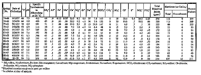
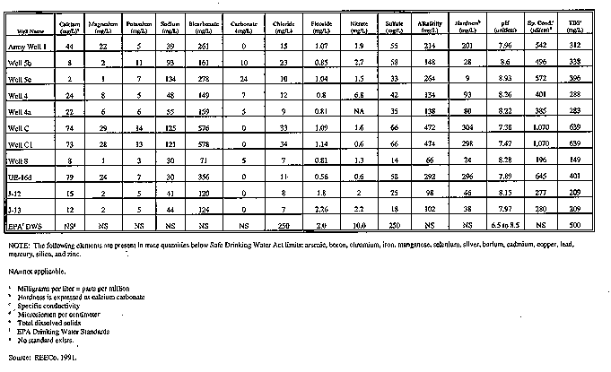