


Appendix A - Description of Projects and Activities
Appendix A contains the description of the existing and potential projects, future work activities, and services associated with the five Nevada Test Site (NTS) mission programs: Defense, Waste Management, Environmental Restoration, Nondefense Research and Development, and Work for Others. A description of NTS site-support activities is provided in Section A.6 . Table A-4 , located at the end of this appendix, presents the resource demands and requirements of the component projects and anticipated activities of mission programs at the NTS. These data were the basis of detailed environmental analyses described in Chapter 5 . The back portion of Table A-4 outlines the primary assumptions used to develop the results presented in Table A-4 . The assumptions are presented by resource type, (e.g., expenditures) and by mission program for each alternative and general assumption. Projects included in each of the alternatives are described within the mission program summaries in Appendix A. Within each section, the existing and potential future projects, activities and services associated with each alternative are described. Appendix A provides information on current projects and activities, as well as information on those projects, activities and services that could occur over the next 10 years. The purpose of this appendix is to:
- Present information used to evaluate the alternatives proposed in the NTS Environmental Impact Statement (EIS)
- Provide descriptions of the projects, activities, and services discussed in the main chapters of the NTS EIS.
A.1 Defense Program
Among the major responsibilities of the U.S. Department of Energy (DOE) at the NTS and the Tonopah Test Range is the continued stewardship of the nation’s nuclear weapons stockpile. The NTS must also maintain a nuclear weapons testing capability. Other Tonopah TestRange Defense Program responsibilities are described in Section A.1.1.4 .
A.1.1 Alternative 1
Under Alternative 1, Defense Program operations would continue under the ongoing nuclear test moratorium and negotiation of the Comprehensive Test Ban Treaty. Two scenarios could occur under this alternative. In one scenario, the President would not direct any nuclear yield testing, and the DOE’s nuclear-testing-related activities would be limited to maintaining readiness to conduct tests. This scenario emphasizes NTS science-based stockpile stewardship experiments and operations. The other scenario (which the DOE believes unlikely but consistent with the site’s historical mission) includes a contingent possibility that the President, through an end of the moratorium or through the "supreme national interest" clause of a test ban treaty, would direct the DOE to conduct one or more nuclear-yield tests in order to achieve a high level of confidence in the safety and reliability of the weapon type in question. One or more nuclear-yield tests could be conducted as directed by the President. The activities associated with this alternative are also presented below.
A.1.1.1 Stockpile Stewardship.
Stockpile stewardship includes nuclear weapons testing and science-based weapons experimentation and ensures the safety, reliability, and performance of the nation’s nuclear stockpile. The research and development of the technologies required for stockpile management are included under stockpile stewardship. The DOE Nevada Operations Office (DOE/NV) also maintains the capability of locating, retrieving, and destroying damaged nuclear weapons. Descriptions of stockpile stewardship activities addressed in the NTS EIS are provided below. These activities are related to science-based experiments which will be conducted in emplacement holes depicted in Figure A-1.
Figure A-1 Location of stockpile stewardship emplacement holes on the NTS
A.1.1.1.1 Nuclear Test Readiness
As required by Presidential directive, the DOE will maintain the readiness and capability to conduct nuclear tests within 2 to 3 years if directed by the President. With respect to the NTS under Alternative 1, this directive means that Defense Program efforts would continue to maintain the required infrastructure and critical personnel necessary to meet this requirement. The DOE will maintain personnel skills through the conduct of dynamic experiments, (including subcritical experiments, involving special nuclear material) hydrodynamic tests, and exercises. The few capabilities essential for nuclear testing not used during the experimental program will be exercised periodically to maintain the relevant skill bases. Laboratory personnel will maintain the necessary technical competency by performing selected nuclear explosive operations at the Device Assembly Facility. These operations have been analyzed in the Device Assembly Facility Environmental Assessment. The necessary infrastructure, including facilities, will be maintained in compliance with all regulatory, safety, and programmatic requirements.
A.1.1.1.2 Underground Nuclear Weapons Testing
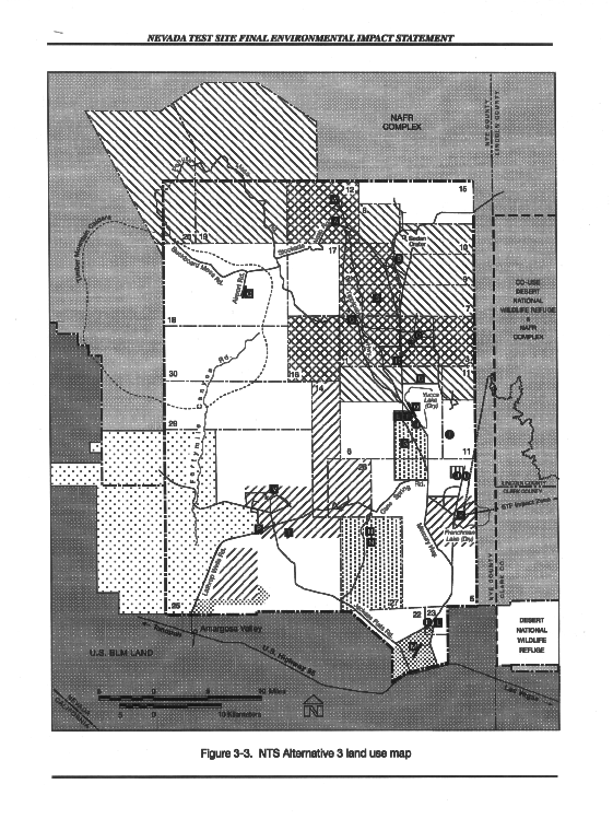
Since 1963, the United States has conducted all of its nuclear weapons tests underground in accordance with the terms of the Limited Test Ban Treaty. Hence, complete containment of all nuclear weapons tests is a dominant consideration in nuclear test operations. Various methods are used for emplacing nuclear test devices so that the ensuing explosion is contained. The most common method is to emplace a test device at the bottom of a vertically drilled hole. Another method is to emplace a test device within a tunnel that has been mined horizontally to a location that is sufficiently deep to provide containment. Emplacement of a test device in a drill hole or tunnel is not accomplished until the containment design has been reviewed by the Containment Evaluation Panel. The Containment Evaluation Panel is composed of individuals who have extensive experience in nuclear testing andassociated phenomenology. The Containment Evaluation Panel assists the Manager, DOE/NV, in the review of proposed nuclear tests to ensure that each containment design is one that will provide reasonable assurance of satisfactory containment of radioactivity or release radioactivity only under controlled conditions in compliance with all treaty constraints and under health and safety guidelines established by the Secretary of Energy. Panel membership include scientists and engineers from the Los Alamos National Laboratory, Lawrence Livermore National Laboratory, Sandia National Laboratories, the Defense Nuclear Agency, the U.S. Geological Survey, the Desert Research Institute, and up to four independent consultants. The Panel examines each factor that might contribute to the unwanted escape of radionuclides into the atmosphere during or after the detonation. Such reviews consider in detail the device yield, depth of burial, geology, hydrology, characteristics of the soil and rock, location of the emplacement site (including the proximity to and the success of previous test locations), closure methods, stemming design, and drilling and construction history. A detailed description of the steps associated with nuclear weapons tests in vertical drill holes is provided below. TESTS IN VERTICAL DRILL HOLES—Tests in vertical drill holes are of two types: smaller-yield devices in relatively shallow holes in the Yucca Flat area (Areas 1, 2, 3, 4, 5, 6, 7, 8, 9, and 10) and higher-yield devices in deeper holes on Pahute Mesa (Areas 18, 19, and 20). Tests at the Yucca Flat and Pahute Mesa event sites have the same general requirements, but differ in the magnitude of the operations. Deeper-hole operations disturb a larger area, require more on-site equipment, and have a higher requirement for electrical power and utilities. The distance from the core of the infrastructure is also a factor; Pahute Mesa operations are 48 to 81 kilometers (km) (30 to 50 miles [mi]) farther away than Yucca Flat. The following description of a vertical drill-hole test breaks down the operation into seven individual steps: Step1. Site Selection and Drilling. There are two subsets of site selection as it applies to nuclear tests, namely: selection of an existing drill hole for a specific event (Figure A-1 ), and selection of a new drill site from the Nuclear Test Zone (Figure 3-3 ) for a specific event because the stockpile does not contain a suitable site. The goal of siting is to optimize the various parameters so that operational feasibility and successful containment of yields of interest to device designers can be attained at a suitably low cost. Many factors are considered. Some of these are: (1) scheduling of field resources; (2) event schedules; (3) shock sensitivity of a given experiment and possible interactions with other experiments; (4) depth range required for a suitable device emplacement; (5) geologic structure; (6) geologic material properties; (7) depth of standing water; (8) potential drilling problems; (9) adjacent expended sites, craters, chimneys, subsurface collapses; (10) adjacent open emplacement holes or unplugged post-shot or exploratory holes; and (11) non-test program constraints such as groundwater concerns, roads, and power lines (Olsen, 1993). When drilling is required after a test location is chosen by the sponsoring national laboratory, a drilling program outlining the requirements of the specific hole is completed. The event site is surveyed, staked, and checked for cultural and biological resources. When all environmental clearances are completed, the site is graded and leveled, and a drilling-fluid sump is constructed to contain drilling fluid and cuttings. A drill rig, usually with its own power and utilities, is moved onto the site. Water is brought in by truck, or piped in, and mixed with drilling compounds to fill the sump. The hole is then drilled using standard NTS big-hole drilling techniques. A normal hole is from 1 to 3 meters (m) (48 to 120 inches [in.]) diameter and from 213 to 762 meters (m) (600 to 2,500 feet [ft]) deep. During drilling, samples of drill cuttings are collected at 3-m (10-ft) intervals, and rock cores are taken as required. After drilling is complete,geophysical logs are run into the hole to evaluate the condition of the hole and gain a more thorough understanding of the geology. The drill site is then secured by filling the sump and installing specially designed covers over the hole. Step 2. Event-Site Engineering and Construction. When a hole is selected as a location for a nuclear test, the area around the hole is surveyed and staked according to the criteria set forth by the sponsoring national laboratory. The cultural and biological surveys are then rerun to determine if the status of the area has changed. The hole is also uncovered, and selected geophysical logs are refed in the hole to reconfirm its condition. Once it is assured that the environmental clearances are complete, an area is cleared and leveled for the surface ground-zero equipment; another area close by the selected site is cleared and leveled for the recording trailer park. This is a typical earthmoving operation; native materials are used to top the pads or, if active material is unstable, decomposed granite fill is used. The on-site construction is temporary and is abandoned after the event is complete. Concrete pads are poured around the surface ground-zero to provide a stable platform for downhole operations and to provide a base for the assembly towers. Equipment is moved in to emplace the nuclear device in the hole, record the data produced, and provide radiological and seismic monitoring of the site. An extensive grounding system is used to establish baseline instrumentation grounds, which might include a pit containing salt water. The equipment to be left in position during the explosion is protected with an aluminum-foil hexcell-shaped shock-mounting material or dense foam. A circle of radiation detectors is placed back from the surface ground-zero to detect and assess any releases from the experiment. Finally, a perimeter fence is erected, and access is controlled both into and out of the event site. Step 3. Device Delivery and Assembly. For safety reasons, the nuclear device is delivered to the NTS unassembled. The device is assembled and inserted into a container at the Device Assembly Facility in Area 6 or in the Area 27 Assembly/Staging Facilities. The Device Assembly Facility is discussed at the end of this section. The device, now encased in thecontainer, is delivered to the event site accompanied by armored convoy. It is then attached to the diagnostics canister in preparation for emplacement into the hole. Checks are run, and alignment is assured. Heavy security is maintained during all operations that involve the nuclear device. Step 4. Diagnostic Assembly. A diagnostic canister is assembled off site and transported to the test site. A typical diagnostic canister might be 2 m (8 ft) in diameter and 30 m (120 ft) long and contain all the instrumentation required to receive data at the time of the explosion (real time). The diagnostic canister might contain lead and other materials as shielding for the detectors. Upon arrival at the event site, the diagnostic canister is installed in the assembly tower to be mated with the device on site. Instrumentation cables are connected to the experiments and the recording trailer park. Slack in the cables allows the diagnostic canister to be lowered into the hole. Step 5. Emplacement of the Experiment. The nuclear explosive and special measurement devices are moved to the hole and lowered to the detonation position; all required diagnostic materials and instrumentation cables are also lowered into the hole at this time. Downhole operations are conducted according to a defined checklist and are monitored by independent inspectors. The whole assembly is placed on a set of fracture-safe beams that span the opening. Any auxiliary equipment is then lowered into the hole, and the area is secured. Emplacement equipment is removed from the area, and test runs are conducted on the downhole experiment. The hole is stemmed to prevent radioactive materials from escaping during or after the experiment. Stemming materials used to backfill the hole are generally placed in alternating layers, according to the containment specification. Alternate layers of 1-centimeter (cm) (3/8–in.) pea gravel are combined with fine material to provide a barrier equal to or better than the undisturbed material. Sand, gypsum, grout, cold tar, or epoxy plugs are also placed in the hole to provide impenetrable zones. In these zones, the instrument cables are sealed to prevent a radioactive gas path to the surface. Once completed, the area is cleared ofunnecessary equipment. A report is compiled for the Containment Evaluation Panel to show that the as-built condition reflects the containment design plan. Step 6. Test Execution. After the Containment Evaluation Panel accepts the as-built design of containment and all preliminary tests are successful, the nuclear device is ready for detonation. Security operations begin two days before the test to assure that all nonevent-related personnel are evacuated prior to the test for security and personal safety. The explosive is armed. Radiation monitors are activated, and aircraft with tracking capability circle the site in case gas and debris unexpectedly vent to the surface. Weather forecasts and fallout pattern predictions are reviewed. Then, detonation occurs. When an underground nuclear device is detonated, the energy release almost instantaneously produces extremely high temperatures and pressure that vaporizes the nuclear device and the surrounding rock. Within a fraction of a second after detonation, a generally spherical cavity is formed at the emplacement position. As the hot gases cool, a lining of molten rock puddles at the cavity bottom. After a period of minutes to hours, as the gases in the cavity cool, the pressure subsides and the weight of the overburden causes the cavity roof to collapse, producing a vertical, rubble-filled column known as a rubble chimney. The rubble chimney commonly extends to the ground surface, forming a subsidence crater. Numerous subsidence craters are present at the test site (see Plate 7, Volume 2). Subsidence craters generally are bowl-shaped depressions with a diameter ranging from about 60 to 600 m (200 to 2,000 ft) and a depth ranging from a few meters up to 60 m (200 ft), depending on the depth of burial and the explosive energy yield. Some deeply buried explosions of low yield form cavities that do not collapse to the surface and, consequently, do not create subsidence craters. Past underground nuclear tests in Yucca Flat and on Pahute Mesa have fractured the ground surface above the explosions, causing displacement of the surface along preexisting faults adjacent to explosion sites. After the test is conducted, the event site remains secure until it can be assured that the event has been contained. After a suitable time, a reentry crew is dispatched to the site. Data are retrieved, and the condition of equipment is noted. After all is assured to be secure, normal NTS operations resume. The event site is roped off, outlining an exclusion zone where there is danger of potential cratering. Step 7. Post-shot Operations. After the temperature of the cavity has cooled, a post-shot hole is usually drilled into the point of the explosion in order to retrieve samples of the debris. These samples are highly radioactive, but provide important information on the test. The post-shot hole is as small in diameter as possible and is drilled at an angle to allow the drill rig to be positioned safely away from surface ground-zero. After drilling and sampling operations are complete, the drill rig and tools are decontaminated. Residual radiation is cleaned up at the site, and the hole is plugged back to the surface. This generally completes the event operation, and the site is turned back to the DOE.
A.1.1.1.3 Science-Based Stockpile Stewardship
Projects and activities associated with science-based stockpile stewardship include experiments that will provide essential data for the modeling of the performance, safety, and maintenance of the enduring stockpile. Examples of such types of projects are described below. DEVICE ASSEMBLY FACILITY—The Device Assembly Facility is a multistructure facility in which nuclear devices and high explosives can be assembled, disassembled or modified, staged, and component tested. Nuclear devices and high-explosive activities might also include maintenance, repair, retrofit, and surveillance. This facility contains approximately 9,290 square meters (m2) (100,000 square feet [ft2]) of floor space within a 29-acre (1,263,240 ft2) high-security area. Construction is primarily of heavy steel-reinforced concrete. The facility is earth-covered with a minimum of 2 m (5 ft) of compacted earth overlay, leaving only one exterior wall. There are individual underground structures separated by earthfill, and they are considered asseparate buildings within the Device Assembly Facility. These separate buildings are connected by a common corridor. Single- and two-story sections exist within the Device Assembly Facility, with ceiling heights up to 9 m (30 ft). Second-story sections are used primarily for security forces and for additional mechanical and electrical equipment space. The entire facility is provided with an automatic fire suppression system and, in areas where a nuclear device may be present, quick-response on-off sprinkler heads are also installed. Assembly operations at the Device Assembly Facility are carried out in the five assembly cells, three assembly bays, and four high bays. High explosives and special nuclear materials enter through the doors on the southeast side of the complex and are staged in bunkers. The materials are transferred to assembly cells where the components are assembled to the point that the device is no longer exposed. Completion of assembly includes mechanical and electrical measurements, radiography, radiation checks, alignment, and installation of other components. Radiographic operations are conducted on the component or assembly in the radiography bays and occasionally in the assembly cells or bays. In the final step, the assembly is configured for shipment to the event location. To provide further detail of the Device Assembly Facility, the description is divided into assembly cells, assembly bays, high bays, and other facilities as follows: Assembly Cells—The assembly cells are 10 m (34 ft) diameter work areas that include composite roofs designed to expand upward in the unlikely event of a high-explosive detonation and to collapse into the cell where the detonation occurred. The collapsed, composite roof material provides a filtration system that reduces the dispersion of aerosolized special nuclear materials by over 99.5 percent and, at the same time, absorbs the energy of an explosive blast to prevent propagation of the explosion into other structures within the facility. Decontamination facilities with tank storage are located in close proximity to the assembly cells. The assembly cells have 30 cm (12 in.) thick concrete walls and a roof structureoverlain with 8 m (25 ft) of graded gravel. Each cell has an air-locked access vestibule equipped with double sets of blast doors that are interlocked so that one door must be closed before the other can be opened. The concrete structure, composite roof, and interlocking blast doors within the assembly cells reduce the potential environmental impacts that could occur during an accident and reduce exposure to workers not located in the immediate vicinity of an accident. Assembly Bays—The assembly bays have concrete walls with separate personnel- and equipment-access air locks and interlocking blast doors to reduce potential environmental impacts and impacts to workers outside the bay. Nuclear devices containing insensitive high explosives as the only main charge explosive are assembled in assembly bays. Activities conducted in assembly bays involve the assembly of secondary components. Uncased explosives other than insensitive high explosives can be handled in these bays if no special nuclear materials are present. High Bays—Four high bays to support test operations are similar to the assembly bays in structure and function, except that no equipment airlock is provided. Nuclear device operations conducted in assembly bays may also be conducted in high bays. Two of the four high bays allow the device transportation vehicle to be backed in for loading and unloading. Other Facilities—Other facilities located at the Device Assembly Facility include the following:
- Bunkers are used for staging high explosives and special nuclear material components prior to assembly
- Mechanical and electrical support areas include plant mechanical systems, diesel-powered electrical generators, an uninterruptible battery power supply station, and transformers
- Administrative offices are located on the first floor of the Device Assembly Facility. Each corridor is provided with independent heating, cooling, and ventilation systems
- Radiography procedures are conducted in one of two buildings that have air-locked access corridors, blast doors, and support facilities comprised of a control room, service area, dark room, and radiography room
- Security is provided by an entry guard station that controls traffic ingress and egress to the complex. Two hardened guard towers constructed of reinforced concrete provide for exterior security and surveillance.
A.1.1.1.4 Dynamic Experiments and Hydrodynamic Tests
Dynamic experiments provide information regarding changes in materials under conditions caused by the detonation of high explosives. Dynamic experiments are conducted in order to gain information on the physical properties and dynamic behavior of materials used in high explosives and nuclear weapons, including changes caused by aging. Dynamic experiments may include the use of special nuclear material; however, those that are to be conducted are designed to remain subcritical. These experiments are called "subcritical experiments", i.e., no self-sustaining fission chain reaction will occur. Operations at the NTS have historically included tests or experiments that, though involving both high explosives and special nuclear materials, were intended to produce no nuclear yield or negligible nuclear energy release. These tests or experiments frequently remained subcritical. They were often performed as dedicated stand-alone experiments. Nuclear explosion did not take place, therefore, the environmental impacts of these experiments were principally due to dispersal of special nuclear materials such as plutonium, and other materials, by the detonation of high explosives. These tests or experiments were performed through the 1950s, 1960s, 1970s, and into the 1980s. Some of the earlier subcritical experiments were conducted on the surface while others were conducted underground in shafts, shallow boreholes or tunnels. Future subcritical experiments would be dynamic experiments with special nuclear materials performed to answer crucial questions concerning safety and reliability of the stockpile. Approximately 10 dynamic experiments (including subcritical experiments) or hydrodynamic tests would be conducted annually at the Lyner Complex. Hydrodynamic tests are dynamic, integrated systems tests of mock-up nuclear packages during which the high explosives are detonated and the resulting motions and reactions of materials and components are observed and measured. The explosively generated high pressures and temperatures cause some of the materials to behave hydraulically (like a fluid). Hydrodynamic tests are used to obtain diagnostic information on the behavior of a nuclear weapons primary assembly (using simulated materials for the fissile materials in an actual weapon) and to evaluate the effects of aging on the nuclear weapons remaining in the stockpile. For the purpose of impact analysis only, it is assumed that under Alternative 1, a total of 1,100 dynamic experiments or hydrodynamic testswould be performed within the 10-year timeframe(1996 to 2005) of the NTS EIS. Examples of science-based stewardship facilities and projects are described below. LYNER COMPLEX—Lyner was originally designed as a site to test low-yield nuclear devices. Since the moratorium on nuclear testing began, it has been converted to the testing of conventional high explosives, as well as dynamic experiments, subcritical experiments and hydrodynamic tests. The Lyner Complex consists of a mined shaft (U-1a), a drilled hole (U-1g), a connecting mined tunnel, and surface facilities located west of the Mercury Highway in Yucca Flat. The surface facilities include a trailer park for diagnostics and a work area around the mined shaft built with transportable structures. The Lyner Complex will be used by the National Laboratories to conduct the program of dynamic experiments and hydrodynamic tests. The U-1a shaft is 293 m (961 ft) deep, with access via a man-rated hoist. Secondary access through the drilled hole at U-1g is gained by using an emergency cage powered by a separate hoist. The U-1g drill hole also provides access for the firing and diagnostic cables. The cables and other utilities are grouted into the annulus of the 122-cm (48-in.) access casing and the 274-cm (108-in.) diameter hole. An independent ventilation system at the U-1g drill hole provides a second supply of downhole air, thus supplementing the U-1a supply and acting as a dual system in the case of an accident. The connecting main drift is mined 335 m (1,100 ft) due north to the U-1g drill hole from the U-1a shaft. Tunnel support is provided by rock bolts, wire mesh, and shotcrete. Secondary containment for experiments is located in the main drift, along with distribution of utilities. Secondary containment assures a safe condition in the event of failure of the primary containment in the side drifts. Primary containment is provided by closing the side drifts with grouts and steel containment doors. Secondary containment is achieved by massive grout plugs keyed to the rock with gas-tight steel doors within the plugs. Explosive events are placed in side drifts mined perpendicular to the main drift. Multiple tests could be fielded by the complex without changes to the main drift. The experiment drifts would be mined to suit the requirements of the experiment assigned. One experimental drift has been completed and successfully expended for the demonstration experiment. Site development includes a 3-acre recording trailer park by the U-1g hole and a 17-acre pad that contains the construction support buildings at the U-1a shaft location. Downhole support equipment includes data gathering, emergency refuge chambers, distribution conduits for air and utilities, and a freight and passenger landing at the hoist. Electrical power and water are supplied from the NTS. The Lyner site is connected to the control point by a fiber-optic cable link. An emergency evacuation system is installed with self-contained power and a dedicated hoist mechanism at the U-1g hole. The U-1g hole provides emergency access to the complex and a backup access should an accident close the U-1a shaft. Further details regarding activities conducted in the Lyner Complex are addressed in a classified appendix to the NTS EIS. However, environmental impacts of activities conducted at the Lyner Complex are included in the analysis in Chapter 5 of the NTS EIS. BIG EXPLOSIVES EXPERIMENTAL FACILITY— The Big Explosives Experimental Facility is located in north-central Area 4. The site contains seven underground structures previously associated with atmospheric testing, one set of unidentified stanchions that might have been associated with atmospheric testing, the Bare Reactor Experiment Nevada Tower foundations and stanchions and the Japanese Village complex, the U-4ad drill hole and drill sump, the U-4af exclusion zone, and a white silicified volcanic core reduction flake. These structures were abandoned when nuclear testing went underground. Two of the buried structures, bunkers 4-300 and 4-480, have been modified to accommodate modern hydrodiagnostic equipment to serve as a hydrodynamic test facility for detonations of very large conventional high-explosive charges and devices. The electrical,lighting, and ventilation systems of the bunkers have been replaced or upgraded, optical ports and electronic control conduits have been added, the area surrounding the bunkers has been graded, and earthen berms have been added to improve blast protection, shield from X-radiation, and provide a downrange projectile stop. The intent of the modifications was to provide all of the sophisticated diagnostics capability of Lawrence Livermore National Laboratory’s Site 300 Hydrotesting Facility for experiments containing more than the currently available 277-kilogram (kg) (500-pound [lb]) high-explosive weight limit. Bunker 4-480 was modified to house up to five nitrogen or helium gas-driven rotating-mirror framing cameras, laser-illuminated image-converter cameras, continuous-rotating-mirror framing cameras, rotating-mirror streaking cameras, and/or infrared imaging cameras in various combinations. It is equipped with 5 camera stands and 5 corresponding optical ports with access to the 20 m x 20 m (66 ft x 66 ft) area gravel firing pad. Bunker 4-300 contains three rooms: the control room, the laser room, and the utility room. The control and utility rooms were modified to house the diagnostic and firing control electronics, digitizers, electronic recording equipment, and other electronic equipment necessary for hydrodynamic tests. The laser room was modified to accommodate a pulsed Ruby laser for image-converter camera illumination and a neodumium laser for multibeam Fabry-Perot velocimetry, as well as the Fabry-Perot analyzer table. Three large (3m [10 ft] diameter and 6m [20 ft] long) steel cylinders were placed outside the bunkers near the firing pad to house 2.3-MeV Febetron flash X-ray sources for high-energy X-ray radiography. Hycam recorders and video monitors were also placed around the firing area to monitor the aboveground activity and experimental performance of the test devices. The structural soundness of the modified bunkers for expanded operations and the potential environmental impacts of blast, noise, and dust uplift due to hydrodynamic tests were investigated in the five experiments of the Popover test seriesconducted between March 1995 and August 1995. The tests consisted of detonations of successively larger amounts of spherical charges of conventional trinitrotoluene explosive beginning at 232 kg (512 lb) and ending with 3,538 kg (7,800 lb). The noise, acceleration, strain, overpressure, dust uplift, and area contamination were monitored in order to validate predictive models of shock, blast, noise, and gas product dispersion and to certify the safety of the manned operation of Bunker 4-300 during hydrodynamic tests. The bunkers were found to meet all required safety criteria, and a committee of senior scientists and engineers was chartered to evaluate the test results and recommended the facility for expanded operations. The high-explosive weight limit for safe, manned operations at the Big Explosives Experimental Facility is based on the following facility design criteria: 454 kg (1,000 lb) of conventional high explosives detonated 5 m (15 ft) from the Bunker 4-480 outer wall or 2,268 kg (5,000 lb) of conventional high explosives detonated 8.3 m (27 ft) from the Bunker 4-480 outer wall. Based on the results of the Popover test series, the relationship between conventional high-explosive charge mass and safe detonation distance was determined to conform to these two criteria. For experiments involving larger or smaller charge masses than previously tested or involving charge configurations different from those previously tested, the safe operating distance(s) of the charge(s) will be determined using these criteria and standard engineering practice. In this way, arbitrarily large conventional high-explosive charge masses in practically any configuration can be safely detonated as long as the equivalent impact of the detonation on the facility in terms of overpressure, blast, shock, and noise is less than or equal to the facility design criteria. Under this alternative approximately 100 hydrodynamic tests or dynamic experiments would be conducted annually at the Big Explosives Experimental Facility. No experiment performed at the Big Explosives Experimental Facility will contain special nuclear materials. A synopsis of current Big Explosives Experimental Facility projects and activities follows. Shaped Charge Scaling Project— The purpose is to develop and test large shaped-charge technology, originated within the DOE weapons laboratories, for broad counterproliferation applications. The project includes scaling the existing technology to larger sizes; developing, testing, modifying, and characterizing the performance of the large charges; and applying the scaled shaped-charges to a variety of counterproliferation missions to test effectiveness against various targets. Typical experiments involve up to 3,600 kg (8,000 lb) or more of conventional high explosives in a variety of configurations. Other High-Explosive Experiments—This includes potential projects with the goal of developing, improving testing and deploying advances in conventional munitions technology or their applications. Examples include the development of advanced conventional weapons, including shaped charges, explosively formed projectiles, propellant-driven devices, explosive munitions, pyrotechnics and other conventional weapons technologies, applications of these technologies to hard target and/or buried structure defeat, counterproliferation, and armor defeat. Typical experiments involve 3,600 kg (8,000 lb) or more of conventional high explosives in a variety of configurations.
A.1.1.2 Stockpile Management.
Under Alternative 1, no stockpile management activities would be conducted at the NTS.
A.1.1.3 Nuclear Emergency Response.
The DOE/NV Emergency Management Program is administered by the DOE/NV Emergency Management and Nonproliferation Division. The program receives significant support from the U.S. Environmental Protection Agency (EPA) Environmental Monitoring and Support Laboratory, Los Alamos National Laboratory, Lawrence Livermore National Laboratory, Sandia National Laboratories, U.S. Department of Defense (DoD) explosive ordnance demolition experts, and the DOE/NV contractors. The program is comprised of a number of separate, but related, emergency response programs, including the Nuclear Emergency Search Team, the Federal Radiological Monitoring and Assessment Center, the AerialMeasuring System, the Accident Response Group, the Radiological Assistance Program, and the DOE/NV Internal Emergency Management Program. Program activities are based at facilities in Las Vegas, Nevada; Santa Barbara, California; Andrews Air Force Base near Washington, DC; and the NTS. These activities are individually summarized below.
A.1.1.3.1 Nuclear Emergency Search Team
DOE Order 5530.2, issued September 20, 1991, requires the Manager, DOE/NV, to maintain an operational team of specialists and equipment for response to threats involving nuclear explosives, illegal use of nuclear materials, and weapons of mass destruction. The Nuclear Emergency Search Team, comprised of members from the DOE, other federal agencies, the nuclear weapon design laboratories, and the DOE/NV contractors, is prepared to provide technical assistance to the Federal Bureau of Investigation, designated by law as the lead agency for response to terrorist acts in the United States. Since 1975, when the team was formed, significant research efforts, extensive exercises, and the DOE participation in responses to large nuclear emergencies, including the reentry of the Russian Cosmos 954 nuclear-powered satellite and the Three-Mile Island reactor accident, have contributed substantially to the development of needed response capabilities.
A.1.1.3.2 Federal Radiological Monitoring and Assessment Center
The DOE has been tasked to develop and maintain the Federal Radiological Monitoring and Assessment Center program. The DOE establishes and manages the field operations center when a major radiological emergency occurs or potentially may occur. The creation of a Federal Radiological Monitoring and Assessment Center capability is mandated by the Federal Radiological Emergency Response Plan and is assigned to the DOE/NV by the DOE Headquarters. DOE Order 5530.5, published in July 1992, specifies the purpose, organization, and responsibilities associated with the establishment of a Federal Radiological Monitoring and Assessment Center. The Federal Radiological Monitoring and Assessment Center is responsible for acquiring, processing, and providing assessment ofradiological data in the field. The Federal Radiological Monitoring and Assessment Center may be called on to support or provide follow-on support to the Nuclear Emergency Search Team. The Federal Radiological Monitoring and Assessment Center is a stand-alone organization capable of responding to any type of nuclear emergency, including nuclear weapons, transportation, or power-plant-related accidents.
A.1.1.3.3 Aerial Measuring System
The Aerial Measuring System mission is documented in DOE Order 5530.4, which defines its purpose and describes its roles and responsibilities. Primary objectives of the Aerial Measuring System are to:
- Conduct aerial surveys of the DOE facilities on a periodic basis to detect changes in conditions
- Develop remote sensing, analytical, and display technology for detection of nuclear radiation, as well as spectral characteristics in the ultraviolet, optical, and infrared spectra emitted from an environment that provides information about its condition or status
- Establish and maintain a technically competent emergency response capability, including the administrative, logistical, and technical support required in situations involving radiation, radioactive materials, or other hazardous materials.
A.1.1.3.4 Accident Response Group
The Accident Response Group, which is managed by the DOE/Albuquerque Operations Office, has a mission similar to the Federal Radiological Monitoring and Assessment Center, but focuses on accidents involving United States’ nuclear weapons. The Accident Response Group deals with on-site conditions while the Federal Radiological Monitoring and Assessment Center addresses off-site measurements and assessments. The DOE/NV, through a Memorandum of Understanding with the DOE/Albuquerque Operations Office, provides field response resourcesto the Albuquerque Office Accident Response Group team in support of nuclear weapons accidents, exercises, and training. The Accident Response Group is mandated by DOE Order 5530.1A, issued on September 20, 1991. It defines the purpose of the program and clarifies the responsibilities and authorities of the DOE Headquarters and the Operations Offices. The Accident Response Group resources required are normally drawn from the DOE/NV Nuclear Emergency Search Team and Aerial Measuring System programs. An Accident Response Group mission may require any of the DOE/NV major emergency management resources. Some support requirements for this program are similar to the DOE/NV Nuclear Emergency Search Team and Aerial Measuring System programs. The use of Nuclear Emergency Search Team and Aerial Measuring System personnel, expertise, and equipment to support the Accident Response Group program eliminates the cost of duplicate services.
A.1.1.3.5 Radiological Assistance Program
The Radiological Assistance Program is prepared to furnish assistance in all types of radiological incidents. The program is mandated by DOE Order 5530.1A. Response to radiological incidents may include on- and off-site assistance when requested by other federal agencies or state, local, and tribal authorities in dealing with radiological incidents. The DOE/NV Radiological Assistance Program provides two teams, a Radiological Assistance Team and a Radiological Cleanup Team, that can respond to radiological incidents. The Radiological Assistance Team acts to control and confine hazards resulting from incidents involving radioactive material that may pose a threat to public health and safety. The Radiological Cleanup Team may provide services for radioactive material cleanup in the event of an incident involving such materials.
A.1.1.3.6 Internal Emergency Management Program
The purpose of the Internal Emergency Management Program is to ensure capabilities exist to respond to on-site emergencies. These emergencies include unusual occurrences, such as fire, bombs or bomb threats, earthquakes, aircraftaccidents, and power outages. Specific plans have been established to respond to the emergencies delineated in the current hazards assessment. The primary goals of these plans are to maximize the safety of personnel, minimize equipment and facility damage, and minimize facility downtime in the event of a major accident or emergency.
A.1.1.4 Storage and Disposition of Weapons-Usable Fissile Material
There is no activity under Alternative 1.
A.1.1.5 Large, Heavy-Industrial Facility.
There is no activity under Alternative 1.
A.1.1.6 Tonopah Test Range Activities.
The principal mission of the Tonopah Test Range is to provide research and development test support for the DOE-funded weapons projects. Many tests performed at the Tonopah Test Range involve aircraft and air drops; the range is capable of handling a wide variety of missions. Tests conducted vary from simple tests of hardware components and systems needing only limited support to rocket launches and air drops of test vehicles requiring full range support. A structural test of nuclear systems sometimes involves special nuclear material; however, all tests are performed on non-destructive yield assemblies only. No nuclear yield testing is conducted on the Tonopah Test Range. The principal types of tests include impact tests, passive tests, and chemical tests. An impact testing program has been developed to test various parameters of the weapon while in flight or dropping a weapon and through the actual penetration of the ground surface. The data obtained assist in weapons development, as well as the maintenance of the nation’s weapons stockpile. The weapons include conventional, nuclear, and inert projectiles. The weapons are unarmed and, for nuclear munitions, a portion of the nuclear package has been omitted. The nuclear weapons are, therefore, unable to reach criticality. Impact tests include the following:
- Air Drop Operations
- Fixed Rocket Launcher Operations
- Artillery Operations
- Cruise Missile Operations
- Compressed Air Gun (Davis Gun)
- Seismic Verifications
- Fuel Air Explosives Operations
- Hazardous Burn Test Operations
- Underground Explosives
- Open-Air Explosives
- Post-Test Procedures and Recovery
- Liquids (burn, explosive)
- Gas (burn, explosive)
- Particle (graphite, smoke).
- Telemetry, Microwave, and Photometrics Operations
- Radar Operations
- Laser Tracker
- Radiographic Operations
- Electromagnetic Radiation Test.
A.1.2 Alternative 2
No Defense Program activities would occur at the NTS under Alternative 2. DOE, Albuquerque mission related Defense Program activities at the Tonopah Test Range would be the same as those described under Alternative 1.
A.1.3 Alternative 3
Under this alternative, all NTS Defense Program activities described under Alternative 1 would continue. Many new activities would also be included under Alternative 3.
A.1.3.1 Stockpile Stewardship.
Activities are essentially the same as those described under Alternative 1. However, hydrodynamic tests and dynamic experiments at the Big Explosives Experimental Facility would be expanded to include larger high-explosive charges and potentially hazardous materials. These tests are described below in Section A.1.3.1.3 .The requirements of a science-based stockpile stewardship require the design and construction of large, new pulsed-power and accelerator based simulation machines. Examples of such machines include the National Ignition Facility, the Advanced Radiation Source, Dual Axis Radiographic Hydrodynamic Test Facility, and the Advanced Hydrotest Facility. All these machines share a support infrastructure. Thus, a national test and demonstration center, based on the capabilities of these machines, is a future use of the NTS. Activities performed would be based on the capabilities of these devices, including such diverse activities as fusion research, effects testing, accelerator and pulsed power component testing and development, transmutation of elements, and basic physics research.
A.1.3.1.1 Nuclear Test Readiness
Activities would be the same as those described under Alternative 1.
A.1.3.1.2 Underground Nuclear Weapons Testing
Activities would be the same as those described under Alternative 1.
A.1.3.1.3 Science-Based Stockpile Stewardship
Under Alternative 3, the total number of dynamic experiments including subcritical experiments, and hydrodynamic tests conducted at the NTS would be the same as those identified under Alternative 1 (1,100 during the 10-year period). However, dynamic experiments and hydrodynamic tests at the Big Explosives Experimental Facility would be expanded to include larger high-explosive charges and potentially hazardous materials, such as beryllium, depleted uranium, deuterium, and tritium. Additional information on potentially hazardous materials associated with dynamic experiments and hydrodynamic tests is provided in Appendix F and classified Appendix J . Examples of experiments to be conducted at Big Explosives Experimental Facility include: SHAPED-CHARGE SCALING PROJECT—The purpose is to develop large shaped-charge technology, originated within the DOE weapons laboratories, for broad counterproliferation applications. The project includes scaling the existing technology to larger sizes; developing, testing, modifying, and characterizing the performance of the large charges; and applying the scaled shaped-charges to a variety of counterproliferation missions to test effectiveness against various targets. Under Alternative 3, typical proposed experiments would involve up to 32,000 kg (70,000 lb) of conventional high explosives in a variety of configurations and the use of beryllium, depleted uranium, deuterium, and tritium. OTHER HIGH-EXPLOSIVE EXPERIMENTS— In addition to activities in Alternative 1, high-explosive experiments in Alternative 3 would include the use of novel methods to initiate detonation of several elements and/or pieces and/or points of conventional high explosives with a high degree of simultaneity. Under Alternative 3, typical proposed experiments would involve 9,072 kg (20,000 lb) or more of conventional high explosives in a variety of configurations.
A.1.3.1.4 Advanced Nuclear Weapons Simulators
— Enhancements to the science-based Stockpile Stewardship Program include advanced nuclear weapons simulators that are being considered for development based on new data and technologies emerging from current research. Advanced nuclear weapons simulators use state-of-the-art technologies to acquire data critical to evaluating the safety and reliability of the Nation's nuclear weapons stockpile in the absence of underground testing. The Next Generation Radiographic Facility and the Next Generation Magnetic Flux Compression Generation Facility are two examples of conceptual advanced simulator facilities that are analyzed for land-use planning purposes. The Next Generation Radiographic Facility and the Next Generation Magnetic Flux Compression Generation Facility are proposed for the future and,at this time, neither of these facilities will be analyzed in detail in the Stockpile Stewardship and Management EIS. Therefore, no siting decision will appear in the Stockpile Stewardship and Management Programmatic EIS Record of Decision; however, the DOE believes that both facilities could be sited within the next 10 years. For this reason, both facilities are included under Alternative 3. Because the actual operation of the next Generation Radiographic Facility is beyond the timeframe covered by the NTS EIS, only the construction phase is addressed in this EIS. Both operations and construction of the Next Generation Magnetic Flux Compression Generation Facility are included. A brief description of both conceptual facilities is provided as follows: NEXT GENERATION RADIOGRAPHIC FACILITY—The Next Generation Radiographic Facility is potentially the next advanced high-explosive test facility featuring multiple-pulse and multiple-view diagnostic capability. This facility is described as the Advanced Hydrotest Facility in the Stockpile Stewardship and Management Programmatic EIS. The conceptual facility would provide advanced radiographic machine diagnostics with multiple (e.g., four to eight) views and with multiple (e.g., four to ten) pulses per view to provide weapons performance, safety and reliability information, to satisfy as necessary, certain needs of science-based stockpile stewardship and management programs. This next generation facility would incorporate all the latest diagnostics and provide for dynamic experiments with special nuclear materials as well as conventional explosives. This type of facility would respond to Stockpile Stewardship and Management Program requirements for inferring nuclear performance and safety. This type of facility would be used for the investigation of the dynamics of metals subjected to the forces of a high-explosive detonation. It would be a permanent facility whose most prominent feature would be the use of containment spheres (firing chambers). The chambers would be used to contain conventional explosions, with the purpose of investigating the response of metals being drivenby the explosive energy. Diagnostic equipment might include a state-of-the-art advanced diagnostic and detection system to characterize high-explosive explosions. Monitoring and control facilities for firing, personnel access, safety and health physics would also be included. Special nuclear materials would be involved, however, these experiments would be designed to remain subcritical i.e., no self-sustaining nuclear reaction would occur. In addition to the containment spheres, the facility could include an open-air firing capability, shot staging areas, diagnostic support, maintenance facilities, monitoring, instrumentation and control facilities, office and administrative areas, and electrical and mechanical support shops. NEXT GENERATION MAGNETIC FLUX COMPRESSION GENERATION FACILITY— The next Generation Magnetic Flux Compression Generating Facility could be designed to provide a cost-effective facility capable of supporting high energy, explosively powered experiments. This facility is described as High-Explosive Pulsed Power Facility in the Stockpile Stewardship and Management Programmatic EIS. In broadest terms, the facility could support experiments that could make 100 to 1,000 megajoules of electrical energy available to power experiments. Typical proposed experiments could involve 4,536 kg (10,000 lb) or more of conventional high explosives in a variety of configurations. Individual experiments could involve consumable hardware, recording and diagnostic equipment, physics designers, engineers, and diagnosticians. Each individual experiment could require the assembly of custom hardware, the installation of explosive components, diagnostic, and data-recording equipment. The experiment would then be moved to the hardened firing location. The experiment would be executed, and data would be remotely recorded. Individual experiments could be fielded by a personnel team who would spend several weeks at the NTS. Several experiments could be scheduled per year. A support team of two to four people permanently located at the NTS Next Generation Magnetic Flux Compression Generation Facility would be requiredto operate and maintain the buildings and equipment, coordinate NTS support and services, interface with the experimental teams that field individual experiment, and ensure safety and environmental integrity of the varied operations. The facility could be located at the Big Explosives Experimental Facility. The existing facility may require reconfiguration and suitable office and support space is available, but may require modification. A new hardened remote structure rated at 3,000 kg (6,614 lb) to support pulsed-power equipment and explosive experiments would be required, as well as a sitewide remote control, diagnostic, and interlock system. A modest pulsed-power laboratory suit for pretesting the equipment prior to committing that equipment to full-scale operation would be required. This would be performed largely using existing equipment. Some upgrade of the electrical utility service to the area would be required. NATIONAL IGNITION FACILITY—The goal of the National Ignition Facility is to produce ignition and energy gain in Inertial Confinement Fusion targets and perform high-energy-density and radiation-effects experiments in support of national security and civilian objectives. The National Ignition Facility would be a key component in the DOE's science-based Stockpile Stewardship Program to ensure the safety and reliability of the Nation's remaining stockpile of nuclear weapons. The National Ignition Facility would make it possible to study, for the first time in a laboratory, radiation and plasma physics at a temperature and pressure regime similar to some aspects of nuclear weapon detonations. It would also provide a unique source for the study of the weapon effects on other systems. The weapon science information generated through the National Ignition Facility experimentation and research would be used to examine specific physical effects of changes due to aging or remanufacturing, and to improve the computer codes needed to certify the reliability of the remaining stockpile. In addition, the National Ignition Facility could provide a high-fidelity source for weapon effects studies that is beyond the capabilities of any other laboratory source. The National Ignition Facility would also advance civilian application for inertial confinement fusion. The National Ignition Facility ignition and gain experiments would determine whether the inertial fusion approach to a fusion energy source for long-range commercial use is feasible. The National Ignition Facility would be a key research facility that would help keep the United States the leader in the development of inertial fusion energy. The National Ignition Facility would also provide important basic scientific research and technological development capabilities. National Ignition Facility experiments would duplicate conditions in the center of the sun, which would promote and expedite advancements in astrophysics, plasma physics, and other basic sciences. Other advances that might be a result from National Ignition Facility use and research include large-scale precision optics, rapid crystal growth technology, advanced X-ray lithography for integrated circuit manufacturing, advanced health care technologies, new material development, and various scientific and analytical instrumentation. The DOE has two proposed sites for the National Ignition Facility in Nevada. One is at the NTS in Area 22, southwest of Mercury. The proximity to Mercury would be advantageous for accessibility to infrastructure support that would be needed in support of National Ignition Facility activities. This location would also be advantageous for accessibility to the facility by commercial and other nondefense personnel that would require clearance prior to access of the forward areas of the NTS. All work that presents the potential for exposure or contamination would receive special consideration and planning, including, but not limited to, dry-run practices, condition monitoring experiments, and personnel protective equipment upgrade analysis. Existing equipment, such as anticontamination clothing and personnel protective equipment, would be available for use at the National Ignition Facility. This type of reusable equipment would be decontaminated on site at the laundering and cleaning facilities available at the NTS. Located on an 80-acre site in the city of North Las Vegas, Nevada, the North Las Vegas Facility supports DOE/NV Operations Office and Lawrence Livermore National Laboratory, Los AlamosNational Laboratory, and Sandia National Laboratories weapons test programs and is considered an adjunct to the NTS. The facility supports test pre-staging activities and fabrication, assembly, and testing of field diagnostic systems that collect data from the NTS weapons testing activities. This facility is being considered as an alternative location for the National Ignition Facility. Construction of the National Ignition Facility would occur on a 45-acre parcel of previously undisturbed land. Five new buildings would be constructed on this site. An underground water pipe line would likely be built to supply the National Ignition Facility. The design and construction of a storm drain system would depend on the specific layout of the facility and its proximity to existing roads and structures. Sanitary wastewater would be treated using a sewage lagoon system dedicated to the National Ignition Facility. Nonhazardous solid waste would be handled on site in designated landfill areas. Hazardous wastes (liquid and solid) would be sent off site to permitted treatment, storage, and disposal facilities outside Nevada. Solid radioactive wastes could be disposed of at the NTS. Plans are under way for a low-level liquid waste treatment facility at the NTS. Current plans are to permit mixed solid waste disposal units at the NTS for wastes that meet Resource Conservation and Recovery Act land disposal restriction requirements. Low-level mixed liquid wastes could be stored at the Area 5 Radioactive Waste Management Site until an on-site treatment facility was available. If such a facility is not developed, low-level mixed liquid waste would be shipped to off-site facilities with appropriate treatment and disposal capabilities. The North Las Vegas Facility has adequate site infrastructure to support the proposed National Ignition Facility without major modifications. About 3 million L/yr (0.8 million gal/yr) of water would be required for construction. The total raw water supply required for the National Ignition Facility operations would be about 153 million L/yr (40 million gal/yr), of which 18 million L/yr (4.8 million gal/yr) would be for domestic use. The water required for National Ignition Facility operations would be equivalent to an increase of220 percent over the current usage of 69 million L/yr (18 million gal/yr). Sanitary wastewater volume is estimated to be 72.55 million L/yr (17.7 million gal/yr). Water supply and sanitary wastewater treatment are provided by the city of North Las Vegas. Current water and wastewater utility capacity would be adequate to meet the additional requirements for the proposed National Ignition Facility.
A.1.3.2 Stockpile Management
Stockpile management is the hands-on, day-to-day functions and operations involved in maintaining the enduring nuclear weapons stockpile. This includes assembly, disassembly, modification, and maintenance of nuclear weapons; quality assurance testing of weapons components; and the interim storage of nuclear weapons and components. Currently, the vast majority of this work is conducted at the Pantex Plant near Amarillo, Texas. Under Alternative 3, activities associated with stockpile management could be undertaken.
A.1.3.2.1 Construction of a Stockpile Management Complex
—Under Alternative 3, Pantex stockpile management operations could be transferred to the NTS. Therefore, this alternative includes the construction of a full-scale stockpile management complex at the NTS. Relocation of Pantex operations to the NTS would require the construction of approximately 30,379 m² (327,000 ft2) of new facilities centered around the Device Assembly Facility in Area 6. These facilities would be necessary to perform the following operations:
- Disassembly of nuclear weapons
- Modification and maintenance and surveillance of nuclear weapons
- Quality assurance testing of weapons components
- Assembly of nuclear weapons
- Storage of strategic reserves of special nuclear material.
A.1.3.3 Nuclear Emergency Response
Activities would be the same as those described under Alternative 1.
A.1.3.4 Storage and Disposition of Weapons-Usable Fissile Materials.
The DOE is responsible for management, storage, and disposition of weapons-usable fissile materials from the nation's nuclear weapons dismantlement and weapons production processes. Weapons-usable fissile materials include plutonium, highly enriched uranium, and other materials. These materials are currently stored at eight DOE sites across the nation: Pantex, Hanford, Idaho National Engineering Laboratory, Rocky Flats Plant, Savannah River Site, Lawrence Livermore National Laboratory, Los Alamos National Laboratory, and Oak Ridge Reservation. The DOE is in the process of preparing a Programmatic EIS to evaluate alternatives for long-term storage of all weapons-usable fissile materials and disposition of surplus weapons-usable fissile materials. Five sites, including the NTS, are under consideration for a consolidated long-term storage site. This Programmatic EIS is expected to be completed in 1996.
A.1.3.4.1 Storage of Weapons-Usable Fissile Materials
—The NTS can develop the capability of storing weapons-usable fissile material that results from the output of the disassembly process. Two options have been investigated. One option involves the construction of either a new plutonium storage facility, or a new plutonium storage facility and a highly enriched uranium storage facility depending on the programmatic storage alternative selected. These facilities are proposed to be located in Area 6 near the Device Assembly Facility. This capability may limit other uses of the facility, but is a viable option. The changes required would be internal, with no major modifications to the building. The other option is to utilize one of the horizontal event tunnels as the monitored storage site. P-Tunnel has been proposed as a potential site. Other tunnels are available, however they would require extensive modification. The selected tunnel would have a new drift driven off the existing main access drift and would be dedicated to the storage of the device pits and/or other special nuclear material.An automatic retrieval system would be installed to be able to call the stored material up for periodic checking. The total operation would be conducted underground, minimizing security and safety issues. Little modifications would be needed to secure the P-Tunnel portal area. It is unlikely that previously undisturbed land would need to be used for the construction of security fences or any other security structures or facilities. P-Tunnel is 40 km (25 mi) from the proposed site slated for disassembly, so a transportation system would be required. The road and security infrastructure is in place and would require only some upgrade and maintenance. If a tunnel other than P-Tunnel were designated, the tunnel would require extensive upgrades to meet standards of safety, ventilation, and access in addition to inspections to assure the safety of the in-place work.
A.1.3.4.2 Disposition of Weapons-Usable Fissile Materials
—There are three main categories for disposition of plutonium each with several alternatives. There are a range of facilities that could be constructed including pit disassembly/conversion, plutonium conversion, immobilization, mixed oxide fuel fabrication, and evolutionary light water reactor. Some of these are mutually exclusive. The Record of Decision for the Storage and Disposition of Weapons-Usable Fissile Materials Programmatic EIS would only select the technology not the site. The large heavy-industrial facility, described in Section A.1.3.5 , is representative of impacts that might be expected if the NTS were selected for example as a site for a mixed oxide fuel fabrication facility.
A.1.3.5 Large, Heavy-Industrial Facility
Under Alternative 3, an area has been set aside to be used by industrial facilities. For this EIS a large heavy-industrial facility has been assumed to determine maximum potential impact. A land disturbance of 600 acres and employment of 4,000 individuals are assumed for this facility. Those other resources required to support such a facility (e.g., water requirements, waste management requirements, and fuel requirements) were considered in the analysis of impacts resulting from construction and operation of this facility.
A.1.3.6 Tonopah Test Range Activities
Activities would be the same as those described under Alternative 1, with the addition of several potential tests included under this alternative.
A.1.3.6.1 Potential Tests
—Activities could include those described under Alternative 1. Additional tests proposed under Alternative 3 could include the following:
- Robotics (handling, application, and recovery of hazardous [chemical] material)
- Smart Transportation - Preprogrammed/Remote Control Vehicles (air and ground)
- Smoke Obscuration Operations
- Thermal Test Operation Facility
- Climatic Test Operation Facility
- Armor/Anti-Armor Tests
- Infrared Tests
- Seismic Verification Studies
- Rocket Development, Testing and Deployment.
A.1.4 Alternative 4
Under Alternative 4, the DOE would discontinue all defense-related activities at the NTS. At the Tonopah Test Range, the same passive tests identified under Alternatives 1, 2, and 3 would be conducted related to the DOE, Albuquerque mission. Seismic verification impact tests and the following proposed tests would also be conducted under Alternative 4:
- Robotics (handling, application, and recovery of hazardous chemical material)
- Smart Transportation - Preprogrammed/Remote Control Vehicles (air and ground)
- Climatic Test Operation Facility.
A.2 Waste Management Program
The primary mission of the NTS Waste Management Program is to serve as a low-level waste disposal facility in support of the DOE. The NTS provides disposal capability for NTS-generated waste and other DOE-approved waste generators. The NTS will continue to store existing transuranic and transuranic mixed waste pending the opening of the Waste Isolation Pilot Plant. Hazardous waste will be accumulated and stored at the Resource Conservation and Recovery Act Part B permitted storage facility, and the majority will be sent off site for treatment or disposal after storage. Waste explosives will be treated in the Resource Conservation and Recovery Act Part B permitted Explosive Ordnance Disposal Unit. Hazardous waste from off site will not be accepted at the NTS. Mixed waste will be stored pending characterization and disposal certification activities. Closure of inactive waste sites will take place. The NTS waste management activities are conducted in four primary areas: Areas 3, 5, 6, and 11. The remainder of this section describes the types of wastes that are managed and the performance assessments that are in progress to support the management of radioactive wastes. There is no long-term storage or disposal of hazardous, radioactive, or mixed waste on the Tonopah Test Range. All hazardous waste are shipped off site for ultimate disposition. WASTE TYPES—Radioactive waste is solid, liquid, or gaseous material that contains radioactive nuclides regulated under the Atomic Energy Act of 1954, as amended, and of negligible economic value considering costs of recovery. Mixed waste is waste containing both radioactive and hazardous components as defined by the Atomic Energy Act and the Resource Conservation and Recovery Act, respectively. Mixed waste intended for disposal must meet the land disposal restrictions as listed in 40 CFR Part 268. Low-level waste is defined as radioactive waste not classified as high-level waste, transuranic waste, or spent nuclear fuel or the tailings or wastes produced by the extraction or concentration of uranium or thorium from any ore processed primarily for itssource material content. Test specimens of fissionable material irradiated for research and development only, and not for the production of power or plutonium, may be classified as low-level waste, provided the concentration of transuranic elements is less than 100 nanocuries per gram. Low-level mixed waste is low-level waste that also includes hazardous components as identified in 40 CFR Part 261, Subparts C and D. Transuranic waste is radioactive waste containing alpha-emitting radionuclides having an atomic number greater than 92 and half-lives greater than 20 years in concentrations greater than 100 nanocuries per gram. Transuranic mixed waste is waste containing both transuranic and hazardous components, as identified in 40 CFR Part 261, Subparts C and D. Hazardous waste is waste that is designated as hazardous by the Environmental Protection Agency or State of Nevada regulations. Hazardous waste, defined under the Resource Conservation and Recovery Act, is waste from production or operation activities that pose a potential hazard to human health or the environment when improperly treated, stored, or disposed. Hazardous wastes are identified on special EPA lists or possess at least one of the four following characteristics: (1) ignitability, (2) corrosivity, (3) reactivity, and (4) toxicity. Radioactive waste disposal operations began at the NTS in 1961. Radioactive, mixed, hazardous, and classified waste was disposed in select pits, trenches, landfills, and greater confinement disposal boreholes on the NTS. Near-surface burial (3 to 20 m deep [10 to 60 ft]) of low-level waste and low-level mixed waste in subsidence craters, pits, and trenches has been the historical practice at the NTS. Greater confinement burial (33 to 40 m deep [70 to 120 ft]) was adopted as a concept in 1981 by the DOE for wastes that are not appropriate for near-surface disposal due to the radioactive exposure levels from the waste. Specifically, these waste types include certain high-specific-activity low-level waste (for example, fuel rod cladings and sealed sources), transuranic waste, and someclassified wastes. Projected waste volumes were obtained from various sources depending on which alternative was described. Low-level waste projections were compiled from (1) waste generator forecasts provided to the DOE/NV per requirements in the waste acceptance criteria ( DOE, 1992) the 1994 Baseline Environmental Management Report (DOE, 1995a); (3) the 1994 Integrated Data Base Report (DOE, 1994); and (4) the Draft Waste Management Programmatic Environmental Impact Statement (DOE, 1995b). Projected mixed waste volumes were obtained primarily from the DOE Headquarters database for the Mixed Waste Inventory Report and Baseline Environmental Management Report. PERFORMANCE ASSESSMENTS—Waste management activities at the NTS have completed or are in the process of completing performance assessments. The assessments are as follows: The Area 5 Radioactive Waste Management Site Performance Assessment font color="#ff0000">Shott et al., 1995)– addresses the post-1988 waste source term for the facility and was submitted to the DOE Peer Review Panel in August 1995 for technical review and recommendation. Panel review and dialogue are now in progress. Depending on the extent of the Peer Review Panel review comments and recommendations, the Area 5 report should be published by January 1997. The Area 5 Radioactive Waste Management Site Composite Analysis will include the pre-1988 waste source-term analysis, as stated in the Implementation Plan, Defense Nuclear Facilities Safety Board Recommendation 94-2 (DOE, 1995c). Refer to Volume 1, Section 2.5.6 for more information on Performance Assessments and Composite Analyses. Fernald Byproduct Waste Performance Assessment–Operable Unit 4 vitrified silo wastes from Fernald are being evaluated for disposal at the NTS in deeper confinement disposal configurations, under Chapter III of DOE Order 5820.2A, as a small quantity of byproduct material. The Fernald Byproduct Waste Performance Assessment is currently in progress and is scheduled for draft completion by September 1996. Operable Unit 4 vitrified silo wastes are characterized by high-specific activity and longer-lived radionuclides (such as uranium, thorium, and their daughter products). Selection of the NTS for disposal of the Operable Unit 4 vitrified silo waste is supported by very favorable site-specific characteristics, particularly the "no groundwater pathway" conceptual model, and by very low population density. Scientists predict no movement of direct rainfall through waste cells to the deep groundwater because of the presence of thick, dry sediments and rock in combination with very low precipitation levels and high evapotranspiration rates (Shott et al., 1995). Treatability studies conducted on the vitrified waste form indicate that the vitrified waste fully satisfies NTS waste acceptance criteria and may provide a higher level of long-term protectiveness (DOE, 1993) (Battelle, 1994). Performance assessment analyses will rigorously test various disposal scenarios over a 10,000-year period. The limiting analysis for waste acceptance for disposal is expected to be the inadvertent human intruder dose assessment. The Area 3 Radioactive Waste Management Site Performance Assessment—will address the post-1988 waste source terms for the facility and is scheduled for submittal to DOE Headquarters in March 1998. Site-characterization of Area 3 in 1996 focuses on completion of a 152-m (500-ft) exploratory borehole beneath subsidence crater U-3bh (a reserve low-level waste cell at the Area 3 Radioactive Waste Management Site). The primary objective of the exploratory borehole in Area 3 is to characterize the physical and hydrologic properties of the chimneys and to assess the potential for downward groundwater movement and radionuclide transport. The underground shot cavities beneath the subsidence craters and waste cells in the Area 3 Radioactive Waste Management Site are much deeper than active hydrologic surface processes (infiltration, redistribution, and evapotranspiration) operating beneath the Waste unit from the ground surface to a depth of approximately 31 m (100 ft). Current scientific models suggest that the chimney beneath the low-level waste unit does not enhance or promote vertical groundwater flow between the waste unit (subsidence crater) and the deep-shotcavity. This conceptual model was confirmed by hydrologic data obtained in 1996 from the exploratory borehole completed beneath U-3bl. Water potential data indicate that there is no groundwater movement from a 40-m to 96-m (131-ft to 315-ft) depth within the subsurface chimney (Van Cleave, 1996). Given the proximity of Area 5 to Area 23 (22 km [14 mi]) and the very similar hydrologic conditions, the defensible hydrogeologic conceptual model for Area 5 is being tested and validated for the Area 3 Radioactive Waste Management Site. Refer to Volume 1, Section 2.5.6 for more information on Performance Assessments and Composite Analysis. Transuranic Waste Performance Assessments— Two transuranic waste performance assessments are in review or preparation stages: (1) Greater Confinement Disposal Performance Assessment within the Area 5 Radioactive Waste Management Site and (2) Transuranic Waste in Trench T04C Performance Assessment (Area 5 Radioactive Waste Management Site). Each transuranic waste performance assessment evaluates individual transuranic source-term contributions within the Area 5 Radioactive Waste Management Site facility operation based on the containment performance objective, at a minimum. The rationale for this comparison is that the containment standard is the most limiting of the three quantitative standards given in EPA regulation 40 CFR Part 191: containment, individual protection, and groundwater, described briefly as follows (Price et al., 1993):
- The containment requirement assesses the probability of cumulative releases of radionuclides to the accessible environment over 10,000 years, considering all significant processes and events that might affect the disposal system. The accessible environment consists of any point in the subsurface that is 5 km (3 mi) beyond the waste unit and any point on the ground surface. The limit on cumulative releases depends on the initial radionuclide inventory
- Individual protection requirements are designed to protect individuals for 1,000 to 10,000 years after closure of the disposal site(the compliance period is dependent on site-specific conditions). They place limits on the annual dose equivalent received by any member of the public as a result of the disposal system. These limits are 25 milliroentgen equivalent man (mrem) to the whole body and 75 mrem to any critical organ. All potential pathways from the disposal system to people must be considered
- Groundwater protection requirements are designed to protect specific aquifers in the vicinity of the disposal site by placing limits on concentrations of radionuclides in sources of groundwater. In addition, they place limits on the annual dose equivalent received by an individual as the result of drinking water from these specific aquifers. The regulatory period for evaluation is 1,000 or 10,000 years, depending on site-specific conditions.
A.2.1 Alternative 1
Under Alternative 1, ongoing Waste Management Program activities at the NTS would continue at current levels. No significant new initiatives or projects are included under this alternative.
A.2.1.1 Area 3 Radioactive Waste Management Site.
A portion of Area 3 is reserved as a low-level waste disposal site under regulatory provisions derived from the Atomic Energy Act. The area has been designated as the Area 3 Radioactive Waste Management Site and includes seven subsidence craters created from underground nuclear weapons tests. Bulk low-level waste is disposed of in these subsidence craters. Waste management facilities are described in the following manner. The most basic is the cell, which includes trenches, pits, and craters. These are grouped together to make up units, such as the 20 cell Mixed Waste Disposal Unit. Units are placed in Radioactive Waste Management Sites such as the ones in Areas 3 and 5. The Area 3 Radioactive Waste Management Site encompasses approximately 128 acres of land and two support buildings located within the allocated boundaries of the facility. Two craters (U-3ax and U-3bl) were combined into one disposal cell that is completely filled. Two other craters (U-3ah and U-3at) were also combined into one disposal cell that was approximately half-full at the beginning of Fiscal Year 1995. This disposal cell (U-3ah/at) has been operating as a low-level disposal unit since 1988. Three other craters (U-3bh, U-3az, and U-3bg) remain for use as future disposal cells if necessary. The Area 3 Radioactive Waste Management Site serves the NTS and approved off-site generators as a bulk, low-level waste disposal facility. Disposal cell (U-3ah/at) has a remaining capacity of approximately 1.7x10⁵ cubic meters (m³) (6x10⁶ cubic feet [ft3]). Under Alternative 1, this capacity is insufficient to handle forecasted waste volumes for the next 10 years; therefore, it is anticipated that one additional disposal cell (U-3bh/az) and no additional support facilities would need to be opened. The newdisposal cell would have an estimated capacity of 2.8x10⁵ m³ (1x10 7 ft³) and would receive 9x10⁴ m³ (3.2x10 6 ft³) during the 10-year period. Under this alternative, it is projected that the Area 3 Radioactive Waste Management Site will receive approximately 2.6x10⁵ m³ (9.2x10 6 ft³) during the 10-year period defined for this EIS. One disposal cell (U-3ax/bl) is filled to capacity and is required to be closed under Resource Conservation and Recovery Act and state of Nevada hazardous waste regulations due to hazardous waste constituents known to be present. This disposal cell was operated according to the requirements of the Atomic Energy Act, prior to the NTS implementation of Resource Conservation Recovery Act regulations and has been declared a mixed waste disposal cell. The DOE/NV is developing a site-specific plan for closure activities at Area 3. This plan, part of the Integrated Closure Plan, describes a closure cap design that would take into consideration the climate, geology, surface water and regional hydrology, and waste forms. This project, part of the Integrated Closure Program, has investigated the most optimum design for closure cap integrity in the arid NTS environment. Closure performance standards, which are the minimum maintenance requirements for the protection of human health and the environment, are also under development. Minimization or elimination of contaminant release and compliance with the applicable regulations and DOE orders will be considered. Closure of disposal cell U-3ax/bl will occur in the near future upon state approval of the Resource Conservation and Recovery Act closure plan. Under Alternative 1, one additional disposal cell (U-3ah/at) will also be closed.
A.2.1.2 Area 5 Radioactive Waste Management Site.
In 1961, an area northwest of Frenchman Lake was reserved as a low-level waste disposal site under regulatory provisions derived from the Atomic Energy Act. In 1977, the area was designated the Area 5 Radioactive Waste Management Site and began controlled waste management operations. DISPOSAL OPERATIONS—Operations at the Area 5 Radioactive Waste Management Site include low-level waste and limited mixed waste disposal. The Area 5 Radioactive Waste Management Siteencompasses 732 acres of allocated land, of which 92 acres are currently being used for storage and disposal. Low-level and certain mixed wastes may be disposed via shallow land burial in pits and trenches. Trench T03U, T07C, T08C, & T09C and Pits P06U, and P05U are the landfill cells open (Fiscal Year 1995) for low-level waste disposal. Pit P03U is available for mixed waste disposal. Under this alternative, the anticipated low-level waste volume is 9.0x10⁴ m³ (3.2x106 ft³) and the anticipated mixed waste volume is 500 m³ (18,000 ft3). The existing capacity will meet the disposal needs of low-level waste expected to be generated under this alternative. Greater confinement disposal technology would continue to be pursued for disposal of high specific activity low-level waste. The current inventory of mixed waste disposed in Pit P03U at the Area 5 Radioactive Waste Management Site is 8,024 m³ (2.8x105ft³). Pit P03U is currently operating under Resource Conservation and Recovery Act Interim status for disposal of mixed waste. This waste must meet the Resource Conservation and Recovery Act Land Disposal Restriction requirements prior to disposal. Pit P03U has 9.1x10⁴ m³ (3.2x10 6 ft³) of remaining capacity available for disposal, which should meet the disposal needs of low-level mixed waste expected to be generated under this alternative. Therefore, the Mixed Waste Disposal Unit would not be expanded under Alternative 1. The remaining capacity for the Area 5 Radioactive Waste Management Site low-level waste disposal pits and trenches is 1.1x10⁶ m3 (4.0x106 ft3). No sanitary landfill construction or disposal activities would occur in Area 5 under this alternative. STORAGE OPERATIONS—Under this alternative, the Area 5 Transuranic Waste Storage Pad and the Hazardous Waste Storage Unit would continue to be used to store waste. However, the proposed Mixed Waste Storage Pad would not be constructed, and the Hazardous Waste Storage Unit would not be expanded. Low-level mixed waste is currently stored on the Transuranic Waste Storage Pad in accordance with requirements of the January 14, 1994, Mutual Consent Agreement between the state of Nevada and the DOE. The agreement allows for the storage of on-site generated mixed waste until it can be treated to meet the Land Disposal Restrictions for disposal. There were 76 m3 (2,698 ft3) of mixed waste stored on the Transuranic Waste Storage Pad at the beginning of Fiscal Year 1995. The Transuranic Waste Storage Pad Cover Building, Bldg. S-29, which has 1,765 m2 (18,900 ft2 ) of usable storage space, provides protection from environmental degradation of the transuranic waste containers. The Hazardous Waste Storage Unit is a Resource Conservation and Recovery Act-permitted facility. The Hazardous Waste Storage Unit was originally constructed as a less-than-90-day hazardous waste storage unit and consists of a 9.1 m x 30.3 m (100 x 300 ft) curbed impervious concrete pad with a cover and a maximum storage capacity of 61,625 liters (L) (16,280 gallons [gal]) of containerized waste. Hazardous waste generated on the NTS would be accepted for storage at the Hazardous Waste Storage Unit for less than one year and then shipped off site for ultimate disposition. In Area 5, transuranic mixed waste is stored on a 2.05-ac asphalt storage pad, the Transuranic Waste Storage Pad, with a design capacity of 1,140 m³ (39,800 ft³). At the beginning of Fiscal Year 1995, there were 612 m3 (21,613 ft 3) of transuranic mixed waste stored at the Area 5 Radioactive Waste Management Site. All of this waste was received from the Lawrence Livermore National Laboratory. The DOE manages the current inventory of the transuranic mixed waste in accordance with the requirements of the Settlement Agreement (June 22, 1992) between the DOE and the state of Nevada, 1992. The transuranic mixed waste would continue to be stored at the Area 5 Radioactive Waste Management Site pending development of on-site characterization capability for acceptance of the waste at a DOE-designated disposal site, when one is approved. WASTE CERTIFICATION OPERATIONS— Certification activities for waste acceptance would continue under existing methods. Waste characteristics of mixed waste would be identified through generator-supplied analytical data, split samples, and expressed acceptance of the contentsof the waste package as noted in the on-site generator's report and waste manifest. No waste certification facilities would be constructed under this alternative. Waste certification activities required to meet the Waste Isolation Pilot Plant waste acceptance criteria would not be conducted, and the transuranic mixed waste would be shipped to other DOE sites for certification, handling, and disposal. CLOSURE OPERATIONS—Area 5 currently has low-level, mixed, and classified waste disposal units filled to capacity and available for closure according to DOE and EPA regulatory requirements. Filled waste Pits P01U and P02U and Trenches T01U, T02U, T04U, T06U, and T07U contain low-level waste disposed of prior to 1987 under the requirements of the Atomic Energy Act. Because mixed waste is suspected in these landfills, the entire group would be closed in compliance with Resource Conservation and Recovery Act regulations. The greater confinement disposal boreholes, used for the disposal of highly mobile, classified, or highly radioactive waste forms, would also be closed in accordance with Resource Conservation and Recovery Act regulatory requirements. Pit P04U, opened in 1988, has received only low-level waste and needs to meet only the closure requirements of the DOE orders. The DOE/NV is developing a site-specific design for closure of Area 5 that would take into consideration the climate, geology, surface water and regional hydrology, and waste forms. This project, the Integrated Closure Program, would investigate the most optimum design for successful closure integrity in the arid NTS environment. Closure of the existing 92-acre Area 5 facility would not occur until after the end of the active life of this area, beyond the scope of this EIS. A number of alternatives are being considered, from one large closure cap for the entire Area 5 Radioactive Waste Management Site to independent caps. Closure performance standards include minimum maintenance requirements, protection of human health and the environment, minimization or elimination of contaminant release, and compliance with the applicable federal and state regulations and DOE orders.
A.2.1.3 Area 6 Waste Management Operations.
The NTS would continue to store polychlorinated biphenyl (PCB) waste, in accordance with the Toxic Substance Control Act and state of Nevada regulations. All PCB waste would continue to be disposed off site at EPA-permitted facilities. Low-level and mixed waste effluent generated by the Nevada Environmental Management and Defense Program activities would be treated at the Liquid Waste Treatment System facilities to be located in Area 6. Initially, there would be two 1.9 x 10⁶ L (5 x 10⁵ gal) double-walled steel evaporation tanks for low-level wastes. However, if mixed wastes were encountered, one of the tanks would be designated as a mixed waste treatment tank. The initial phase of the site would consist of the two double-walled steel tanks, a leak detection system, yard lights, a mobile-home-type trailer to house offices and monitoring equipment, access control features, fencing, and storm water protection. If required, the facility could ultimately be expanded to handle up to1.5x107 L/yr (4.0x10⁶ gal/yr). The hydrocarbon landfill is a state of Nevada-permitted Class III disposal site located near the southern edge of Area 6. The landfill would continue to be used for the sole purpose of discarding hydrocarbon-burdened soil, septic sludge, and debris. Resource Conservation and Recovery Act regulated wastes are not accepted for disposal. The minimum remaining capacity of the disposal site is approximately 42,000 m³ (1.5x106 ft³). Approximately 15,290 m³ (5.4x105 ft³) of soil, sludge, and debris have been disposed of in the hydrocarbon landfill.
A.2.1.4 Area 11 Explosive Ordnance Disposal Unit.
The Area 11 Explosive Ordnance Disposal Unit is a thermal treatment unit rather than a disposal unit. Explosive ordnance wastes, regulated as characteristic reactive hazardous wastes under the Resource Conservation and Recovery Act, are detonated at the Explosive Ordnance Disposal Unit. The Explosive Ordnance Disposal Unit was first used in 1965 and continues to operate as a permitted Resource Conservation and Recovery Act treatment unit. The Explosive Ordnance Disposal Unit consists of a detonation pit surrounded by an earthen pad (approximately 8 m [25 ft] x 31 m [100 ft]) and ancillary equipment, including abunker and an electric shock box. The Explosive Ordnance Disposal Unit has a maximum operating capacity to treat 45 kg (100 lb) per hour or an annual capacity of 1,873 kg (4,100 lb). No explosive waste is received from outside Nevada. The Explosive Ordnance Disposal Unit has an unofficial buffer zone of approximately 503 acres in a circular area.
A.2.2 Alternative 2
Under this alternative, Waste Management Program activities would be shut down. After shutdown, on-site monitoring and security functions would be reduced and would become part of the sitewide monitoring activity.
A.2.2.1 Area 3 Radioactive Waste Management Site.
No waste closure or disposal operations would take place. Facilities would be secured, and overall NTS monitoring would take place.
A.2.2.2 Area 5 Radioactive Waste Management Site.
No waste disposal, storage, closure, or certification operations would take place. Facilities would be secured, and overall NTS monitoring would take place. No waste certification operations would take place. All activities that generate mixed waste would cease. Containerized mixed, and transuranic mixed waste would be sent to other DOE facilities for certification and treatment to meet Resource Conservation Recovery Act land disposal restriction requirements (as applicable). All operational landfill units would receive a 1.2 m (4 ft) cover of compacted native soil.
A.2.2.3 Area 6 Waste Management Operations.
No waste storage or treatment operations would take place. Facilities would be secured, and overall NTS monitoring would take place.
A.2.2.4 Area 11 Explosive Ordnance Disposal Unit.
No waste treatment operations would take place. Facilities would be secured, and overall NTS monitoring would take place.
A.2.3 Alternative 3
The Waste Management Program under Alternative 3 would include the activities described under Alternative 1, with an increase in scope to reflect alternatives considered in the Draft Waste Management Programmatic Environmental Impact Statement.
A.2.3.1 Area 3 Radioactive Waste Management Site.
Three additional low-level waste disposal units would need to be prepared to accept a total projected bulk waste volume of 7.5x10⁵ m³ (2.6x107 ft³). This volume increase is due to accepting waste from more off-site generators than are currently approved, as well as accepting an increased amount of NTS-generated waste from the site environmental cleanup activities anticipated under this alternative. One additional support building would be constructed to expand the existing support Building 3-302. The expanded facility would almost double the size of Building 3-302 by providing a portable, prefabricated structure, that includes electrical and water systems. This construction project would be a short-duration low-labor task. Bulk contaminated soils and other debris would be delivered by haulers from environmental restoration sites. These haulers would need to be surveyed and might need to be cleaned to ensure they are free from radioactive contamination prior to release from the site. Depending upon the levels of contamination encountered, there could be the need to construct a truck decontamination facility so that haulers could be cleaned prior to release from the Area 3 Radioactive Waste Management Site. In addition to the closure activity described under Alternative 1, the additional low-level waste disposal cells (U-3bh, U-3az, and U-3bg) would become filled and would then need to be closed. Increased volumes would come from additional off-site generators (including the worst-case volume from the treatment of surplus, highly enriched uranium), as well as NTS environmental cleanup operations. The total projected volume for the 10-year consideration period to be disposed of in Area 3 is 7.5 x 10⁵ m³ (2.6 x 107 ft³). This volume would be enough to completely fill the new disposal cells, in addition to the existing capacity remaining in disposal cell U-3ah/at. Even though disposal cell U-3ax/bl is declared a mixed waste disposal cell, and disposal cells U-3ah/at and U-3bh, U-3az, and U-3bg would be radioactive only disposal cells, the same or a similarly approved closure plan would beused to protect the environment by implementing the best available technology. The performance of the disposal cell U-3ax/bl closure system would be used to consider any changes that might be necessary in the closure of cell U-3ah/at.
A.2.3.2 Area 5 Radioactive Waste Management Site.
Under Alternative 3, Area 5 waste management operations would be expanded and reflect the regionalized waste management concept for the DOE complex. In addition to increasing waste capacity, facilities for the on-site treatment and certification of NTS-generated or stored wastes would be constructed. DISPOSAL OPERATIONS—Radioactive and mixed waste disposal operations would be increased to meet the demand of the additional DOE-approved generators shipping waste to the NTS. P05U, P06U, and T03U in the Area 5 Radioactive Waste Management Site would be filled to capacity. Pit P04U, was filled to capacity during 1995. Under Alternative 3, two additional low-level waste disposal cells in the Area 5 Radioactive Management Site would be opened in the next 10 years to dispose of the projected volumes of 2.5 x 10⁵ m3 (8.8 x 106 ft3). Disposal capability for low-level waste inappropriate for shallow land disposal would be expanded. Pending the approval of a modification to the Resource Conservation and Recovery Act Part B Permit application, 20 mixed waste disposal cells would be prepared to address the projected wastevolumes of 3 x 10⁵ m3 (1.1 x 107 ft3) requiring disposal under this alternative in the next 10 years. The Area 5 Resource Conservation and Recovery Act Part B Permit would be revised to address the additional mixed waste disposal capacity. Owing to these projected volumes, additional facilities and infrastructure would have to be constructed. Additional facility information is described below in Storage Operations. Pit P03U would not be used for the disposal of mixed waste under Alternative 3. STORAGE OPERATIONS—A low-level waste storage unit would be constructed under Alternative 3. The low-level waste storage would be a curbed concrete pad located at the Area 5 Radioactive Waste Management Site. Most of the pad would be covered with a roof. The uncoveredportion would serve as an unloading platform and as an additional storage area for solid material. The pad would provide approximately 279 m2 (3,000 ft2) of storage area for waste awaiting examination prior to disposal. Storage would also be made available for the DOE sites that do not have adequate storage capacity. The hazardous waste storage unit under Alternative 3 would be increased to 0.138 acres in size, with a capacity of 208,175 L (55,000 gal) to address the additional needs of the NTS Defense and Environmental Restoration Programs. The NTS Resource Conservation and Recovery Act Part B permit application would be modified to address the additional storage capacity. A mixed waste storage unit is planned to be constructed pending the approval of the Resource Conservation and Recovery Act Part B Permit application. The mixed waste storage unit would be an epoxy-coated, curbed, concrete pad located inside the existing Area 5 Radioactive Waste Management Site. Most of the pad would be covered with a roof. The uncovered portion would serve as an unloading platform and as an additional storage area for solid material. The pad would provide approximately 279 m2 (3,000 ft2) of storage area. The pad would serve the expanded needs of the Environmental Restoration and Defense Programs activities. The unit would store mixed waste in need of technology development and facility construction that can properly reclaim, recycle, treat, or dispose of the waste. Currently, mixed waste that cannot be disposed of in Pit P03U of the Area 5 Radioactive Waste Management Site is stored on the transuranic waste storage pad in the Area 5 Radioactive Waste Management Site. This storage pad would operate under a Mutual Consent Agreement between the DOE and the state of Nevada. In addition, the pad would be available, pending approval from the State, for sites requiring emergency assistance for storage of DOE mixed waste for up to 1 year. The NTS transuranic and transuranic mixed waste would be stored, certified, and eventually transported to the Waste Isolation Pilot Plant when it becomes operational. A transuranic waste examination facility would be constructed to handlebreaching and certification of this waste before it is transported to a designated disposal facility. The Transuranic Waste Storage Pad Cover Building (Bldg. S-29) would serve as the loading facility. TREATMENT AND CERTIFICATION OPERATIONS—A waste examination facility comprised of the waste breaching and sampling building and the real-time radiography building would be constructed. The waste breaching and sampling building would be used to conduct on-site verification and certification of mixed wastes that are accepted for disposal at the Areas 3 and 5 Radioactive Waste Management Sites. This facility would house a breaching room for opening and viewing waste, a sampling facility for the collection and preparation of samples for chemical and radiochemical analysis, and an office and shower/change room. Remote package handling and decontamination capability would be included. Waste determined to be mixed through these verification activities would be returned to the waste storage area for further disposition or, if conditions warrant, returned to the generator if unacceptable. A real-time radiography building would be constructed at the Area 5 Radioactive Waste Management Site and operated by the DOE/NV in conjunction with the waste breaching and sampling building to conduct verification of mixed waste received at the Areas 3 and 5 Radioactive Waste Management Sites. Real-time radiography imagery is a nondestructive, noninvasive method used to provide preliminary package examination before breaching questionable packages for waste sampling. Detection of unacceptable conditions within the waste package would enable the package to be opened and the unacceptable item(s) either to be removed or other appropriate action to be taken. The facility would be designed to process approximately 2,832 m3 (100,000 ft3) of waste per year. The transuranic waste certification building would be constructed to certify NTS and off-site-generated transuranic waste for shipment to a designated DOE disposal facility (i.e., Waste Isolation Pilot Plant). The facility would be used for the breaching, sampling, inspecting, and repackaging of transuranicwaste containers and would process approximately 82 m3 (2,896 ft³) of waste annually. A treatment facility for the solidification of the cotter concentrate waste would be constructed in Area 5. This material residue from uranium ore processing that was sent to the NTS for storage from the DOE Mound Plant in Miamisburg, Ohio, in 1987, is known to contain uranium, thorium, and protactinium. These concentrates were once considered a valuable resource for source material. This solidification facility is planned for the treatment of the 1,244 fifty-five gallon containers of cotter concentrate mixed waste currently in storage at the Area 5 Radioactive Waste Management Site. Cementation was the treatment of choice for the majority of the waste, based on criteria such as feasibility, radiation dose to personnel, and cost. Eight of the containers from population B would require incineration. CLOSURE OPERATIONS—Filled and unnecessary mixed, and greater confinement disposal waste disposal units would be closed under Alternative 3. The Integrated Closure Program recommendations would be followed with the approval of the state of Nevada. Details described under Alternative 1 apply to this alternative. A minimum of two additional low-level waste disposal units opened to accommodate the expanded use waste volumes would not be closed unless they reach disposal capacity during this activity period covered by this EIS. SITE IMPROVEMENTS—Because the design and load limits of the existing roads are not for the number of expected waste shipments, the following upgrades would occur under Alternative 3. Either the 5-01 road would be repaired and widened, or the 5-07 road would be modified and redirected to provide adequate access to the Area 5 Radioactive Waste Management Site. This construction would be necessary to enhance the roads and provide safe access to the disposal site. A new controlled access building would be constructed at the Area 5 Radioactive Waste Management Site under Alternative 3. This building would provide access security and personnel accountability to the site from road 5-01,the main entrance. All NTS personnel and visitors would need to be cleared through the entrance. Identifying people through the gate would provide accountability of all personnel on site at any time and would be especially useful under emergency situations. The equipment maintenance and storage building would include a storage area for earthmoving equipment and light-duty machinery and would provide a sheltered work area for the three workers. The facility would be built in close proximity to the existing maintenance shed. The new facility would have approximately 297 m² (3,200 ft²) of space. A water supply line that would connect the Area 5 Radioactive Waste Management Site with the main supply line near Mercury Highway would be constructed under Alternative 3. This supply line would provide the site with a constant source of water, thereby eliminating the need for daily trucking of water. The two 227-m3 (60,000-gal) water storage tanks would remain in use to provide an emergency supply should the new line become inoperable. A flood protection dike and channel would be constructed to protect the Area 5 Radioactive Waste Management Site. This flood diversion system is expected to be an approximately 4,725-m (15,500-ft) long horseshoe-shaped barrier around the planned mixed waste disposal unit area and the existing Radioactive Waste Management Site. Another construction project designed to assist with fire protection for the site consists of laying underground water lines with a number of regularly spaced fire hydrants. The system would encircle the existing 92 acres of the Area 5 Radioactive Waste Management Site and would be extended to encircle the area of the future mixed waste units. The existing communication system would be expanded and modified to provide enhanced coverage for the site and better capabilities for communication to link to off-site locations. The communication system expansion would ensure the Area 5 Radioactive Waste Management Site reporting capabilities in emergency situations. A Class I or Class II sanitary landfill would be constructed in Area 5 to serve the needs of theexpanded Defense and Environmental Restoration Programs activities as well as serve the needs of neighboring rural counties. This landfill would receive construction and sanitary waste, and would have an approximate capacity of 424,753 m3 (1.5 x 107 ft3). It is proposed that the landfill would use an existing borrow pit that is approximately one-half mile north of the Mercury Highway and adjacent to Road 5-01 (east side). The disturbed area for this site would be approximately 15 acres. Borrow pit activities have already disturbed this area.
A.2.3.3 Area 6 Waste Management Operations.
The NTS would continue to store PCB waste in compliance with applicable regulations, as would occur under Alternative 1. The liquid waste treatment system would operate as described under Alternative 1. Mobile treatment units would be used on potential mixed waste streams that require further characterization prior to deciding the appropriate treatment option. Plans and schedules for characterizing these wastes, undertaking technology assessments, and providing the required plans and schedules for developing treatment capacity would be described in accordance with the requirements of the Federal Facility Compliance Act. As the Defense and Environmental Restoration Program activities continue at the NTS, mobile treatment units that can address lead encapsulation technology would be considered, at a minimum.
A.2.3.4 Area 11 Explosive Ordnance Disposal Unit.
Treatment operations under Alternative 3 would increase to a level near maximum capacity, as described under Alternative 1, for handling explosive waste.
A.2.4 Alternative 4
Waste Management Program operations and construction would include the activities described under Alternative 3, but scaled back to provide service solely for DOE/NV waste generated within Nevada.
A.2.4.1 Area 3 Radioactive Waste Management Site.
Under Alternative 4, the Area 3 Radioactive Waste Management Site disposal crater (U-3ah/at)would be adequate to meet the projected Nevada-generated waste volume needs of 150,000 m3 (5.3 x 106 ft3). Only closure of cell U-3ax/b1 would take place under this alternative.
A.2.4.2 Area 5 Radioactive Waste Management Site.
Under Alternative 4, disposal of mixed waste would continue at the NTS for only those DOE/NV waste generators within the state of Nevada. Accordingly, waste volumes would be reduced from Alternatives 1 and 3levels to 336 m3 (11,900 ft3) of low-level waste and 500 m3 (18,000 ft3) of mixed waste. No additional mixed waste disposal cells would need to be prepared to dispose of these projected waste volumes. Waste disposal cell closure activities would be the same as those described for Alternative 3. NTS transuranic and transuranic mixed waste would continue to be stored, pending development of transuranic waste certification capabilities in the DOE complex. When such capability is available, this waste would be shipped off site for completion of certification activities and eventual shipment to the Waste Isolation Pilot Plant. Under Alternative 4, the hazardous waste storage unit would remain at the same capacity level as described under Alternative 1. The mixed waste storage pad would not be constructed under this alternative. Mixed waste storage would continue to take place on the transuranic waste storage pad. No waste certification facilities would be constructed under this alternative. Certification activities for waste acceptance would continue under existing methods, as described under Alternative 1. The following facility construction activities described under Alternative 3 would be conducted under Alternative 4:
- Access Control Building
- Water Supply Line
- Maintenance Building
- Road Reconfiguration
- 500-year Flood Protection
- Fire Protection Utilities
- Communication System.
A.2.4.3 Area 6 Waste Management Operations.
Waste management activities at Area 6 would be identical to those described under Alternatives 1 and 3.
A.2.4.4 Area 11 Explosive Ordnance Disposal Unit.
Treatment operations under this alternative would decrease owing to the loss of the majority of NTS explosive waste generators.
A.3 Environmental Restoration Program
In November 1989, the Secretary of Energy established the Office of Environmental Restoration and Waste Management to improve the management of remediation, waste management, and facility decommissioning by consolidating these missions into one office. In Nevada, environmental restoration activities are under the auspices of the Environmental Restoration Division and are managed as the Nevada Environmental Restoration Project. The DOE is committed to assessing and remediating contaminated sites, complying with all applicable environmental regulations and statutes, and protecting the public and workers' health and safety. The specific activities under the Environmental Restoration Program are identified as follows:
- Underground Test Area Project
- Soils Media Project (including portions of the Nellis Air Force Range [NAFR] Complex)
- Industrial Sites Project
- Decontamination and Decommissioning
- Defense Nuclear Agency industrial sites
- Tonopah Test Range industrial sites
- Central Nevada Test Area
- Project Shoal Area.
A.3.1 Alternative 1
Under this alternative, the DOE/NV would continue following the current scope of environmental restoration work identified in the Nevada Environmental Restoration Cost, Schedule, and Technical Baseline, and milestones as identified in Appendix III of the Federal Facility Agreement and Consent Order.
A.3.1.1 Underground Test Area Project.
The Nevada Division of Environmental Protection regulates DOE Nevada's corrective actions through the Federal Facility Agreement and Consent Order. Appendix VI of the agreement, the Corrective Action Strategy, describes the processes that will be used to complete corrective actions, including those in the Underground Test Area Project. Individual sites covered by the agreement are known as Corrective Action Sites, and they are grouped into Corrective Action Units. The Underground Test Area Project is comprised of six Corrective Action Units, generally reflecting the distinct geographic locations and geologic and hydrologic environments of the weapons testing areas. Because of the complexity and scale of the NTS, the Underground Test Area Project Corrective Action Investigation was separated into two major phases. During Phase I, project activities have been focused on a regional investigation. During Phase II, work scope focusing on the Corrective Action Units will be conducted. Phase I consists of assessing existing data, developing geology, groundwater flow and solute transport models, and conducting risk assessment. Field activities include the use of new and existing wells for monitoring and testing to help develop transport models. Some new wellswould beinstalled near shot cavities to collect data about the near-field environment. A key portion of the data assessment activities is the completion of a preliminary risk assessment to provide input to a value-of-information analysis that would identify and prioritize potential future data needs. The results of Phase I would be directly used in the work scope for the weapons testing areas and in the implementation of Phase II. Phase II activities would begin in Fiscal Year 1996 and would include the development of specific groundwater flow and solute transport modeling for the six areas previously identified. From this effort a regulatory compliance zonewould be established. Field activities in each area would provide data collection in the near-field environment, including installation of monitoring wells in locations indicated by modeling results. The effort would include near-field groundwater flow and solute transport modeling; risk assessment; stake holder/regulatory concerns; and a monitoring network design. Current monitoring assesses the extent of contamination and supports modeling efforts to establish protective boundaries around the six areas. A five-year monitoring program would determine if data is consistent with predictions. If monitoring results are satisfactory to the state, then a closure report would be prepared for Nevada Division Environmental Protection approval. Post closure monitoring would be conducted for a duration of 50 years and would be consistent with the requirements of compliance. The Underground Test Area Project is anticipated to continue on a long-term basis. Although it is identified as a part of the Environmental Restoration Program, the monitoring aspects would provide additional data concerning long-term knowledge of the impact of nuclear testing on subsurface water. Once into the monitoring phase, the annual cost per well is estimated to be $12,500 (1994 dollars). The total projected funding/cost of the project, from Fiscal Year 1996 to 2005, is estimated to be $171,500,000 (1994 dollars). It is also anticipated that contaminated material drilled from the wells would generate about 2,340 m3 (83,200 ft3) of low-level waste that would be disposed on the NTS at one of the Radioactive Waste Management sites.
A.3.1.2 Soils Media Project (including portions of the NAFR Complex).
The Soils Media Project provides for cleanup of approximately 3,257 acres of plutonium-contaminated soils (based on a 200 pCi/g cleanup level) on the NTS, the Tonopah Test Range, and the NAFR Complex combined. Contamination was a result of safety experiments in the 1950s and 1960s to determine if nuclear weapons can reach criticality through detonation of conventional explosives. Investigation and remediation activity has been expanded to include other NTS areas containing soil contaminated by other radionuclides. These areas include cratering experiment sites, atmospheric test sites, and underground test releases of activity to the surface. While the areal extent of contamination related to these activities is found primarily on the NTS (Figure 4–30 ), seven additional sites of contamination are located on parts of the NAFR Complex and Tonopah Test Range. These sites consist of the plume east of the Smallboy site (Frenchman area) and the plume north of the Schooner site located on the NAFR Complex (see Figures 4-31 and 4-32 , respectively), which are extensions of sites located on the NTS. Other contaminated areas located on the NAFR Complex include the Area 13 and the Double Tracks sites, shown in Figures 4-33 and 4-34 , respectively. The Double Tracks test, part of Operation Rollercoaster, was conducted on the NAFR Complex, while three others, known as Clean Slate 1, 2, and 3, were conducted on the Tonopah Test Range. Characterization of areas of contamination has been performed in the past and would continue. Previously, radiological contamination of surface soil at the NTS and contaminated sites near the NTS were evaluated by the Radionuclide Inventory and Distribution Program and the Nevada Applied Ecology Group, respectively. The objective was to estimate the total amount and the distribution of all manmade radionuclides in surface soils at the NTS, Tonopah Test Range, and NAFR Complex. Cleanup operations would be designed utilizing information gathered from characterization work. Remediation levels would be based on dose limits and would consider the proposed future land use. When the extent of the area and volume of thecleanup have been determined, excavation would begin. The soil would then be transported to an approved disposal site. Transportation of contaminated soil is anticipated to use both existing roadways as well as roads specifically constructed for contaminated soil haulage. The waste would be transported, handled, and disposed of in accordance with applicable regulations and orders. Currently, completed remediation plans exist only for the Double Tracks site which is located on the NAFR Complex. Characterization activities are expected to be concluded at this site in Fiscal Year 1996. Excavation activities would be expected to begin, with approximately 1,300 m3 (46,222 ft3) of low-level plutonium-contaminated soil waste being generated. The estimated funding/costs for this Project during Fiscal Years 1996 to 2005 are identified in the Baseline Environmental Management Report (DOE, 1995a) as totaling $155,500,000 (1994 dollars). Total waste generated from all activities within this Project, during the same time period, has been estimated to be 307,000 m3 (10,800,000 ft3) of low-level plutonium-contaminated soil. After the contaminated soil has been removed, the area would be surveyed to document that contamination has been reduced to the cleanup criterion. Upon confirmation, long-term site stabilization activities, including potential revegetation activities, would begin.
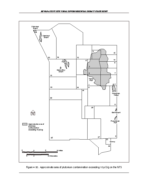
A.3.1.3 Industrial Sites Project.
The Industrial Sites Project consists of 306 Corrective Action Units which are in turn comprised of 926 Corrective Action Sites Corrective Action Units located at the NTS and Tonopah Test Range. The Corrective Action Units have been functionally grouped into source groupings. Source groupings provide an efficient mechanism to plan environmental restoration activities at Corrective Action Units with similar characteristics. The twelve source groupings are: Disposal Wells—Machine drilled boreholes of various diameters for the disposal of liquid or solid waste. Inactive Tanks—Aboveground storage tanks, underground storage tanks and the surrounding soils potentially containing petroleum products or other hazardous constituents. Contaminated Waste Sites—Generally sites with waste piles of solid material. Septic Tanks and Lagoons—Impoundments, sewage lagoons, or septic tanks designed to handle wastewater from a variety of facilities. Tunnel Ponds and Muckpiles—Muckpiles are generally heterogeneous solid wastes derived from postshot activities after an underground nuclear test in a tunnel. The solid waste is placed near the entrance to the tunnel. Tunnel ponds are impoundments created to contain contaminated meteoric waters flowing from the tunnel portals. Drains and Sumps—Informally known as "french drains," these sites are comprised of vertical borings, backfilled with gravel, and receive liquid wastes, usually from an underground pipe connected to a facility. Ordnance Sites—A site containing hazards from unexploded ordnance. Bunkers, Chemicals and Material Storage Sites— Generally a structure which housed hazardous or radioactive materials. Spill Sites—An area of soil contamination not associated with a fixed facility. Part A Sites—Comprised of the seven original Resource Conservation and Recovery Act sites listed in the hazardous waste permit for the NTS. These sites are briefly discussed later in this section. Decontamination and Decommissioning Facilities— Mission related surplus facilities which may be contaminated from usage are generally confined to the structural boundaries of the facility (i.e., floor, walls, roof). Miscellaneous Sites—Sites that do not fit the above categories of source groupings. Within the context of the Federal Facility Agreement and Consent Order, activities at Corrective Action Units within the source groupings will follow the following sequence: 1) Preliminary Assessment, 2) Corrective Action Investigation, 3) Corrective Action, and 4) Closure. If enough process knowledge and data are available at a site, a Streamlined Approach For Environmental Restoration Plan would be written to streamline this process. The Streamlined Approach For Environmental Restoration Plan would replace the Preliminary Assessment and the Corrective Action Investigation Plan. This sequence does not apply to the "Part A Sites" source grouping. These sites will be closed through the traditional Resource Conservation and Recovery Act approach in accordance with separate characterization and closure plans. The status or phase of activity for each Corrective Action Units is tracked in the Appendices to the Federal Facility Agreement and Consent Order agreement which are updated quarterly. Corrective Action Units in Appendix II are awaiting the initiation of investigative activities. Appendix III contains Corrective Action Units on which activities have been initiated. Appendix IV contains Corrective Action Units that are closed. Currently, within the Industrial Sites Project, there are 217 Corrective Action Units in Appendix II, 20 Corrective Action Units in Appendix III, and 69 Corrective Action Units in Appendix IV. Preliminary Assessment activities generally consist of historical records search, interviews with former site workers, geophysical surveys, air photo interpretation, and limited site visits or sampling activities. Corrective Action Investigations usually begin with the writing of a Corrective Action Investigation Plan. The Corrective Action Investigation Plan guides field work at the Corrective Action Units which may consist of surface soil sampling, subsurface boring sampling, or groundwater sampling. At the completion of Corrective Action Investigation activities, a Corrective Action Decision Document documents the results of the sampling activities, and explores remedial alternatives for the site. A Corrective Action begins with the writing of a Corrective Action Plan which guides the remediation of the Corrective Action Units through closure. Three Part A sites have been closed. The five sites remaining to be characterized, remediated, and closed are the Building 650 Leach field, Area 6 Steam Cleaning Effluent Ponds, Area 6 Decontamination Pond Facility, Area 2 Bitcutter Shop and Post-shot Containment Shop Injection Wells, and Area 2 U-2bu Subsidence Crater. A brief description of each site and its associated closure strategy is presented in the remainder of this section. BUILDING 650 LEACH FIELD—The Building 650 Leach field is a land disposal unit that was in operation from 1965 to October 1992. The site would be characterized in Fiscal Year 1997 and the probable closure alternative would be clean closure. Ground disturbance would be 0.034 acre. AREA 6 STEAM CLEANING EFFLUENT PONDS—The Steam Cleaning Effluent Ponds were evaporation basins used for the disposal of untreated liquid effluent discharged from the Steam Cleaning Buildings 6-621, 6-623, and 6-800. The discharges to the steam cleaning effluent ponds were discontinued in June 1993. They are currently being characterized and would be scheduled for closure in Fiscal Year 97. The probable closure alternative for this site would be clean closure; clean closure requires removing the waste-impacted soils. About 0.224 acre of ground would be disturbed. AREA 6 DECONTAMINATION POND FACILITY—The Decontamination Pond Facility was used for the disposal of untreated liquid effluent discharged from Buildings 6-605 (decontamination facility) and 6-607 (industrial laundry). The Decontamination Pond Facility is scheduled for characterization in Fiscal Year 1996 and is scheduled for closure in Fiscal Year 1997 and the probable closure alternative for this site would be closure in place. Approximately 0.0046 acre of ground would likely be disturbed. AREA 2 SHOPS—The Bitcutter Shop (constructed in 1981) and Post-shot Containment Shop Injection Wells (constructed in 1963) in Area 2 were used to dispose of hazardous wastes from steam cleaning operations. This site is scheduled for closure in Fiscal Year 96. The proposed closure alternative would be closure in place. Approximately 1 acre of land would be disturbed. AREA 2 U-2BU SUBSIDENCE CRATER—The U-2bu subsidence crater in Area 2 was created by an underground test in 1971 and was used as a land disposal unit from 1973 to 1988. Site characterization and closure are pending. The site would most likely be closed in place, which would consist of covering and sealing. About 1 acre of land would likely be disturbed. All five Resource Conservation and Recovery Act industrial sites would be scheduled for closure and/or continuation of postclosure monitoring activities through Fiscal Year 2005. Approximately 2.5 acres of land would be disturbed by these activities. It is estimated that Resource Conservation and Recovery Act sites would generate about 3,720 m3 (130,000 ft3) of mixed waste and 310 m3 (10,900 ft3) of hazardous waste over the next 10 fiscal years (1996 to 2005). The total projected funding/cost of this project is estimated to be slightly over $55 million during that same time period.
A.3.1.4 Decontamination and Decommissioning Project.
The decontamination and decommissioning facilities activity was established in 1978 to provide safe caretaking (surveillance and maintenance) and disposition (decommissioning) of retired, DOE-owned or -sponsored nuclear facilities that were used to support the development of nuclear power and nuclear weapons. Since 1989, the Assistant Secretary for Environmental Restoration and Waste Management has had responsibility for decontamination and decommissioning. The decontamination and decommissioning project in Nevada is part of the Nevada Environmental Restoration Project, which is administered by the DOE/NV Environmental Restoration Division. Decontamination and decommissioning are concerned with the safe caretaking of surplus nuclear facilities until their entombment, dismantlement/segmenting and removal, or conversion to another nonnuclear reuse. Decontamination and decommissioning tasks encompass (1) surveillance and maintenance,(2) assessment and characterization, (3) environmental review, (4) engineering design, (5) decontamination and decommissioning operations, (6) waste disposal, and (7) closeout. The inventory of surplus facilities includes reactors, laboratory facilities, and storage areas with radioactive and hazardous materials. Currently, there are seven facilities included in the NTS decontamination and decommissioning project: (1) EPA Farm, (2) Engine Maintenance Assembly and Disassembly Facility, (3) Reactor Maintenance Assembly and Disassembly Facility, (4) Test Cell A, (5) Test Cell C, (6) Pluto Disassembly Facility, and (7) Super Kukla Reactor Facility. An eighth facility, the Jr. Hot Cell, was decommissioned in Fiscal Year 1995. It has been assumed that the structures associated with all of the facilities would be demolished to ground level after verification that radioactivity levels are below the action level. No monitoring after this verification is anticipated; however, until the demolition and disposal of the waste occurs, all monitoring and security regulations would be enforced. It should also be noted that decontamination and decommissioning apply only to structures. Soils, if contaminated, would be remediated under Environmental Restoration Program activities. Demolition and waste removal would be the principal physical activities, and it is anticipated that these seven facilities would be decontaminated and decommissioned over the 10-year timeframe covered by this EIS. The seven decontamination and decommissioning project facilities contain approximately 12,100 m2 (165,000 ft2) of building area. The total projected funding/cost (1994 dollars) of these activities over the 10-year timeframe is estimated at less than $5 million. An estimated total of 37 m3 (1,300 ft3) of low-level waste would be generated between Fiscal Years 1996 and 2005.
A.3.1.5 Defense Nuclear Agency Industrial Sites.
The Defense Nuclear Agency operates as a tenant activity at the NTS under a Memorandum of Understanding with the DOE. The terms of the Memorandum of Understanding require that the Defense Nuclear Agency comply with all DOE environment, safety and health, and qualityassurance orders (DOE Orders 5820.2A and 5400.1) that require an integrated waste management plan for the NTS. The Defense Nuclear Agency, funded by the DoD, is a Work for Others Program. All the remaining activities in the program are environmental restoration related. Consequently, the Defense Nuclear Agency project description is located in the environmental restoration section of this EIS. The Defense Nuclear Agency primarily conducted its underground nuclear weapons effects tests in tunnels within Rainier Mesa located in the north-central portion of NTS in Area 12. Most of the approximately 100 sites included in this project are within Area 12. The 100 sites include muck piles, tunnel ponds, contaminated tunnel portal areas, drums, batteries, and lead materials that are or may be identified as the responsibility of the Defense Nuclear Agency. The Defense Nuclear Agency would be responsible for this project and costs. The activity envisioned for all sites would include characterization, remediation, and/or closure. Presently, the costs of restoration activities are estimated to be $15 million (1994 dollars); the restoration activities would take place between Fiscal Years 1996 and 2005. Approximately 500 acres of land would be involved, and about 50,000 m3 (1.8 x 106 ft3) of low-level mixed wastes would be generated.
A.3.1.6 Tonopah Test Range.
There are 43 source units (environmental restoration sites) identified within the Tonopah Test Range. All sites are on controlled-access lands. For the purpose of this EIS, potential release sites at the Tonopah Test Range were divided into seven categories: (1) underground storage tanks, (2) landfill and lagoons-01, (3) landfill and lagoons-02, (4) soil contamination sites, (5) surface and near-surface radioactive sites, (6) ordnance sites, and (7) photographic french drains. UNDERGROUND STORAGE TANKS—Four potential release sites are identified under the underground storage tank category. The anticipated activity would include characterization, contaminated soil removal, and site closure. The sites are located in Area 3. LANDFILL AND LAGOONS-01—The landfill and lagoons-01 category consists of four potential release sites. Capping and monitoring are the anticipated activities. The sites are located in Areas 3 and 9. Capping and monitoring well-installation activities are estimated to begin in 1999. Approximately 20 acres would be disturbed as a result of these activities. LANDFILL AND LAGOONS-02—This category consists of two potential release sites. The anticipated activities include characterization, remediation, and closure of the landfill and lagoon. Approximately 5 acres within the Tonopah Test Range would be affected. Monitoring activities are not anticipated upon completion of the remediation and closure of the sites. SOIL CONTAMINATION SITES—Twenty potential release sites are included in this category. The sites are primarily located in Areas 3 and 9. The anticipated activities include characterization, remediation, and closure. Approximately 5 acres of land would be disturbed. SURFACE AND NEAR-SURFACE RADIOACTIVE SITES—Seven potential release sites are included in this category. The anticipated activities are characterization and remediation (soil and debris removal). The combined total of disturbed land for the 7 sites is estimated to be 50 acres. ORDNANCE SITES—Three potential sites are included in this category; the anticipated activities include ordnance removal or detonation, characterization, remediation, and closure. The units are all located within the Tonopah Test Range. The ordnance sites are no longer in use; however, one of the sites is directly along the active Tonopah Test Range flightpath. Ordnance tests are occasionally performed along the flightpath. Activities may affect up to 1,000 acres (buffer area is 50,000 acres). PHOTOGRAPHIC FRENCH DRAINS—This category consists of two potential release sites located in Areas 3 and 9. Approximately 0.5 acres of land may be disturbed. Over the 10-year timeframe of this EIS, approximately 960 m3 (33,900 ft3) of low-level waste would be generated from this project. About 16,600 m3 (587,300 ft3) of hazardous waste would also be generated in the same 10-year time period.
A.3.1.7 Central Nevada Test Area.
The Central Nevada Test Area is located approximately 92 km (57 mi) northeast of Tonopah in south-central Nevada. Project Faultless was the only nuclear (underground) test at this site (the test occurred on January 19, 1968). The device was detonated 975 m (3,200 ft) belowground surface. No venting of particulate debris occurred during or after the explosion. Several environmental restoration sites have been identified within the Central Nevada Test Area. Some of these sites consist of abandoned mud pits that are contaminated with heavy metals and petroleum hydrocarbons. Other industrial sites are also included within the Central Nevada Test Area; these may include sewage lagoons, trash dumps, 2 emplacement holes, an uncovered 9 m (30 ft) deep hole in the ground, and a runoff ditch. The activities to be conducted are site characterization, appropriate remediation and long-term hydrologic monitoring. The deep subsurface environments would likely remain restricted for an indefinite period of time.
A.3.1.8 Project Shoal Area.
The Project Shoal Area is located approximately 48 km (30 mi) southeast of Fallon, Nevada and covers a 10 km2 (4 mi2) area. The underground nuclear test at the Project Shoal Area occurred October 26, 1963. The device was detonated 411 m (1,350 ft) below ground. No venting of particulate debris occurred during or after the explosion. Deactivation of the site commenced almost immediately with all surface equipment removed by January 31, 1964, and the site was placed on standby status. Future activities would likely include continuing the site characterization, appropriate remediation, and long-term hydrologic monitoring. The DOE's long-term strategy for the Project Shoal Area is for unrestricted use of surface land. The deep subsurface environments would likely remain restricted for an indefinite period of time.
A.3.2 Alternative 2
In Alternative 2, Environmental Restoration Program activities would be discontinued, and sites would be left abandoned as is. All reports, studies, field investigations, characterization, and decommissioning and/or decontamination would cease. Environmental monitoring would continue to the extent necessary to detect contaminant migration at compliance boundaries. All remediation projects under way would be discontinued, with the goal of progressing to a suitable conclusion within one calendar year of the decision to pursue this alternative.
A.3.3 Alternative 3
In Alternative 3, Environmental Restoration Program activities would continue as identified in Alternative 1. Most Environmental Restoration Program activities are expected to be accelerated relative to Alternative 1. Expanded uses may require cleanup level adjustment in accordance with the applicable environmental requirements.
A.3.4 Alternative 4
Environmental Restoration Program activities would continue at current or accelerated rates. Cleanup levels and/or remediation could be stricter (where applicable), based on designated land use and/or the potential return of some lands to the public domain.
A.4 Nondefense Research and Development Program
The DOE has historically supported a variety of research and development activities at the NTS in cooperation with universities, industry, and other federal agencies. The nondefense research and development projects, activities and business services evaluated in this EIS are described below.
A.4.1 Alternative 1
Under this alternative, the DOE would continue to support the ongoing Nondefense Research and Development Program operation.
A.4.1.1 Alternative Energy.
Southern Nevada represents an ideal place for the research and development of a variety of alternative energy resources. Principal among these is solar-power electrical production. The abundance of this resource, coupled with the available land and existing labor forces, presents a significant opportunity for demonstration and development of large-scale solar energy systems with the potential for commercial success. A Solar Enterprise Zone facility concept has been advanced by a consortium of federal, state and local entities along with the solar power industry. Established through an open, public process, the collective effort is to develop, finance and construct one or more solar power production plants in southern Nevada. Up to 1000 MW has been considered as a long-term goal starting with a 100 MW project solicitation. Four sites, including the NTS, are currently being considered for construction of the initial solar generation facilities. Additional sites may be considered to support the long-term goals of a Solar Enterprise Zone facility initiative. The Corporation for Solar Technology and Renewable Resources was created in early 1995 to facilitate the mission and goals of a Solar Enterprise Zone facility. It is a non-federal corporation established specifically to implement the action plans of a Solar Enterprise Zone facility. The actual cost of construction of a solar project on one or more of the sites considered will be financed by the project developers who may have access to tax exempt bonding through the Corporation for Solar Technology and Renewable Resources. The DOE is not expected to hold equity interest in the facilities actually constructed.
A.4.1.2 Spill Test Facility.
The DOE Spill Test Facility is a research and demonstration facility. It is available on a user-fee basis to private and public sector test and training sponsors who are concerned with the safety aspects of hazardous chemicals. Safety research associated with the handling, shipping, and storage of hazardous fluids and liquefied gaseous fuels is conducted within this facility. The Spill Test Facility is the only facility of its kind for either large- or small-scale testing ofhazardous and toxic fluids, including wind tunnel testing, under controlled conditions. The facility consists of a control building, a wind tunnel, meteorological and camera towers, a tank farm and spill area, and a personal safety equipment building. The site is composed of four test areas. Since 1986, the Spill Test Facility has been used for evaluating and modeling hazardous releases into the atmosphere. The facility is ideally suited for test sponsors who wish to develop verified data on prevention, mitigation, cleanup, and environmental effects of toxic and hazardous gaseous liquids. In addition to testing, the facility provides structured training for emergency spill response for most chemicals in commercial use. Performing controlled, measured releases of toxic and hazardous materials into the environment is the most reliable means of simulating the behavior of these chemicals during a full-scale accidental release. The Spill Test Facility is located on Frenchman Flat at the NTS, approximately 121 km (75 mi) northwest of Las Vegas, Nevada. To date, six environmental assessments and associated Findings of No Significant Impact spanning 1981 to 1994 have been written to cover the testing of certain chemicals at the Spill Test Facility. Specific tests proposed to be conducted at the Spill Test Facility must be assessed by the DOE in an addendum to the Environmental Assessment for Hazardous Materials Testing at the Liquefied Gaseous Fuels Spill Test Facility (DOE/OFE, 1994) according to predefined exposure limits or bounds for testing. If these tests are determined to be within the bounding analysis of the aforementioned environmental assessments, the DOE issues a Findings of No Significant Impact for that specific test. The Spill Test Facility is already permitted for the release of 30 gases. Operations would continue at the Spill Test Facility at its present level of testing. Through the enactment of the Clean Air Act Amendments of 1990, Congress has directed the EPA and the DOE to oversee experimental research and to develop a list of chemicals and a schedule for testing at the Spill Test Facility. Specifically, Section 103(f) of the Clean Air Act specifies that a minimum of two chemicals per year should be field tested at thefacility, with priority given to chemicals presenting the greatest potential risk to human health. The Act requires the DOE to make the facility available to interested persons, including other federal agencies wanting to conduct related research and activities.
A.4.1.3 Alternative Fuels Demonstration Projects.
Executive Orders 12759 and 12856, the Energy Policy Act of 1992, and the Clean Air Act mandate the general requirements for using alternative fuels in the federal and private sectors and establish baseline conversion tables and procurement schedules for new alternative-fueled vehicles. Although the NTS does not have the refueling infrastructure to support alternative-fueled vehicles, the DOE has converted 16 of its vehicles to compressed natural gas. These vehicles would be stationed in Las Vegas and shuttle between the Nevada Operations Office and the NTS. This initiative used Fiscal Year 1994 funding; additional funding is anticipated once the costs for procurement and conversion of original-equipment-manufacturer vehicles is developed in a formal proposal. It is anticipated that initial refueling requirements to support future compressed natural gas conversions at the NTS might consist of tanker refueling deliveries until the demand establishes the need for permanent facilities. Without future funding availability for refueling infrastructure, further conversion activity for the remaining vehicle fleet would be unlikely. The intent is to build the infrastructure, convert the original fleet, and further develop partnerships geared to study other alternative fuel and energy sources, including, but not limited to, fuel-cell research and development, exotic-fuels development, additive research, and electric-automobile development and use. Under Alternative 1, the DOE would continue to support the 16 DOE-owned vehicles already converted to compressed natural gas. The DOE would also continue developing a formal proposal for the conversion of the original-equipment-manufacturer vehicles fleet. However, no conversion would take place beyond the development of a formal proposal.
A.4.1.4 Environmental Management and Technology Development Project.
The DOE is committed to improving the effectiveness of all of its programs and organizations. In support of this commitment, the Office of Environmental Management Program, in cooperation with other DOE research organizations, will use the best science and technology available to solve the most challenging set of environmental problems in the world. This approach will build upon existing programs and will seek continual improvement of all environmental management operations and processes. The goal of environmental management and the Technology Development Office is to conduct a research and technology development program that is focused on overcoming major obstacles to progress in cleaning up the DOE sites and that involves the best talent in the DOE and the international science communities. The focus of the Technology Development Project is on five major remediation and waste management areas:
- Contaminant Plume Control and Remediation
- Mixed Waste Characterization, Treatment, and Disposal
- High-Level Tank Remediation
- Landfill Stabilization
- Facility Transitioning, Decommissioning, and Final Disposition.
- Management Team
- Implementation Team
- Focus Area Review Group
- Site Technology Coordination Groups (DOE).
- Field demonstration of the associated particle imaging system, a nonintrusive technology for three-dimensional, elemental characterization of sealed, or inaccessible, containers and structures. This system would be used for decontamination and decommissioning activities
- Field demonstration of airborne and hand-held, laser-induced fluorescence systems for decontamination and decommissioning application. This system is particularly useful for characterizing depleted uranium contamination, as well as for petroleum products
- Implementation of improved techniques for integrating remote sensing data into geographic information systems.
A.4.1.5 Environmental Research Park.
The National Environmental Research Park Program was started in 1972 by the DOE in response to recommendations by citizens, scientists, and members of Congress to set aside land for ecosystem preservation and study. Seven such ecosystem sanctuaries have been established, the latest of which is the NTS in 1992. Under a cooperative agreement between the DOE/NV, the University of Nevada and the University of Nevada, Las Vegas, the DOE/NV Office of the Assistant Manager for Environmental Restoration and Waste Management is providing financial assistance to the University of Nevada, and the University of Nevada, Las Vegas, to conduct scientific research projects unique to the NTS Environmental Research Park. Areas of research include, but are not limited to, habitat reclamation, hydrogeologic systems, radionuclide transport, ecological change, waste management, monitoring processes, remediation, and characterization. Projects are selected by the park director from annually submitted proposals. Existing projects and new projects will be conducted in accordance with this agreement. The number of projects conducted is commensurate with the available budget, the infrastructure, and the functions in place to support the projects. In addition, scientific research projects conducted by parties other than those in the above-mentioned agreement are being conducted, and more are anticipated. These parties are funded from sources other than the DOE/NV. The number of projects is limited only by the infrastructure and functions in place to support the projects. The current infrastructure and facilities operable at the NTS, and perhaps even in a reduced capacity, are sufficient to support the park.
A.4.2 Alternative 2
Under this Alternative, the DOE would discontinue support of ongoing program operations.
A.4.3 Alternative 3
Under Alternative 3, the DOE would continue to support the ongoing activities described under Alternative 1 and pursue new initiatives.
A.4.3.1 Alternative Energy.
A Solar Enterprise Zone facility concept is being advanced by a consortium of federal, state, and local entities along with the solar power industry. Established through an open, public process, the intent of this effort is to develop, finance, and construct one or more solar power production plants in southern Nevada. The Corporation for Solar Technology and Renewable Resources has headed this effort and was created in early 1995 to facilitate the mission and goals of a Solar Enterprise Zone facility. The actual cost of constructing a solar power project on one or more of the sites considered will be financed by the project developers who may have access to the tax exempt bonding through the Corporation for Solar Technology and Renewable Resources. Costs or profits generated from the development of solar technologies will be realized by the project developers, and the Corporation for Solar Technology and Renewable Resources, not the DOE. Impact analyses for Solar Enterprise Zone facility activities presented in this EIS were based on the worst case scenario which maximized disturbed land and water use. The worst case scenario analyzed was one which assumed a single 1,000-MW facility disturbing 2,400 acres of land, and using solar technology which required 5,550 acre-feet/year of water. Also included in the land disturbance analysis was the construction of additional power lines and natural gas pipe lines required for the facilities. Power lines and pipe lines to Las Vegas were assumed to disturb 2,182 acres of land for a six-month period. It is important to note, however, that specific sites and/or technologies have not yet been chosen and may affect this scenario. Additional National Environmental Policy Act documentation may be required before the construction of Solar Enterprise Zone facilities begins. The documentation will contain the latest pertinent data to provide decisionmakers with up-to-date information regarding the Solar Enterprise Zone facilities initiative, including possible disturbances resulting from the installation of power lines or pipe lines. The private corporation implementing the solar technology(ies) would bear the burden of performing the additional analysis and of mitigating any adverse effects realized by these activities. Photovoltaic systems convert solar radiation to direct-current electricity without moving parts or thermal energy sources. The solar cell contains a semiconductor material, the most common of which is silicon, that typically produces about 100 watts ofdirect current power per square meter. Commercial solar modules convert between 11 to 13 percent of incident sunlight into electricity unless mounted on a tracking system that can increase output by 20 percent or more. Parabolic-trough solar thermal systems use parabolic mirrors shaped to concentrate insolation on a receiver tube along the focal line of the trough. The heat generated by the concentrated sunlight is transferred to a working fluid, which is transferred through insulated pipes to a heat transfer device used to raise steam. The steam is then used to power a steam turbine and produce electricity. This technology also incorporates the use of natural gas as a back-up system. Power tower systems consist of fields of heliostats that focus solar radiation on a power tower. The receiver absorbs the heat energy and transfers it to a circulating fluid that can either be stored or used directly to produce power. Parabolic dish systems are point-focus devices that use a parabolic mirror to focus solar energy on a single receiver located at the focal point of the dish. The heat is then absorbed in a fluid, which can then be converted to electricity via a generator system located at the focal point of the dish or be piped to a central location for electricity generation or thermal applications. Systems coupled with engine generators at the focal point have the greatest potential to produce electrical energy. The location of a large-scale solar-power production facility at the NTS would require upgrades to the existing transmission infrastructure. The NTS power transmission system could support 100 MW of capacity with no additional investment in upgrading the system; approximately 30 MW is used by the NTS, and the remaining 70 MW would be available for export. In order to handle the planned 1,000 MW capacity, power transmission lines would have to be upgraded to between 345 kilowatts (kW) and 500 kW from the NTS to Southwest Intertie or Eldorado Valley near Las Vegas. Other infrastructure upgrades required for the siting of the solar production facility at the NTS may be a natural gas line and/or water system improvements, as determined by the type of technology used. Alternatively, other sites may be used in conjunction with the NTS to support a Solar Enterprise Zone facility initiative to minimize infrastructure improvement requirements and improve access to power markets. Additional sites in southern Nevada have been proposed for deployment of a Solar Enterprise Zone facility. The Eldorado Valley, south of Boulder City, the Dry Lake Valley (Apex/Harry Allen) site, and the Coyote Spring Valley in Lincoln County, are alternative southern Nevada locations being considered for a Solar Enterprise Zone facility development. Six thousand acres of land in Eldorado Valley recently annexed by the city of Boulder City has been designated for the purpose of renewable resource development. Eldorado Valley lies in the center of the southwestern power transmission system that links the power markets of Arizona, Utah, southern Nevada, and southern California, providing unparalleled access to transmission and utility markets. Consequently, Eldorado Valley is the most likely marketing location for power generated at any of the sites being considered for a Solar Enterprise Zone facility development. Natural gas and water transmission systems would need to be developed before this area could employ hybrid solar technologies or any solar-energy production systems requiring water. Two natural gas pipe lines transect this area, and depending on the siting of solar facilities in this area, the gas line could be from 2 to 10 km (1 to 6 mi) away. There is very little groundwater in this area; however, the city of Boulder City has indicated an interest in making available up to 3.7x10⁶ m3/yr (3,000 ac ft/yr) of treated effluent to support solar development of this area. This amount of water would be sufficient to support a 300 MW solar-powered steam facility. The Nevada Power Company's Harry Allen site is located about 32 km (20 mi) northwest of Las Vegas, just north of Interstate 15 in the Apex industrial area. Nevada Power Company has identified 3,600 acres for development of renewable energy supply. Currently, the area has a power transmission capacity of 305 MW, but plans of the Nevada Power Company to site 280 MW of gas combustion turbines would seriously limit the transmission availability for development of solarpower. Infrastructure improvements being considered for the area include the termination of a major line for Idaho and completion of the Sunrise Corridor project, which could expand the transmission capability of the Harry Allen site. Also, a natural gas pipe line is currently being arranged between the Nevada Power Company and gas pipe line companies. These improvements could be completed in time for Solar Enterprise Zone facility development. Water supply is very limited in this area, and there are no plans to construct a permanent water supply line to this area; Nevada Power plans to truck water to support its combustive turbines. The Coyote Spring Valley site is located approximately 93 km (58 mi) north of Las Vegas. Site boundaries fall within both Clark and Lincoln counties and have 3,200 acres of land available for solar power development. The property is currently owned by Aerojet Investments, Ltd. The Lincoln County Power District owns and operates the existing transmission system, which runs along the western border of the Aerojet property. The existing system is capable of accommodating 35 MW of solar generated power. Providing water to a solar facility on site would require either drilling or a new well or transporting water from an off site location. The closest supply of natural gas is 47 km (29 mi) to the east where a Southwest Gas pipe line is located.
A.4.3.2 Spill Test Facility.
Activities would be similar to those described under Alternative 1, but the level of activity would be increased.
A.4.3.3 Alternative Fuel Demonstration Projects.
Activities would be the same as those described under Alternative 1, with two exceptions. Under Alternative 3, the DOE would construct a compressed natural gas fueling facility for compressed natural gas vehicles at the NTS. In addition, the DOE would further develop partnerships geared to study other alternative fuel and energy sources.
A.4.3.4Environmental Management and Technology Development Program.
Under Alternative 3, the technology development activities would increase in all areas. Those activities listed as proposed under Alternative 1 would be implemented. As a national resource for the management of mixed waste, the DOE/NV would develop and refine waste-management monitoring methods. In Alternative 1, the DOE would convert vehicles to and use compressed natural gas. Under Alternative 3, any vehicle or fueled equipment associated with DOE/NV work activities may be evaluated as to their potential conversion to alternate fuels. In addition, alternate fuels and associated technologies other than compressed gas may be evaluated, tested and demonstrated. Alternate fuel systems that may be considered include electric vehicles (powered by fuel cells or batteries), superconducting magnetic levitation vehicles, and vehicles with internal combustion engines running with alcohol-based fuels (methanol and ethanol), gaseous fuels (compressed or liquefied natural gas and liquefied petroleum gas), and non-conventional fuel mixtures (such as hydrogen and oxygen). In February 1996, the DOE initiated a joint team with NTS Development Corporation, a DOE community re-use organization, and Kistler Aerospace Corporation. The DOE supports, as part of the increase in technology development activities at the NTS, the Kistler Aerospace Corporation's proposal for a commercial satellite delivery service as a potential future activity under this program. The DOE considers this activity compatible with the existing and future uses of the NTS. Kistler identified in the public comment process on the Draft NTS EIS their proposal to manufacture and operate an aerospace vehicle for the delivery of communications satellites to low earth orbit at the NTS. Specific activities may include the fabrication of composite structures, vehicle assembly, processing, fueling, and recovery. Kistler anticipates conducting three suborbital test flights and three orbital test flights in the first year of operation, followed by an anticipated two operational flights per month after the test phase.
A.4.3.5 Environmental Research Park.
Activities would be the same as those described under Alternative 1.
A.4.4 Alternative 4
In some cases under this alternative, activities would be the same as those described under Alternative 1. In other cases, activities would be the same as those described under Alternative 3.
A.4.4.1 Alternative Energy.
Activities would be the same as those described under Alternative 3.
A.4.4.2 Spill Test Facility.
Activities would be the same as those described under Alternative 1.
A.4.4.3 Alternative Fuels Demonstration Projects.
Activities would be the same as those described under Alternative 1.
A.4.4.4 Environmental Management and Technology Development Program.
Activities would be the same as those described under Alternative 3.
A.4.4.5 Environmental Research Park.
Activities would be the same as those described under Alternative 1.
A.5 Work for Others Program
The Work for Others Program is hosted by the DOE and includes the shared use of certain NTS and Tonopah Test Range facilities and resources with other federal agencies, such as the DoD for various military training exercises and research and development projects.
A.5.1 Alternative 1.
Under Alternative 1, the DOE would continue to host the projects and activities of other federal agencies at activity levels not exceeding those of the past 3 to 5 years.
A.5.1.1 Treaty Verification.
Activities at the NTS and NTS support facilities throughout Nevada, including the Tonopah Test Range, have been, and will continue to be, impacted by implementation of current and future international arms control treaties. Principal responsibility for implementing and coordinating the DOE/NV arms control activities is assigned to the Emergency Management and Nonproliferation Division. The DOE/NV Safeguards and Security Division shares responsibility and may actually take the lead for those activities that are principally overflights or walk-through inspections of short duration and are nonoperational in nature. Treaties currently in effect or under negotiation and the relevant rights granted under those treaties are discussed below. The negotiation of a Comprehensive Test Ban Treaty is underway at the Conference on Disarmament in Geneva, Switzerland. The DOE/NV is conducting various projects for the DOE Headquarters to help develop a strong, verifiable treaty that will deter proliferant activities.
A.5.1.1.1 Threshold Test Ban Treaty
—The Threshold Test Ban Treaty permits Russian scientists and engineers to conduct an inspection of one nuclear test per calendar year if tests were conducted. The purpose of the inspection is to verify that the United States is in compliance with treaty limits.
A.5.1.1.2 Peaceful Nuclear Explosion Treaty
— Russian scientists and engineers would conduct inspections and geophysical measurements of any peaceful nuclear explosions at the NTS. However, the United States has no plans to conduct peaceful nuclear explosions, so this treaty would have no effect on the NTS related sites or facilities.
A.5.1.1.3 Chemical Weapons Convention
—The Chemical Weapons Convention Treaty provides for on-site inspections of the United States' facilities capable of manufacturing or storing chemical weapons. Although the NTS has not been used for the production or storage of treaty-limited chemical agents, the presence of operations, such as the Spill Test Facility, may be sufficient justification to trigger challenge inspections under terms of the Chemical Weapons Convention.
A.5.1.1.4 The Treaty on Open Skies
—In an effort to promote openness and to facilitate monitoring of arms control treaties, the Treaty on Open Skies provides for aerial inspections by foreign observers of virtually any site in the United States, including those sites that might be engaged in the production, testing, or storage of treaty-limited weapons systems. Periodic inspections of the NTS facilities are expected as this treaty is implemented.
A.5.1.2 Nonproliferation.
The policy of the United States is to resist the proliferation of weapons of mass destruction. These weapons cause indiscriminate, widespread destruction and include nuclear, biological, and chemical weapons. Nonproliferation can be defined as the use of the full range of political, economic, and military tools to prevent proliferation, reverse it diplomatically, or protect the United States' interests against an opponent armed with weapons of mass destruction should that prove necessary. Nonproliferation tools include intelligence, global nonproliferation norms and agreements, diplomacy, export controls, security assurances, defenses, and the application of military force. The NTS and Tonopah Test Range continue to provide critical support for the United States' nonproliferation goals and objectives, particularly in the areas of research and technology development. In the past, seismic signatures and ground disturbances produced from underground nuclear weapons tests at the NTS have been analyzed to develop techniques and methods for detecting and evaluating underground nuclear tests worldwide. Additional nonproliferation-related experiments are currently using the unique capabilities of the Spill Test Facility for the development, characterization, and testing of remote sensors of chemical effluent.
A.5.1.3 Counterproliferation Research And Development
. Counterproliferation refers to the DoD efforts to combat the international proliferation of weapons of mass destruction. As with nonproliferation, these efforts include the full range of political, economic, and military tools available. However, since facilities for developing, producing, and storing weapons of mass destruction are likely to be located belowground, a considerable amount of counterproliferation research and development involves the detection, monitoring, and neutralization of buried targets. The tunnels and bunkers at the NTS provide ideal testing environments for a variety of counterproliferation research and development experiments. Experiments that use various remote imagery and sensory applications in conjunction with NTS bunkers and tunnels are conducted to develop techniques and methods to detect, characterize, and monitor buried objects. Such experiments involve both land-based and airborne operations. Experiments to develop various techniques for destroying or neutralizing weapons of mass destruction and buried objects, such asbunkers and tunnels, are also performed. These experiments involve the surface and belowground detonation of conventional explosives in the immediate vicinity of the NTS and Tonopah Test Range bunkers and tunnels. The NTS could become the center for a national counterproliferation program. This program would integrate the Nevada-based military and U.S. Bureau of Land Management ranges into a national counterproliferation test bed, with the NTS at its center. This test bed would be used for a variety of research and technology development experiments aimed at countering the proliferation of weapons of mass destruction. The Big Explosives Experimental Facility was specifically designed as a hydrodynamic testing facility for the research, development, and testing of counterproliferation technologies. Modern United States nuclear weapons contain sophisticated safety features and are small in size relative to the first nuclear weapons, making their disablement straight forward and certain. Proliferant countries and terrorist organizations, on the other hand, are likely to produce nuclear weapons that are unstable and, therefore, difficult to render safe with certainty. Several promising technologies have been proposed and are under development to counter the special problems associated with this more primitive class of nuclear device. In order for these technologies to be successfully developed, a facility must be available to test the hydrodynamic functioning of simulated nuclear devices containing large amounts of conventional high explosives. The Big Explosives Experimental Facility is crucial for this task given the absence of underground nuclear testing. This is the main purpose of Big Explosives Experimental Facility (see Appendix F ). The Dipole Hail Project involves a series of tests to evaluate the effectiveness of various techniques and munitions in damaging tunnels and thereby impairing nuclear weapons development operations in those tunnels. The Cut and Cover Project involves using unattended ground sensors to identify and distinguish remotely between various types of equipment being operated in bunkers.
A.5.1.4 Conventional Weapons Demilitarization.
By the year 2000, it is expected that the United States government will need to dispose of over 4.5 x 10⁷ kg(1.0x10⁸ lb) of solid rocket motors. In addition, the United States government is currently the custodian of over 200,000 tons of obsolete conventional munitions and pyrotechnics (Joint Ordnance Commanders Group, 1995a). There is a definite need to disposition these obsolete munitions and ordnance in a safe, environmentally sound, and economical manner. The demilitarization activity proposed for the NTS is a demonstration of potential technologies used to destroy obsolete conventional munitions, pyrotechnics, and solid rocket motors by testing the technologies. Any future, large-scale activity involving the demilitarization of obsolete munitions would require additional National Environmental Policy Act Review and would be subject to all other applicable federal, state, and county regulations as well as permitting requirements. The existing underground tunnels and facilities at the NTS offer a unique opportunity to demonstrate environmentally sound methods of destruction/treatment of solid rocket motors, pyrotechnics, and other non-nuclear energetic materials by using specially designed pollution abatement systems that remove the gaseous combustion products from the air prior to atmospheric release and provide for containment/treatment of residual debris. The Spill Test Facility in Area 5 would suffice for the demonstration of the thermal treatment technologies for pyrotechnics, and a tunnel environment at the NTS would suffice for the demonstration technologies involving solid rocket motors and other conventional munitions. Using an NTS tunnel takes advantage of a known geologic cavern as well as the expertise of the NTS workforce in tunnel handling and firing of high explosives and in monitoring explosives in a contained environment. Research indicates that X tunnel would suffice for demonstration projects involving destruction/treatment of solid rocket motors and conventional munitions. Calculations would be made to determine pressure and temperature, as well as other effects, which would then be applied to design basis documentation and a test plan. The tunnel would be modified with containment plugs, monitoring instrumentation, containment valves, and scrubbing and sampling outlets. All environmental requirements would be met, and all environmental, safety, and health protection precautions would be taken. The demonstration would consist of transporting a solid rocket motor or conventional munition from off site to an underground cavern. The plugs and bulkheads would be closed, and with instrumentation fully established and calibrated, the solid rocket motor or conventional munition would be detonated from a remote location. Gases would be sampled before and after scrubbing in preparation for ventilation. The goals of the technologies are to develop "...an optimized demilitarization research and development demonstration capability at the NTS, a set of fully characterized demonstrations of environmentally benign destruction or resource recovery and recycling processes, and final design packages for innovative processes" (Joint Ordnance Commanders Group, 1995b). The construction and installation phases would include facility preparation, tunnel modification, excavation, grouting, sealing, and foundation work, as well as equipment installation, startup and shakedown of equipment and procedures, and personnel training. It is estimated that the planning, design, construction, and installation phases of this activity would require the services of approximately 15 workers for 3 years, while the demonstration phase would require the services of approximately 20 workers for approximately 0.5 years. Total cost of the project is estimated at nearly $5 million.
A.5.1.5 DefenseRelated Research and Development.
In the past, defense-related research and development activities have included tests and training exercises employing weaponry, such as small arms, artillery, guns, aircraft, armored vehicles, demolitions, rockets, bazookas, and air-dropped armaments, as well as a variety of electronic, imagery, and sensory technologies, including, but not limited to, infrared, lasers, and radar. Table A-1 lists examples of recent defense-related research and development projects conducted at the NTS. It is expected that additional experiments and tests similar to those mentioned in Table A-1 , but not yet identified, would take place at the NTS.
A.5.2 Alternative 2
No Work for Others Program activities would occur at the NTS under Alternative 2 with one exception. Those activities described under treaty verification for the Treaty on Open Skies and the Comprehensive Test Ban Treaty would be the same as those described for Alternative 1. Activities at the Tonopah Test Range would be the same as those described for Alternative 1.
A.5.3 Alternative 3
Activities at the NTS and the Tonopah Test Range would be the same as those described under Alternative 1, with certain activities having a greaternumber of experiments to conduct, resulting in an expanded scope.
A.5.4 Alternative 4
Activities at the NTS would be the same as those described under Alternative 2. Additionally, there would be an increased use of the NTS airspace by the U.S. Air Force. P>Activities at the Tonopah Test Range would be the same as those described UNDER under Alternative 1.
A.6 Site-Support Activities at the NTS
Section A.6 describes the existing infrastructure and support facilities present at the NTS and supporting facilities in Clark County, Nevada. These facilities include the utilities, communications, and transportation systems, as well as the existing support facilities, both on and off site. The current and planned infrastructure projects are also described. The NTS-related employment has always depended on programmatic requirements; consequently, wide fluctuations in employee numbers can be tracked throughout the history of the NTS. Over the past 20 years, civilian personnel have numbered as many as 10,000 and as few as 4,900. The DOE/NV reported 6,576 NTS-related employees (DOE, laboratory, and contractor) in July 1995. Approximately 27 percent (1,794) of the employees work in the forward areas of the NTS, 18 percent (1,153) are based at Mercury, and 55 percent (3,629) work in Las Vegas and North Las Vegas. These figures include personnel assigned to the Yucca Mountain Project at the NTS and in Las Vegas. Currently, the Yucca Mountain Project employs 1,912 or 29 percent of the NTS-related workforce. More than half the Mercury-based workers are administrative, clerical, professional, and technical. The NTS has room accommodations for approximately 1,700 people and parking for approximately 60 recreational vehicles; however, because the majority of workers commute fromLas Vegas and other communities, the number of accommodations is adequate for the present. If nuclear testing is halted completely, the number of contractor personnel would not drop to zero. Continuing activities that must be performed would require that many personnel be retained. However, personnel idled by a complete testing halt would include the experienced and skilled scientists and technicians who drill and mine emplacement holes, emplace devices, design and install data-gathering systems, and collect and analyze test data. If this large block of talent were lost, it would take at least 3 years to locate, train, and activate a comparable test-support organization. The DOE/NV provides sites and facilities on the NTS for underground weapons testing and numerous advanced research and development projects that support the Defense Program. For off-site safety, the EPA carries out extensive radiation monitoring and dosimetry programs in areas surrounding the NTS. Projects for other federal programs are fielded on a cost-reimbursable basis. A Maintenance and Operating contractor currently operates all user-occupied facilities. Operations include construction and maintenance. The DOE/NV Nevada Test Site Office provides operations oversight of the Maintenance and Operating Contractor. The NTS is not a production facility; therefore, there are no quantities of production to report. The site work load fluctuates with the mission and depends on the funding received. Resources are periodically redistributed to maintain productivity and efficiency. Both resources and facilities are fully used by design. The NTS is used to test research and development efforts undertaken by three DOE national laboratories. Two of these laboratories, Los Alamos National Laboratory and Lawrence Livermore National Laboratory, conduct nuclear device tests. The third organization, Sandia National Laboratories, is responsible for tests of non-nuclear elements of nuclear weaponry. Other users include the U.S. Air Force, the DoD, and the Defense Nuclear Agency. These groups conduct programs that include nuclear and non-nuclearweapons-effects tests and weapons-development tests. Nonweapons users include the Yucca Mountain Site Characterization Office and the Nuclear Emergency Search Team. Support of the underground testing program requires a drilling and mining operation. The DOE/NV contractors are directly involved in these operations. The DOE/NV contractors also provide security, guard force services, operation and management of the DOE/NV centralized computer system, and auditing. The following agencies assist the DOE/NV with its testing and public safety programs:
- The U.S. Bureau of Mines conducts mine and well inspections before and after underground tests
- The U.S. Geological Survey conducts hydrological studies, including flow paths of groundwater
- The National Weather Service correlates test-area weather data with national weather information to make local preshot forecasts
- The EPA performs radiological health and safety services, including determining background radiation levels, determining extent of radiation in connection with accidental release of radioactivity, and preparing for emergency action.
- The University of Nevada's Desert Research Institute calculates groundwater migration of radioactive material resulting from underground nuclear testing.
A.6.1 Alternative 1
Existing infrastructure at the NTS and supporting facilities in Clark County are described under this alternative. This information has been obtained from the Fiscal Year 1994 Nevada Test Site Technical Site Information (RSN, 1994a) and the Fiscal Year 1996 Capital Asset Management Process Report (RSN, 1994b).
A.6.1.1 Utilities
Utilities include electrical power, natural gas, water supply and wastewater, and industrial wastes. It also includes the related distribution, transmission, treatment, and disposal systems, as appropriate, for these utilities. The personnel that maintain these utilities comprise a group of approximately 68 full-time employees at the NTS. This includes approximately 45 personnel in the electrical power group, 17 in the water and steam group, and 6 in the sanitary/solid waste group (excluding hazardous, radioactive, and mixed waste).
A.6.1.1.1 Electrical Power
—Electrical power at the NTS includes off-site and on-site power transmission systems, on-site subtransmissions, existing and projected subtransmissions, and NTS area transmission. OFF-SITE POWER TRANSMISSION—In September 1993, Raytheon Services Nevada completed an updated load-flow study, to modify the results of a 1991 load-flow study. The update was required because of the Yucca Mountain Project load reduction and program changes at the NTS. Projected loads had been reduced significantly from 71 MW to 52 MW. The proposal of a new 138 kV line from the Nevada Power Company was withdrawn; however, the addition of capacitor banks at the NTS is still necessary to provide voltage support if the Yucca Mountain Site Characterization project reaches 15 MW. ON-SITE POWER TRANSMISSION—The existing on-site power transmission system at the NTS is similar to that of a municipality. Power is procured at 138 kV at the Mercury switch station and the Jackass Flats substation and is metered at both locations by the Nevada Power Company. The option also exists to purchase power from Valley Electric Association, Inc., through transmission lines supplying 138 kV to the Jackass Flats Switching Station. The on-site power system is operated and maintained by Bechtel Nevada. The total disturbed area of the on-site power system is 1.3x10⁶ m2 (1.4x107 ft2) as shown in Table A-2 . Power at the NTS is transmitted through a 161-km (100-mi)-long, 138 kV transmission loop that supplies eight major substations and one 138 kV radial transmission line. The subtransmission of power is via an extensive 34.5 kV system and two small 69-kV systems. The 138, 69, and 34.5 kV systems provide distribution voltages of 4.16 kV and 12.47 kV at various substations. The 34.5 kV subtransmission system is also used as a distribution voltage at several remote sites. Distribution voltages are transformed to both 480/277-volt (V) and 208/120-V three-phase systems for most NTS loads with a few single-phase, 120 V services. The basic load centers served at the NTS are Mercury (Area 23) and Areas 2, 3, 6, 12, and 25. The 138 V transmission system loop runs from the Mercury (Area 23) switching station, north to Frenchman Flat substation (Area 5), extends to Yucca Flat substation (Area 3), then to the Tap Structure/Valley Substation (Area 2). The main loop continues to Rainier Mesa substation (Area 12), then 19km (12 mi) southwest to Stockade Wash substation where a radial 69 kV line taps off the main loop via an autotransformer and is extended to Pahute Mesa substation (Area 19). Taps off the 69 kV line are made at Castle Rock substation and Echo Peak substation. The main 138 kV loop then runs 56 km (35 mi) south from Stockade Wash substation to both Canyon and Jackass Flats substations. The Jackass Flats substation (Area 25) bus ties to the Mercury switching station via a 138 kV Nevada Power Company tie line, which is an integral part of the NTS 138 kV transmission loop. At Canyon substation and Jackass Flats substation, voltage is stepped down to 69 kV by autotransformers, and a subtransmission loop ties the Jackass Flats and Canyon substations together at the 69 kV level. Another 138 kV tie line between the Frenchman Flat and Jackass Flats substations is now permanently out of service. Mercury substation in Area 23 is fed from a 138 kV tap out of the Mercury switching station. A system analysis evaluated load-flow conditions under normal conditions, as well as several emergency outage scenarios, to determine voltage levels under adverse conditions. The lowest voltage levels at the NTS are always at Valley Tap. Opening the 138-kV loop at any point does not drop voltages below 97 percent under projected NTS loads. Losing a source of power from the Nevada Power Company or Valley Electric Association causes severe voltage drops at the NTS Valley Tap under existing loads and causes the system to go down using projected loads, specifically the Yucca Mountain Project projected load of approximately 15 MW. a Land disturbance for the power utilities is based on an estimated 427 km (265 mi) of primary and secondary supply lines times a 3-m (10-ft) wide emplacement/maintenance path b This total does not include an estimated 161 km (100 mi) of water supply lines which would include an emplacement path that would average 2 m (5 ft) wide (approximately one-half of the 3-m (10-ft) wide water supply line ground disturbance already covered by the power supply line path). The analysis showed that capacitor banks are necessary at Stockade Wash substation to provide adequate voltage on the 138 kV loop when Yucca Mountain Project loads reach approximately 15 MW. Under outage conditions that cause a loss of either power source, the projected system loads cannot be maintained without load-shedding or using the existing generation plant as a back-up power source. With the addition of capacitor banks at Stockade Wash substation, the existing 138 kV transmission system is adequate for projected loads at the NTS through approximately 1997 to 1998. ON-SITE SUBTRANSMISSION—At most of the 138 kV substations, voltage is stepped down from 138 kV to 34.5 kV. Other 138 kV substations convert from 138- to 69 kV, 12.5, and 4.16 kV levels. The 34.5 kV network is made up of a backbone circuit that extends from Frenchman Flat substation to Rainier Mesa substation, with switched connections to circuits out of Yucca Flat and Valley substations. By using sectionalizing switches, this circuit may be operated from various 34.5 kV feeders out of various substations. In addition to this circuit, other 34.5 kV radial feeders spread out from the major 138/34.5 kV substations to cover the area from Frenchman Flat into Rainier Mesa. Radial 34.5 kV circuits originating at Castle Rock and Pahute Mesa substations feed power to Area 18 and Pahute Mesa, respectively. Area 25 has its own network made up of 34.5, 12.5, and 4.16 kV lines. The Mercury substation provides seven 4.16 kV circuits for the base camp and one 12.5 kV circuit for Army Well 1. EXISTING AND PROJECTED SUBTRANSMISSION LOADS—Programmatic changes at the NTS, along with consolidations of facilities and abandonment of other facilities, have changed the loading from each substation, making all power studies prior to 1991 obsolete. Recent power system studies performed by Raytheon Services Nevada, including the Tiger Team study for protective device coordination, have evaluated new loadings at all main substations. 138-kV/34.5-kV Substations—A review of substation loading indicates that all 138 kV/34.5 kV substations have adequate reserve capacity. Representative Subtransmission Lines—The capacity of the existing lines is maintained and is adequate for the reduced load in these areas for the next several years. Any new programs with significant loads requiring capacity from the existing 34.5 kV system would require individual evaluations to determine their impacts upon the existing system. NTS AREA TRANSMISSION—Area 1 is fed by a 34.5 kV transmission line from the Yucca Flat substation. This line also feeds a well pump (Well UE-16d), the abandoned Area 16 tunnel, and several communications stations. The subtransmission line feeding Area 1 is a #2/0 aluminum-conductor, steel-reinforced with a capacity of 266 amperes (amps) at 34.5 kV. Circuit analysis has determined that additional future loads from new and relocated facilities would not adversely affect this line. Area 2 is fed by a 34.5 kV subtransmission line from the Valley substation. This line also feeds Areas 8 and 15. The #2/0 aluminum-conductor, steel-reenforced transmission line feeding Area 2 has a capacity of 266 amps. The existing lines are more than adequate for current loads. Analysis indicates that the subtransmission line feeding Area 2 from the Valley substation has adequate capacity and that the transformer and feeder lines from the substations also have adequate capacity. Electrical power for Area 3 is provided by the 1,000 kV substation 3-3, which is fed by the existing 34.5 kV overhead line (DAE) from the Yucca Flat substation. Line DAE, which also feedsArea 1, is connected to this substation by the north branch. The subtransmission line feeding Area 3 is #4/0 aluminum-conductor, steel-reinforced, with a capacity of 300 amps and has adequate capacity for the existing loads. The existing electrical distribution system, which originated with testing in the Los Alamos National Laboratory test areas, is an underground system operating at 4.16 kV. Previously, this system was modified to reflect changes in testing requirements that were necessary due to deterioration of the system and the ground shock caused by testing. The 34.5 kV line, which parallels Orange Blossom Road, extends into Area 9 and supplies the east side of Yucca Flat. This line is adequate for projected power requirements. The 34.5 kV line from the Valley Tap/Substation, which supplied the EPA Farm and the Pile Driver/Climax stock, has adequate power for these facilities. In addition, the 138 kV line tap from the Valley Tap/Substation extends through Areas 8 and 15 to a test area 27 km (17 mi) away in the northeast corner of the NTS. The existing 4.16 kV power distribution overhead and underground lines are supplied from the Frenchman Flat substation by way of the 34.5 kV north feeder and from the Yucca Flat substation by way of the 34.5 kV south feeder. The Yucca Flat substation is fed by a 138 kV line running north from the Mercury substation. The subtransmission lines feeding Area 6 are #4/0 aluminum-conductor, steel-reinforced, with a capacity of 300 amps. Area 12 is fed by a 34.5 kV subtransmission line from the Valley substation to substation 12-1. The 4.16 kV distribution line feeding the camp is a #2/0 steel-reinforced aluminum conductor. The cable has a capacity of 266 amps. A review of loading indicate that the Rainier Mesa substation has adequate capacity. There are no facilities in Area 14. Facilities at the High-Explosive Simulation Test site have been abandoned or removed. The area is not serviced by any utilities other than power. The existing power distribution consists of 64 kV and 138 kV lines that parallel the southern boundary of Area 14 and a34.5 kV line that crosses the northwestern corner of the area. The distributed communications repeater network for the NTS is located at Shoshone Peak in Area 29. A telemetry and microwave station was installed nearby and currently is maintained by the U.S. Air Force. Originally, it was installed for data collection and relay during the flights of the X-15 experimental aircraft from Edwards Air Force Base in California. Currently, this station is used as part of the U.S. Air Force communications network. Existing power to Area 29 consists of a 34.5 kV line crossing Area 14 from the Yucca Flat substation. Substation 29-1 supplies power to the Shoshone receiver station and the Shoshone Mountain transmitter. In addition, a 138 kV line runs through Area 29 from the Jackass Flats Substation to the Stockade Wash substation. A portion of the 138 kV NTS power loop passes through Areas 17, 18, and 30. This portion of the loop connects the Stockade Wash substation in the northeast corner of Area 18 to the Rainier Mesa substation in Area 12 and extends south to the Canyon substation in Area 25. A 69 kV radial extends from the Stockade Wash substation up to the Castle Rock, Echo Peak, and Pahute Mesa substations in Area 19. At the Pahute Mesa substation, the voltage is stepped down to 34.5 kV, and the line splits to the far north and west. Other existing power lines and signal cables used for specific test events in the past are still visible. Power for Pahute Mesa (Areas 19 and 20) is presently fed by a 34.5 kV subtransmission line from the Pahute Mesa substation. This substation is tied into the NTS 138 kV loop at the Stockade Wash substation. The transmission line from the Pahute Mesa substation is a #4/0 steel-reinforced aluminum conductor. This cable has a capacity of 340 amps. The radial, single-thread system traverses mountainous terrain and is frequently downed by severe winds and winter storms. A downed line in this area is difficult to repair and can cause prolonged loss of commercial power on Pahute Mesa. The condition of the power lines, insulators, and poles is poor and needs to be upgraded. Area 23 is fed by 4.16 kV, overhead power distribution lines from the Mercury substation. Some of these lines also feed sites outside Area 23. The Mercury substation has a total of 11 circuits that feed Area 23. Two of these circuits (3 and 7) are spares, and one circuit (10) is boosted from 4.16 kV to 12.4 kV by means of transformers. Circuits 4, 6, 8, 9, and 11 are fed with a #2/0 steel-reinforced aluminum conductor. This cable has a capacity of 266 amps. Circuits 1 and 5 are fed with #2 aluminum steel-reinforced conductor, with a capacity of 179 amps. Circuit 10 is fed with #2 copper wire with a capacity of 233 amps. Circuit 2 is a dedicated circuit to Building 300. It is a #6 copper wire with a capacity of 135 amps. It has been determined by circuit analysis that additional future loads will not adversely affect this line. Power to Area 25 is supplied from the Jackass Flats substation 1 via the 138 kV line from Las Vegas. Auxiliary power sources consist of diesel engine-driven generators at the Control Point. Area 27 facilities are fed by a 34.5 kV subtransmission system. The work sites are fed by 4.16 kV lines stepped down by transformers as required from substation 11.
A.6.1.1.2 Natural Gas
—Currently, the NTS does not use piped natural gas and has no supply line for furnishing it on site. Any project(s) requiring natural gas (other than propane, which can be supplied via truck) would have to construct a pipe line to the project site to meet its needs.
A.6.1.1.3 Water Supply
—The NTS is served by a water system comprising 11 operating wells for potable water, one well for nonpotable water, 27 utilized storage tanks, 13 usable construction water sumps, and 6 water transmission systems (with 5 permitted water distribution systems currently being used). The wells are not being used to their full capacity and are capable of producing much more water if needed. Additional wells are available or may be drilled and developed if increased water production is required. Wells, sumps, and storage tanks are used as required to support construction or operational activities. Five water storage tanks are currently under construction at the NTS. A variety of domestic, construction, and fire-protection water uses are served by thissystem. The water system disturbs 56,026 m2 (603,059 ft2) of land on the NTS as shown in Table A-2 . This evaluation focuses on major operating water systems at the NTS; descriptions of abandoned water wells have been excluded. Temporary aboveground pipe lines serving drilling locations in Areas 19 and 20 have also been excluded because their configurations change frequently. For purposes of this evaluation, the NTS water system has been divided into four water service areas (A, B, C, and D), according to the location of the water system and support facilities. System capabilities within water service area A are limited. This water system can only transfer water from Area 19 to Area 20. Water cannot be transferred between construction sumps. To prevent freezing, a continuous flow of water must be maintained within the aboveground, 15 cm (6-in.) victaulic pipe line (piping connected together with a circular clamp) that parallels Pahute Mesa Road. Currently, the line has been drained. Water Well 19c and Well 20 can supply nonpotable construction water in water service area A. Well 19c pumps to some drilling locations in Area 20. Although relatively high fluoride concentrations have been detected at Well 19c, water from this well is soft and of good quality. Well 19c can pump to the Area 20 sump to augment the Well 20 supply. The pump for Well 20 has failed and funding/program cutbacks preclude its being replaced. However, when it was functioning, Well 20 could only supply the Area 20 camp sump and could not supplement the Well 19c supply for Area 19. Three sumps can provide construction water storage within Areas 19 and 20. When in service, water can be delivered to these sumps from Well 19c by a 15 cm (6-in.) aboveground pipe line that parallels Pahute Mesa Road. Booster pumps at the Well 19c road sump and the Area 20 camp sump delivered water to remote drilling locations through temporary aboveground pipe lines. Truck-fill stands at these sumps provided water for other construction applications. The control panels at the sump pumps and the fill stand pumps cannot be used until they are upgraded to meet the required electrical codes; however, these upgrades have not been planned due to funding restrictions and program changes. All potable water must be trucked to the Area 20 support facilities. All other water wells in water service area A have been abandoned due to casing damage. All wells that are no longer functional or when the water is unusable are capped prior to being abandoned. Well 2 is not operating, and no plans have been made to repair it due to funding restrictions and program changes. Well 2 served construction and drilling water needs. The Well 2 sump and reservoir provide construction water storage. Well 8 serves construction, fire protection, and potable water uses at Area 2 support facilities and at the Area 12 camp and provides construction water for Area 2. Well 8 produces the highest quality water at the NTS. Water from Well 8 is pumped from the Pahute Mesa pumping station into four storage tanks in Area 12. The water is pumped through the 20 cm (8-in.) pipe line and the old 10 cm (4-in.) pipe line that parallels Stockade Wash Road. System head losses limit the flow rate through this pipe line; however, the flow rate is adequate. Water is delivered to the Area 2 support facilities by a 25-cm (10-in.), reinforced thermosetting resin pipe or composite fiberglass pipe line from the Area 12 reservoirs (storage tanks). Two reservoirs and a construction sump provide on-site water storage near Well 8, but the sump is not operational. Another construction sump is located at the former Pahute Control Point. The Area 2 sump provides construction water storage at the Area 2 support facilities. Well UE-16d serves construction water requirements at Area 1 support facilities. It also provides potable water through a chlorine injector that is also located in Area 1. The concentration of total dissolved solids in water from Well UE-16d exceeds the maximum containment level specified by the Safe Drinking Water Act. Water from Well UE-16d is delivered to Area 1 support facilities through a 31-cm (12-in.) polyvinylchloride water line that parallels Pahute Mesa Road. Construction water storage is provided at the storage tank in Area 16. Well UE-15d served construction and potable water needs at the EPA complex in Area 15 prior to abandonment of the complex. This well is not operating due to funding restrictions. A reservoir and construction water sump still provide water storage capabilities near Well UE-15d. Concentrations of iron and of total dissolved solids in water from this well exceed maximum contaminant level standards. Seven wells serve water uses within water service area C. Wells C, C-1, 4, and 4a also provide water services for facilities in Area 6 (the Well 3 area, the Yucca Lake area, and the Control Point). Nitrate concentrations in water from Well A periodically exceed maximum contaminant level. Iron, total dissolved solids, and hardness concentrations in water from Well C significantly exceed the maximum contaminant level. Water from Well C-1 is high in color. The underground construction water pipe line that connects Well C and the C-1 sump to the Well A sump and to the Well 3 sump is badly deteriorated. Lack of funds prevents the many constant leaks from being repaired until they become bad enough to stop the flow of water through the pipe line. Wells 5b and 5c and Army Well 1 serve construction, fire protection, and potable water uses for Area 5 and Mercury. Well UE-5c served water uses at Area 5 support facilities before the facilities were abandoned. Well UE-5c is only used for environmental sampling. Well F, originally developed as an exploratory well, is not operational, and there are no plans to use it in the future. Total dissolved solids and hardness concentrations in water from Well F exceed maximum contaminant level. NORTHERN HALF—A major portion of the Area 3 water supply serving construction and fire protection purposes is delivered by the deteriorated 20-cm (8-in.) water line that originates at the Well C sump. This sump is currently supplied by Wells C, C-1, 4, and A. There is no potable water available in Area 3, and the temporary storage tank is out of service and needs repairs. A large sump provides nonpotable water storage at the Area 3 camp. Fire protection water for the Well 3 yard is provided by the Well 3 sump. This well originally satisfied nonpotable water requirements in this location; however, it was abandoned owing to low yield. The Well 3 yard does not have a reservoir, and separate potable and nonpotable water systems preclude provision of a water system loop within the Well 3 area. Both the Control Point and the Yucca Flat facilities in Area 6 receive fire protection and potable water service from the Control Point reservoir. These facilities are supplied by an 20-cm (8-in.) water line originating at the Well C/C-1 forebay tank. Pressure-reducing stations at points on the water distribution system serving the Control Point, Yucca Flat, and the Well 3 area maintain acceptable system operating pressures. A large sump located at Well C serves construction water demands within the area. The underground asbestos-cement water pipe in the Area 6 distribution system is very old and needs to be replaced. The pipes have become soft and waterlogged and have ruptured in several locations because new pipe was coupled to the older pipe. The pressure created by coupling the new and old pipe causes the additional ruptures. Well 4 and a water transmission line extension to the Well C/C-1 forebay tank were recently completed to provide a better source of potable water for Area 6 facilities, which include the Device Assembly Facility, the Control Point, the Yucca Flat facilities, and the Well 3 yard. The water quality analyses for Well 4 indicate that this attempt has been reasonably successful; however, the relatively low-quality water from Wells C and C-1 is still the source of potable water because it is the only waterthat can be softened to the desired 0 to 15 milligrams per liter (mg/L) (0 to 15 ppm) quality needed. Well 4a is part of the system serving Area 6, which includes the Control Point, Yucca Flat, and the Well 3 yard. During normal operations, Well 4a provides water to the Well C booster that connects to the Control Point. The water is no longer softened at the Well C booster; point-of-use softeners have been installed instead. Wells C and C-1 provide redundancy and construction water. Truck-fill stands at the Area 3 support facilities, Well 3, and Well C served event-related construction activity in the northern half of Water Service Area C. A potable truck-fill stand in Area 6 provides construction water. SOUTHERN HALF—Construction, fire protection, and potable water demands in the southern half of Water Service Area C are served by Wells 5b, 5c, and Army Well 1. Construction water in Area 5 is provided by the Well 5b sump. Wells 5b and 5c and a booster pump station provide a portion of the potable water for Mercury. Water is delivered to a large storage reservoir near Mercury by an 20-cm (8-in.) water line. A portion of this water line provides construction water to the aggregate pit. The potable water reservoir at Mercury is also fed by Army Well 1 through an existing 20-cm (8-in.) water line. Some potable water storage is provided at Army Well 1 by a small forebay tank. The water distribution system at Mercury serves potable, fire protection, and construction water requirements. Truck-fill stands at Well 5b and in Mercury currently serve construction water needs within the area. Water is currently hauled into Areas 26 and 27 by truck. Four reservoirs in Area 26 store construction water and potable water. One reservoir in Area 27 stores fire protection and potable water. The current water distribution systems NTS revitalization project will add the redundancy, reliability, and operational flexibility that has notexisted in the past. However, this project will also add operational complexity to the system. This type of complexity would be better controlled with the aid of a supervisory controlled and data acquisition system, which is not currently included in the scope of the revitalization project. The water service area D system is a network of water lines interconnected with 11 water-storage reservoirs. This system serves construction, fire protection, and potable water needs in Area 25 and is serviced by Wells J-12 and J-13. A third well, J-11, was abandoned due to low yield, poor water quality, and a collapsed casing. Changes in Area 25 test program objectives within the past decade have reduced water demands in water service area D. The Area 25 water system is fed by Wells J-12 and J-13. Fluoride and nitrate concentrations in the Well J-12 water exceed the maximum contaminant level and the water is high in color. Fluoride, nitrate, and iron concentrations in the Well J-13 water exceed maximum contaminant level. All operable water storage reservoirs in Area 25 have been converted to potable water storage. Five of the 11 existing water-storage reservoirs are elevated structures. The other six reservoirs are ground-level structures. The overflow and drain lines for the reactor control point tank in Area 25 no longer drain away from the nearby buildings and structures because of the addition of a helicopter pad. The overflow and drain lines for the Well J-11 and Well J-12 tanks do not meet state regulations because the pipes terminate under the sump water level. An air gap of 12 degree-inches is required. Construction water storage in Area 25 is provided by a construction sump located near Well J-11. Two additional construction sumps are located near the former MX facilities. Current water needs for the Yucca Mountain Project site are serviced by Wells J-12 and J-13. These wells produce soft water from permeable fractured-tuff and alluvial aquifers. Well J-11, which had poorer-quality water, has been abandoned primarily due to a collapsed casing. The underground pipelines in Area 25, which are in very poor condition, include a line from Well J-12 to Well J-13, from Well J-11 to the Engine Test Stand facility, and a line from Well J-12 to Well J-11. Water for the Area 1 complex is supplied by Well UE-16d, which has a current pumping capacity of 734 liters per minute (L/min) (194 gallons per minute [gal/min]). The water is pumped from the well to an adjacent 189,265-L (50,000-gal) storage tank and then to the facilities through a 31-cm (12-in.) line. Although not potable, this water is usable for industrial needs. A chlorine injector in Area 1 makes the water potable when necessary.
A.6.1.1.4 Nonhazardous and Nonradioactive
Wastes—Domestic and industrial wastewater is transported through the sewage systems into sewage lagoons or septic systems located in the base camps throughout the NTS. Sewage waste treatment is an interim process before final disposal. Treatment operations are normally handled by sewage lagoons or septic tanks. Liquid wastes are treated through evaporation. Other nonhazardous solid waste is disposed of in sanitary landfills in Areas 9 and 23 of the NTS. A landfill in Area 6 is reserved for petroleum-contaminated soil and debris. Other unneeded materials are sold as scrap (metal and vehicles) or recycled (lead bricks and batteries). The land disturbance resulting from wastewater systems and sanitary waste landfills is 3.8x10⁵ m2 (4.1x106 ft2) at the NTS as shown in Table A-2 . Wastewater System Area 1—The drilling operations, drilling subdock, and coal tar/epoxy building are connected to an underground leachfield. Portable sanitary units are provided at other facilities. Area 2—On the west side of Rainier Mesa Road, the Area 2 camp is served by one septic tank/leachfield system fed by an underground gravity-flow collection network. On the east side of Rainier Mesa Road, the Area 2 camp discharges waste into two sewage lagoons. Each lagoon contains 511 m2 (5,501 ft2) of surface area and is 2 m (8 ft) deep. These lagoons are presently not used. Area 3—Several facilities are serviced by underground collection systems, which feed three separate septic tank/leachfields. Area 5—Support areas have or will soon have sanitary sewer capacity that is sufficient for proposed expansion in this area. Area 6—Support areas have or will soon have sanitary sewer capacity that is sufficient for proposed expansion in this area. Control Point—The facilities on the south side of the Control Point have a sewage lagoon disposal system, including four ponds that have been taken out of service. These facilities are connected via the Yucca Lake Sewage Lagoon System. Based on the total anticipated discharge and present capacity of the lagoons, the system is adequate. Yucca Lake—There are two existing sewage systems at the Yucca Lake complex. One lagoon handles sewage from the shop areas; the other two lagoons handle the effluent from two steam-cleaning facilities. A separate system handles only radioactive waste from the decontamination facility and the decontamination laundry building. Warehousing and Staging Area—The sewage system at the warehousing and staging area north of the Control Point consists of a new, 15-cm (6-in.) underground sewer pipe system that is connected to the Yucca Lake sewage lagoons. Area 12—The existing sewage facility serving the Area 12 camp was replaced by a new system of eight sewage lagoons designed to meet present and future requirements. A 10-in-diameter cast-iron pipe feeds sewage effluent from the camp into the ponds. The abandonment of inactive sewer lines has been completed. The inactive lines within the system have been isolated at manholes, cleanouts, and diversion boxes to reduce considerably the chance of future blockages and unauthorized discharges. Areas 19 and 20—The existing sanitary systems in Areas 19 and 20 are limited. The abandoned Area 19 camp has no permanent provision for asewer system. The Area 20 camp is serviced by an underground collector line connected to a septic tank/leachfield system, which only serves a first-aid-station trailer and a small Lawrence Livermore National Laboratory trailer. Mercury, Area 23—Support areas have or will soon have sanitary sewer capacity that is sufficient for proposed expansion in this area. The existing sewer system is a network of underground collectors leading to a sewage lagoon system. In the past, a sewage treatment plant southwest of the main camp was adequate to handle wastewater. However, mechanical problems required that this plant be abandoned and replaced. Currently, a lagoon system and evaporative ponds are used to treat waste. Area 27—The Able and Baker sites are served by underground gravity-flow sewer systems, which empty into a septic tank/leachfield. The construction compound and Super Kukla sites are served by portable septic tanks.
A.6.1.2 Communications.
The communications section of the infrastructure at the NTS employs approximately 119 NTS workers. Additional support personnel are located in Las Vegas because the majority of communications take place between the NTS and various Las Vegas facilities.
A.6.1.2.1 Telephone Service
—The DOE/NV's facility on Highland Avenue in Las Vegas, Nevada, houses a central switching center employing a stored program-controlled host to provide the DOE/NV and its contractors with telephone communications. The system backbone is interconnected with major telephone systems by fiber-optic cable, copper cable, and microwave links through T-1 carriers. All internal switching functions and interconnect microwave services are in digital format. All key components are redundant for service protection, and all satellite locations for the DOE/NV are EPABX and remote/peripheral switching centers. The DOE/NV uses a five-digit dialing plan within the system, and all locations have a uniform access arrangement for any calls placed outside the system. This system also includes transportable microwave radio systems capable of extending telephone services from any switching location to a distance of 32 km (20 miles). These systems enable quick and efficient service for programs at remote areas within the boundaries of the NTS. The central switch at the DOE/NV facility is a Northern Telecom SL-100 Digital Switch. Telephone service within the building is provided by direct connection to the switch. All other DOE operations in Las Vegas and the NTS are slaved from this switch, which serves as the gateway for all telephone services within the DOE community. All trunking to outside telephone services are provided at this hub location. This switch also serves as the gateway for local commercial service, radio paging service access, local commercial outdial service, Wide Area Telephone Service and Federal Telecommunications Service. In the near future, this switch will provide the tie line to the Emergency Operations Center. The basic system, along with the Remote Line Connector Modules at the DOE/NV facility, the North Las Vegas complex, and Echo Peak, were upgraded to Electromagnetic Module Interference-protected status in September 1987. Remote switching concentrators at Mercury, Area 6, and Area 12 of the NTS were also upgraded to EMI-protected status in September 1987. The SL-1M at the Tonopah Test Range was upgraded to an SL-1NT in April 1990. SL-1s have been added to the system through a T-1 carrier at the following locations:
- SL-1NT, release 17 (Yucca Mountain Project & Office) 09/87
- SL-1NT, release 13 (Remote Sensing & Laboratory) 10/89
- Meridian option 61, release 16 (Device & Assembly Facility) 10/91
- Meridian option 61, release 17 (IT& Corporation) 04/92
- Meridian option 61, release 17 (Summerlin) 11/92.
- 12 circuits, Control Point, Area 6
- 11 circuits, Mercury, Area 23
- 2 circuits, Area 12.
A.6.1.2.2 Microwave System
—Voice, data, security and alarm, mobile radio communications, and event video are primarily provided by three separate microwave systems. A limited amount of fiber-optic and copper cable exists between the microwave sites and adjacent areas. The primary network for all voice, most data communications, and security and safety alarm systems is provided by a digital microwave system. The mobile radio backbone system, some limited back-up telephone services, a number of security- and safety-related alarm systems, and a small number of data circuits use an analog microwave system. In addition to these two systems, a third event-related video system can carry services between the NTS and Las Vegas.
A.6.1.2.3 Data Communications
—The Department of Energy Communications Network provides data, video, and voice communication links for the DOE/NV, laboratories, contractors, and the DOE Headquarters. The network provides data service in 1,200-baud (Bd) increments, beginning at a bandwidth of 1,200 Bd to full T-1 and is managed by the DOE/NV network operations center located in Las Vegas or the network operations centerlocated in the Washington, DC, area. If either site were disabled, the other site could continue to monitor and manage the network. The Department of Energy Communications Network can be accessed through the network operations center located in the DOE/NV facility. This operation will relocate to the new DOE/NV facility in the North Las Vegas complex when it is completed.
A.6.1.2.4 Video Communications
— Currently, the DOE/NV, its contractors, and the laboratories have several video and related systems being used to support activities ranging from general administration to special project-related activities. Some of these systems parallel each other, although this type of back-up system is not necessary. There are several video systems that support activities ranging from physical security to event-related activities.
A.6.1.2.5 Video Teleconferencing
—In addition to the three conferencing systems that have been installed in Las Vegas and on the NTS, a multichannel conference unit has been installed for the purpose of configuring multipoint conferences. This system is currently equipped with cryptographic equipment, which will allow for secured multipoint conferences.
A.6.1.2.6 Radio
—Central monitoring of the NTS radio nets is maintained at Station 900, which serves as the NTS radio-net coordination point. This station primarily functions as the reporting point for all emergency telephone and radio calls. It also provides for access of up to 30 radio nets for the purpose of coordination, all-net keying, voice countdown, telephone-to-radio patching, net-to-net patching, and net maintenance. The Station 900 facility is manned 24 hours a day. Station 900 can be called by telephone by dialing 911 or 123 or on radio nets by using the international distress call "Mayday." By means of a hotline telephone system, the 900 operator connects the calling party to the Bechtel Nevada Medical, Fire, and Safety Departments; the Nye County Sheriff; Operational Control Center; andother essential units. The calling party can then communicate directly with the organization that responds to the emergency. This method of direct communications prevents misunderstanding that might occur if a relay system were used. A special public safety network identified as Net 12 provides radio coverage throughout most of Nevada and neighboring parts of California and Utah through its 12-repeater system. The hub of Net 12 is located at the DOE station on Rainier Mesa, and the other 11 repeaters are at off-site locations ranging from Potosi Mountain near Las Vegas in the south to Mount Lewis near Battle Mountain, Nevada, to the north. These repeaters are linked by a VHF/UHF network and provide half-duplex operation. A completely solar-powered site is located at Hayford Peak, north of Las Vegas, to provide improved coverage of strategically important areas northeast of the NTS. To meet operations security, three digital-encryption-standard simulcast UHF radio nets have been installed. A fourth trunking-capable simulcast UHF net that will be operated in a nondigital-encryption standard mode is being installed to support the Yucca Mountain Project.
A.6.1.2.7 Mail
—A small United States Post Office is maintained in Mercury. It is run by four full-time employees. In addition to the post office, an internal mail system has been developed that connects various DOE and DOE contractor facilities in Las Vegas, as well as various facilities at the NTS. At these facilities, the mail is picked up, taken to a mail room, and sorted. It is then transported and delivered between various buildings on the NTS and in Las Vegas.
A.6.1.3 Transportation Systems.
The NTS transportation system is composed of land, air, and rail facilities. A 1,127-km (700-mi) network of primary and secondary roadways serves land transportation needs, while three air strips and nine helicopter pads serve authorized aircraft. Two on-site rail systems in Areas 25 and 26 were previously used to transport heavy, oversized, and hazardous payloads between facilities. A total of 176 full-time employees is included in this portion of the NTS infrastructure.
A.6.1.3.1 Roads
—The main access road to the NTS (Mercury highway) originates at U.S. Highway 95, approximately 105 km (65 mi) north of Las Vegas. Both the NTS and the Yucca Mountain Project area have restricted access from Amargosa Valley on U.S. Highway 95. Other existing roadways, although unpaved, could provide access or exit routes in case of emergency. The on-site road network consists of 644 km (400 mi) of paved roads and over 483 km (300 mi) of unpaved roads. Additionally, the NTS contains numerous event-related unpaved roads, which are no longer used after a test has been conducted. NORTHERN ROAD NETWORK—The primary paved roads in the northern part of the NTS are Pahute Mesa Road, Buckboard Mesa Road, and Tippipah Highway. The areas served by these roads are Buckboard Mesa, Pahute Mesa, and Rainier Mesa. Pahute Mesa Road from Yucca Flat to the Area 20 camp is typical of hot-mix paved roads on the NTS. At the higher elevations, the road is winding and crosses rugged terrain that is extremely hazardous under winter conditions. Chains or snow tires are essential when these conditions prevail. From the Area 20 camp to the intersection of Buckboard Mesa Road, the road consists of graded gravel. Tippipah Highway is an adequately drained, all-weather highway that bypasses areas where testing has damaged Mercury Highway. This 8-m (26-ft) wide road has 2-m (8-ft) compacted shoulders and was constructed with 8-cm (3-in.), hot-mix asphalt over a 31-cm (12-in.) gravel base. Rainier Mesa Road, one of the first gravel roads on the NTS, was hastily constructed with little planning for its long-range use. Currently, this narrow oil-and-chip road with no shoulders receives minimum maintenance. In Yucca Flat, the segment of Mercury highway from the intersection of Rainier Mesa Road and Mercury Highway north to Sedan Crater is not passable for normal traffic due to damage from numerous local underground nuclear weapons events. Although there are many detours andbypasses from Sedan Crater to Guard Station 700, the 6-m (20-ft) wide roadway is in good condition. Stockade Wash Road from Area 12 camp to Pahute Mesa Road is a hot-mix asphalt road in good condition; however, the mountain pass section through Eleana Ridge requires maintenance due to weathering. Buckboard Mesa Road from Road 18-03 north to Pahute Mesa Road is a relatively new 18-km (11-mi)-long paved road providing convenient access to the mesa testing areas. Orange Road, which was constructed during the early development of the NTS, was abandoned in favor of Tippipah Highway. Since this road has not been maintained for a number of years, most of the paving has deteriorated and crumbled. SOUTHERN ROAD NETWORK—The primary paved roads in the southern part of the NTS include Mercury Highway, Jackass Flats Road, Cane Spring Road, and Lathrop Wells Road. Mercury Highway is the primary route to the NTS from the interchange at U.S. Highway 95. Most of this road is 8-m (26-ft) wide (the same width as the Tippipah Highway); however, the shoulders are variable from 1 to 2-m (4 to 6-ft) wide. The Mercury Bypass is well-constructed and runs from just north of Gate 100 to north of Mercury. This 8-m (26-ft) wide road was built to enable the rerouting of all traffic with a forward-area destination. Jackass Flats Road from Mercury to the Area 25 support area is a hot-mix asphalt road that is in fair condition. Currently, some repair work is needed to meet passing standards. The road system in Area 25 is made up of 7-m (22-ft) wide roadways with 5-m (2-in.) hot-mix asphalt surfaces. This roadway provides the principal access to the Yucca Mountain Project area. Recycling this roadway with a plant mix would save it from deteriorating. The Lathrop Wells Road provides access to the Yucca Mountain Project and the southwestern NTS from U.S. Highway 95. This plant-mix oil-and-chip road with no shoulders extends to Guard Station 500 (east of the Area 25 support region) where it becomes Cane Spring Road. Cane Spring Road extends east to Mercury Highway where it terminates. It is also an oil-and-chip road, except for an asphalt-overlaid section 3 km (2 mi) west of Mercury Highway. Road 28-03 in Area 27 is a cold-mix, low-traffic road. Owing to the nature of security in that area, the road is adequately maintained. Tweezer, Angle, and Orange Blossom roads are narrow, secondary, oil-and-chip roads with no shoulders. These roads require periodic maintenance. Orange Blossom Road has been abandoned, and signs have been posted warning drivers to use at their own risk. Major access to Area 29 is by Mine Mountain Road from Tippipah Highway. Secondary roads to Area 29 include Fortymile Canyon Road and Shoshone Mountain Road. All access roads to Area 29 are unpaved. The remainder of the roadway network is composed of graded gravel roads and jeep trails. Gravel roads to event sites are maintained as requirements dictate. Gravel roads that remain in good condition include the Mine Mountain and Mid-Valley/Saddle Mountain Roads. POTENTIAL HAZARDS Northern Areas—Unique conditions at the NTS often preclude the use of conventional planning methods. Roadways have always been subject to extensive damage by localized seismic movements during underground nuclear tests. This type of damage has presented a unique challenge in road maintenance, especially around Mercury Highway in Areas 1, 2, 3, 7, 9, and 10. More detours or a more stable, efficient access to the northeastern area of the NTS might be required if further damage occurs to this roadway. Significant traffic delays have occurred on Pahute Mesa Road during movement of heavy and oversized loads from the base of the mesa (elevation 1,219 m [4,000 ft]) to its summit (elevation 2.134 m [7,000 ft]). If this area is selected for any future projects or programs, traffic loads would also increase. Southern Areas—Urban design standards for streets and roads must be modified to serve the particular needs of the NTS. Practical standards should be used to evaluate transportation needs in Mercury and the forward camps so that accident-risk areas within the traffic-flow patterns are minimized. Traffic flow through Mercury is impeded by numerous intersections and the speed-reduction restrictions. Feeder traffic from Mercury Highway into the administrative and housing areas east of the highway and the industrial district west of the highway causes congestion during early morning and evening hours. This congestion is also a result of diverse and uncontrolled types of traffic, such as passenger vehicles, trucks, and buses. Paved local-traffic streets at Mercury are approximately 6 m (18 ft) wide, which is sufficient for the projected traffic loads if parking is prohibited. However, streets do not have curbs and gutters, and surface drainage is carried in ditches parallel with streets. In addition to vehicular traffic, pedestrian traffic in Mercury could become a problem because Mercury has an incomplete sidewalk system. Crosswalks at major Mercury Highway intersections do provide adequate safety at those points. Project areas are initially accessed by graded gravel or dirt roads. If the projects become long term, these roads will require upgrading to all-weather oil-and-chip seal coats which are 8 m (26 ft) wide, with 2-m (8-ft) compacted shoulders.
A.6.1.3.2 Related Facilities
—Transportation facilities related to the roadway network include bus parking and commuter-vehicle parking areas. Commuter buses provide regular and express passenger service daily to the NTS from Las Vegas and Pahrump by way of U.S. Highway 95. The number of buses entering the NTS can vary daily, depending upon the on-site activities in progress. The bulk of traffic accesses the NTS from Guard Station 100 near Mercury. Bus service is also provided between Mercury and the forward areas. Paved areas are provided for the commuter buses at the support facilities within Areas 6, 23 (Mercury), 12 and 25. Limited bus parking is also available at other support facilities on the NTS.
A.6.1.3.3 Railroads
—The closest mainline railroad to the NTS, the Union Pacific, which runs through Las Vegas, is 80 km (50 mi) away from Mercury. This line connects southern California with points east, but does not connect with the NTS. There is a 14 km (9 mi), standard-gauge railroad within Area 25. The former nuclear rocket development station facility employed a remotely operated train engine to move specially designed/equipped flatbed cars carrying extremely heavy, large, and highly radioactive materials. At the engine maintenance and disassembly facility, the railroad was used on site to transfer radioactive storage casks into heater holes. A shorter, similar line was located at the Area 26 disassembly and test bunker sites. This line is abandoned, and much of the trackage and equipment has been removed.
A.6.1.3.4 Air Facilities
—Air facilities include helipads and several unused airstrips in the northern and southern areas of the NTS. NORTHERN AREA—The only airstrip in the north is the Buckboard Mesa/Pahute airstrip in Area 18. Classified as a secondary support facility for authorized aircraft at the NTS, Buckboard Mesa/Pahute airstrip has had minimal use in the last few years. Its primary purpose was as a landing strip for aircraft carrying supplies and personnel to Pahute Mesa sites. Occasional helicopters and approximately 10, fixed-wing aircraft per year landed at the strip when the mesa was in use. Permission to use the strip had to be prearranged and was restricted to daylight hours, since no runway lighting exists. The runway is relatively short, and its surface was unable to withstand the impact from high-speed takeoffs and landings of jet aircraft when it was in peak condition. The largest aircraft that could be accommodated was the prop-driven C-130. At the present time, the Buckboard Mesa/Pahute airstrip is unusable. The runway contains many potholes, as well as severe depressions in the center of its surface. Helipads are located at the Buckboard Mesa/Pahute airstrip, the Area 12 camp, and the abandoned Pahute Mesa Control Point (Area 18). SOUTHERN AREA—The southern area of the NTS is served by the Desert Rock and Yucca Lake airports. Desert Rock Airport is the primary aircraft support facility at the NTS. Existing features at Desert Rock Airport include a paved runway, an administration/control building, a fireman standby trailer, an aircraft unloading pad, aircraft parking tie-down spurs, two lighted windsocks, and radio-activated runway lights. Additionally, the airport has a landing-arrester cable system for use in the recovery of damaged aircraft that require emergency landing facilities. Desert Rock Airport is no longer manned, and no services are available because of funding and program cutbacks. However, Desert Rock Airport is still operational, and the use of this airstrip is controlled by the DOE. Yucca Lake Airport is a secondary NTS support facility for authorized aircraft, but is currently not used. Features at this facility include an unpaved runway, an abandoned terminal building, and an aircraft refueling station. The runway is subject to flooding following local storms. Helipads, equipped with windsocks, fire extinguishers, and painted markings, are located in the following places:
- Area 5, Radioactive Waste Management Site (Inactive)
- Area 6, east of Mercury Highway across from the Control Point
- Area 6, east side of Yucca Lake (Aerial Response Team facility)
- Area 22, Desert Rock Airport
- Area 23, adjacent to the Bechtel Nevada medical facility
- Area 25, west of the administration building in the Central Support Area
- Area 29, on Shoshone Peak.
A.6.1.3.5 Pathways
—There is no real pathway system at the NTS. Pedestrians walk along the side of the roads and streets or through open lots.
A.6.1.3.6 Parking
—Transportation facilities related to the roadway network include bus, government vehicle, and commuter vehicle parking areas. Paved areas are provided for the commuter buses at the support facilities within Areas 6, 12, 23 (Mercury), and 25. Limited bus parking is also available at other support facilities on the NTS. Approximately 3 km² (1 mi2) have been paved and are available for parking at the NTS. Parking for government and private commuter vehicles is available at most buildings on the NTS.
A.6.1.4 Facilities and Services.
The on-site support is comprised of various groups of personnel conducting many diverse functions. These groups include medical, fire protection, Nye County Sheriff's Department, security, housing/janitorial/food services, administration, analytical services, information systems, quality assurance, engineering, environmental compliance, health protection, recreation, maintenance, National Oceanic and Atmospheric Administration, and the DOE. This on-site support includes 1,099 employees. These people are located in numerous facilities throughout the NTS.
A.6.1.5 Off-Site Support.
Off-site support includes many of the support functions similar or related to the on-site support functions and is also comprised of diverse groups. These groups include medical, security, administration, information systems, quality assurance, engineering, facilities/maintenance, communications, utilities, transportation, Desert Research Institute, EPA, National Oceanic and Atmospheric Administration, and the DOE. These groups are located in Clark County, Nevada (Las Vegas and North Las Vegas), in various facilities and employ 1,639 people.
A.6.1.6 Landlord-Related Construction and Maintenance Projects.
The majority of the facilities at the NTS were constructed 30 to 35 years ago as temporary structures; less than 10 percent have been constructed in the last 15 years. The DOE/NV did not have a line-item construction project from 1970 to 1980, and all buildingadditions and modifications were accomplished with General Plant Project funds. This funding has been insufficient to meet programmatic needs and offset deterioration. Although the previous $1,200,000 cost cap on individual General Plant projects was raised to $2,000,000 as of November 1993, this ceiling will not enable the DOE/NV to replace any large facilities. The revitalization project has funded only 18 projects since its inception in 1984. Two of these projects were major capital equipment purchases, and six others were located in North Las Vegas or Nellis Air Force Base; consequently, only 10 major projects have been constructed for the NTS under revitalization. A number of the facilities at the NTS are also currently inadequate in one or more of the structural, mechanical, or electrical categories. In many instances, refurbishing these units only extends their useful lives by 5 to 10 years each. Additionally, the cost of refurbishment often exceeds the cost of replacement. The following projects are shown in the NTS Five-Year Construction Plan as underway or planned and are needed to maintain the NTS infrastructure (Table A-3). These are funded by the Defense Program as the responsible NTS landlord. The ability of the NTS to accept new missions relies on maintaining this infrastructure with sustained levels of funding and projects, such as those noted below. If, as indicated in Alternative 4, Defense Program activities are eliminated, these responsibilities would need to be underwritten by another program in order to retain NTS capabilities.
A.6.2 Alternative 2
The current level of infrastructure support regarding utilities, communications, transportation, on-site support, and off-site support would still be available under Alternative 2, but used commensurate with the ongoing site-related activities. With the reduction of site-related activities identified under Alternative 2, there would be no landlord-related construction or maintenance projects.
A.6.3 Alternative 3
The current level of infrastructure support in regard to utilities, communications, transportation, on-site support, and off-site support would still be available under Alternative 3, but used and expanded commensurate with Alternative 3 activities on site. With the increase of site-related activities identified under Alternative 3, the landlord-related construction or maintenance projects would be undertaken as circumstances dictate.
A.6.4 Alternative 4
The current level of infrastructure support in regard to utilities, communications, transportation, on-site support, and off-site support would still be available under Alternative 4, but used commensurate with the ongoing site-related activities. With the reduction of site-related activities identified under Alternative 4, there would be no landlord-related construction or maintenance projects. Provide for the reconstruction of Road 5-01 (or the construction of an eastward extension of the Cane Spring Road) into an all-weather, paved access road for both heavy- and light-vehicular traffic to the Area 5 Radioactive Waste Management Site. Design for H-20 highway wheel-loading and employ drainage controls for the 100-year flood. Table A-4. NTS EIS Program Summary Data and Resource Assumptions
A.7 References
| REGULATION, ORDER, LAW | |
| 40 CFR Part 191 | U.S. Environmental Protection Agency (EPA), "Protection of the Environment: Environmental Radiation Protection Standards for Management and Disposal of Spent Nuclear Fuel, High-Level and Transuranic Radioactive Wastes," Code of Federal Regulations, Office of the Federal Register, National Archives and Records Administration, U.S. Government Printing Office, Washington, DC, Revised July 1, 1992. |
| 40 CFR Part 261 | EPA, "Protection of the Environment: Identification and Listing of Hazardous Waste," Code of Federal Regulations, Office of the Federal Register, National Archives and Records Administration, U.S. Government Printing Office, Washington, DC, July 1, 1993. |
| 40 CFR Part 268 | EPA, "Protection of Environment: Land Disposal Restrictions," Code of Federal Regulations, Office of the Federal Register, National Archives and Records Administration, U.S. Government Printing Office, Washington, DC, Revised July 1, 1992. |
| DOE Order 5400.1 | U.S. Department of Energy (DOE), "General Environmental Protection Program," Washington, DC, November 9, 1988. |
| DOE Order 5530.2 | DOE, "Nuclear Emergency Search Team," Washington, DC, September 20, 1991. |
| DOE Order 5530.5 | DOE, "Federal Radiological Monitoring and Assessment Center," Washington, DC, July 10, 1992. |
| DOE Order 5530.4 | DOE, "Aerial Measuring System," Washington, DC, September 20, 1991. |
| DOE Order 5530.1A | DOE, "Accident Response Group," Washington, DC, September 20, 1991. |
| DOE Order 5530.3 | DOE, "Radiological Assistance Program," Washington, DC, January 14, 1992. |
| DOE Order 5820.2A | DOE, "Radioactive Waste Management," Washington, DC, September 26, 1988. |
| GENERAL | |
| Baer et al., 1994 | Baer, T.A., L.J. Price, J.N. Emery and N.E. Olague, Second Performance Assessment Iteration of the Greater Confinement Disposal Facility of the Nevada Test Site, SAND 93-0089, Sandia National Laboratories, Albuquerque, NM, 1994. |
| Battelle, 1994 | Battelle-Pacific Northwest Laboratory, Final Report of Vitrification Development Studies for Fernald CRU-4 Silo Wastes, Richland, WA, April 1994. |
| DOE, 1992 | U.S. Department of Energy (DOE), Nevada Test Site Defense Waste Acceptance Criteria, Certification, and Transfer Requirements, NVO-325 (Rev.1), prepared by DOE Nevada Field Office and Reynolds Electrical & Engineering Co., Inc.'s Waste Management Department, Las Vegas, NV, 1992. |
| DOE, 1993 | DOE, Operable Unit 4 Treatability Study Report for the Vitrification of Residues from Silos 1, 2, and 3, Fernald Environmental Management Project, Fernald, OH, May 1993. |
| DOE, 1994 | DOE, Integrated Data Base Report - 1994: U.S. Spent Nuclear Fuel and Radioactive Waste Inventories, Projections, and Characteristics, DOE/RW-0006, Rev. 9, prepared by Oak Ridge National Laboratory, 1994. |
| DOE, 1994a | DOE, Environmental Restoration Sites Inventory, 1994 Annual Status Report, Draft, DOE/NV-UC700, Vols, I, II, III, and IV, Las Vegas, NV, 1994. |
| DOE, 1995a | DOE, Estimating the Cold War Mortgage: The 1995 Baseline Environmental Management Report, Vol 1, 11, and Executive Summary, DOE/EM-0232, Las Vegas, NV, 1995. |
| DOE, 1995b | DOE, Draft Waste Management Programmatic Environmental Impact Statement for Managing Treatment, Storage, and Disposal of Radioactive and Hazardous Waste, DOE/EIS-0200-D, Office of Environmental Management, Washington, DC, 1995. |
| DOE, 1995c | DOE, Implementation Plan, Defense Nuclear Facilities Safety Board Recommendation 94-2, Conformance with Safety Standards at Department of Energy Low-Level Nuclear Waste and Disposal Sites, Washington, DC, 1995. |
| DOE/OFE, 1994 | DOE/Office of Fossil Energy (OFE), Environmental Assessment for Hazardous Materials Testing at the Liquefied Gaseous Fuels Spill Test Facility, Frenchman Flat, Nevada Test Site, DOE-EA-0864, Washington, DC, 1994. |
| EO 12759 | Executive Order (EO), Office of the President, "Federal Energy Management," U.S. Government Printing Office, Washington, DC, April 17, 1991. |
| EO 12856 | EO, "Federal Compliance with Right-to-Know Laws and Pollution Prevention Requirements," Office of the President, Washington, DC. |
| Joint Ordnance Commanders Group, 1995a | Joint Ordnance Commanders Group, Joint Demil Integration, Demilitarization and Disposal Group, Demil Technology Office, 1995. |
| Joint Ordnance Commanders Group, 1995b | Joint Ordnance Commanders Group, memorandum from J.Q. Wheeler to J.K. Magruder, Nevada Operations Office, on "Joint Demilitarization Technology (JDT) Program," February 21, 1995. |
| Olsen, 1993 | Olsen, Clifford W., "Site Selection and Containment Evaluation for LLNL Nuclear Events" in 7th Symposium on Containment of Underground Nuclear Explosions Vol. I, Lawrence Livermore National Laboratory CONF-9309103-Vol. I, Pp. 85-119, 1993. |
| Price et al., 1993 | Price, L.L., S.H. Conrad, D.A. Zimmerman, N.E. Olague, K.C. Gaither, W.B. Cop, J.T. McCord, and C.P. Harlan, Preliminary Performance Assessment of the Greater Confinement Disposal Facility at the Nevada Test Site, Vols. 1, 2, and 3, SAND 91-0047, Sandia National Laboratories, Albuquerque, NM, 1993. |
| RSN, 1994a | Raytheon Services Nevada (RSN), Nevada Test Site Technical Site Information, prepared for the DOE/NV, Las Vegas, NV 1994. |
| RSN, 1994b | RSN, FY 1996 Capital Asset Management Process Report, Department of Energy Nevada Operations Office, Las Vegas, NV, 1994. |
| Shott et al., 1995 | Shott, G.G., C.J. Muller, L.E. Barker, D.E. Cawlfield, F.T. Lindstrom, D.G. Linkenheil, M.J. Sully, D.J. Thorne, and L. McDowell-Boyer, Performance Assessment for the Area 5 Radioactive Waste Management Site at the Nevada Test Site, Nye County, Nevada, Reynolds Electrical & Engineering Co., Inc., Las Vegas, NV, 1995. |
| State of Nevada, 1992 | State of Nevada, Settlement Agreement for Transuranic (TRU) Mixed Waste Storage Issues at the Nevada Test Site (NTS), State of Nevada, Division of Environmental Protection, Carson City, NV, 1992. |
| Van Cleave, 1996 | Van Cleave, K.K., letter report to Stephen A. Mellington, Acting Director for the Nevada Operations Waste Management Division, regarding the potential for groundwater recharge below UE3ax/bl, Las Vegas, NV, 1996. |
|
NEWSLETTER
|
| Join the GlobalSecurity.org mailing list |
|
|
|