

Pokhran [Pokharan / Pokaran]
SPIN-2 IMAGERY - 01 June 1996
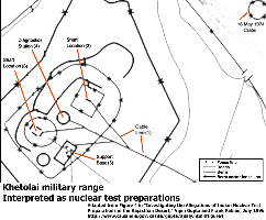
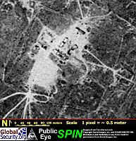
Site A
Site A and Site C are surrounded by multiple layers of perimeter barriers, and have a rectangular structures which intersects the inferred cable lines at the center of the fenced perimeter. This fits the profile of a underground nuclear test shaft location, and the configuration resembles the layout that was used for vertical shaft tests at the US Nevada Test Site.
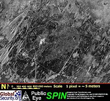
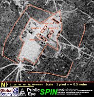
A comparison of the 1996 pre-test SPIN-2 imagery and the 2000 post-test IKONOS imagery discloses a number of changes in the appearance of this site, although the overall configuration remains largely unchanged. The outer perimeter that defines the site remains essentially unchanged. In the 1996 SPIN-2 image the site support area and the access roads are consistently clear of vegetation, whereas in the 2000 IKONOS image much of the access area appears dis-used, though the access roads remain clearly defined.
The most striking changes are evident towards the center of this site. In the 1996 image there is a roughly rectilinear assemblage of four roughly rectilinear unresolved features, anchored at the center of the site and oriented towards the northeast. Each of these four features is approximately 10 meters by 30 meters in extent, and their general location and appearance is not inconsistent with berms, sheds, or kindred features that are typical of test areas of various types. However, the nature and function of these features cannot be resolved with available imagery.
Three of these four features are entirely absent from the February 2000 IKONOS image, though the possible remnants of the fourth feature at the northern edge of the site can be discerned. This higher resolution imagery provides no further insight into the nature of these features. The central area of the site is now defined by a barely discernable circular feature, about 30 meters in radius, within which lies an area of chaotic terrain of indeterminate disposition. This circular feature is not inconsistent with a small fence, such as might be used to discourage access to a radiologically hazardous area following an underground nuclear tests, and it is vaguely suggestive of the ring of a small subsidence crater.
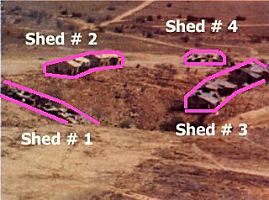
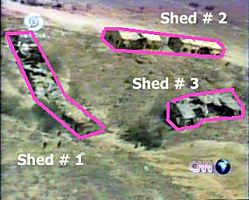
The February 2000 IKONOS imagery of Site A is not inconsistent with the use of this site for one of the May 1998 underground nuclear tests. A single aerial image of this site, released by the Bhabha Atomic Research Centre, and another aerial view broadcast by CNN, provide a broader perspective on this area which provides clear correlation with the pre-shot satellite imagery. These two photographs disclose that the small subsidence crater from the test was centered on a long shed [#1], and that a pair of parallel sheds {#2 & #3] ran at right angles to this shed. A fourth shed [#4] can be seen in the background.
| Ground Truth and Satellite Imagery |
||
| Click on the small image to view a larger version | ||
 Ground Truth Imagery of the Test Crater |
 Ground Truth Imagery of the Test Crater | |
 Khetolai Military Range |
 Khetolai Military Range - Overview | |
 Khetolai Military Range - Overview |
 Khetolai Military Range | |
|
NEWSLETTER
|
| Join the GlobalSecurity.org mailing list |
|
|
|