

Pokhran Photographic Evaluation Report
High resolution imagery is available from declassified CORONA imagery. Given the mid-1972 cut-off date for this product, it would only be useful to provide negation of the 1974 test.
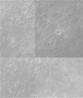
As of 24 May 2000 Russian 2-meter resolution KVR-1000 imagery coverage was not available via the SPIN-2 service on TerraServer. However, as of 03 July 2000 a pair of SPIN-2 images were available, including 01 June 1996 of the Khetolai Military Range and 20 February 1998 of the area east of the1974 Pokhran test crater. Interestingly, the standard SPIN-2 product consists of 1.5 meter resolution KVR-1000 imagery resampled to 2.0 meter resolution, although at least in the case of these two scenes a direct comparison with available IKONOS imagery indicates that this pair of SPIN-2 images is almost certainly in the native 1.5 meter resolution.
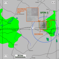
A single cloud-free archival Space Imaging IKONOS 1-meter image was available on the CARTERRAT Archive. This image was acquired on 03 February 2000, and was found on the IKONOS archive on 24 May 2000, although it was apparently not present in the archive as of 28 April 2000. In addition, a set of four images acquired in early February 2000 provide coverage of an area a few dozen kilometers to the Northwest of the May 1974 test site [bounded by latitude 27.189N and 27.396N and longitude 71.404E and 71.602E]. The IKONOS browse imagery is an interesting product in its own right, and the browse imagery of these locations apparently has a ground sample distance of about 11.25 meters.
In the absence of robust metadata, it is assumed that the full resolution IKONOS imagery has a resolution of one meter per pixel. This assumption produces results that are consistent with available maps of the area of interest, and results that are internally consistent with the assumption that the SPIN-2 imagery has a resolution of about 1.5 meters per pixel.
The SPIN-2 imagery is of rather low contrast relative to the comparable IKONOS imagery, and manual radiometric corrections were used to modify the imagery acquired from TerraServer in order to enhance interpretability and comparison with the IKONOS product. Given the differences in the source sensors, and the fact that there are substantial seasonal variation in imagery acquired roughly five months apart, no effort was made to use precision radiometric correction techniques. For ease of comparison with the higher resolution IKONOS image, the SPIN-2 image was resampled to an equivalent one pixel equals one meter screen resolution using a Bicubic Resampling algorithm. This method uses a process called interpolation, which estimating how the "new" intervening pixels should appear. In many instances, both the IKONOS and SPIN-2 images were resampled to higher screen resolutions using this method. The imagery was also resampled to lower screen resolutions using a Bilinear Resampling algorithm.
Given the absence of robust metadata for the SPIN-2 and IKONOS imagery, neither scene has been geo-referenced. Both scenes as acquired from the source are evidently north-oriented, although it is not possible to deduce the nature and extent of pre-processing that may have been done with either scene.
The provenance of this SPIN-2 and IKONOS imagery is obscure.
As is well known, the TerraServer corpus consists of US Geological Survey digital orthoquad aerial imagery of much of the United States, supplemented by Russian KVR-1000 satellite imagery of some parts of the United States, and selected areas around the world. The bulk of the global KVR-1000 coverage is centered on Western Europe, with selective coverage of very small areas in other parts of the world. Beginning in early 2000, the TerraServer archive of KVR-1000 imagery inexplicably began to include imagery that covered special weapons related locales in countries such as South Africa, North Korea, Pakistan, and India. Since these are large countries, represented by only a handful of KVR-1000 scenes on TerraServer, it is surely not by accident that these particular locations have been preferentially included in the TerraServer corpus.
As of mid-2000 the IKONOS browse archive included only slightly more extensive coverage of countries such as India, and presumably much if not all this imagery reflected customer tasking rather than random collection initiated internally by Space Imaging. Previous searches of the IKONOS archive have disclosed images of rather obscure interest. However, the image of the Khetolai military range was most evidently specifically focused on the Khetolai range, which lies at the center of the image. In this connection, it is interesting to contemplate the fact of the existence of four additional images, acquired around the same time as the Khetolai image, that together form a mosaic of an area over a dozen kilometers to the northwest of Khetolai. These five images share several common attributes, suggesting that they were all ordered by the same customer. The collection dates were all in early February 2000, but they were not present in the IKONOS brose archive until late May 2000. It is believed that imagery ordered by US government customers eventually finds its way into the publicly accessible IKONOS brose archive, though with some significant delay in order to preclude adversary assessement of current US government collection priorities.
It is evidently the case that this imagery was not collected in response to tasking from a customer in the public policy or news media communities, since some considerable time has elapsed without a public release of this imagery. Indeed, as of May 2000 an informal poll of leading experts in the non-governmental sector disclosed no awareness of the fact of the existence of this imagery.
| Satellite Imagery of the Pokhran Nuclear Test Range | |
 Imagery Coverage |
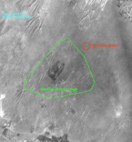
Khetolai Military Range |
 Suspect Site Northwest of Pokhran Area |
|
|
NEWSLETTER
|
| Join the GlobalSecurity.org mailing list |
|
|
|