

Pokhran [Pokharan / Pokaran]
SPIN-2 IMAGERY - 01 June 1996
The overall appearance of the Pokhran range is much as it was described by Gupta and Pabian in their 1996 analysis. The stability of the sand dunes in this area is evident in the almost complete absence of change in landscape features over the four years intervening between the 1996 SPIN-2 image and the 2000 IKONOS image. Indeed, it is possible to identify most of the individual trees and scrub brushes present in the 1996 image in the 2000 image.
The most striking difference between the 1996 SPIN-2 image and the 2000 IKONOS image is the pronounced contraction in the vegetation anomaly associated with the various security perimeters that encircle the Khetolai military range. The vegetation anomaly is created by the exclusion of grazing livestock from the secured area by the security perimeter. In the 1996 image this vegetation anomaly is triangular, with each side of the roughly equilateral triangle extends for about five kilometers. In the 2000 IKONOS image, the security perimeters that bound the range remain in evidence, but the vegetation anomaly has contracted to a lozenge some one by two kilometers in extent. It is not apparent whether this represents an opening of the security perimeters to admit grazing livestock, or whether it merely represents a seasonal variation in vegetation density. The SPIN-2 image was acquired on 01 June, around the beginning of the monsoon rains, while the IKONOS image was acquired on 03 February, nearly five months after the end of the monsoon.
| Pokhran Satellite Imagery |
||
| Click on the small image to view a larger version | ||
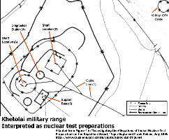 Khetolai Military Range |
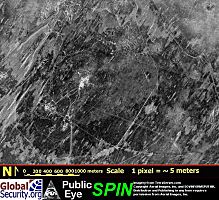 Khetolai Military Range, 1 June 1996 (Source: SPIN-2 IMAGERY) | |
|
NEWSLETTER
|
| Join the GlobalSecurity.org mailing list |
|
|
|