


CHAPTER 3. AFFECTED ENVIRONMENT
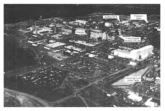
The activities described in this environmental impact statement would take place on the Savannah River Site. Most would take place in industrialized areas (Figures 2-2). The only exceptions would involve the interarea transport of nuclear materials or waste and the potential construction of a facility that would provide dry storage of spent fuel. The industrialized areas consist primarily of buildings, paved parking lots, and graveled areas. While some grassed areas occur around the administration buildings and vegetation is present along drainage ditches, most of these areas have little or no vegetation. As a consequence, these areas have minimal value as wildlife habitat. No aquatic habitat or wetlands occur in these areas, nor do threatened or endangered species. No SRS facilities have been nominated for inclusion in the National Register of Historic Places, and there are no plans for such nomination. Because the F- and H-Areas are industrial sites constructed during the 1950s, the presence of any important cultural resources remaining is unlikely.
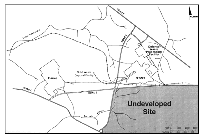
DOE has identified an undeveloped host site for the potential construction of a Dry Storage Facility. This site is to the south and east of H-Area, adjacent to SRS Road E and close to an existing railroad line (Figure 3-1). DOE could connect this site to existing electricity, water, and steam networks with minimal additional construction.
The host site is representative of many areas on the SRS that could support stabilization activities. It is almost completely forested, for the most part with 5- to 40-year-old upland pine, for which the Savannah River Forest Station (which is operated by the U.S. Forest Service) conducts an active management program. The site contains suitable habitat for white-tailed deer and feral hogs as well as other species common to the mixed pine/hardwood forest of South Carolina. DOE would conduct a detailed analysis in accordance with the provisions of the National Environmental Policy Act before implementing any decisions on the construction of new facilities on an undeveloped site.
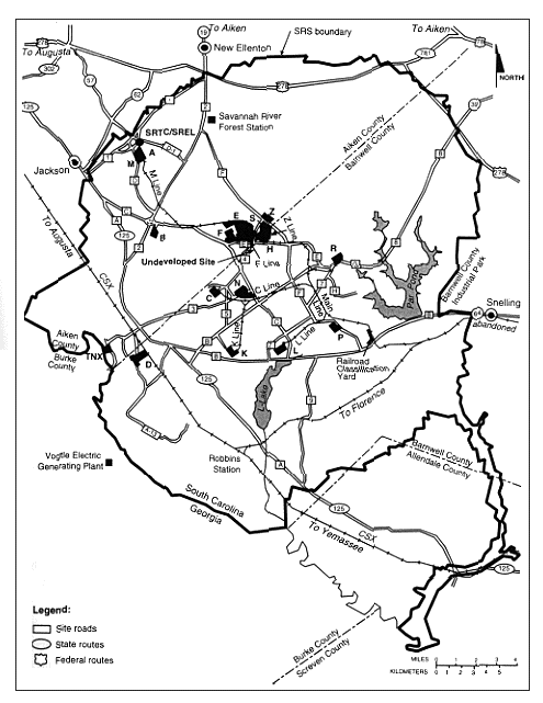
DOE would transport nuclear material or waste using existing SRS roads or railways. The primary SRS roadways (see Figure 3-2) are in good condition and are smooth and free from potholes. Railings along the roadways offer protection at appropriate locations from dropoffs or other hazards. In general, heavy traffic occurs in the early morning and late afternoon when workers commute to and from the Site. Railroads on the Site include both CSX and SRS track lines. The rails and crossties are in good condition, and the track lines are clear of vegetation and debris. The rail lines cross the surface waters, floodplains, and wetlands associated with Upper Three Runs Creek, Fourmile Branch, and Pen Branch. There is a Carolina Bay along the K-Line railway and an abandoned farm pond near the L-Line railway. A number of documents (Wike et al. 1993; Weiner and Smith 1981;
Figure 3-1.
Figure 3-2.
Bennett and McFarlane 1983; Gibbons, McCort, and Mayer 1986; Whicker 1988; Workman and McLeod 1990; and Cothran et al. 1991) provide detailed ecological information including habitat descriptions and animal species lists. Several monographs (Patrick, Cairns, and Roback 1967; Dahlberg and Scott 1971; Bennett and McFarlane 1983), the eight-volume comprehensive cooling water study (Du Pont 1987), and three EISs (DOE 1984, 1987, 1990) that evaluated operations of SRS production reactors describe the aquatic systems and biota of the SRS.
3.1 Geologic Setting and Seismicity
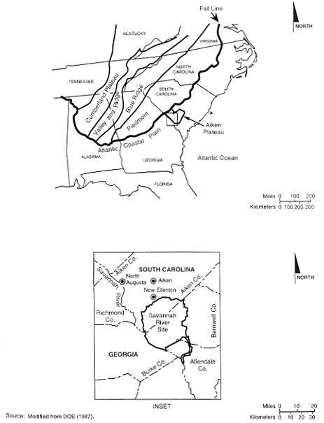
The Savannah River Site is on the Aiken Plateau of the Upper Atlantic Coastal Plain about 40 kilometers (25 miles) southeast of the Fall Line that separates the Atlantic Coastal Plain from the Piedmont (Figure 3-3). Most of the nuclear material storage areas considered in this EIS are on topographically high (upland) areas that are generally flat and lack any distinctive features. The range of local relief of these areas above nearby lowlands is from 12 meters (40 feet) in L-Area to about 60 meters (190 feet) in F-Area. Local relief above nearby lowlands reaches about 55 meters (180 feet) in M-Area, 50 meters (160 feet) in H-Area, 30 meters (90 feet) in K-Area, and 25 meters (80 feet) in P-Area. All storage areas are above the 100-year floodplain. The Final Environmental Impact Statement, Continued Operation of K-, L-, and P-Reactors, Savannah River Site, Aiken, South Carolina (DOE 1990) contains a complete description of the geologic setting and the stratigraphic sequences of the SRS. The Soil Survey of Savannah River Plant Area, Parts of Aiken, Barnwell, and Allendale Counties, South Carolina (USDA 1990) describes soil characteristics and erosion potential for the area.
3.1.1 SUBSURFACE FEATURES
Several fault systems occur off the Site northwest of the Fall Line (DOE 1990). A recent study of available geophysical evidence (Stephenson and Stieve 1992) identified six faults under the SRS: the Pen Branch, Steel Creek, Advanced Tactical Training Area (ATTA), Crackerneck, Ellenton, and Upper Three Runs Faults. Figure 3-4 shows the locations of these faults. The closest of these to areas storing nuclear materials are the Steel Creek Fault, which passes through L-Area, and the Pen Branch Fault, which passes close to K-Area. The fault lines on Figure 3-4 represent the projection of the faults to the ground surface; the actual faults do not reach the surface but stop several hundred feet below it. Based on information developed to date, none of the faults discussed in this section is "capable." A fault is capable if it has moved at or near the ground surface within the past 35,000 years or is associated with another fault that has moved in the past 35,000 years. (For a more detailed definition of a capable fault, see 10 CFR Part 100.)
Figure 3-4. Savannah River Site, showing seismic fault lines and locations of onsite earthquakes.
3.1.2 SEISMICITY
Two major earthquakes have occurred within 300 kilometers (186 miles) of the SRS. The first was the Charleston, South Carolina, earthquake of 1886, which had an estimated Richter scale magnitude of 6.8 and occurred approximately 145 kilometers (90 miles) from the Site. The SRS area experienced an estimated peak horizontal acceleration of 10 percent of gravity (0.10g) during this earthquake (URS/Blume 1982). The second major earthquake was the Union County, South Carolina, earthquake of 1913, which had an estimated Richter scale magnitude of 6.0 and occurred about 160 kilometers (99 miles) from the Site (Bollinger 1973). Because these earthquakes are not associated conclusively with a specific fault, researchers cannot determine the amount of displacement resulting from them.
In recent years, two earthquakes occurred inside the SRS boundary. On June 8, 1985, an earthquake with a local Richter scale magnitude of 2.6 and a focal depth of 0.96 kilometer (0.59 mile) occurred on the Site; its epicenter was west of C- and K-Areas. On August 5, 1988, an earthquake with a local Richter scale magnitude of 2.0 and a focal depth of 2.68 kilometers (1.66 miles) occurred on the Site; its epicenter was northeast of K-Area. Existing information does not correlate the two earthquakes conclusively with the known faults on the Site. Figure 3-4 shows the locations of the epicenters of these two earthquakes.
Outside the SRS boundary, a Richter scale magnitude 3.2 earthquake occurred on August 8, 1993, approximately 16 kilometers (10 miles) east of the City of Aiken near Couchton, South Carolina. Residents reported feeling this earthquake in Aiken, New Ellenton (immediately north of the SRS), and North Augusta [approximately 40 kilometers (25 miles) northwest of the SRS], and on the Site.
The accident analyses for this EIS evaluated a severe earthquake of a magnitude that would produce a peak ground acceleration of 0.2g, which is estimated to recur at an interval of about once every 5,000 years. The EIS analyzes earthquakes of this magnitude because this represents the SRS design-basis earthquake (i.e., new facilities would be designed to withstand an earthquake of this magnitude). The canyon structures were designed to resist a bomb blast impact against the exterior walls. The acceleration of the blast "front" from a nearby detonation would be many times the acceleration due to gravity (32 feet per second squared). For this reason, the structures would be highly damage-resistant to an earthquake with a horizontal ground acceleration of 0.20g or 20 percent of gravity at the structure base, although some materials probably would be released. Structures other than the canyons would also have some inherent resistance to seismic damage; however, these structures were assumed to fail. A precise translation of this acceleration to a Richter scale reading is not possible because the impact would be greatly affected by the type of soil in the area of the earthquake epicenter, the nearness of a shallow fault line, and attenuation of the shock wave in rock or other formations.
3.2 Water Resources
3.2.1 Surface-Water and GROUNDWATER FEATURES
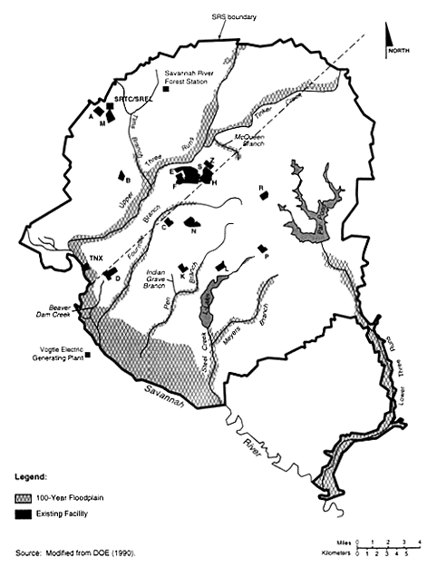
Six tributaries of the Savannah River - Upper Three Runs Creek, Fourmile Branch, Beaver Dam Creek, Pen Branch, Steel Creek, and Lower Three Runs Creek - drain almost all of the SRS (Figure 3-5). Surface waters in the vicinity of the F- and H-Areas flow into Upper Three Runs Creek and Fourmile Branch. Similarly, shallow groundwater in the vicinity recharges both Upper Three Runs Creek and Fourmile Branch.
The Savannah River, which forms the boundary between the States of Georgia and South Carolina, supplies potable water to several municipalities. Upstream from the SRS, the river supplies domestic and industrial water needs for Augusta, Georgia, and North Augusta, South Carolina. Approximately 203 river kilometers (126 river miles) downstream from the SRS, the river supplies domestic and industrial water needs for the Cherokee Hill Water Treatment Plant at Port Wentworth, Georgia, through intakes at river kilometer 47 (river mile 29), and for Beaufort and Jasper Counties in South Carolina through intakes at about river kilometer 63 (river mile 39.2).
Groundwater is a domestic, municipal, and industrial water source throughout the Upper Coastal Plain. Most municipal and industrial water supplies in Aiken County are from the deep aquifers. Domestic water supplies are primarily from the intermediate and shallow zone. In Barnwell and Allendale Counties, the intermediate zone and overlying units that thicken to the southeast supply some municipal users. At the SRS, most groundwater production is from the deep zone, with a few lower capacity wells pumping from the intermediate zone. Every major operating area at the SRS has groundwater wells; total groundwater production is from 34,000 to 45,000 cubic meters (9 to 12 million gallons) per day, similar to the volume pumped for industrial and municipal production within 16 kilometers (10 miles) of the Site (Arnett, Karapatakis, and Mamatey 1993).
Groundwater beneath the Site flows slowly toward SRS streams and swamps and into the Savannah River at rates ranging from inches to several hundred feet per year. The depth to which the onsite streams cut into the soils controls the horizontal movement of groundwater. The valleys of the smaller perennial streams allow discharge from the shallow saturated geologic formations. The valleys of major tributaries of the Savannah River (e.g., Upper Three Runs Creek) drain formations of intermediate depth, and the valley of the Savannah River drains deep formations.
Figure 3-5. Savannah River Site, showing 100-year floodplain and major stream systems.
Groundwater flow is downward at some locations on the site, including A-, M-, L-, and P-Areas. In other areas, gradient and subsequent water pressure is upward from the lower to the upper sediments. This upward flow occurs, for example, in certain sections of F- and H-Areas and around K-Area. Horizontal groundwater flow occurs at the M-Area metallurgical laboratory (to the west-northwest in the shallow aquifer and subsequent flow to the south toward Upper Three Runs Creek in the intermediate aquifer), K-Area disassembly basin (toward Pen Branch and L-Lake), P-Area disassembly basin (toward Steel Creek), F-Canyon building (toward Upper Three Runs Creek and Fourmile Branch), and H-Canyon building (toward Upper Three Runs Creek and its tributaries).
3.2.2 Surface-Water and Groundwater Quality
In 1993, the major releases of radionuclides to surface waters were 12,700 curies of tritium, 0.477 curie of strontium-89 and -90, and 0.246 curie of cesium-137. The resulting doses to a downriver consumer of river water from all radionuclides released from the Site were less than 2 percent of the EPA and DOE standards for public water supplies (40 CFR Part 141 and DOE Order 5400.5, respectively) and less than 0.2 percent of the DOE dose standard from all pathways (DOE 5400.5). From a nonradiological perspective, there was no significant difference between upriver and downriver water quality parameters. Other than 72 instances of exceeding coliform (an indicator of the presence of human or animal fecal material) standards, analyses of streams, including the Savannah River, that can receive SRS discharges met the more stringent 1992 updated river classification of Freshwaters; that is, 99.9 percent of the analyses were in compliance with the SRS National Pollutant Discharge Elimination System permit. Table 3-1 lists radioactive liquid releases by source for 1993.
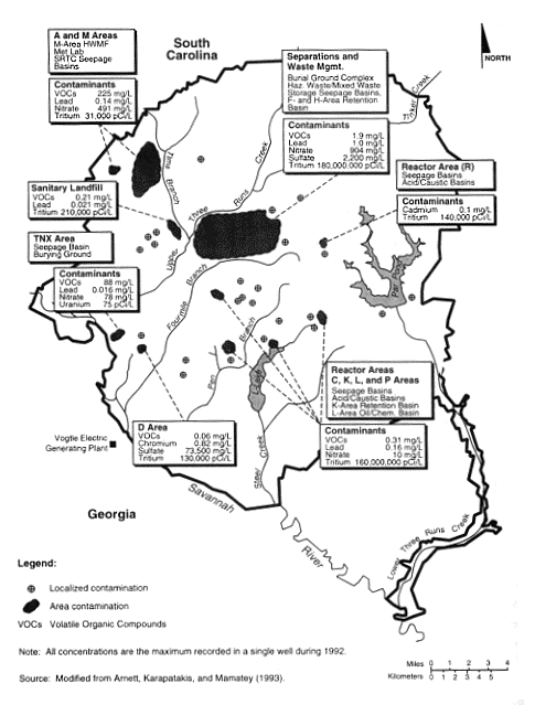
Industrial solvents, metals, tritium, and other constituents used or generated on the Site have contaminated the shallow aquifers beneath 5 to 10 percent of the SRS. These aquifers are not used for SRS operations and drinking water; however, they do discharge to Site streams and eventually the Savannah River. Figure 3-6 shows groundwater contamination on the Site (Arnett, Karapatakis, and Mamatey 1993). Most contaminated groundwater at the SRS flows beneath a few facilities; contaminants reflect the operations and chemical processes performed at those facilities. At F- and H-Areas, contaminants in the groundwater include tritium and other radionuclides, metals, nitrates, and chlorinated and volatile organics. At A- and M-Areas, contamination includes chlorinated volatile organics, radionuclides, metals, and nitrates. At the reactors (K-, L-, and P-Areas), tritium, other radionuclides, and lead are in the groundwater.
Table 3-1. 1993 liquid releases by source (including direct and seepage basin migration releases).
| Radionuclideb | Half-life (years) | Reactors | Separationsc | Reactor materials | Heavy water | SRTC/ TNX | Total |
| H-3 (oxide) | 12.3 | 2,290 | 9,880 | - | 499 | 0.129 | 12,700 |
| Sr-89,90d | 29.1 | 0.187 | 0.241 | - | 4.65×10⁻² | 2.02×10⁻³ | 0.477 |
| I-129 | 1.6×10⁷ | - | 2.20×10⁻² | - | - | - | 2.20×10⁻² |
| Cs-137 | 30.2 | 1.29×10⁻² | 0.233 | - | - | - | 0.246 |
| Pm-147 | 2.6 | - | 7.03×10⁻³ | - | - | - | 7.03×10⁻³ |
| U-235,238 | 4.5×10⁹ | - | 1.14×10⁻⁵ | - | - | - | 1.14×10⁻⁵ |
| Pu-239e | 24,000 | 5.97×10⁻⁴ | 8.65×10⁻³ | 7.64×10⁻⁵ | - | 2.66×10⁻⁴ | 9.59×10⁻³ |
a. Source: Arnett, Karapatakis, and Mamatey (1994).
b.
H = hydrogen (H-3 = tritium), Sr = strontium, I = iodine, Cs = cesium, Pm =
promethium, U = uranium, Pu = plutonium.
c. Includes F- and
H-Area releases.
d. Includes unidentified beta-gamma.
e.
Includes unidentified alpha.
Radioactive constituents (tritium, cesium-137, iodine-131, ruthenium-106, and strontium-89 and -90) above drinking water standards have occurred in F-Area monitoring wells. One well (FCA-9DR) showed activities considerably higher than others; strontium activities were especially notable, as much as 1,000 times over drinking water standards (Arnett, Karapatakis, and Mamatey 1994). Studies of flow directions, infiltration rates, and operating history indicate that this contamination is from an isolated incident that occurred more than 35 years ago (Reed 1993).
Contamination beneath the H-Canyon reflects the pervasiveness of tritium in the H-Area. The tritium is not directly from H-Canyon activities, but rather results from past use of the nearby H-Area seepage basins with subsequent transport beneath the canyon.
3.3 Air Resources
Based on SRS data collected from onsite meteorological towers for the 5-year period from 1987 to 1991, maximum wind direction frequencies are from the northeast and west-southwest and the average wind speed is 3.8 meters per second (8.5 miles per hour) (Shedrow 1993). The average annual temperature at the SRS is 17.8·C (64·F). The atmosphere in the SRS region is unstable approximately 56 percent of the time, neutral 23 percent of the time, and stable about 21 percent of the time (Shedrow 1993). In general, as the atmosphere becomes more unstable, atmospheric dispersion of airborne pollutants increases and ground-level pollutant concentrations decrease.
Figure 3-6. Groundwater contamination at the Savannah River Site.
3.3.1 Severe Weather Conditions
The SRS area experiences an average of 55 thunderstorm days per year with 50 percent of these occurring in June, July, and August (Shedrow 1993). On an annual average, lightning flashes will strike six times per year on a square-kilometer area (Hunter 1990). The highest windspeed recorded at Bush Field (Augusta, Georgia) between 1950 and 1990 was 100 kilometers (62 miles) per hour (NOAA 1990).
From 1954 to 1983, 37 reported tornadoes occurred in a 1-degree square of latitude and longitude that includes the SRS (WSRC 1993a). This frequency of occurrence is equivalent to an average of about one tornado per year. The estimated probability of a tornado striking a point on the SRS is 0.0000711 per year. This results in a "point-strike recurrence" interval of about once every 14,000 years (Bauer et al. 1989). Due to the size of the SRS, the occurrence of several individual strikes is unlikely. Since operations began at the SRS in 1953, nine tornadoes have been confirmed on or near the Site. Nothing more than light damage was reported, with the exception of a tornado in October 1989 that caused considerable damage to forest resources in an undeveloped southeastern sector of the SRS (Shedrow 1993).
From 1700 to 1992, 36 hurricanes occurred in South Carolina, resulting in an average frequency of about one hurricane every 8 years (WSRC 1993a). Because SRS is about 160 kilometers (100 miles) inland, the winds associated with hurricanes have usually diminished below hurricane force [i.e., equal to or greater than a sustained wind speed of 33.5 meters per second (75 miles per hour)] before reaching the SRS. Winds exceeding hurricane force have been observed only once at the SRS (Hurricane Gracie in 1959) (Shedrow 1993).
3.3.2 Radiological Air Quality
DOE provides detailed summaries of radiological releases to the atmosphere from SRS operations along with the resulting concentrations and doses in a series of annual environmental data reports. This section references several of these documents, which contain additional information. The information enables comparisons of current data with releases, concentrations, and doses associated with each alternative.
In the SRS region, airborne radionuclides originate from natural sources (i.e., terrestrial and cosmic), worldwide fallout, and Site operations. The SRS maintains a network of air monitoring stations on and around the Site to determine concentrations of radioactive particulates and aerosols in the air (Arnett, Karapatakis, and Mamatey 1994).
Table 3-2 lists average and maximum nontritium atmospheric radionuclide concentrations at the SRS boundary and at background monitoring locations [160-kilometer (100-mile) radius] during 1993. Tritium is the only radionuclide of SRS origin detected routinely in offsite air samples above background (control) concentrations (Cummins, Martin, and Todd 1990, 1991; Arnett et al. 1992; Arnett, Karapatakis, and Mamatey 1993). Table 3-3 lists average concentrations of tritium in the atmosphere, as measured at the boundary and offsite monitoring locations.
| Location | Gross alpha | Nonvolatile beta | Sr-89,90b | Pu-238b | Pu-239b |
|
0.0018 0.0050 |
0.019 0.063 |
<0.000088 0.00027 |
0.00000052 0.0000048 |
0.00000026 0.0000021 |
|
0.0020 0.0049 |
0.020 0.043 |
<0.00027 0.00058 |
0.00000070 0.0000059 |
<0.0000020 0.0000044 |
a. Source: Arnett (1994).
b. Monthly
composite.
| Location | 1993 | 1992 | 1991 |
| Site boundary | 30 | 27 | 21 |
| 40-kilometer radius | 9 | 11 | 11 |
| 160-kilometer radius | 4.7 | 8.3 | 8.5 |
a. Source: Arnett, Karapatakis, and Mamatey (1994).
Table 3-4 lists 1993 radionuclide releases from each major operational group of SRS facilities. All radiological impacts are within regulatory requirements.
3.3.3 Nonradiological Air Quality
The SRS is in the Augusta (Georgia) - Aiken (South Carolina) Interstate Air Quality Control Region (AQCR). This region, which is designated as a Class II area, is in compliance with National Ambient Air Quality Standards (NAAQS) for criteria pollutants. Class II is the initial designation of any area that is not considered a pristine area; pristine areas include national parks or national wilderness areas. The criteria pollutants include sulfur dioxide, nitrogen oxides (reported as nitrogen dioxide), particulate matter (less than or equal to 10 microns in diameter), carbon monoxide, ozone, and lead (40 CFR Part 50).
DOE utilized the comprehensive emissions inventory data for 1990, which is the most recent data available, to establish the baseline year for showing compliance with national and state air quality standards by calculating actual emission rates for existing sources. DOE based its calculated emission rates for the sources on process knowledge, source testing, material balance, and U.S. Environmental Protection Agency (EPA) Air Pollution Emission Factors (AP-42; EPA 1985). The inventory also included maximum potential emissions for sources permitted for construction through 1992.
DOE has performed atmospheric dispersion modeling for criteria and toxic air pollutants for actual emissions for the base year 1990 (plus potential emissions for sources permitted for construction), using the EPA Industrial Source Complex Short Term No. 2 Model. This model used data from the SRS meteorological tower for 1991 along with the 1990 emissions data to estimate maximum ground-level air pollutant concentrations at the SRS boundary. DOE added the incremental impacts associated with the alternatives evaluated in this EIS to the baseline concentrations to estimate total air quality impacts.
The South Carolina Department of Health and Environmental Control (SCDHEC) has air quality regulatory authority over the SRS and determines ambient air quality compliance based on air pollutant emissions and estimates of concentrations at the Site boundary based on atmospheric dispersion modeling. The SRS is in compliance with National Ambient Air Quality Standards for criteria pollutants and gaseous fluoride and with total suspended particulate standards, as required by SCDHEC Regulation R.61-62.5, Standard 2, "Ambient Air Quality Standards" (AAQS). Table 3-5 lists these standards and the results of the atmospheric dispersion modeling for base year 1990.
The SRS is in compliance with SCDHEC Regulation R.61-62.5, Standard 8, "Toxic Air Pollutants," which regulates the emission of 257 toxic air pollutants (WSRC 1994a). DOE has identified emission sources for 139 of the 257 regulated air toxics; the modeled results indicate that the Site is in compliance with SCDHEC air quality standards. Table 3-6 lists toxic air pollutants that are the same as those that the alternative actions described in this EIS would emit. Table 3-6 also compares maximum downwind concentrations at the Site boundary for base year 1990 to SCDHEC standards for toxic air pollutants.
Table 3-5. Estimated ambient concentrations of criteria air pollutants from SRS sources.
| Pollutantc | Averaging time | Concentration (µm3)d |
Most stringent AAQSe (national or state) (µm3) | Concentration as a percent of AAQSf (%) |
| SO2 |
Annual
24-hour 3-hour |
10 185 634 |
80g 365g,h 1,300g,h |
12.5 50.7 48.8 |
| NOx | Annual | 4 | 100g | 4.0 |
| CO |
8-hour 1-hour |
23 180 |
10,000g,h 40,000g,h |
0.2 0.5 |
| Gaseous fluorides (as HF) |
12-hour 24-hour 1-week 1-month |
0.62 0.31 0.15 0.03 |
3.7f 2.9f 1.6f 0.8f |
16.8 10.7 9.4 3.8 |
| PM10 |
Annual 24-hour |
3 56 |
50g 150g |
6.0 0.4 |
| O3 | 1-hour | NAi | 235g,h | NA |
| TSP | Annual geometric mean | 11 | 75f | 14.7 |
| Lead | Calendar quarter mean | 0.0003 | 1.5e | 0.02 |
a. Source: WSRC (1994a).
b. The
concentrations are the maximum values at the SRS boundary.
c.
SO2 = sulfur dioxide; NOx = nitrogen oxides; CO = carbon monoxide;
PM10 = particulate matter < 10mm in diameter; TSP = Total Suspended
Particulates, O3 = Ozone.
d. Based on actual emissions from all
existing SRS sources plus maximum potential emissions for sources permitted for
construction through December 1992.
e. AAQS = Ambient Air
Quality Standard.
f. Source: SCDHEC (1976).
g.
Source: 40 CFR Part 50.
h. Concentration not to be exceeded
more than once a year.
i. NA = Not available.
| Pollutantb | Concentration (µm3)c | Regulatory standard (µm3) | Concentration as a percent of standard (%) |
| Benzene | 31 | 150 | 20.70 |
| Hexane | 0.07 | 200 | 0.04 |
| Nitric acid | 6.70 | 125 | 5.40 |
| Sodium hydroxide | 0.01 | 20 | 0.05 |
| Toluene | 1.60 | 2,000 | 0.08 |
| Xylene | 3.80 | 4,350 | 0.09 |
a. Source: WSRC (1994a).
b. Pollutants listed
include air toxics of interest in relation to interim management of nuclear
materials alternatives. (Section 5.2 addresses
the effects of all air toxics.)
c. Based on actual emissions
from existing SRS sources plus maximum potential emissions for sources permitted
for construction through December 1992.
3.4 Socioeconomics
This section discusses baseline socioeconomic conditions in a region of influence where approximately 90 percent of the SRS workforce lived in 1992. The SRS region of economic influence includes Aiken, Allendale, Bamberg, and Barnwell Counties in South Carolina, and Columbia and Richmond Counties in Georgia. Socioeconomic Characteristics of Selected Counties and Communities Adjacent to the Savannah River Site (HNUS 1992) contains additional information on the economic and demographic characteristics of the six-county region.
3.4.1 Employment
Between 1980 and 1990, total employment in the six-county region increased from 139,504 to 199,161, an average annual growth rate of approximately 5 percent. The unemployment rates for 1980 and 1990 were 7.3 percent and 4.7 percent, respectively (HNUS 1992). In 1995, regional employment will be approximately 242,000. Over the 10-year planning period, employment in the region will increase at a projected average rate of 1 percent per year, reaching approximately 264,000 by 2004 (HNUS 1994).
In Fiscal Year 1992, employment at the SRS was 23,351, approximately 10 percent of regional employment, with an associated payroll of more than $1.1 billion. Due to planned budget reductions, Site employment could decline by as many as 4,200 jobs between 1995 and 1996 (Fiori 1995).
3.4.2 Population
Between 1980 and 1990, the population in the region of influence increased 13 percent, from 376,058 to 425,607. More than 88 percent of the 1990 population lived in Aiken County (28.4 percent), Columbia County (15.5 percent), or Richmond County (44.6 percent). In 1995, the population in the six-county region will be approximately 462,000. Over the 10-year planning period, the regional population will grow at a projected rate of 0.4 percent per year, reaching approximately 479,000 by 2004 (HNUS 1994). According to census data, in 1990 the estimated average number of persons per household in the six-county region was 2.72, and the median age of the population was 31.2 years (HNUS 1992).
3.4.3 Community Characteristics
Executive Order 12898, "Federal Actions to Address Environmental Justice in Minority Populations and Low-Income Populations," requires that Federal agencies identify and address, as appropriate, disproportionately high and adverse human health or environmental effects of their programs and activities on minority and low-income populations; minority populations are hereafter referred to as people of color. DOE is in the process of developing official guidance on the implementation of the Executive Order. The guidance that DOE eventually develops might depart somewhat from the approach taken in this EIS for analysis of environmental justice issues. This approach is intended to identify the potential effects from onsite activities on individuals in the identified communities of people of color or low income. The following discussion describes the framework for analysis of environmental justice issues for the alternatives considered in this EIS.
The potential offsite health impacts would result from releases to the air and to Savannah River water downstream of the SRS. For air releases, standard population dose analyses are based on an 80-kilometer (50-mile) radius because expected dose levels beyond that distance would be negligible. For liquid releases, the region of interest includes areas along the river that draw drinking water from the river (Beaufort and Jasper Counties in South Carolina and Port Wentworth in Georgia). Combining these two areas, the analysis included data (U.S. Bureau of the Census 1990a,b) for populations in all census tracts that have at least 20 percent of their area in the 80-kilometer (50-mile) radius and all tracts from Beaufort and Jasper Counties in South Carolina and Effingham and Chatham Counties in Georgia, which are downstream of the Site. DOE used data from each census tract in this combined region to identify the racial composition of communities and the number of persons characterized by the U.S. Bureau of the Census as living in poverty. The combined region contains 247 census tracts, 99 in South Carolina and 148 in Georgia.
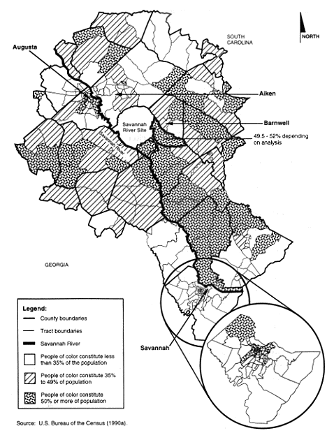
Tables 3-7 and 3-8 list racial and economic characteristics, respectively, of the population in the combined region. Table 3-7 indicates a total population of more than 993,000 in the area; of that population, approximately 618,000 (62.2 percent) are white. Within the population of people of color, approximately 94 percent are African American. The remainder of the population of people of color is made up of small percentages of Asian, Hispanic, and Native American persons. Figure 3-7 shows the distribution of people of color by census tract areas in the SRS region.
Executive Order 12898 does not define minority populations. One approach is to identify communities that contain a simple majority of people of color (greater than or equal to 50 percent of the total community population). A second approach, proposed by EPA for environmental justice purposes, defines communities of people of color as those that have higher-than-average (over the region of interest) percentages of minority persons (EPA 1994). Figure 3-7 has two shading patterns to indicate census tracts where (1) people of color constitute 50 percent or more of the total population in the census tract, or (2) people of color constitute between 35 percent and 50 percent of the total population in the tract. For this analysis, DOE has adopted the second, more expansive, approach to identify people of color communities.
Table 3-7. General racial characteristics of population in the SRS region of analysis.
| State | Total population | White | African American | Hispanic | Asian | Native American | Other | People of color | Percent people of colorb |
| South Carolina | 418,685 | 267,639 | 144,147 | 3,899 | 1,734 | 911 | 355 | 151,046 | 36.08% |
| Georgia | 574,982 | 350,233 | 208,017 | 7,245 | 7,463 | 1,546 | 478 | 224,749 | 39.09% |
| Total | 993,667 | 617,872 | 352,164 | 11,144 | 9,197 | 2,457 | 833 | 375,795 | 37.82% |
a.Source: U.S. Bureau of the Census (1990a).
b.People
of color population divided by total population.
Table 3-8. General poverty characteristics of population in the SRS region of analysis.a
| Area | Total population | Persons living in povertyb | Percent living in poverty |
| South Carolina | 418,685 | 72,345 | 17.28% |
| Georgia | 574,982 | 96,672 | 16.81% |
| Total | 993,667 | 169,017 | 17.01% |
a.Source: U.S. Bureau of the Census (1990b).
b.Families
with income less than the statistical poverty threshold, which in 1990 was 1989
income of $8,076 for a family of two.
The combined region has 80 tracts (32.4 percent) where populations of people of color constitute 50 percent or more of the total population of the tract. In an additional 50 tracts (13.5 percent), people of color constitute between 35 and 50 percent of the population. These tracts are well distributed throughout the region, although there are more of them toward the south and in the immediate vicinities of Augusta and Savannah, Georgia.
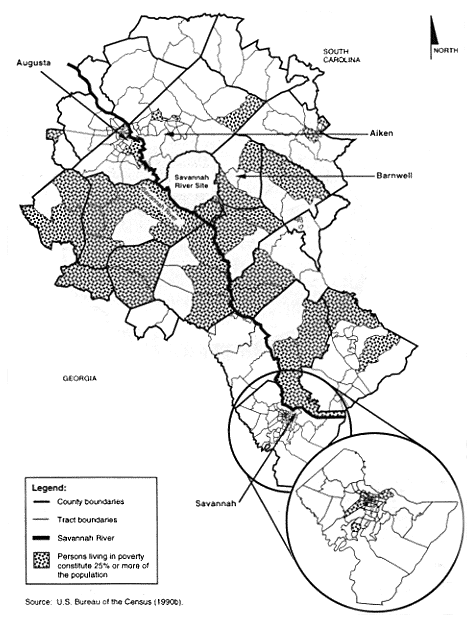
Low-income communities are defined as those in which 25 percent or more of the population is characterized as living in poverty (EPA 1993). The U.S. Bureau of the Census defines persons in poverty as those whose income is less than a "statistical poverty threshold." This threshold is a weighted average based on family size and the age of the persons in the family. The baseline threshold for the 1990 census was a 1989 income of $8,076 for a family of two.
Figure 3-7. Distribution of people of color by census tract in SRS region of analysis.
Table 3-8 indicates that in the SRS region, more than 169,000 persons (17.0 percent of the total population) are characterized as living in poverty. In Figure 3-8, shaded census tracts identify low-income communities. In the region, 72 tracts (29.1 percent) are identified as low-income communities. These tracts are distributed throughout the region of analysis, but primarily to the south and west of the SRS. As discussed in Chapter 4, no adverse health effects are likely to occur in any offsite community, including minority and low-income communities.
3.5 Public and Worker Health
3.5.1 PUBLIC RADIOLOGICAL HEALTH
The release of radioactivity to the environment from any nuclear facility is a sensitive issue for onsite workers and the public. Because there are many other sources of radiation in the human environment, evaluations of radioactive releases from nuclear facilities must consider all the ionizing radiation to which people are routinely exposed.
Public radiation exposure in the vicinity of the Site amounts to approximately 357 millirem per year, consisting of natural background radiation from cosmic, terrestrial, and internal body sources; radiation from medical diagnostic and therapeutic practices; radiation from weapons test fallout; radiation from consumer and industrial products; and radiation from nuclear facilities. Figure 3-9 shows the relative contributions of each source to people living in the vicinity of the Site. All radiation doses mentioned in this EIS are "effective dose equivalents"; internal exposures are reported as "committed effective dose equivalents."
Releases of radioactivity to the environment from the Site account for less than 0.1 percent of the total annual average environmental radiation dose to individuals within 80 kilometers (50 miles) of the Site. Natural background radiation contributes about 293 millirem per year or 82 percent of the annual dose of 357 millirem received by an average member of the population within 80 kilometers (50 miles) of the Site. Based on national averages, medical exposure accounts for an additional 14.8 percent of the annual dose, and the combined doses from weapons test fallout, consumer and industrial products, and air travel account for about 3 percent of the total dose (NCRP 1987a).
Other nuclear facilities within 80 kilometers (50 miles) of the Site include a low-level waste burial site operated by Chem-Nuclear Systems, Inc., near the eastern SRS boundary, and the Georgia Power Company's Vogtle Electric Generating Plant, directly across the Savannah River from the Site. In addition, Carolina Metals, Inc., which is northwest of Boiling Springs in Barnwell County, processes
Figure 3-8. Low income census tracts in SRS region of analysis.
Figure 3-9. Major sources of radiation exposure in the vicinity of Savannah River Site.
Depleted uranium. The South Carolina Department of Health and Environmental Control Annual Report for 1992 on Nuclear Facility Monitoring (SCDHEC 1992) documents that the Chem-Nuclear and Carolina Metals facilities do not appear to influence radioactivity levels in the air, precipitation, groundwater, soil, vegetation, or external radiation, based on State measurements. Plant Vogtle began commercial operation in 1987; in 1991, releases from the plant produced a maximally exposed individual annual dose of 0.00017 rem at the plant boundary and a total population dose within an 80-kilometer (50-mile) radius of 0.057 person-rem (NRC 1994).
In 1993, releases of radioactive material to the environment from SRS operations resulted in a maximum Site boundary individual dose from atmospheric releases of 0.11 millirem per year in the north-northwest sector around the Site, and a maximum dose from liquid releases of 0.14 millirem per year, for a maximum total annual dose at the Site boundary of 0.25 millirem. The maximum dose to downstream consumers of Savannah River water – 0.057 millirem per year – occurred to Port Wentworth public water supply users (Arnett 1994).
In 1990 the population within 80 kilometers (50 miles) of the Site was approximately 620,100. The collective effective dose equivalent to that population in 1993 was 7.6 person-rem from atmospheric releases. The 1990 population of 65,000 people using water from the Cherokee Hill Water Treatment Plant near Port Wentworth, Georgia, and the Beaufort-Jasper Water Treatment Plant near Beaufort, South Carolina, received a collective dose equivalent of 1.5 person-rem (Arnett 1994). Population statistics indicate that cancer caused 23.5 percent of the deaths in the United States in 1990 (CDC 1993). If this percentage of deaths from cancer continues, 23.5 percent of the U.S. population will contract a fatal cancer from all causes. Thus, in the population of 620,100 within 80 kilometers (50 miles) of the site, 145,700 persons will be likely to contract fatal cancers from all causes. The total population dose from the SRS of 9.1 person-rem (i.e., 7.6 person-rem from atmospheric pathways plus 1.5 person-rem from water pathways) could result in 0.0046 additional latent cancer death expected in the same population (based on 0.0005 cancer death per person-rem).
3.5.2 PUBLIC NONRADIOLOGICAL HEALTH
The hazards associated with the alternatives described in this EIS include nonradiological chemicals. Exposure to nonradiological chemicals occurs in the form of air and water pollution. Table 3-5 lists ambient air quality standards and concentrations for selected pollutants. These standards are designed to protect the public health and welfare. Because the concentrations listed in Table 3-5 are lower than the standards, DOE does not expect adverse health impacts. Section 3.2.2 discusses water quality in the vicinity of the SRS.
3.5.3 WORKER RADIOLOGICAL HEALTH
One of the major goals of the SRS Health Protection Program is to keep worker exposures to radiation and radioactive material as low as reasonably achievable (ALARA). An effective ALARA program must balance minimizing individual worker doses with minimizing the collective dose of all workers in a given group.
The purpose of an as-low-as-reasonably-achievable program is to minimize doses from both external and internal exposure. Such a program must evaluate both doses with the goal to minimize the total effective dose equivalent. ALARA evaluations must consider individual and collective doses to ensure the minimization of both. Using many workers to perform extremely small portions of a task would reduce the individual worker doses to very low levels. However, the frequent worker changes would make the work inefficient, with the result that the total dose received by all the workers would be significantly higher than if fewer workers received slightly higher individual doses.
SRS worker doses have typically been well below DOE worker exposure limits. DOE has set administrative exposure guidelines at a fraction of the exposure limits to help enforce doses that are as low as reasonably achievable. For example, the current DOE worker exposure limit is 5 rem per year, and the 1993 SRS administrative exposure guideline was 1.5 rem per year.
Table 3-9 lists the maximum and average individual doses and the SRS collective doses from 1988 to 1993.
Table 3-9. SRS annual individual and collective radiation doses.
| Year | Individual dose (rem) |
Site collective dose (person-rem) | |
| Maximum | Averageb | ||
| 1988 | 2.040 | 0.070 | 864 |
| 1989 | 1.645 | 0.056 | 754 |
| 1990 | 1.470 | 0.056 | 661 |
| 1991 | 1.025 | 0.038 | 392 |
| 1992 | 1.360 | 0.049 | 316 |
| 1993 | 0.878 | 0.051 | 263 |
a. Sources: Du Pont (1989), Petty (1993), WSRC (1991, 1992,
1993b, 1994b).
b. The average dose includes only workers who
received a measurable dose during the year.
Workers exposed to radiation have an additional risk of 0.04 percent per person-rem of contracting a fatal cancer (NCRP 1993). In 1993, 5,157 SRS workers received a measurable dose of radiation. Statistically, these workers should contract approximately 1,200 fatal cancers from all causes during their lifetimes; however, this cancer incidence rate depends on the age and sex distribution of the population. In 1993, this group received 263 person-rem and could experience as many as 0.1 additional cancer death due to their 1993 occupational radiation exposure. Continuing operation of SRS could result in as many as 0.1 additional cancer death for each year of operation, assuming future annual worker exposures continue at the 1993 level.
3.5.4 WORKER NONRADIOLOGICAL HEALTH AND SAFETY
Industrial hygiene and occupational health programs deal with all aspects of a worker's health and relationship with the work environment. The basic objective of an effective occupational health program is to protect employees against health hazards in their work environment. To evaluate these hazards, routine monitoring determines employee exposure levels to hazardous chemicals. Exposure limit values are the basis of most occupational health codes and standards. If an overexposure to a harmful agent does not exist, that agent generally does not create a health problem.
The Occupational Safety and Health Administration (OSHA) has established Permissible Exposure Limits (PELs) to regulate worker exposure to hazardous chemicals. These exposure limits refer to airborne concentrations of substances and represent conditions under which nearly all workers could receive repeated exposures day after day without adverse health effects.
Table 3-10 lists the estimated maximum annual concentrations of existing OSHA-regulated workplace pollutants modeled in and around the F- and H-Canyons. Virtually all nonradiological air pollutant emissions for each material evaluated in this EIS would be associated with these areas. These nonradiological concentrations are associated with the continued maintenance and storage of nuclear materials and, with the exception of nitric acid, carbon monoxide, sulfur dioxide, and nitrogen dioxide (as NOx), should not change from current levels. Section 4.1.2 describes the incremental impacts for nitric acid, carbon monoxide, sulfur dioxide, and NOx. Estimated concentration levels for existing OSHA-regulated workplace pollutants are less than 1 percent of the OSHA Permissible Exposure Limits, with the exception of benzene, which is 2 percent of the OSHA limit averaged over 8 hours.
DOE has established industrial hygiene and occupational health programs for the processes covered by this EIS and across the SRS to protect the health of workers from nonradiological hazards.
| Pollutant | OSHA PELb | Time period | Concentration |
| Carbon monoxide | 55 | 8-hour | 0.011 |
| Nitrogen dioxide (as NOx) | 9 | Ceiling limitc | 0.176 |
| Total particulates | 15 | 8-hour | 0.004 |
| Sulfur dioxide (as SOx) | 13 | 8-hour | 0.003 |
| Benzene |
16 3.25 |
Ceiling limitc 8-hour |
0.230 0.066 |
| Hexane | 1,800 | 8-hour | 0.066 |
| Nitric acid | 5 | 8-hour | 0.013 |
| Sodium hydroxide | 2 | 8-hour | 0.0008 |
| Toluene |
1,149 766 |
Ceiling limitc 8-hour |
0.230 0.066 |
| Xylene | 440 | 8-hour | 0.066 |
a. Estimated maximum annual impacts to workers in and around F-
and H-Canyons (WSRC 1994a).
b. Occupational Safety and Health
Administration (OSHA) Permissible Exposure Limits (PEL).
c.
Ceiling limits are permissible exposure limits that a facility cannot exceed at
any time.
REFERENCES
Arnett, M. W., 1994, Savannah River Site Environmental Data for 1993, WSRC-TR-94-077, Westinghouse Savannah River Company, Aiken, South Carolina.
Arnett, M. W., L. K. Karapatakis, and A. R. Mamatey, 1993, Savannah River Site Environmental Report for 1992, WSRC-TR-93-075, Westinghouse Savannah River Company, Environmental Protection Department, Environmental Monitoring Section, Savannah River Site, Aiken, South Carolina.
Arnett, M. W., L. K. Karapatakis, and A. R. Mamatey, 1994, Savannah River Site Environmental Report for 1993, WSRC-TR-94-075, Westinghouse Savannah River Company, Aiken, South Carolina.
Arnett, M. W., L. K. Karapatakis, A. R. Mamatey, and J. L. Todd, 1992, Savannah River Site Environmental Report for 1991, WSRC-TR-92-186, Westinghouse Savannah River Company, Savannah River Site, Aiken, South Carolina.
Bauer, L. R., D. W. Hayes, C. H. Hunter, W. L. Marter, R. A. Moyer, 1989, Reactor Operation Environmental Information Document - Meteorology, Surface Hydrology, Transport and Impacts, Volume III, WSRC-RP-89-817, Westinghouse Savannah River Company, Savannah River Site, Aiken, South Carolina.
Bennett, D. H. and R. W. McFarlane, 1983, The Fishes of the Savannah River Plant: National Environmental Research Park, SRO NERP 12, Savannah River Ecology Laboratory, Aiken, South Carolina.
Bollinger, G. A., 1973, "Seismicity of the Southeastern United States," Bulletin of the Seismological Society of America, 63, 5, pp. 1785-1808.
CDC (Centers For Disease Control and Prevention), 1993, Monthly Vital Statistics Report, Volume 41, No. 7 Supplement, January 7, 1993, "Advance Report of Final Mortality Statistics, 1990," U.S. Public Health Service, Department of Health and Human Services, Washington, D.C.
Cothran, E. G., M. H. Smith, J. O. Wolff, and J. B. Gentry, 1991, Mammals of the Savannah River Site, Savannah River Ecology Laboratory, SRO-NERP-21.
Cummins, C. L., D. K. Martin, and J. L. Todd, 1990, Savannah River Site Environmental Report for 1989, WSRC-IM-90-60, Westinghouse Savannah River Company, Savannah River Site, Aiken, South Carolina.
Cummins, C. L., D. K. Martin, and J. L. Todd, 1991, Savannah River Site Environmental Report for 1990, Volumes I-II, WSRC-IM-91-28, Westinghouse Savannah River Company, Savannah River Site, Aiken, South Carolina.
Dahlberg, M. D. and D. C. Scott, 1971, "The Freshwater Fishes of Georgia," Bulletin of the Georgia Academy of Science, 29, 1, pp.1-64.
DOE (U.S. Department of Energy), 1984, Final Environmental Impact Statement, L-Reactor Operations, Savannah River Plant, Aiken, South Carolina, DOE/EIS-0108, Savannah River Operations Office, Aiken, South Carolina.
DOE (U.S. Department of Energy), 1987, Final Environmental Impact Statement, Waste Management Activities for Groundwater Protection, Savannah River Plant, Aiken, South Carolina, DOE/EIS-0120, Savannah River Operations Office, Aiken, South Carolina.
DOE (U.S. Department of Energy), 1990, Final Environmental Impact Statement, Continued Operation of K-, L-, and P-Reactors, Savannah River Site, Aiken, South Carolina, DOE/EIS-0147, Volume I, Savannah River Operations Office, Aiken South Carolina.
Du Pont (E. I. du Pont de Nemours and Company), 1987, Comprehensive Cooling Water Study - Final Report, Volumes, I-VIII, DP-1739, Aiken, South Carolina.
Du Pont (E. I. du Pont de Nemours and Company), 1989, Radiation Exposure Report, Annual Report for 1988, DPSPU-89-11-1, Aiken, South Carolina.
EPA (U.S. Environmental Protection Agency), 1985, Compilation of Air Pollutant Emission Factors, AP-42, 4th Edition, Washington, D.C.
EPA (U.S. Environmental Protection Agency), 1993, "Office of Environmental Equity Grants Program; Solicitation Notice for Fiscal Year (FY) 1994, Environmental Justice Grants to Community Groups," 58 FR 63955, December 3.
EPA (U.S. Environmental Protection Agency), 1994, "Environmental Justice Initiatives 1993," EPA 200-R-93-001, Washington, D.C., February.
Fiori, M. P., (DOE-SR Manager), 1995, "120-Day Notification," letter to all contractor and subcontractor employees, U.S. Department of Energy, Savannah River Operations Office, Aiken, South Carolina, February 7.
Gibbons, J. W., W. D. McCort and J. J. Mayer, 1986, Semi-Aquatic Mammals and Herpetofauna of the Savannah River Plant: Comprehensive Cooling Water Study Final Report, Division of Stress and Wildlife Ecology, Savannah River Ecology Laboratory, SREL-29, Aiken, South Carolina.
HNUS (Halliburton NUS Environmental Corporation), 1992, Socioeconomic Characteristics of Selected Counties and Communities Adjacent to the Savannah River Site, Aiken, South Carolina.
HNUS (Halliburton NUS Corporation), 1994, computer listings generated from the Economic and Demographic Forecasting and Simulation Model for the SRS Region of Influence (developed by Regional Economic Models, Inc.), Aiken, South Carolina.
Hunter, C. H., 1990, A Climatological Description of the Savannah River Site, WSRC-RP-89-313, Savannah River Site, Aiken, South Carolina.
NCRP (National Council on Radiation Protection and Measurements), 1987a, Ionizing Radiation Exposure of the Population of the United States, Report No. 93, Washington, D.C.
NCRP (National Council on Radiation Protection and Measurements), 1987b, Exposure of the Population in the United States and Canada from Natural Background Radiation, Report No. 94, Washington, D.C.
NCRP (National Council on Radiation Protection and Measurements), 1993, Limitation of Exposure to Ionizing Radiation, Report No. 116, Washington, D.C.
NOAA (National Oceanic and Atmospheric Administration), 1990, Local Climatological Data Annual Summary for Augusta, Georgia, National Climatic Data Center, Asheville, North Carolina.
NRC (U.S. Nuclear Regulatory Commission), 1994, Dose Commitments Due to Radioactive Releases from Nuclear Power Plant Sites in 1991, NUREG/CR-2850, Vol. 13, Washington, D.C.
Patrick, R., J. Cairns Jr., and S. S. Roback, 1967, "An ecosystematic study of the fauna and flora of the Savannah River Plant," Proceedings of the Academy of Natural Sciences of Philadelphia, 118, 5, pp. 109-407.
Petty, K. R., 1993, Inter-Office Memorandum to Distribution, "Health Protection Department 92 Annual Report," Westinghouse Savannah River Company, Aiken, South Carolina, April 15.
Reed, J. K., 1993, Final Report of the WSRC Source Assessment Task Team: Potential Sources for Observed Contamination in Well FCA-9DR, WSRC-RP-93-045, Westinghouse Savannah River Company, Aiken, South Carolina.
SCDHEC (South Carolina Department of Health and Environmental Control), 1976, "Air Pollution Control Regulations and Standards," Regulation 61-62.5, pursuant to Section 48-1-30 through 48-1-60 of the 1976 South Carolina Code of Laws, as amended, Columbia, South Carolina.
SCDHEC (South Carolina Department of Health and Environmental Control), 1992, South Carolina Nuclear Facility Monitoring - Annual Report 1992, Columbia, South Carolina.
Shedrow, B., 1993, SRS Affected Environment, WSRC-TR-93-667, Westinghouse Savannah River Company, Savannah River Site, Aiken, South Carolina.
Stephenson, D. E., 1988, August 1988 Savannah River Plant Earthquake, DPST-88-841, E. I. du Pont de Nemours and Company, Inc., Savannah River Laboratory, Aiken, South Carolina.
Stephenson, D. E. and A. L. Stieve, 1992, Structural Model of the Basement in the Central Savannah River Area, South Carolina and Georgia, WSRC-TR-92-120, Westinghouse Savannah River Company, Aiken, South Carolina.
Turner, K., 1994, Westinghouse Savannah River Company, personal communication with E. M. Rollins, Halliburton NUS Corporation, Aiken, South Carolina, (March 1994).
URS/Blume (URS/John Blume and Associates, Engineers), 1982, Update of Seismic Criteria for the Savannah River Plant, Volume I: Geotechnical, DPE-3699, prepared for E. I. du Pont de Nemours and Company, Inc., Savannah River Plant, Aiken, South Carolina.
U.S. Bureau of the Census, 1990a, Summary Tape File 1B, Table P8, Washington, D.C.
U.S. Bureau of the Census, 1990b, Summary Tape File 1B, Table 117, Washington, D.C.
USDA (U.S. Department of Agriculture), 1990, Soil Survey of Savannah River Plant Area, Parts of Aiken, Barnwell, and Allendale Counties, South Carolina, Soil Conservation Service, Washington, D.C.
Whicker, A. D., 1988, Seasonal Dynamics of Benthic Macroinvertebrates of Pond B, Savannah River Plant, Aiken, South Carolina, National Environmental Research Park Publication, Savannah River Ecology Laboratory, SRO-NERP-16, Aiken, South Carolina.
Wiener, J. G. and M. H. Smith, 1981, Studies of the Aquatic and Terrestrial Environments of the Savannah River Plant, South Carolina: A Bibliography, National Environmental Research Park Publication, Savannah River Ecology Laboratory, SRO-NERP-7, Aiken, South Carolina.
Wike, L. D., R. W. Shipley, J. A. Bowers, C. L. Cummins, B. R. del Carmen, G. P. Friday, J. E. Irwin, H. E. Mackey, J. J. Mayer, E. A. Nelson, M. H. Paller, V. A. Rogers, W. L. Specht, and E. W. Wilde, 1993, SRS Ecology Environmental Information Document, Chapter 10, Upper Three Runs, and Chapter 21, Threatened and Endangered Fauna, WSRC-TR-93-496, Westinghouse Savannah River Company, Aiken, South Carolina.
Workman, S. W., and K. W. McLeod, 1990, Vegetation of the Savannah River Site: Major Community Types, Savannah River Site National Environmental Research Park Publication, Savannah River Ecology Laboratory, SRO-NERP-19, Aiken, South Carolina.
WSRC (Westinghouse Savannah River Company), 1991, Radiation Protection and Industrial Hygiene Annual Report 1989, ESH-QIS-910027, Aiken, South Carolina.
WSRC (Westinghouse Savannah River Company), 1992, 1990 Health Protection Annual Report, ESH-HPD-920072, Aiken, South Carolina.
WSRC (Westinghouse Savannah River Company), 1993a, Nuclear Weapons Complex Reconfiguration PEIS Data Report for the Savannah River Site, No-Action Alternative, ESH-NEP-93-0188, Savannah River Site, Aiken, South Carolina.
WSRC (Westinghouse Savannah River Company), 1993b, Radiological Control Procedure Manual 5Q, Chapter 1, Part 1, Aiken, South Carolina.
WSRC (Westinghouse Savannah River Company), 1994a, Air Dispersion Modeling for the Spent Nuclear Fuel Environmental Impact Statement - Nonradiological Emission, WSRC-RP-94-147 (Draft), C. Hunter and J. Stewart, Savannah River Site, Aiken, South Carolina.
WSRC (Westinghouse Savannah River Company), 1994b, Savannah River Site Radiological Performance, 4th Quarter 1993, ESH-PAS-94-0018, Aiken, South Carolina.
|
NEWSLETTER
|
| Join the GlobalSecurity.org mailing list |
|
|
|