

Digital Topographic Support System-Light (DTSS-L)
Combat commanders at all levels need timely and accurate terrain information and data about the battlefield if they hope to control the action upon it. There also is a need for quick turnaround, map-size, multicolor reproduction of this topographic information to support mission planning and the Commander's decision-making process. The Digital Topographic Support System-Light (DTSS-L) is designed to meet these needs.
The DTSS-L has upgraded these capabilities with newer, more capable, commercial-off-the-shelf (COTS) technology including Windows-based computer workstations, printers, scanners, and supporting peripherals. The DTSS-L uses the ERDAS Imagine image processing and ESRI's ArcInfo geographic information system (GIS) COTS software packages combined with a customized user interface and enhanced terrain analysis software.
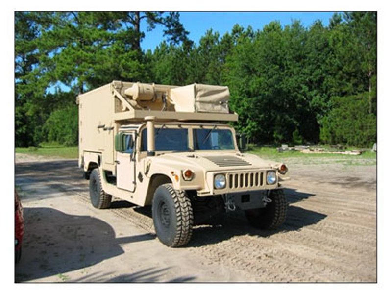
The DTSS-L is housed in an Army standard S-788 Lightweight Multipurpose Shelter (LMS) and mounted on an Army High Mobility Multipurpose Wheeled Vehicle - Extended Capacity Version (HMMWV-ECV). The DTSS-L defines the objective configuration of the DTSS, providing the Army with a degree of flexibility, transportability, and mobility not found in the legacy DTSS or the DTSS-Heavy, which were designed to a 5-ton truck as the prime mover. All Unix-based DTSS-Hs have been removed from the field and will be replaced by the Windows-based DTSS-Ls as part of a five-year cyclic upgrade that was completed in FY04-FY05.
The first 20 DTSS-L mission support equipment includes an Army Common Hardware Software 2 (CHS 2) Sun Ultra-2 workstation with a 20-inch flat panel display, a ruggedized portable Sun work-station, two Hewlett Packard 755C plotters, a 256 GB RAID storage device, and various associated peripheral devices. The remaining production systems (V2-V4) use CHS 2 Windows workstations with dual processors, HP 1000 series printer/plotters, IDEAL scanners, and two RAIDs ranging from 512 GB to 1.4 TB. Fifth production year DTSS-Ls (V5) and V1 upgrades are scheduled for FY04. V1 upgrades will have a commercial workstation while V5s will still have the CHS work-station. The same LMS shelter is being used throughout production and the V1 upgrades will receive replacement shelters. A common software suite will be used in the DTSS-L and DTSS-D, with specific versions of that package developed for the specific workstation employed.
The DTSS-L is configured for communications with other Army Battle Command Systems (ABCS) over the ABCS LAN using either fiber optic or copper wire, and includes secure and commercial voice telephone capabilities. The DTSS-L is tactically mobile and designed for world-wide transport by air, road, rail, and sea.
Capabilities
The DTSS-L is a tactical combat support system capable of receiving, formatting, creating, manipulating, merging, updating, storing, retrieving, and managing digital topographic data, then processing these data into hardcopy and softcopy topographic products. The DTSS-L accepts topographic and multispectral imagery data from the National Geospatial-Intelligence Agency (NGA) and from other sources where available.
DTSS-L functional capabilities include creation of a variety of tactical decision aids (TDAs) including: (1) Visibility/Line of Sight, (2) Mobility, and (3) Data Query/Special Product analyses. TDAs generated on the DTSS-L can be output as map products that include all applicable marginalia. These overlays are can be exported in various formats for use on systems that use viewers such as Command and Control Personal Computer (C2PC), ABCS, and Commercial Joint Mapping Toolkit (C/JMTK).
In addition to custom TDA generation, the DTSS-L provides access to the full capabilities of the image processing and GIS software packages. ERDAS Imagine image procesing software is being used to process digital imagery in order to perform imagery rectification, image map generation, thematic layer generation, limited digital database creation, and 3-D terrain perspective viewing.
The DTSS-L provides updated map background and terrain intelligence information to systems on the battlefield directly by populating and managing the Map Server. The DTSS-L also accepts terrain intelligence and data from other ABCS systems. [One of] the most recent DTSS-L to be fielded is the V4 (FY03), which houses a Map Server with a 1.4 TB RAID and an Optia Windows server to store and manage this data. By the end of FY04, all fielded DTSS-Ls contained Map Servers upon completion of the V1 upgrades.
|
NEWSLETTER
|
| Join the GlobalSecurity.org mailing list |
|
|
|