

Digital Topographic Support System-Base (DTSS-B)
The Digital Topographic Support System-Base (DTSS-B) (formerly known as the Topographic Imagery Integration Prototype (TIIP)) is the result of a US Army Europe (USAREUR) initiative to develop the capability to generate terrain information over sparsely mapped areas to support training and mission rehearsal/contingency operations. The need for this capability was highlighted by experiences in Desert Shield/Desert Storm and the former Yugoslavia.
The DTSS-B consists of multiple workstations designed to operate at Theater level in a base-production, garrison environment. The DTSS-B has increased data production capabilities over the other DTSS configurations, as well as enhanced feature and elevation data extraction tools. The DTSS-B is augmented with a direct link to commercial and National Technical Means (NTM) imagery. The DTSS-B also has increased data storage, management, and distribution/dissemination tools.
Capabilities
The DTSS-B is designed to augment National Geospatial-Intelligence Agency (NGA) capabilities at the Theater level by providing quick-response special purpose mapping, terrain analysis, and terrain-related IPB in areas of obsolete/outdated information or data. The system can produce products such as Digital Terrain Elevation Data (DTED), image map substitutes, 3-D terrain visualization, and operation/decision graphics. The DTSS-B can also update and produce Topographic Line Maps (TLMs) and create Intelligence Preparation of the Battlefield (IPB) products. Product response time varies from 10 minutes to 36 hours depending on the complexity of the product. Products range from simple image maps through contoured orthophoto maps to extensive 3-D terrain fly-throughs.
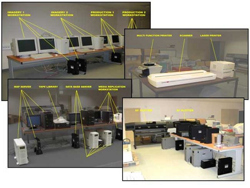
The DTSS-Base is unique in that it is the only DTSS configuration with six analogous functions or functional slices. These include: 1. Imagery Slice to ingest and process NTM imagery, extract 3D features, generate and enhance DTED, process multi-spectral images, and support IPB; 2. Production Slice to produce TDAs, value-added data, map products, and 3D visualization products; 3. Database Slice to store and manage data online with an automated archival capability; 4. Map Server Slice to provide a web accessible digital database of products and data; 5. Output Slice to output hardcopy maps and limited reproduction of digital products; 6. Media Replication Slice to replicate electronic storage media for dissemination.
|
NEWSLETTER
|
| Join the GlobalSecurity.org mailing list |
|
|
|