

Pokhran [Pokharan / Pokaran]
SPIN-2 IMAGERY - 01 June 1996
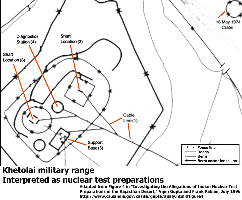
Pabian and Gupta identified at least four sites in the central Khetolai range area that could be interpreted as associated with preparations for underground nuclear tests.
- Site A and Site C - The sites are surrounded by multiple layers of perimeter barriers, and have a rectangular structures which intersects the inferred cable lines at the center of the fenced perimeter. This fits the profile of a underground nuclear test shaft location, and the configuration resembles the layout that was used for vertical shaft tests at the US Nevada Test Site.
- Site B - This site is equidistant from both of the inferred shaft locations at Site A and Site C, which makes it suitable for serving as a diagnostics station for two nuclear tests.
- Site D - This site is located near the entrance to the central area. It can be interpreted as a support base for nuclear test preparations with an unpaved road link to the inferred control point.
The overall appearance of the Pokhran range is much as it was described by Gupta and Pabian in their 1996 analysis. The stability of the sand dunes in this area is evident in the almost complete absence of change in landscape features over the four years intervening between the 1996 SPIN-2 image and the 2000 IKONOS image.
| Ground Truth Imagery |
||
| Click on the small image to view a larger version | ||
 Khetolai Military Range |
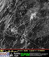 Khetolai Military Range, 1 June 1996 (Source: SPIN-2 IMAGERY) | |
|
NEWSLETTER
|
| Join the GlobalSecurity.org mailing list |
|
|
|