


4.5 GEOLOGY AND SOILS
4.5.1 Affected Environment
This section addresses the geology and soils in and around Pantex Plant. The geologic setting, including geomorphology, stratigraphy, and issues related to structural integrity, such as subsidence and seismology, is discussed. Also included are discussions of baseline soil and sediment quality on and in the vicinity of Pantex Plant.
4.5.1.1 Geology
GeomorphologyPantex Plant is located in the Southern High Plains, a region of relatively flat topography containing many surficial depressions known as playa basins. Playa basins collect surface water runoff via natural and manmade drainage systems. Considerable attention has been given to the possible origin of playas. Researchers have proposed varied ideas concerning the origin of the typical, roughly circular, shallow playa basin. One idea is that the formation of these basins is the collective result of most of the cited origins (i.e., wind, erosion by streams, lake deposits, soil formation processes, dissolution of soil carbonate, salt dissolution and subsidence, and animal activities) all acting intermittently (Pantex 1996:3.4).
Playas have been identified as a source of recharge to the Ogallala aquifer (Scanlon 1994:94). Interplaya areas, such as unlined ditches, and natural drainage areas were also identified as significant additional groundwater recharge points (DOE 1995r:3-38). Investigations of the ditches and playas, related to the potential for contamination, are being performed through the Pantex Plant environmental restoration program (Pantex 1996:5.2).
Surface elevations at Pantex Plant (excluding the playa basins) range from approximately 1,076 meters (3,530 feet) in the southeast corner of Pantex Plant to 1,096 meters (3,596 feet) in the northwest corner of Pantex Plant (USGS, 1973). Erosion by water runoff is negligible at Pantex Plant in the inter-playa areas due to the relatively flat nature of the land surface and short drainage distance (less than 5 kilometers [3 miles]) into numerous local playas (see Figure 4.6.1.11 in section 4.6.1.1). The regional slope is about 1.5 to 1.9 meters per kilometer (8 to 10 feet per mile). Slopes within the playa basins reach up to 5 percent; thus, erosion could be more active within the playa basins. Pantex Plant lies within the "Dust Bowl" region of the 1930s. Wind erosion and deposition continue to be active processes. Current agricultural practices make the land surface more susceptible to wind erosion (Pantex 1996:3.4).
StratigraphyFigure 4.5.1.11 depicts a complete stratigraphic column of the Palo Duro Basin and Amarillo Uplift in the vicinity of Pantex Plant. The stratigraphy of the sediments and rocks beneath Pantex Plant is discussed in descending chronological order from more recent layers (surface deposits) to Permian-age layers (salt deposits). Pre-Permian rocks will not be discussed because they are not relevant to the affected environment.
The uppermost formation at Pantex Plant is the Blackwater Draw Formation. The Blackwater Draw Formation consists of a sheetlike body of windblown sand and silt having a number of buried soil horizons and ranges from 12 to 22 meters (40 to 75 feet) in thickness at Pantex Plant. Surface soils of the Blackwater Draw Formation consist of Pullman soils on the plains and Randall soils in the playas (Pantex 1996:3.3).
The Pullman soils are up to 1 meter (3 feet) thick and consist of unsaturated, silty clay loam, which is slightly permeable. These soils formed in fine-textured, calcareous sediments that probably originated from windblown material. Pullman soils have little or no relief except where they surround intermittent lakes or playas.
Figure 4.5.1.1-1.--Stratiographic Column of the Palo Duro Basin and Amarillo Uplift in the Vicinity of Pantex Plant.
The Randall soils are up to 8 meters (25 feet) thick and consist of deep, very poorly drained, noncalcareous massive clay. These soils formed from sediment washed from the surface of surrounding soils within the individual playa watershed. During wet seasons, these soils may remain underwater for long periods of time (USDA 1962:14). Underlying these surface deposits (surface soils or playa basin deposits) is a 12- to 23-meter (40- to 75-foot) thick unit of unsaturated silty sand with caliche of the Blackwater Draw Formation (DOE 1994h:13).
Sediments of the Blackwater Draw Formation encountered in boreholes at the northeast corner and central south boundary of the plant show that these sediments contain numerous open tubules formerly occupied by plant roots. Buried soils within the Blackwater Draw Formation commonly contain fractures that bound soil aggregates. Both root tubules and fractures contain evidence (in the form of clay coatings, manganese stains, and calcium carbonate filaments) that these features have served as groundwater flow paths (Pantex 1996:3.3).
The Ogallala Formation underlies the Blackwater Draw Formation and is the primary water-bearing unit in the Southern High Plains. The Ogallala Formation consists of sediments derived from two distinctive depositional systems: the upper portion which consists of wind-blown deposits and the lower portion which consists of fluvial deposits. It is important to recognize that the Ogallala Formation is a sequence of related deposits rather than a single lithologic unit.
The Ogallala consists of mostly fine to coarse sand, gravel, and silt with some clay and is primarily unconsolidated. A caliche layer has formed in a 1- to 2-meter (3- to 6-foot) thick layer near the top of the formation. Ogallala thicknesses between 60 and 120 meters (200 and 4000 feet) are common in the Palo Duro Basin area with a maximum thickness of 250 meters (800 feet) occurring in the Panhandle Paleovalley northeast of Pantex Plant. There is little relief on the upper surface of the Ogallala, changes in thickness are related primarily to variations in the elevation of the pre-Ogallala surface. The pre-Ogallala surface was controlled not only by erosion but by salt dissolution as well.
The upper portion of the Ogallala Formation consists of 40 to 46 meters (130 to 150 feet) of fine-grained calcareous (calcium carbonate) wind-deposited sand. Many caliche concretions are present throughout this layer. All of these concretions are thin and discontinuous except at the top of the Ogallala Formation, where a relatively persistent caliche layer, called the Caprock caliche, is found (Pantex 1996:3.1).
The lower part of the Ogallala Formation is separated from the upper part by a relatively low permeability zone, 7 to 12 meters thick, referred to as the "fine-grained zone". Stratigraphic test wells drilled near the center and northeast corner of the site have revealed that the fine-grained zone consists of a series of coalescing and upward-fining sequences. It is important to note that the lateral extent of these sequences is unknown but varies from four sequences in the northeast corner of the plant to two sequences near the center of the plant (Pantex 1996:3.3).
Perched groundwater occurs in the discontinuous porous buried channel beneath Pantex Plant (refer to section 4.6.1.2). The position of the buried channel follows the geometry of the fine-grained zone, which was probably aligned along the regional subsurface collapse related to salt dissolution that produced topographic lows beneath and within the Ogallala sediments. Figure 4.6.1.23 in section 4.6.1 illustrates a geologic cross section of the inferred lithologies beneath and in the vicinity of Pantex Plant.
The fine-grained zone is composed of a pink, clayey fine-grained sand which is relatively impermeable to water. The irregular top of the fine-grained zone is probably due to a combination of erosion and subsidence. Within the area of Zone 12 and its vicinity, the relief of the top of the fine-grained zone is at least 18 meters (60 feet). The perched zone is bounded below by the fine-grained zone; therefore, the perched zone may not be present in areas where the fine-grained zone is topographically high or absent (DOE 1995f:3).
The lower part of the Ogallala Formation consists of fluvial (stream or river) channel deposits composed of sands and coarse gravels and associated overbank deposits composed of fine sands and clay. These fluvial deposits accumulated in the lowlands. At the same time, wind-blown deposits were accumulating in the highlands. The fluvial sediments are believed to have derived from erosion of the Southern Rocky Mountains. At Pantex Plant, drillers lithology logs for wells penetrating the Ogallala show much lateral variation in the Ogallala deposits; wells only one-half mile apart often are not particularly easy to correlate in detail. Typically, correlations are limited to the upper interval, the fine-grained zone, and the lower interval. The nature of the depositional environments proposed for the Ogallala is such that only the sheets of windblown sediments should exhibit much lateral extent. It is important to note that the complex heterogeneity of the Ogallala Formation plays an important role in groundwater movement (Pantex 1996:3.3). Hydrologic aspects of the Ogallala Formation are discussed in section 4.6.1.2.
The Dockum Group underlies the Ogallala Formation and consists of siltstones, sandstones, conglomerates, and claystone. Less than 30 meters (100 feet) of Dockum Group strata are present below Pantex Plant. Toward the northeast portion of Pantex Plant, the Triassic Dockum strata have been eroded, and the underlying Permian strata are in contact with the Tertiary-age Ogallala Formation (Figure 4.5.1.11) (Pantex 1996:3.3).
Underlying the Dockum Group are the Upper and Middle Permian layers, which are composed predominantly of thick and widespread deposits of salt. The Lower Permian consists predominantly of complex accumulations of shale, limestone and argillaceous limestone, and dolomite. The total thickness of salt deposits under Pantex Plant have been estimated to exceed 300 meters (1,000 feet) (Pantex 1996:3.3).
4.5.1.2 Structural Integrity
The structural integrity or stability of the geological formations underlying Pantex Plant is important to the geotechnical stability of buildings and other operational features (e.g., utility structures) onsite. Two main geological processes are relevant to the Pantex Plant vicinity: seismic activity and subsidence. Slope stability is not an issue at Pantex Plant due to the relatively flat surface topography.
Regional GeologyThe underlying geology is made up of two major basins in the Texas Panhandle; these are the Anadarko and the Palo Duro basins. These basins are separated by a west-northwest trending uplifted area comprised of the Amarillo Uplift and the Oldham-Harmon Trend. The Anadarko Basin is asymmetrical with the deepest portions and steepest flank occurring adjacent to the Amarillo Uplift (Pantex 1996:3.2). The Amarillo Uplift is part of the Pennsylvanian-age Ancestral Rocky Mountain building belt that extends from Utah to Oklahoma.
The Whittenburg Trough separates the Amarillo Uplift from the Bush and Bravo Domes which are the result of strike slip faulting associated with the formation of the Oldham-Harmon Trend. This narrow deep trough is approximately 15 kilometers (10 miles) wide and 55 kilometers (35 miles) long and extends from the northwestern Tascosa Basin to the southeastern Carson Basin (TBEG 1989a:19, 39). The Pantex Plant is located at the southeastern edge of the Whittenburg Trough in the Carson Basin (see Figure 4.5.1.21). The faults that could potentially contribute to the risks associated with earthquakes at the Pantex Plant are related to the structures described above.
Figure 4.5.1.2-1.--Pennsylvanian and Lower Permian Tectonic Structures.
Seismicity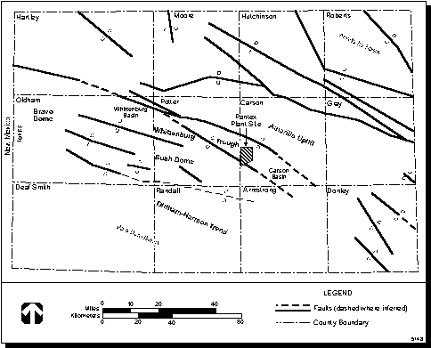
Less than 100 years of seismic data are available for the region around Pantex Plant, only a few decades of which is recorded instrumentally. In addition, accurate and sensitive seismic coverage for Pantex Plant is not available; the regional seismicity record is not complete for all events that have occurred in the Texas Panhandle (Pantex 1996:3.5).
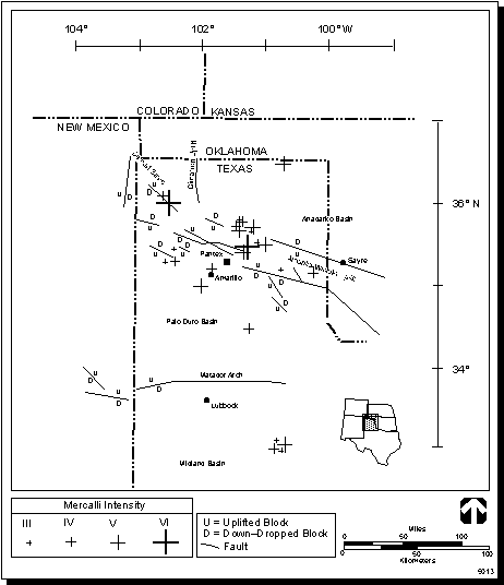
An assessment of natural hazards at Pantex Plant, which included a study of seismic events, concluded that intense seismic events could pose a threat to the structural integrity of buildings, including their foundations (Jacobs 1993:5-3). Approximately 25 earthquakes have been recorded in the Texas Panhandle, the largest with a maximum intensity of VI on the Modified Mercalli Scale, a scale based on observed damage that is used in the absence of instrument recording (Table 4.5.1.21). An earthquake of this intensity in the Texas Panhandle would not result in structural damage except for a few instances of fallen plaster or damaged chimneys (Pantex 1996:3.5). Figure 4.5.1.22 shows the locations and intensities of earthquakes in the Texas Panhandle and their relation to tectonic features.
In the Panhandle region, earthquakes with magnitudes of greater than or equal to 5.0 on the Richter scale are predicted to occur with a frequency on the order of four times in 100 years. The annual probability of a maximum credible earthquake (6.3 on the Richter scale) occurring within a distance of 16 kilometers (10 miles) of Pantex Plant, however, is very lowon the order of 10-3 to 10-4 (Pantex 1996:3.5).
Three major subsurface faults and one minor surficial fault exist in the area of the Pantex Plant, and these are located as follows: (1) approximately 250 kilometers (155 miles) long, about 40 kilometers (25 miles) north of the site, (2) approximately 69 kilometers (43 miles) long, about 8 kilometers (5 miles) south of the site, (3) approximately 64 kilometers (40 miles) long, about 11 kilometers (7 miles) north of the site, and (4) approximately 6 kilometers (4 miles) long, about 32 kilometers (20 miles) northwest of the site (surficial). However, there is no evidence of active faults at the Pantex Plant (DOE 1995i:11).
The procedure used for evaluating the risk from earthquakes to the Pantex Plant assumes that the largest earthquake to be expected in the region can happen anywhere in the region, which also includes at Pantex itself (DOE 1994aa). Within the southern plains seismic zone, the estimated recurrence interval for a 6.5 Richter magnitude earthquake is once in a thousand years (Blume 1976:41). Section 4.14, Human Health, presents the accident scenarios that could result in a release of radioactive or other hazardous material as a result of an earthquake at the Pantex Plant.
SubsidenceThe presence of salt beds in Permian formations and the ongoing dissolution of some of those beds are addressed because of the potential for salt dissolution. Salt dissolution can cause subsidence, which may result in collapse depressions, sinkholes, fractures, or faults. Table 4.5.1.22 summarizes the Permian formations and estimated thicknesses of salt deposits beneath Pantex Plant.
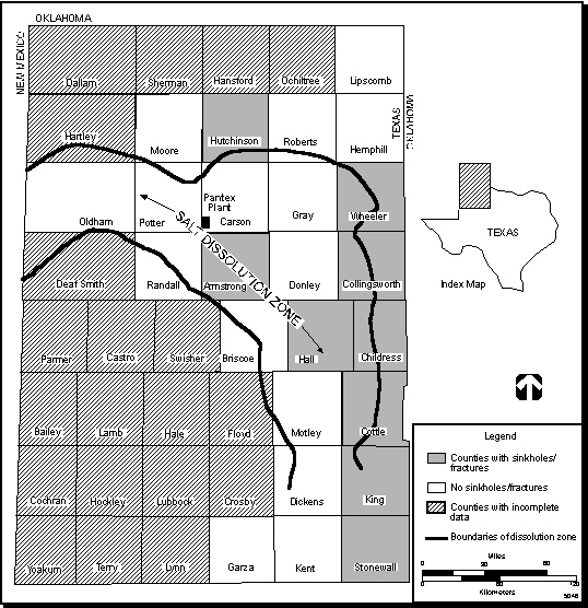
The presence of saline springs around the margins of the Southern High Plains indicates active dissolution. Recent work using shallow seismic data has determined that the structures beneath the playas on Pantex Plant and adjacent areas show displacement of Ogallala strata. This displacement is attributed to the dissolution of underlying salt beds (TBEG 1994a:27, 29).
While salt dissolution is an active process in the region, it is a very slow process relative to human activities (Gustavson 1980). Most active salt dissolution in the region is concentrated near the Eastern Caprock and at the Canadian River Escarpments (Pantex 1996:3.7). Figure 4.5.1.23 shows zones of active salt dissolution and counties in which associated sinkholes and fractures have been identified. Sinkholes and fractures have not been identified in Carson County, where Pantex Plant is located. However, sinkholes and fractures have been identified in adjacent Armstrong County to the south and Hutchinson County to the north (Gustavson 1981:10).
Table 4.5.1.2-1.--Modified Mercalli Intensity Scale of 1931 Abridged Version (.pdf)
Figure 4.5.1.2-2.--Earthquakes in the Texas Panhandle and Their Relation to Tectonic Features.
Table 4.5.1.2-2.--Salt Present Beneath Pantex Plant in the Permian Formation (.pdf)
4.5.1.3 Soil and Sediment Quality
Soil TypesThe soil types at and in the vicinity of Pantex Plant, including the land leased from Texas Tech University (TTU)Texas Tech University, belong to the Pullman-Randall soil association. The Pullman-Randall soil association consists of nearly level to gently sloping deep noncalcareous loamy soils. The Pullman soils occupy the interplaya areas at Pantex Plant and make up about four-fifths of the Pullman-Randall soil association. These soils consist of silty clay loam and are deep and well drained. The slopes range from 0 to 1 percent in the interplaya areas and 1 to 3 percent near the playas. Pullman soil has a high natural fertility, is slightly permeable, and has the ability to retain a moderate amount of water (Pantex 1996:7.1). This soil is classified as a Mollisol, which is noted by wide, deep cracks throughout the year (USDA 1981:ii). These cracks aid in groundwater recharge. The major land uses are grazing and dryland farming (Foth 1984:268).
The Randall clay soils are generally found in the bottom of the playas. They are somewhat poorly drained but have high natural fertility, very slight permeability, and high available water capacity except during droughts (Pantex 1996:7.1). This soil is classified as a Vertisol, which contains a large amount of clay and has cracks at some times of the year (USDA 1981:ii). Agriculturally, these soils have great potential (Foth 1984:280, 282).
Within the Pantex Plant region of influence (ROI), land use is predominantly agricultural. In the High Plans areas of both Carson and Potter counties, Pullman soils are the most extensive arable soils in Texas (Pantex 1996:7.1, 10.1). According to the 1992 Census of Agriculture, farming and ranching contributed nearly $300 million to the economy of the ROI. Extensive description of cropland, rangeland, and associated soils are provided in the Pantex Plant Environmental Information Document (Pantex 1996).
General Environmental Restoration ProcessAn environmental restoration (ER)environmental restoration (ER) or cleanup process is typically governed by the Resource Conservation and Recovery Act (RCRA) or the Comprehensive Environmental Response, Compensation, and Liability Act (CERCLA) (in some cases, both) and their associated regulations. Both sets of regulations govern how environmental contamination is defined, characterized, and remediated. While there are regulatory differences, they generally follow a common process. This common process includes the following steps: initial assessment of suspected areas of contamination; a preliminary prioritizing of areas that should be characterized; planning and implementing a formal sampling and analysis program; drafting of recommendations based on the data as to how much remediation, if any, is needed for each area; review and approval of these recommendations by the regulator; feasibility studies for alternative methods of remediation; and implementation of remedial actions and post-remediation activities. The following is a description of the common process by which environmental contamination is characterized and remediated.
Initially, an assessment of a site or facility is performed. This assessment can be conducted by the facilitys personnel or by personnel from the Environmental Protection Agency (EPA) and the States regulatory agency. This assessment identifies places where hazardous materials (as defined by the appropriate regulations) are being, or could have been, released to the environment. This identification process starts with the review of the existing documentation, discussions with facility personnel, and onsite observations. Areas suspected of being contaminated are called solid waste management unit (SWMU)solid waste management units (SWMUs) under RCRA and Operable Units (OUs) under CERCLA. These SWMUs or OUs can be single areas of suspected contamination or a grouping of such places.
After the identification of the SWMUs or OUs, priorities are set by the regulators concerning the timing of investigations and any immediate remediations that might be needed. A detailed and formal priority setting process can involve an investigation of the degree of threat to human health and the environment potentially posed by the suspected contamination. This investigation can include more detailed review of documentation, further discussions with current and past employees, and even some sampling of the SWMUs or OUs. The degree of threat posed by the SWMUs or OUs is determined by considering a conservative estimate of the level of contaminants suspected to be present and the potential pathways for exposure to the human environment. The SWMUs or OUs are then ranked according to the degree of perceived threat. Those SWMUs or OUs with a high ranking are usually designated for immediate remediation. The remainder can be slated for full investigation and sampling according to their perceived threat.
The investigative process involves the preparation and subsequent approval of work plans by the regulators and stakeholders. Sampling and analysis of the areas are then performed. At this point, the types and amounts of contamination present at the facility are fairly well characterized. This allows for reasonable projections as to the amount of cleanup activity that might ultimately be needed to accomplish the ER program goals. Based on the analysis of data, recommendations are made as to whether individual SWMUs or OUs need either immediate remediation, feasibility studies of different remediation methods, additional sampling and characterization, or no further action (NFA). These recommendations are based on evaluations of the types and amounts of contamination indicated by the sampling data and the associated health risk levels set by the regulators. A draft report is sent to the regulator reporting the data and analyses as well as the cleanup recommendations. After review by the regulator, subsequent revision of the report, and final approval by the regulator, the final report is made available to the public. The approval of the report includes approval of the recommendations.
After the approved report is issued, any additional work is performed on those SWMUs or OUs needing further sampling and characterization. Those SWMUs or OUs that do not need additional characterization or cleanup are then taken out of the ER investigation program. Monitoring and maintenance activities may continue at these sites. In accordance with the recommendations approved in the final report, cleanup of the SWMUs or OUs needing immediate remediation is initiated, and feasibility studies to evaluate alternative methods for cleaning up or immobilizing the contamination in the remaining SWMUs or OUs are started. These feasibility studies are submitted to the regulator for review and determination of the appropriate cleanup method. Subsequent to the regulators determination, cleanup work begins on the remaining SWMUs or OUs.
Once it is demonstrated that a SWMU or an OU has been remediated to the satisfaction of the regulator, it is closed. A closed SWMU or OU can still have some continuing activities, such as ongoing remediation of groundwater. Some remedial actions can be initiated in advance of the formal process, but these remediations are still reviewed by the regulators. If an advance remedial action is not satisfactory to the regulators, further remediation of the SWMU or OU will be required.
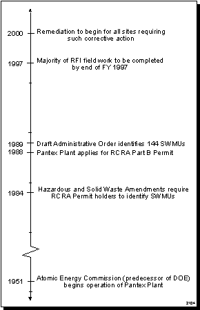
Environmental Restoration Process at Pantex PlantPantex Plants ER program is currently being conducted under RCRA in accordance with the Hazardous Waste Permit and EPA and State of Texas regulations. A timeline showing key dates for the Pantex Plant ER program is shown in Figure 4.5.1.31. The approval for RCRA methodologies is contained in the hazardous waste permit. All decisions and determinations associated with the ER program are made in negotiation with the regulators. Since CERCLA also applies to Pantex Plant, EPA placed the plant on the National Priorities List on May 31, 1994. Negotiations are currently underway with EPA and the State of Texas to integrate the two processes. The current plan is to complete the remediation process in such a way as to satisfy both RCRA and CERCLA requirements. In addition, Pantex Plant currently plans to perform advance remedial actions (i.e., interim and voluntary corrective actions) where feasible.
Under the RCRA regulations, 144 SWMUs (i.e., places of suspected contamination) have been identified at Pantex Plant. The 144 SWMUs were combined into 14 groups for investigation and are discussed in the Soil and Sediment Quality at Solid Waste Management Units subsection which follows. All prioritization of work activities associated with ER at Pantex Plant has been closely coordinated with EPA and TNRCC. The methodology for Pantex Plant prioritization has been to concentrate on areas of contamination which pose the greatest risk to the public health and other biological populations, and to clean up areas of contamination which are easily corrected. This methodology allows Pantex Plant to focus resources on priority sites while accelerating cleanup and reducing human health and ecological risks. Both EPA and TNRCC have approved this methodology through the issuance of the RCRA permit.
Of the 14 RCRA Facility Investigations (RFIs) ongoing at the plant, 12 have proceeded to the draft report stage. The rest of the RFIs have proceeded only as far as the sampling and analysis stage. At this point, the types and amount of contamination present at Pantex Plant is fairly well characterized, allowing projections to be made as to the amount of cleanup activity that might ultimately be needed to accomplish the ER program goals. Based on the levels of contamination that have been reported in the 12 draft RFIs and the range of contaminant levels that are being seen in the other investigations, many of the 144 SWMUs are expected to be recommended for no further sampling or remediation (i.e., No Further Action (NFA)). While those recommendations are only in draft form and are subject to review and approval by the State of Texas, they indicate that the types and amounts of contamination at the plant are much less than initially estimated. Plans by the plant to initiate advance remedial actions are reflected in the current reduced estimates of impacts and waste projections that would result from the ER program.
Soil and Sediment Quality at Solid Waste Management UnitsPast industrial operations at Pantex Plant have generated both solid and liquid wastes, including high explosive(s) (high explosive(s) (HE)HE) materials, organic solvents, and metals.
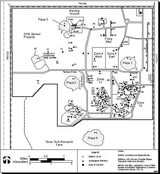
In January 1989, EPA conducted a RCRA facility assessment to identify SWMUs, (defined as any unit from which hazardous constituents may migrate) that may require investigation and/or corrective action under the 1984 Hazardous and Solid Waste Amendments to RCRA. In September 1989, the draft Administrative Order of Consent, pursuant to Section 3008(h) of RCRA, was issued. The ER group identified 144 SWMUsolid waste management unit (SWMU)s, of which 113 SWMUs were organized into 14 groupings (see Figure 4.5.1.32, Figure 4.5.1.33, and Table 4.5.1.31).
A site may be initially designated as a SWMU during the RCRA facility assessment based on process knowledge, visual observations, or even the recollection of a single employee regarding past accidents, spills, or operations, before confirming the presence of contaminants by collecting and analyzing samples from the site. NFA may be recommended for many of the SWMUs after sampling and analysis of the site confirms either low levels or probable absence of contamination due to natural degradation of the contaminants over time. In addition, NFA may also be recommended if contaminant levels are below appropriate Texas Natural Resource Conservation Commission (TNRCC)TNRCC Risk Reduction Standards (RRS), which are discussed in detail later in this section.
RFIs are conducted by the ER group at Pantex Plant to determine whether hazardous constituents have been released into the environment from the SWMUs or areas of concern. The 14 groupings are undergoing investigations on independent schedules. Thirty-one of the sites are either active non-RCRA sites or sites that could not be verified and located in subsequent field surveys. The 31 sites are being reviewed to verify that no hazardous materials are present; then they will undergo administrative closure.
TNRCC has established three closure/remediation performance standards (RRSs 1, 2, and 3) that are applicable to remedial actions undertaken in response to a release or spill. These risk reduction rules attempt to clarify cleanup levels across the state while reducing time delays and accelerating both the investigation and remediation of contaminated sites. The ER environmental restoration (ER)group at Pantex Plant has compared analytical results from soil and sediment samples to Texas Natural Resource Conservation Commission (TNRCC)TNRCC RRSs 1, 2, or 3.
RRS 1 requires removal and/or decontamination of all waste, waste residues, leachate, and contaminated media to background levels unaffected by waste management or industrial activities. 30 TAC 335.554 (d) states that "If the Practical Quantification Limit (PQL) is greater than background, then the PQL rather than the background shall be used as the cleanup level provided that the person satisfactorily demonstrates to the executive director that lower levels of quantification of a contaminant are not possible." The PQLs are generally defined as the lowest level (concentration) quantifiable among laboratories within specific limits during routine laboratory operations.
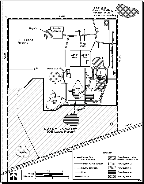
Figure 4.5.1.3-3.--Pantex Ditches and Playas Flow System.
RRS 2 requires removal and/or decontamination of all waste, waste residues, leachate, and contaminated media to standards and criteria such that any substantial present or future threat to the human health or environment is eliminated.
RRS 3 requires that removal, decontamination, and/or control of all waste, waste residues, leachate, and contaminated media occur to levels and in a manner such that any substantial present or future threat to human health or the environment is eliminated or reduced to maximum extent practicable. Because of greater concentrations of contaminants that may be left at the site with RRS 3, an evaluation of the effectiveness of the proposed remedy must be submitted to TNRCC and approved before implementation of the remedy.
RRSs 1 and 2 are the goals for determining cleanup levels and as decision criteria for additional sampling needs at a site. The "cleanup" levels represent the concentrations below which any additional site characterization or remedial action initiatives would be for the purpose of satisfying objectives other than minimizing human health risks. For example, observations of a specific chemical hazard in excess of background (RRS 1) but within acceptable risk-based criteria (RRS 2) may be acted upon differently by DOE under differing site-specific conditions. The cleanup for contamination located at 1.5 to 3.0 meters (5 to 10 feet) below ground surface is to background (RRS 1), thus avoiding deed recording requirements with RRS 2 (30 TAC 335.560) and future liability relative to a potential changing land use classification. Conversely, for the same contaminant at the same concentration located at a depth of 1.5 to 30 meters (5 to 100 feet) below ground level, DOE is likely to accept the criteria outlined in RRS 2 in which technical feasibility and cost limitations preclude cleanup to background.
By virtue of 30 TAC 335.557 (3), the future land use designated at Pantex Plant is nonresidential. However, in areas subject to excessation, the land use may revert to residential, thereby requiring increased scrutiny of the site to determine if risk-based criteria for a residential scenario have been satisfied. The DOE risk managers will need sufficient characterization data regarding these sites to quickly determine the most prudent closure strategy to assume; i.e., cleanup to background or to some risk-based level established for residential or nonresidential uses. The decision criteria is generally determined by processes such as the one described above.
The RRSs are continually being revised as new information becomes available. Preliminary Remediation Goals (PRGs) are, therefore, currently accepted cleanup levels and may be revised as RRSs are revised. Further explanation on the methodology for applying the RRSs to RFIs being conducted at Pantex Plant can be found in the Draft Final Risk Reduction Rule Guidance for Pantex Plant RCRA Facility Investigations (DOE 1994z).
All RFI work plans have been approved, and field investigations have been initiated at all sites. RFI reports have been completed for five ALPX groupings: ALPX01, ALPX02, ALPX06, ALPX08, and ALPX12 (see Tables 4.5.1.31 and I.1.11). These documents are in draft form and are currently being reviewed by TNRCC. Adequate data have been collected on many of the SWMUs to recommend either NFA or interim corrective measures (ICMs). ER of the SWMUs at Pantex Plant is ongoing concurrently with the generation of this document. The information presented below is the latest published data available. Five of the draft RFIs are at a stage where the data may be referenced in this EIS and are discussed further below. Additional data will be provided in the Final EIS as new information becomes available.
The Burning GroundBurning Ground (ALPX01) grouping, located adjacent to the eastern side of Playa 3, consists of the former chemical burn/solvent evaporation pit, explosive burn pads, landfills, burn trays, burn racks and flashing pits, burn cages, and demonstration facilities (USCOE 1995:iii, v). The site is used for the burning ofhigh explosive(s) (HE) HE components and treatment of HE-contaminated waste and various HE-contaminated liquids and solvents.
Disposal of residues from burning of solvents at the site was discontinued in the early 1980s (Pantex 1994a:2-1). The highest concentrations of contaminants were found in the landfills; however, contaminants have not migrated past the landfills boundaries (Pantex 1996:15.4). Primary contaminants are HE, solvents, and metals. Phase II of the RFI was completed in November 1995, and a revised Draft Final RFI report has been submitted to TNRCC. Although contamination is generally limited to the upper 6 meters (20 feet) of soil, some volatile organic compounds (VOCs) have been detected at deeper intervals (Pantex 1996:15.4). Hotspot removal ICMs may be required at selected sites. DOE may also recommend to TNRCC some in situ remediation such as soil vapor extraction and bioremediation based on final data review (PC 1996b:3).
The Draft RFI Report for the Burning Ground Assessment was completed in May 1995 and submitted to TNRCC in August 1995. The following is a summary of the contaminants of potential concern identified in the soil during this investigation that exceeded the decision criteria. The contaminants include HE, metals, pesticides, and semivolatile organic compound (SVOC)semivolatile organic compounds (SVOCs). HE compounds that exceed the decision criteria for soil include RDX, 1,3,5-TNB, and 2,4,6-TNT, HMX (surface soil only) and 1,3-DNB (subsurface soil only). Also, a contaminant of potential concern, 4-amino 2,6-dinitrotoluene, has been identified in the soils. RDX had a range of concentrations exceeding the decision criteria (2.6 milligrams/kilogram for surface and subsurface soil) in surface soils of 2.9 to 510 milligrams/kilogram and 2.6 to 64 milligrams/kilogram in subsurface soil.
Seven metal compounds were detected in soil samples at concentrations which exceed the decision criteria. Nickel and vanadium concentrations only exceeded the surface soil decision criteria (0 to 2 feet [0 to 0.6 meters] in depth). Arsenic only exceeded the decision criteria in one subsurface soil sample. Barium, copper, lead and mercury were detected in surface and subsurface soil samples above decision criteria. Barium had a range of concentrations exceeding the decision criteria for surface soils (200 milligrams/kilogram) of 200 to 2,440 milligrams/kilogram. Lead exceeded the decision criteria for surface soils (15.7 milligrams/kilogram) ranging from 16 to 160 milligrams/kilogram. Mercury exceeded the decision criteria for surface soils (0.20 milligram/kilogram) ranging from 0.22 to 1.7 milligrams/kilogram.
Four pesticides (aldrin, alpha-BHC, dieldrin, and gamma-BHC) were identified in the soil that exceed the decision criteria. SVOCs exceeding the decision criteria for soil include benzyl alcohol and bis-(2-ethylhexyl) phthalate (USCOE 1995). Sampling of soil at the Burning Ground is also conducted on an annual basis. These sampling results are discussed in the soil and sediment sampling subsections that follow.
The High Priority Potential Release Sites group (ALPX02) consists of five olid waste management unit (SWMU)SWMUs, one area of concern (AOC), and three firing sites. Phase I and II fieldwork has been completed. The nine sites were split into two separate RFI reports. The two Draft Final RFI reports were submitted to the TNRCC for review in September 1994 and March 1995, respectively (Pantex 1996:15.4).
Chemical constituents detected in the soil and sediment at SWMUs north of Pantex Drive include minor amounts of high explosive(s) (HE)HEs, metals, volatile organic compound (VOC)VOCs and semivolatile organic compound (SVOC)SVOCs. Elevated levels of lead were detected east of Playa 3 and north of Zone 4 at Firing Site 22. Low concentrations of metals and common anions were detected in soils of the inactive, lined, solar evaporation pond located in Zone 11. Elevated levels of lead and chromium were detected in soils on the northeast side of Building 1268 (an electroplating facility on the east side of Zone 12). Low concentrations of metals were detected in soils near Building 1259s subsurface leaching system. Lead, VOCs and SVOCs were detected in soils at the former solvent disposal pit located in the northeastern corner of Zone 12.
In 1995, ICMs were conducted on the Building FS16 surface impoundment and sump, FS22 container, and Building 1268 concrete sump. Contaminants included chromium and HE. Confirmation sampling indicated cleanup action attained RRS 2 levels, and Pantex Plant has recommended this grouping to TNRCC for NFA. No additional cleanup is anticipated for this SWMU grouping (Pantex 1994a:3-1 through 3-4, PC 1996b:2).
The Former Cooling Tower (ALPX03) was used for the HE machining operations water cooling from 1950 to 1964. The unit was dismantled in the early 1970s, and now only a concrete slab remains. Results from the Phase I analysis revealed low levels of metals, volatile organic compound (VOC)VOCs, semivolatile organic compound (SVOC)SVOCs, nitrogen series (as nitrate and nitrite), and high explosive(s) (HE)HE in the near-surface and subsurface soils. Barium, lead, and hexavalent chromium were detected in concentrations exceeding background but were below RRS 1 levels. The RFI report prepared and submitted to Texas Natural Resource Conservation Commission (TNRCC)TNRCC on October 15, 1993 recommended NFA. Subsequent to this investigation, ancillary piping, which may have led to the cooling tower, was discovered. Thus, additional characterization work has been initiated to characterize and evaluate the need for further action (Pantex 1996:15.4; Pantex 1994a:4-1, 4-2; PC 1996b:2). Treatability Study fieldwork started in May of 1996. Soils will be analyzed for total and hexavalent chromium. Treatability/remediation activities will continue into 1997 (Pantex 1996:15.4).
The Old Sewage Treatment Plant (OSTP) Sludge Beds (ALPX04) were operational from 1942 until 1987. The OSTP received wastewater from Amarillo Air Force Base, the Amarillo International Airport, Bell Helicopter Plant, and Pantex Plant. The Phase I field work was completed, and low levels of metals and VOCs were detected in the sludge beds and in the subsurface soils. Pantex Plant recommended NFA to TNRCC in September 1993, based on the remote location of the OSTP sludge beds, lack of a continuing source, depth to groundwater, low concentrations of contaminants detected (below RRS 2 levels) and the limited aerial extent of contamination (Pantex 1994a:5-1). Regulatory approval is pending (Pantex 1996:15.4).
The Fire Training Area Burn Pits (ALPX05) were used by the Pantex Plant Fire Department as a fire training area. Various solvents, chemicals, and fuels were ignited and extinguished in the training process. Concentrations of zinc, dioxins/furans, fluorine, naphthalene, phenanthrene and 2-methyl-naphthalene were detected in sediment and soil samples. Phase I fieldwork was completed in 1993. Contamination was found to be localized and confined to the upper 1.5 meters (5 feet) of soil (Pantex 1996:15.4, Pantex 1994a:6-1). The ICM was performed in July 1995, and the upper 0.6 meter (2 feet) of soil has been removed and backfilled with clean topsoil (Pantex 1996:15.4). A request for NFA was submitted to TNRCC based on confirmation sampling results that indicated Risk Reduction Level 2 was achieved in the remaining 0.9 meter (3 feet) of soil (Pantex 1996c:52, 53). The Draft Final ICM Closure Report was submitted to TNRCC in November 1995 (Pantex 1996:15.4).
Zone 12 Groundwater group (ALPX06) comprises all perched groundwater contamination below Pantex Plant. Details of characteristics and current remedial activities for Zone 12 Groundwater are discussed in section 4.6, Water Resources, and in appendix C. Primary contaminants are RDX, HMX, chromium, and solvents. A dual phase groundwater extraction/soil vapor extraction treatability system has been installed and implemented to determine the feasibility of several remediation options including pump and treat, soil vapor extraction of the vadose and dewatered zones, and oxygen augmentation of the vadose and dewatered zones. Treated groundwater analytical results are showing less than detection limits for HE. With approval of the TNRCC, the treated groundwater is being reinjected in an upgradient monitoring well to aid in the containment of the groundwater contaminant plume and increase the efficiency of the recovery system. Injection began in April 1996. Currently, initial results indicate that the system is injecting 158,987 liters per day (42,000 gallons per day) of treated water into the injection well (Pantex 1996:15.4, Pantex 1994a:7-1).
The Draft RFI for Zone 12 Groundwater was completed in November 1995 and submitted to TNRCC for approval. The purpose of the RFI report is to describe the nature and extent of releases of hazardous constituents to Zone 12 Groundwater at Pantex Plant and to gather sufficient data to support the Corrective Measures Study. Potential sources of contamination to Zone 12 Groundwater identified in the draft RFI include the Burning Ground, Landfill 3, Flow Systems 1 and 4, Leaking Underground Storage Tanks (USTs) at Buildings 1235 and 161, and Miscellaneous HE/Radiation Sites (see appendix I) (Argonne 1995a).
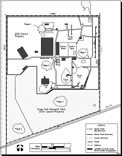
Landfills group (ALPX07) has been used to dispose of sanitary and industrial wastes at the plant since 1942. Twenty-three landfills exist throughout Pantex Plant with a majority being located in Zone 11Zones 11 and 12. Fifteen of these landfills are included in this group (Pantex 1996:15.4). Figure 4.5.1.34 illustrates landfills currently under RCRA Facility Investigation (RFI). VOCs were detected in soils above and adjacent to some of the landfills at various concentrations, up to levels where remediation must be considered. Asbestos and volatile organic compound (VOC)VOCs were detected in soil samples of Landfills 1 and 3 (Pantex 1994a:8-1 to 8-8). Characterization data indicate that NFA is recommended on all landfills except Landfill 3. However, maintenance caps will be placed as needed over selected landfills as a proactive measure to prevent potential water infiltration. Preliminary data packages for Phase I fieldwork were submitted to TNRCC for review in December 1994.
The landfills have been separated into three different groupings: Group I, Landfills 4 and 11; Group II, Landfills 5, 6, 7, 9, 10, 12, and 15; and Group III, Landfills 1, 2, 3, and 13, Original Abandoned Zone 10, and Sanitary Landfills. A recommendation for NFA for Group I Landfills was submitted to the TNRCC on June 28, 1995. A Draft Final RFI recommending NFA for all Group II Landfills was submitted to TNRCC on January 15, 1996. A Draft Final RFI for Group III Landfills is scheduled to be submitted to TNRCC by June 28, 1996. The Draft Final RFI for Group III Landfills will recommend NFA for many of the landfills; Landfill 3 may require additional corrective measures (Pantex 1996:15.4). In situ treatment is being evaluated as a potential option for remediation of residual HE contamination found at Landfill 3 (PC 1996b:1).
The Ditches and Playas group (ALPX08) consists of five playas (Playas 1, 2, 3, 4, and Pantex Lake) and their associated network of man-made ditches. The ditches receive treated wastewater effluent and stormwater runoff from buildings in Zone 11 and 12. Playa 3 receives stormwater runoff from the Burning GroundBurning Ground, and Playa 4 receives stormwater runoff from the south ends of Zones 11 and 12. In the past, Pantex Lake received wastewater effluent from the OSTP. Playa 4 is currently permitted to receive industrial discharges and stormwater runoff from Pantex Plant (Pantex 1996:15.4). Pantex Lake receives neither industrial discharges nor stormwater runoff from Pantex Plant.
This group has been divided into Flow Systems which are described in Table 4.5.1.32. Surface and subsurface soils were collected from various locations throughout the Flow Systems. Table 4.5.1.32 is a summary of the types of contaminants identified from analytical results which exceed the decision criteria (Pantex 1994a:9-1, 9-2). An expedited ICM to remove the hotspots within the ditch SWMUs began in June 1996 (Pantex 1996:15.4). Phase II fieldwork (completed in January 1995) involved collection of surface and subsurface soils from various locations throughout flow systems 1 through 5. Proposed ICMs would lower contaminant concentrations in the ditches. The ICMs scheduled for the summer of 1996 include site-specific removals, in situ remediation, and natural attenuation. A baseline risk assessment is being prepared to evaluate the applicability of Risk Reduction Level 3 closure for those sites that are not candidates for ICMs (Pantex 1996c:53).
Of these five flow systems, only flow systems 1 and 4 have been identified as areas suspected of affecting Zone 12 Groundwater (Argonne, 1995a:3-10). Flow System 1 is divided into four subareas: Flow Pathways 1A, 1B, 1C, and Playa 1 area. Contaminants which exceeded the PRGs in Flow Pathway 1A include an HE (HMX), some inorganics (antimony, lead and selenium), SVOCs, one pesticide (dieldrin), and PCBs. Contaminants exceeding the PRGs in Flow Pathway 1B include various inorganics due to historical discharges from Zones 11 and 12 (mercury exceeded the PRG by 28 to 810 percent at six sampling locations), VOC, SVOCs, and pesticides (including aldrin, 4-4-DDT, and dieldrin). Contaminants which exceeded the PRGs in Flow Pathway 1C include HE (HMX and RDX), various inorganics, SVOCs, pesticides (4-4-DDT and chlordane), and PCBs. Contaminants exceeding the PRGs in Playa 1 include seven inorganics (the most common was chromium, which exceeded the PRG by up to 250 percent at 15 locations), and two pesticides (4-4-DDT, and aldrin). Contaminants detected above the PRGs at Flow System 4 include metals, VOCs, pesticides, and HE. The Ditches and Playas RFI recommends additional sampling at many locations within this grouping to further define the horizontal and vertical extent of contamination (USCOE 1995f:Vol. 1 of 5).
Figure 4.5.1.3-4.--Landfills Currently Under RCRA Facility Investigation.
The Firing Sites group (ALPX09) consists of seven firing sites, located in the north-central portion of Pantex Plant, that have been in operation since 1952. Five of the firing sites are active, and two are currently inactive. The sites have been used for testing of HE in connection with quality control and research and development activities. Some radioactive materials, primarily depleted uranium (DU)depleted uranium (DU), were involved in the testing program. Sampling of soil at Firing Sites 4, 5, and 10 is conducted on an annual basis and is discussed in the following section.
The Pantex environmental restoration (ER)ER program addresses only inactive sites. Active sites are closed under the RCRA permit process. A request has been submitted to Texas Natural Resource Conservation Commission (TNRCC)TNRCC to remove the four active firing sites from the Pantex Plant ER program. An ICM is being conducted on FS5 to remove surface DU contamination. Subsequent confirmation sampling and risk assessment will be conducted at FS5. Confirmation sampling will be conducted to confirm that protective levels have been attained and NFA will be required. Additional hotspot removal will be conducted until the remediation goals have been achieved. FS6 and FS15 contaminant levels were below RRSs and have been proposed to TNRCC for NFA (Pantex 1996:15.3, 15.4; PC 1996b:1).
The Leaking USTs group (ALPX10) is comprised of two gasoline release sites near Buildings 1235 and 161. The USTs were used to store gasoline, diesel, and used motor oil. Five USTs were removed in 1988 from Building 1235, and two USTs were removed from Building 161 in 1989. The Draft Final Corrective Action Plan, submitted to TNRCC in October 1994, proposed NFA based on the fact that contaminant levels were below remediation goals. Benzene levels below the site in the perched aquifer exceed RRS and will be addressed in the Zone 12 Groundwater assessment (Pantex 1996:15.4; PC 1996b:2).
The Miscellaneous Explosive/Radiation Sites group (ALPX11) consists of 12 sites, including a temporary explosives burning site, radioactive residue storage, a subsurface leaching bed, trinitrotoluene settling pits, two high explosive(s) (HE)buildings where explosives were filtered from wastewater, and the soil surrounding an explosive fabrication building. Analytical results from soil samples taken in 1985 near the temporary explosive burning site indicate the following: low concentrations of silver and pesticides at 0, 3, and 4 meters (0, 9, and 14 feet); total organic compounds of 22,600 parts per million at the surface. All radioactive waste staged below ground at Pantex Plant was retrieved and disposed of at an approved DOE burial ground. The decontamination of this site consisted of the removal of the buried radioactive waste, as well as any soil that may have been contaminated by the buried material.
Soil samples were taken before and after site cleanup. Tritium, uranium, and plutonium-239 were detected below the trench before cleanup. Soil analyses subsequent to the cleanup revealed low levels of the same radionuclides (Pantex 1994a:12-1 to 12-2; Pantex 1996:15.4). The vertical and lateral extent of contamination are currently being evaluated. Buildings 1243 and 1224 North are being evaluated for an in situ explosives treatability demonstration. Recent data indicate that explosive contaminants may be degrading naturally as a result of microbial action. Studies are being proposed to define the degradation mechanism and the potential to enhance the process (Pantex 1996c:54).
Twenty-four sites have been identified at Pantex Plant where spills or releases of chemicals have occurred and are referred to as ALPX12, Miscellaneous Chemical Spills and Release Sites. These sites are located within Zones 10, 11, and 12 and areas west of Zone 11. Table 4.5.1.33 summarizes the contaminants of concern (COCs) identified in the soil at ALPX12. No signs of contamination were found at the main electrical substation (AOC No. 2), and TNRCC granted an NFA on the site in September 1993. The primary COCs for the remaining sites include metals, solvents, pesticides/PCBs, and HE. Characterization data are currently under evaluation. Preliminary results indicate that contaminant levels are below RRS 2 and NFA will be required (PC 1996b:1; Pantex 1996c:54; Pantex 1996:15.4).
Supplemental Verification Sites (ALPX13) consists of eight inactive solid waste management unit (SWMU)SWMUs, including five landfills, a barren area where herbicides were applied, parallel depressions, and the old pistol range. The pistol range is still in operation and was removed from the ER program. The Zone 10 abandoned landfill was also removed from this grouping and added to the ALPX7 Landfills investigations. Diesel fuel residuals, hydrocarbon compounds, and dioxins were all detected below RRSs in an area where herbicides were applied near Playa 1. Low levels of volatile organic compound (VOC)VOCs, semivolatile organic compound (SVOC)SVOCs, and pesticides were detected in the depressions in Zone 11Zone 11 below RRSs. Phase I fieldwork was completed in 1993. All sites within this grouping are being considered by the TNRCC for NFA based on the fact that contaminant levels were below remediation goals (Pantex 1996:15.4; Pantex 1996c:55).
ALPX14, the USTs at other RFI locations, consists of areas in Zone 12 where five USTs containing diesel fuel and waste oil were removed. Total petroleum hydrocarbons were detected above TNRCC cleanup level of 500 milligrams per kilogram in surface soils at UST9. All other soil samples collected and analyzed in this unit were within acceptable concentration levels. Phase I fieldwork to remove contaminated soil has been completed and NFA has been recommended for all but UST No. 9. Additional fieldwork will be conducted on this UST, and an in situ treatability demonstration is being conducted (Pantex 1996c:55).
Annual Soil and Sediment SamplingThis section discusses the results of routine and nonroutine (special request) surface soil surveillance at Pantex Plant. The routine soil surveillance program plays an important role in assessing the potential environmental impacts of operations at Pantex Plant. Soil surveillance provides a direct measure of environmental contamination because soil accumulates contaminants that are deposited from the air over time. Thus, soil surveillance allows evaluation of long-term trends. This sampling program is conducted on an annual basis and is separate from the ER programs which deal specifically with SWMU sampling conducted under RCRA and CERCLA as discussed in the previous section.
The following is a summary of the 1994 annual sampling results along with an independent review of these results. The 1995 Environmental Report for Pantex Plant (Pantex 1996) was released in June 1996. The results from the 1995 annual sampling were reviewed and compared to the 1994 results. A summary of the comparison of sampling results is also included in this section.
Soil quality sampling was conducted in 1994 at 17 offsite and 31 onsite soil surveillance locations at the Burning GroundBurning Ground; Firing Sites 4, 5, and 10; and Playas 1, 2, and 3 (refer to appendix I). One of the offsite sampling areas is at Bushland, approximately 55 kilometers (34 miles) west of Pantex Plant and is considered the control sample. These samples were generally collected from playa bottoms and inter-playa uplands. The soil samples were analyzed for radionuclides, metals, explosives, and VOCs; results are presented in appendix I and summarized below.
Soil samples for radionuclides were collected at Firing Sites 4, 5, and 10; the Burning Ground; Playas 1, 2, and 3; and offsite locations. The samples were analyzed for uranium-234, uranium-238, plutonium-239/240, and tritium.
The average 1994 concentrations of plutonium-239/240 were comparable to Bushland averages, indicating that no plutonium-239/240 contamination from Pantex Plant operations is detectable in area soils. Uranium-238 is the most prevalent radionuclide present in the soils at Pantex Plant. Soils at Firing Site 5 exhibited the highest radionuclide activity, which is attributed to high explosive(s) (HE)HE test firings with DU components. Firing Sites 4, 5, and 10 have a low uranium-234 to uranium-238 ratio (0.43 or less), indicating depleted uranium (DU)DU contamination in these areas.
The Burning Ground, Playas 1 and 3, offsite, and Bushland locations have uranium-234 to uranium-238 ratios near 1.0, indicating that no depleted uranium (DU)DU contamination has occurred in these locations. Playa 2 had a uranium-234 to uranium-238 ratio of 0.59, which may indicate DU contamination. Historical averages of uranium-238 and uranium-234 measured at Bushland were 0.74 picocuries per gram and 0.58 picocuries per gram, respectively. The 1994 averages for radionuclide activity at all locations were generally below the historical averages.
Soil samples at the Burning Ground, Playa 3, and Bushland were analyzed for tritium. The average concentrations for tritium were low (0.27 or less) at all locations (Pantex 1996:16.1).
Soil samples for metals were collected at the Burning GroundBurning Ground, Playa 3, and offsite locations. The samples were analyzed for aluminum, boron, cadmium, chromium, cobalt, copper, magnesium, manganese, molybdenum, mercury, nickel, silver, and zinc. All metals were below TNRCC RRS (cleanup levels) and EPA Region III-Risk Based Concentrations (RBCs) with the exception of manganese, which was above RBCs for residential soil. However, manganese concentrations were within the upper limit of background for surface soil (600 milligram/kilogram), with the exception of P3-SS-01 which was slightly higher (640 milligram/kilogram) (DOE 1995b:12-17). All the metals listed above were below industrial standards. RBCs were used for comparison because cleanup levels for manganese do not exist. RBCs are not enforceable standards.
Soil samples for explosives were collected at the Burning Ground, Playa 3, and offsite locations. The samples were analyzed for HMX, RDX, pentaerythritoltetranitrate, and trinitrotoluene. The majority of samples did not have detectable amounts of explosives. Samples that were above detection limits were all below cleanup levels and RBCs (DOE 1995b:12-20, 12-21).
Soil samples collected at Playa 3 and offsite locations were analyzed for VOCs. VOCs were not found at levels above the minimum detection limits (DOE 1995b:12-6). The results of the soil sampling at Pantex Plant and offsite locations do not indicate that deposition of emissions from the Burning Ground activities have substantially impacted the soils.
Average 1995 tritium concentrations were statistically greater than 1994 averages, but were similar to that observed in the control locations. Both uranium 234 and uranium 238 at the Burning Ground were statistically less than the 1994 average concentrations for the same sites. Uranium-234 and uranium-238 at the playa locations were similar to the 1994 ranges of concentrations for the same sites. As in the past, uranium-238 concentrations at the firing sites were higher than concentrations of other radionuclides at Pantex Plant. These higher levels are attributed to the use of DU during test firings of explosives, which ceased in 1986.
The firing sites are scheduled to undergo investigation and remediation under the ER program, and remedial activities have already begun in the area of Firing Site 5. Monitoring data for 1995 are within historic ranges for uranium-238 and uranium-234 at the three firing site areas where samples were collected. Average 1995 concentrations of plutonium-239/240 at all onsite and offsite locations were equivalent to historical and control location averages, indicating no detectable plutonium contamination from Pantex Plant in area soils (Pantex 1996c:12.0).
Results in 1995 for metals at onsite locations were within the expected ranges of concentrations for their soil types, with the exceptions of boron at BGSS05, manganese at several Burning Ground locations (BGSS01, BGSS06, BGSS07, BGSS08, and BGSS09), and zinc at BGSS-01 (Pantex 1996c:12.0).
Overall soil monitoring results for 1995 were within the observed ranges of concentrations for uncontaminated soil and comparable to historical results and those for the control locations. Boron, manganese, zinc, HMX, and total xylene concentrations in the area of the Burning Ground were higher than those at the control locations and the range of concentrations for native uncontaminated soil. However, all observed concentrations were less than those considered to indicate environmental risk. Concentrations of these compounds will be carefully monitored to document any trends during 1996 (Pantex 1996c:170).
4.5.2 Impacts of Proposed Action
4.5.2.1 Impacts of Continued Operations
Weapons Related ActivitiesPantex Plant is located on the northern portion of the Southern High Plains on relatively flat topography. Although erosion is an active process along the northern, eastern, and western margins of the Southern High Plains, it occurs at a rate of only 0.11 meters (0.36 feet) per year. This rate would result in a 1.1-meter (3.6-foot) retreat of the Southern High Plains over 10 years. Weapons-related activities which are mostly confined to Zone 12 and Zone 4Zone 4 do not result in soil erosion. Some soil erosion occurs as a result of agricultural activities on Pantex Plant Site, but these impacts are considered minimal and similar to the rate experienced in the Southern High Plains in general.
Salt dissolution is another active process in the High Plains area. However, no surficial expression of sinkholes or fractures associated with salt dissolution have been identified in Carson County (Gustavson 1981:10). Potential impacts due to subsidence (resulting in sinkholes and/or surface rupture) are considered negligible, because salt dissolution is a slow process relative to human activities (Gustavson 1980).
There are no capable faults identified beneath Pantex Plant. Holocene faulting, however, has occurred on one portion of the Amarillo Wichita-Uplift structure (the Meers fault in Oklahoma) and may have occurred on another part of the same structure in Potter County. This fault is considered to be capable, as defined in 10 CFR 100 Part A. The Wichita-Ouachita Zone includes the Amarillo Uplift and a surrounding Residual Events Zone that includes Pantex Plant Site. Estimated magnitudes for the maximum earthquake for the Amarillo Uplift and the Residual Events Zone are Richter magnitudes of 6.3 and 5.3, respectively.
The maximum credible earthquake of 6.3 magnitude on the Richter scale occurring within a distance of 16 kilometers (10 miles) of Pantex Plant is considered to be an infrequent event having an annual probability of occurrence on the order of 10-3 to 10-4 (Pantex 1996:3.5). The damage due to an earthquake to facilities at Pantex Plant would be dependent on the distance from the facilities to the center of the earthquake, the soil structure beneath the facilities, and the construction of each facility. Damage to facilities may or may not cause a release of materials that could result in health impacts. The potential health impacts from accidental releases of contaminants associated with geological hazards and ability of storage facilities to withstand seismic events are discussed in section 4.14, Human Health.
Releases to the soil from continued operations would result from regulated wastewater discharges, deposition from the Burning Ground emissions, and construction activities. As discussed in section 4.5.1, soil sampling at the Burning GroundBurning Ground does not show any contamination above regulatory action cleanup levels. Significant impacts to the sediments and soils would not occur under normal conditions because the Wastewater Treatment Facility has the capacity to treat wastewater generated from weapons related activities (section 4.6) and air emissions have been calculated to be too small to result in a significant impact (section 4.7.2).
Pit Storage ActivitiesImpacts to pit storage activities due to potential erosion, subsidence, and seismic hazards are the same or less than those addressed for the weapons-related activities. Storage activities do not pose additional impacts to soil and sediment quality under normal conditions because the pits would not come in contact with the soil or sediment. Accident release scenarios are discussed in section 4.14, Human Health.
Environmental Restoration Activities
ER activities pertinent to geology and soils include activities such as soil and sediment sampling, characterization of vertical and horizontal extent of contamination in soils, remediation of soils, and possible removal of contaminated soils. Impacts to the soil as a result of ER activities are predicted to be minimal. Strategies to reduce the amount of waste generated during investigations as well as the amount of waste handled, treated, or disposed of during site cleanups have been implemented. Key points of these strategies include minimizing the amount of waste generated during the RFI by using sonic drilling, hydropunches, geophysical and soil gas survey techniques, and other types of surveys that generate data with minimal waste generation (DOE 1995e:3-7).
Corrective measures will give preference to techniques that do not generate waste or disturb the lands surface topography. Such measures include, for example, in situ bioremediation or capping. Some corrective measures may involve the removal of contaminated soils. In these cases, the waste will be disposed of as described in section 4.13, Waste Management, and excavated areas will be backfilled with clean soil to restore the natural topography. environmental restoration (ER) ER activities are expected to be completed by the year 2000. Impacts to soil and sediment at Pantex Plant are expected to be beneficial.
Waste Management ActivitiesImpacts to soils and sediments at Pantex Plant due to waste management activities are not expected to occur. Waste generated from waste management practices and which come in contact with the sediment and soil are typically nonhazardous. These wastes include treated wastewater from the Wastewater Treatment Facility and construction debris located onsite in a Class 3 landfill. Residuals from the Burning Ground are disposed of in accordance with specifications of the hazardous waste permit. Spills or releases of hazardous wastes and hazardous substances are managed per the Spill Prevention Control and Countermeasures Plan/RCRA Contingency Plan (TWC 1991a). All of these facilities have the capacity to handle these wastes (sections 4.6, Water Resources, 4.7, Air Quality, and 4.13, Waste Management).
4.5.2.2 Impacts of New Facility Construction and Upgrades
Impacts to all new facility construction and upgrades due to potential erosion, subsidence, and seismic hazards would be the same as those addressed in section 4.5.2.1. Temporary soil disturbance for each of the new facilities is summarized in Table 4.5.2.21.
During the operations phase of these projects, impacts to the soil and sediment quality would be negligible. Moreover, existing and proposed treatment facilities will have the capacity to handle all discharges associated with the new facilities.
4.5.2.3 Summary of Impacts
There are no impacts to geology and soil due to the Proposed Action. Temporary disturbance of soil in Zones Zone 1111 and Zone 1212 would occur due to construction activities. Potential impacts to the Proposed Action due to erosion and subsidence (resulting in sinkholes or surface rupture) are negligible. The annual probability of the occurrence of a maximum credible earthquake of 6.3 Richter magnitude within a distance of 16 kilometers (10 miles) from Pantex Plant is on the order of 10-3 to 10-4 (Pantex, 1996:3.5). The potential for a seismic event of this magnitude to result in a release is discussed in section 4.14, Human Health.
4.5.3 Impacts of No Action Alternative
The impacts to geology and soil due to the No Action Alternative are the same or less than those described for the Proposed Action.
4.5.4 Impacts of Pit Storage Relocation Alternative
The Pit Storage Relocation Alternative includes continued operation and maintenance activities at Pantex Plant and transportation and interim storage of pits from Pantex Plant to other DOE and/or Department of Defense facilities. Relocating the pitpits would not impact the geology and soils at Pantex Plant. There would be no impacts to the soil while pits are stored at Pantex Plant prior to relocation because the pits would not come in contact with the soil under normal conditions. Impacts due to erosion, subsidence, and seismic hazards are the same as those described for the Proposed Action.
4.5.5 Cumulative Impacts
The cumulative impacts presented here include impacts of the continued operations at Pantex Plant combined with impacts associated with activities described in the WM PEIS, SSM PEIS, and S&D PEIS. Since the Pantex Plant EIS Proposed Action and the SSM PEIS No Action Alternative represent a continuum of operations, the impacts associated with any new mission or facility that could be implemented at Pantex Plant are discussed in the context of that continuum. The impacts from the WM PEIS program are combined with those of the Pantex Plant EIS Proposed Action. The impacts from the S&D PEIS are combined with those of the SSM PEIS No Action Alternative. A detailed discussion of this methodology is presented in section 4.2.
4.5.5.1 Impacts of Alternatives in the Waste Management Programmatic Environmental Impact Statement
Soil disturbance due to the location of waste management facilities was not addressed in the WM PEIS. However, temporary disturbance of as much as 21.2 hectares (52.6 acres) could occur during the construction phase. Contamination of the soil and sediments are not expected to occur as a result of construction activities.
The WM PEIS determined that there were no programmatic issues that would affect the selection of alternatives for any waste type at Pantex Plant. Future site-wide or project-specific NEPA reviews would be expected to assess such issues as soil erosion, soil characteristics, etc.
4.5.5.2 Impacts of Alternatives in the Stockpile Stewardship and Management Programmatic Environmental Impact Statement
The SSM PEIS includes three alternatives that apply to Pantex Plant: No Action, Downsize Existing Capability, and Relocate Capability. Under the No Action Alternative, no downsizing or modification of facilities would occur, and there would be no construction. Therefore, impacts to soils are expected to remain the same as those from current operations. Under the downsizing alternative, all construction activities would be modifications to existing facilities. Consequently, no significant land disturbance would occur. Under the relocation alternative, decontamination and decommissioning of the facilities would not be expected to have impacts to the soil.
4.5.5.3 Impacts of Alternatives in the Storage and Disposition of Weapons-Usable Fissile Materials Programmatic Environmental Impact Statement
The S&D PEIS is considering Pantex Plant for long-term storage of inventories of nonsurplus weapons-usable plutonium and highly enriched uranium (HEU), storage of inventories of surplus weapons-usable plutonium and HEU pending disposition, and disposition of surplus weapons-usable plutonium. For storage, the strategy for long-term storage of weapons-usable plutonium and HEU, as well as the storage site(s), would be decided. The storage alternatives include upgrading the existing plutonium storage facilities, consolidation of plutonium from other sites, and collocation of plutonium and HEU storage. The collocation alternative is used for analysis purposes in this EIS as the bounding storage alternative.
Under the S&D PEIS Collocation Alternative, construction of new storage facilities would be required in order to store plutonium and HEU at Pantex Plant. No apparent direct or indirect effects on the geologic resources are anticipated, because neither facility construction and operational activities nor site infrastructure improvements would restrict access to potential geologic resources. Soil impacts during operation are expected to be minimal.
For the disposition alternatives in the S&D PEIS, the emphasis at this stage in the NEPA decision process is on choosing the strategy and technology mix rather than the actual site. The evolutionary Light Water Reactor is used for analysis purposes in this EIS as the bounding disposition alternative. Implementation of this disposition alternative would require the construction and operation of a pit disassembly and conversion facility, plutonium conversion facility, MOX fuel fabrication facility, and one or more light water reactors. The bounding alternative also assumes that all of the facilities previously mentioned would be collocated at the same site (potentially Pantex Plant).
No apparent direct or indirect effects on the geologic resources are anticipated, because neither facility construction, operational activities, nor site infrastructure improvements would restrict access to potential geologic resources. The soil erosion potential from direct and indirect impacts associated with construction and operational activities is low for Pantex Plant.
4.5.6 Potential Mitigation Measures
Since there are no impacts to geology and soils, no mitigation measures are required. DOE may choose to implement one or more of the following measures to mitigate the temporary disturbance to soils during construction activities. These measures include erosion control measures such as application of commercial dust suppressants, wind fences for particulates greater than 10 micrometers, sediment traps, diversion of surface water runoff from areas of construction, dikes, silt fences, or covering the disturbed area with rip rap.
|
NEWSLETTER
|
| Join the GlobalSecurity.org mailing list |
|
|
|