


4.4 LAND RESOURCES
4.4.1 Affected Environment
This section discusses land use issues at Pantex Plant and in the surrounding 16-kilometer (10- mile) and 80-kilometer (50-mile) radius areas, hereafter called the Regions of Influence (Region of Influence (ROI)). Particular attention is given to the 16-kilometer (10-mile) ROI in response to extensive public comments on agricultural issues in the areas nearest to Pantex Plant Site. The land use discussion includes agricultural, commercial, residential, industrial, institutional, and public lands. The following subsections characterize the existing land use within and adjacent to Pantex Plant, describe regional and site land use plans and policies, identify any access areas restricted to the public due to Pantex Plant operations, address prime and unique farmland, and identify areas of special interest, such as parks and recreational areas, within the ROIs. See Figure 1.21 for major features within the land resources ROIs.
4.4.1.1 Pantex Plant Land Use
Of the approximately 6,475-hectare (16,000-acre) site, DOE owns approximately 3,683 hectares (9,100 acres) at Pantex Plant and 436 hectares (1,077 acres) of a detached piece of property called Pantex Lake, approximately 4 kilometers (2.5 miles) northeast of the main plant site. Adjacent to the DOE-owned land, approximately 2,347 hectares (5,800 acres) are leased from Texas Tech University (TTU)Texas Tech University (TTU). Pantex Plant activities occur on approximately 809 hectares (2,000 acres) of the 6,475-hectare (16,000-acre) site; the remaining lands are used primarily for safety and security purposes (Figure 1.22). As of April 1995, approximately 2,596 hectares (6,421 acres) of the DOE-owned land were being used by TTU for agricultural purposes through a service agreement. The DOE-owned acreage used for agricultural purposes by TTU is variable and subject to periodic changes. Approximately 23 percent of Pantex Plant land, including that leased from TTU, has been developed for industrial use. There are 76 kilometers (47 miles) of roads located within the Pantex Plant boundaries, and a spur of the Burlington Northern Santa Fe (formerly Atchison, Topeka and Santa Fe) Railroad extends onto the site (Pantex 1996:2.2, DOE 1996e:81).
Historically, Pantex Plant Site was divided into functional areas referred to as "Zones". The only current functional areas that retain this designation are Zone 12, which contains fabrication, assembly/disassembly, technical areas, and administrative support areas; Zone 11Zone 11, which contains the high explosives development area; Zone 10, which serves as an excess property storage site; and Zone 4Zone 4, which includes the weapons/high explosives magazinemagazines and interim pit storage area (see Figure 4.3.1.21).
Currently, the following four Security Control Areas occur over both DOE-owned and leased land: Protected Property Area, Limited Area, Pantex Plant Protected Area, and Material Access Area. The Property Protection Area is the entire 3,683 hectares (9,100 acres) of DOE land and the 2,347 hectares (5,800 acres) of leased TTU land, exclusive of the Pantex Lake area, and is commonly referred to as the "Pantex Plant Site." The remaining three areas are shown in Figure 4.3.1.21 (Pantex 1996:2.2).
Pantex Plant contains several soil types that, according to the Natural Resources Conservation Service (NRCS [formerly, Soil Conservation Service]), have been classified as prime farmland. Prime farmland, unique farmland, and farmland of Statewide or local importance are identified by the NRCS. Prime farmland, as defined in 7 CFR 657, contains the best combination of physical and chemical characteristics for producing crops. This includes cropland, pastureland, rangeland, and forest land. Prime farmlands must have a dependable and adequate water supply from precipitation or irrigation; must be within a favorable climatic zone; have an adequate growing season; a fairly rockless location; and contain an acceptable acidity, alkalinity, and salt and sodium content. These lands usually are protected from flooding and are only moderately erodable with temporary water saturation (Pantex 1996:7.1). These soil types cover the majority of Pantex Plant. The soil types on Pantex Plant are discussed in section 4.5, Geology and Soils.
The Farmland Protection Policy Act (FPPA) (7 U.S.C. ¤¤4201) and the regulations promulgated as a result of FPPA (7 CFR 658) require agencies to make FPPA evaluations part of the NEPA process. The purpose of FPPA is to reduce the conversion of farmland to nonagricultural uses by Federal projects and programs. The Act requires that Federal agencies comply to the fullest extent possible with State and local government policies to preserve farmland. Specifically, FPPA advises that evaluations and analyses of prospective farmland conversion impacts be made early in the planning process before a site or design is selected. Pantex Plant is exempt from FPPA under section 1540(c)(4) (7 U.S.C. ¤¤4201) since the acquisition of Pantex Plant property occurred prior to FPPAs effective date of June 22, 1982.
Pantex lies in the Llano Estacado or Staked Plains portion of the Southern Great Plains. Pantex Plant has a relatively flat topography and is characterized by rolling grassy plains and numerous natural playa basins. This part of the Panhandle is characterized as a semi-arid farming and ranching area. Pantex Plant is surrounded by agricultural land, with several significant industrial facilities located nearby (DOE 1996e:82-83).
Pantex Plant FarmlandA large portion of Pantex Plant is used for grazing cattle and dryland crop production of wheat and sorghum. Cropland is planted under dryland conditions in a winter-wheat/grain-sorghum/fallow sequence that produces two crops every three years within the Pantex Plant boundaries. Grain sorghum and forage sorghum are grown under limited irrigation (on TTU land only) and/or dryland conditions because they are drought resistant. During periods of inadequate rainfall, the TTU property can be irrigated with water from the Ogallala aquifer. In 1994, the plant provided 133 million liters (35 million gallons) of water from the Ogallala well field at Pantex Plant for TTUs onsite use for irrigation and personal consumption (there are only two residences on TTU, so personal usage was limited). About half of the crops grown in the local area are strictly dryland because of the high cost of pumping water from the Ogallala aquifer.
Agricultural chemicals are applied to the Pantex Plant crops in accordance with Pantex Plant Standard 7030 and the Land-Applied Chemical Use Plan. As with other areas in the region, these chemicals have the potential of being transported to the playas through storm water runoff or drift. The chemicals used prior to February 1994 consist of herbicides and insecticides, and their application rates are listed in Table 4.4.1.11 (Pantex 1996:10.2). Pesticide use at Pantex Plant is reviewed annually. Table 4.4.1.12 shows the pesticides allowed for use during the 1996-1997 growing season. This list is updated annually based on current issues (MH 1996c; PC 1996o).
Table 4.4.1.1-1.--Application Rate for Agricultural Chemicals Typically Used at Pantex Plant (.pdf)
Table 4.4.1.1-2.--Agricultural Chemicals for the 1996-1997 Growing Season at Pantex Plant (.pdf)
The TTU property leased to the plant also contains Conservation Reserve Program (CRP) lands which are considered a subset of cropland by the NRCS. CRP is a Federally funded program that allows land owners to place otherwise cultivated cropland in a dormant state for 10 years in return for an annual payment by the government. A grass cover must be planted in the fields to prevent erosion. This program is administered by the Agricultural Stabilization and Conservation Service (Pantex 1996:10.2).
Livestock Grazed on Pantex PlantA large portion of the plant is used for grazing cattle. Stocker calves, which are calves that have been weaned and turned out to pasture, are the most typical livestock operation onsite. Cattle are moved to different areas according to the availability of forage. Grazing is allowed on the uplands and in Playa 4 and Pantex Lake.
Stocking rates at the plant are one animal unit per 2 to 4 hectares (5 to 10 acres) of rangeland, with calves being grazed from November to March on winter wheat (when the weather is conducive to forage production) (Pantex 1996:10.2).
Future Land Use at Pantex PlantFuture land and facility use at Pantex Plant will be managed by DOE through the Land and Facility Use Planning process (DOE P 430.1). This guidance for future site development and reuse is based on the shared long-term goals and objectives of Pantex Plant and stakeholders. The planning process allows for the holistic management of the Departments land and facilities through an integration of missions, ecology, economics, and regional cultural and social factors (DOE 1996h).
Future recommendations at the Plant combine agricultural, industrial/commercial, and open space uses. This includes resource management and livestock grazing. Land resources are expected to remain constant at the plant, with continued leasing of TTU land for security and safety reasons. Pantex Plant has a Site Development Plan that represents the plant upon completion of the projects outlined in the Technical Site Information Five Year Plan (Pantex 1996:10.5, DOE 1995j:8) (Figure 4.4.1.11).
Management plans for the playas and surrounding areas are being implemented as a best management plan to protect cultural and natural resources. This will ensure surface water quality and facilitate compliance with quality requirements for air, water, and natural resources. The plan will also protect archaeological sites and ecological resources (DOE 1996e:81; Pantex 1996:10.5).
Four playas (including Pantex Lake) located on the DOE-owned portion of the site have been designated as wetlands. These wetland areas are of particular concern and are subject to protection under various statutes, regulations, Executive orders and DOE orders. The Interim Guidance Document for Pantex Plant Playas and the Management Plan for Playa 2 Management Unit: Phase One provide additional oversight for the protection of playas. Management plans for Playas 1, 2, and 3 on DOE-owned land have been implemented. These plans will protect the playas by controlling intensive grazing and the plowing of sensitive areas. The following actions are proposed for the approximate 0.4 kilometer (0.25 mile) radius buffer zone surrounding each playa on DOE-owned land:
- Cattle are excluded from Playa Management Units 1, 2, and 3.
- The farmed area within the buffer zone will be planted in native grasses. The entire ecosystem of the playa, both the wetlands and the prairie, will be inventoried, assessed, and allowed to recover from agricultural disturbances (Pantex 1996:10.5).
4.4.1.2 Land Use in the Region of Influence
This section discusses land use within a 16- kilometer (10-mile) and an 80-kilometer (50- mile) radius of Pantex Plant. Urban land use in the Pantex Plant Region of Influence (ROI) is dominated by the Amarillo Metropolitan Area, focusing on the City of Amarillo. Other towns in the ROIs are Borger, Claude, Canyon, Pampa, Panhandle, and White Deer, each with populations under 25,000. The ROIs are transected by Interstate Highways 40 and 27; U.S. Highways 60, 87, and 287; State Highways 136, 207, and 217; and numerous Farm-to-Market roads.
Figure 4.4.1.1-1.--Future Land Usage Projection of Pantex Plant Site Development Plan.
Current Land Use Within a 16-Kilometer Radius of Pantex Plant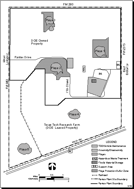
Residences are located throughout the 16-kilometer (10-mile) radius of the plant, with nearly half located to the east, in the town of Panhandle. Another major concentration of residences is located southwest of the plant, in Highland Park Village, which was once associated with the Amarillo Air Force Base. Washburn, located to the south of the Plant, has a somewhat smaller concentration of residences. Within this radius commercial land use is limited to the communities of Panhandle and Washburn, and the Amarillo International Airport. The Iowa Beef Processors Inc., Amarillo Plant, located 10.4 kilometers (6.4 miles) southwest of the center of Pantex Plant, and Fraser Industries, Inc., located 13.3 kilometers (8.3 miles) southwest of the center of the plant make up the areas industrial facilities. Two grain elevators are also located within this area, one to the northeast, the other to the east-southeast of the plant (Pantex 1996:10.3).
Farmland in the 16-Kilometer Region of InfluenceMost of the land surrounding the plant is dryland or irrigated farmland, with farms averaging about 518 hectares (1,280 acres) in size. These farms primarily produce corn, wheat, and sorghum.
Data on 729 gardens within the 16-kilometer (10-mile) radius of the plant were obtained in 1995. These gardens usually contained tomatoes, pumpkins, green onions, peas, corn, okra, squash, cucumbers, leafy vegetables, root crops, and fruit trees. Whether these crops were sold at market was not determined. The largest garden in this area, 54.7 hectares (135 acres), belongs to the William P. Clements correctional facility and is maintained for produce for the inmates of that facility (Pantex 1996:10.2).
Livestock in the 16-Kilometer Region of InfluenceThe herd size of beef cattle (expressed as cow-calf pairs/beef cattle) in the 16-kilometer (10-mile) radius of the plant averages 500 animals or less. As of January 1, 1994 the livestock inventory for Potter and Carson counties was as follows:
- Potter43,000/5,000.
- Carson63,000/5,000.
In a 1995 household survey, only two residents in this area indicated that they had dairy cattle. One individual reported 2,000 cows that were under a year old and not yet producing milk. These cattle were being reared as replacement heifers for sale to other dairy farms. The other resident had six animals that were maintained for personal use (Pantex 1966:10.2). Tables 4.4.1.21 and 4.4.1.22 further discuss the livestock located within a 16-kilometer (10-mile) radius of Pantex Plant.
Land Resources Within an 80-Kilometer (50-Mile) Radius of Pantex Plant
Currently, land within the 80-kilometer (50-mile) radius area is predominately used for agriculture. The largest agricultural area is rangeland that is located along the Canadian River drainage to the north of Pantex and to the south along the tributary drainage of the Red River.
The second largest land use category is irrigated and dryland crops. Commercial, residential, industrial, institutional and public lands comprise a small part of the total land use within this. These areas are predominantly associated with the towns and cities of the region. The City of Amarillo, predominantly a residential area, is the largest urban area in the region. Other major industrial and commercial land areas are associated with the towns of Canyon, Pampa, Borger and Dumas.
Industrial land use within the 80-kilometer (50-mile) ROI includes Pantex Plant and over 60 industrial facilities involved primarily with beef packing, chemical plants, and construction materials manufacturing. Amarillo and the area surrounding it support approximately 20 of these facilities, and the Pampa and Borger areas have 13 facilities. There are 29 grain elevators in the 80-kilometer (50-mile) area (see Table 4.4.1.23) (Pantex 1996:10.1, 10.3).
Table 4.4.1.2-2.--Beef Cattle in a 16-Kilometer(10-Mile)Radius of Pantex Plant (.pdf)
Table 4.4.1.2-4.--Crop Area Within an 80-Kilometer(50-MileRadius)of Pantex Plant, in Acres (.pdf)
Crops and RangelandAgriculture is an important industry throughout the ROI. The settlement pattern associated with agriculture in the Texas Panhandle is characterized by a highly dispersed residential distribution. Farmsteads are usually located along major secondary roadways throughout the rural parts of this area. Information on the predominant crops in the 80-kilometer (50-mile) ROI surrounding Pantex Plant was determined using information from the Texas Natural Resource Information System and crop data from TNRCC. The major crops in the ROI include corn, wheat, sorghum, cotton, soybeans, peanuts, sunflowers, and sugar beets (Table 4.4.1.24).
Crop patterns vary by year and by season, utilizing both dryland or irrigation methods. When irrigated, the water is usually pumped from the Ogallala aquifer or from the playas (Pantex 1996:10.1, 10.2).
LivestockTable 4.4.1.25 shows the beef cattle feedlots, open range cattle, and dairy operations located within a 80-kilometer (50-mile) radius of the plant. The beef cattle industry in the Texas Panhandle has four distinct aspects that are affected by precipitation levels and the local and future market prices for beef. These are:
- Cow-calf operations on open range.
- Grazing of stockers on pasture.
- Feedlot operations.
- Slaughter and meat-packaging operations.
The number of calves grazed on wheat pastures during the winter and spring varies significantly based on how the weather affects wheat growth. The number of cow-calf pairs/beef cows recorded in the January 1, 1994 inventory of Texas Agricultural Statistics for the counties within the 80-kilometer (50-mile) area were as follows: Armstrong, 63,000/5,000; Briscoe, 17,000/9,000; Carson, 73,000/9,000; Castro, 283,000/11,000; Deaf Smith, 681,000/15,000; Gray, 114,000/9,000; Hansford, 251,000/8,000; Hartley, 213,000/6,000; Hutchinson, 40,000/7,000; Moore, 189,000/6,000; Oldham, 79,000/12,000; Potter, 51,000/6,000; Randall, 170,000/9,000; Roberts, 35,000/9,000; Sherman, 159,000/4,000; and Swisher, 212,000/9,000 (Pantex 1996:10.2).
Table 4.4.1.2-6 shows the 20 cattle feedlots located within the ROI by sector. Local market prices, feed yard capacity, transportation costs, available feed, and the condition of the cattle, govern the number of animals in a feedlot at any time. Four dairies are located in the area (see Table 4.4.1.2-7), and the Plains Creamery in Amarillo is the only creamery in the vicinity.
Table 4.4.1.2-6.--Beef Cattle in Feedlots in an 80-Kilometer(50-Mile) Radius of Pantex Plan (.pdf)t
The slaughter and processing end of the livestock cycle is governed by market costs. This being the case, the carcasses of these Panhandle cattle may be shipped to another state for cutting and packaging. It is estimated that over 25 percent of the beef cattle processed in these large operations are consumed by out of state consumers, and that little of this beef returns to the Amarillo area. Conversely, approximately 95 percent of the cattle processed by the small meat processors in the area are consumed locally (Pantex 1996:10.2).
Future Land Use Within the 80-Kilometer (50-mile) Region of Influence
No future land use has been projected by the City of Amarillo or county planning agencies for the majority of land within the 80-kilometer (50-mile) ROI. Based on the City of Amarillos Comprehensive Plan, the population is expected to grow to 195,000 by the year 2005. This will require approximately 2,429 hectares (6,000 acres) of new land, two-thirds of which will be located within the existing city limits (Pantex 1996:10.5; City 1989:6-20, 6-22).
Recreational ResourcesA number of recreation areas and parks are present within the land resources ROI, including Lake Meredith National Recreation Area, Palo Duro Canyon State Park, Buffalo Lake National Wildlife Refuge, Alibates Flint Quarries National Monument, Greenbelt Reservoir, Lake McClellan National Grasslands, and the city parks of Amarillo and Canyon. More information on these areas of special interest may be found in the Land Use chapter of the Pantex Plant Environmental Information Document (Pantex 1996:10.6).
Other Land ResourcesAll other land uses are classified as commercial, residential, industrial, institutional, and public lands and comprise only a small part of the total land uses within the ROI. The ROI has 134 primary and secondary schools as well as 6 institutions for higher learning. Amarillo is the medical center for the panhandle region, with 5 hospitals. Additional hospitals are located in the towns of Canyon, Borger, Pampa, and Dumas. The nine-county region also has a total of 27 nursing/convalescent homes that care for the needs of the elderly (Pantex 1996:10.4).
Pantex Plant maintains a full-time capability to respond to any medical, fire, or hazardous materials emergencies that may occur at the plant. Fire departments with full-time and/or volunteer staff are located in the City of Amarillo, and the towns of Borger, Canyon, Channing, Claude, Pampa, Panhandle, Stinnett, Vega, and White Deer.
Commercial areas in the Amarillo metropolitan area are located in the central business district, at major shopping centers and malls, and along major streets in the form of strip development.
4.4.2 Impacts of Proposed Action
4.4.2.1 Impacts of Continued Operations
Weapons-Related ActivitiesImpacts to land resources at Pantex Plant as a result of the weapons-related activities planned under the Proposed Action are expected to be limited. Operations under the Proposed Action would not appreciably change current land use at Pantex Plant; therefore land resources would not be adversely affected.
Pit Storage ActivitiesThe storage of 20,000 pits planned under the Proposed Action would use existing storage space in Zone 4Zone 4. Therefore, no land resources, including agriculture, floodplains, and wetlands, would be affected.
Environmental Restoration Activitiesenvironmental restoration (ER)Environmental restoration activities will have a long-term impact on land resources. Some remediation activities (e.g., soil removal) may temporarily restrict the use of land resources but the cleaned-up lands would then be available for other uses.
Waste Management ActivitiesWaste management activities would not use any additional land under this alternative than is currently used. Impacts are therefore considered negligible.
4.4.2.2 Impacts of New Facility Construction and Upgrades
Under the Proposed Action, six facilities are to be constructed or modified in or adjacent to Zone 11Zones 11 Zone 12and 12, in areas that have been previously disturbed. The area required for these facilities is provided in Table 4.4.2.21. The total area required for these projects amounts to 15,902 square meters (171,160 square feet), which is 0.04 percent of the DOE-owned property on Pantex Plant Site. Impacts on land resources are therefore considered negligible.
4.4.2.3 Summary of Impacts
Continued operations at Pantex Plant would not disturb any new lands; land disturbed by the construction of the new facilities under the Proposed Action amounts to 0.04 percent of the DOE-owned property on Pantex Plant Site. Additional impacts to agriculture and industry in the ROI are not anticipated. Impacts on land resources are therefore considered negligible.
Table 4.4.2.2-1.--Proposed Facility Construction and Modification for the Proposed Action (.pdf)
4.4.3 Impacts of the No Action Alternative
Impacts to land resources at Pantex Plant as a result of continued operations, environmental restoration (ER)environmental restoration, and waste management under the No Action Alternative are expected to be similar to or less than those identified for the Proposed Action. Under the No Action Alternative discussed in section 3.1.2, no new facilities would be constructed. Activities associated with the No Action Alternative would not create any significant impact to land resources.
4.4.4 Impacts of pitPit Storage Relocation Alternative
As discussed in section 3.1.3, the Pit Storage Relocation Alternative would involve relocation of pits from storage at Pantex Plant to storage at one or more alternate sites. Activities at Pantex Plant Site would remain similar to those identified for the Proposed Action, including the construction of six new facilities. Impacts on land resources would, therefore, be similar to those identified for the Proposed Action.
4.4.4.1 Impacts of Relocating 20,000 Pits
The interim storage of up to 20,000 pits at other DOE or Department of Defense sites would make the current storage facilities in Zone 4Zone 4 available for other uses. No land use change is anticipated.
4.4.4.2 Impacts of Relocating 8,000 Pits
The interim storage of up to 8,000 pits at other DOE or Department of Defense sites would make some of the current storage facilities in Zone 4 available for other uses. No land use change is anticipated.
4.4.5 Cumulative Impacts
The cumulative impacts presented here include impacts of the continued operations at Pantex Plant combined with impacts associated with activities described in the WM PEIS, SSM PEIS, and S&D PEIS. Since the Pantex Plant EIS Proposed Action and the SSM PEIS No Action Alternative represent a continuum of operations, the impacts associated with any new mission or facility that could be implemented at Pantex Plant are discussed in the context of that continuum. The impacts from the WM PEIS program are combined with those of the Pantex Plant EIS Proposed Action. The impacts from the S&D PEIS are combined with those of the SSM PEIS No Action Alternative. A detailed discussion of this methodology is presented in section 4.2.
4.4.5.1 Impacts of the Alternatives in the Waste Management Programmatic Environmental Impact Statement
In conjunction with the Proposed Action, the location of treatment and disposal facilities as described in the WM PEIS could increase land use by a maximum of 10.6 hectares (26.3 acres) at Pantex Plant Site. Cumulative impacts on land resources would not be considered significant. Moreover, this land is already DOE-owned. The new requirements would not be in conflict with DOE plans and policies or the plans and policies of the local governments in the Pantex Plant vicinity.
4.4.5.2 Impacts of Alternatives in the Stockpile Stewardship and Management Programmatic Environmental Impact Statement
The SSM PEIS includes three alternatives that apply to Pantex Plant: No Action, Downsize Existing Capability, and Relocate Capability. Under the No Action Alternative, no downsizing or modification of facilities would occur, and there would be no change in land use. Under the downsizing alternative, facilities would be consolidated and impacts would be expected to be less than current impacts. Under the relocation alternative, the Pantex Plant facilities would be decommissioned and no longer active.
4.4.5.3 Impacts of Alternatives in the Storage and Disposition of Weapons-Usable Fissile Materials Programmatic Environmental Impact Statement
The S&D PEIS is considering Pantex Plant for long-term storage of inventories of nonsurplus weapons-usable plutonium and highly enriched uranium (HEU), storage of inventories of surplus weapons-usable plutonium and HEU pending disposition, and disposition of surplus weapons-usable plutonium. For storage, the strategy for long-term storage of weapons-usable plutonium and HEU, as well as the storage site(s), would be decided. The storage alternatives include upgrading the existing plutonium storage facilities, consolidation of plutonium from other sites, and collocation of plutonium and HEU storage. Potentially, pits could be stored in Zone 12 for long-term storage. The Collocation Alternative is used for analysis purposes in this EIS as the bounding storage alternative.
Under the S&D PEIS Collocation Alternative, construction of new storage facilities would be required in order to store plutonium and HEU at Pantex Plant. Although the new construction would convert undeveloped land, the proposal would conform with the Pantex Site Development Plan. Therefore, direct effects to land use would be negligible. Land disturbance would be 89.5 hectares (221 acres) during construction and 87 hectares (214 acres) during operations.
For the disposition alternatives in the S&D PEIS, the emphasis at this stage in the NEPA decision process is on the strategy and technology mix rather than the actual site. The evolutionary Light Water Reactor (LWR) is used for analysis purposes in this EIS as the bounding disposition alternative. Implementation of this disposition alternative would require the construction and operation of a pit disassembly and conversion facility, plutonium conversion facility, mixed oxide (MOX) fuel fabrication facility, and one or more light water reactors. The bounding alternative also assumes that all of the facilities previously mentioned would be collocated at the same site (potentially Pantex Plant).
Land disturbance during construction would be 14 hectares (35 acres) for the pit disassembly and conversion facility, 36 hectares (90 acres) for the plutonium conversion facility, 121 hectares (300 acres) for the MOX facility, and 284 hectares (700 acres) for the evolutionary LWR. Land required for operations would be 12 hectares (30 acres) for the pit disassembly and conversion, 28 hectares (70 acres) for the plutonium conversion facility, 81 hectares (200 acres) for the MOX facility, and 138 hectares (341 acres) for the evolutionary LWR. The evolutionary LWR would be located on land which is in agricultural use in the northwest portion of Pantex, west of the Burning Ground and Zone 5. Construction of the evolutionary LWR would change current agricultural land use (DOE 1996j:S-11, S-130, 131).
Because this proposed action is not part of the Site Development Plan, a potential adverse direct impact to land use could occur. It should be noted that preconstruction activities for disposition would require about 5 years to perform the tiered NEPA analyses and to obtain necessary permits and designs. About another 5 years would be required for construction, startup, preoperational testing, and operational readiness review. Construction of completely new reactors could take longer (DOE 1996a:chapter 4).
4.4.6 Potential Mitigation Measures
Since no long-term adverse impacts to land resources have been identified relative to the Proposed Action, No Action, or the Pit Storage Relocation Alternatives, no mitigation measures are needed.
|
NEWSLETTER
|
| Join the GlobalSecurity.org mailing list |
|
|
|