


4.6 WATER RESOURCES
4.6.1 Affected Environment
This section describes the water resources at and in the vicinity of Pantex Plant. The discussions include identification of prominent surface water features, hydrologic characteristics, floodplains, baseline surface water quality, surface water usage, and surface water rights and permits. Also included are discussions of hydrogeologic characteristics of unsaturated materials and water-bearing units (aquifers); baseline groundwater quality of regional and local aquifers; onsite and offsite groundwater usage; and groundwater rights, agreements, and allocations.
The Region of Influence (ROI) for water resources includes Pantex Plant and the surrounding area that could be impacted by plant operations. The ROI for surface water is the onsite playas and ditch system, and the floodplains delineated by the U.S. Army Corps of Engineers (COE), as discussed in section 4.6.1.1. The ROI for the perched aquifer is based on the extent and migration of contaminants, and is discussed in detail in section 4.6.1.2. Although the ROI for the Ogallala aquifer has not been quantifiably defined, it includes the recharge area and is limited by the extent of drawdown in Pantex Plant wells. The ROI for the Ogallala aquifer is graphically depicted in Figure 4.6.1.21.
The discussion of water quality, while including naturally occurring compounds, is mainly concerned with the existence of, and potential for, contamination. Pantex Plant operations have been ongoing since 1951. Over the years, wastes generated from site-related production activities were released, or discharged, at the ground surface to soils, sediment, and surface water. Infiltrating rainwater, stormwater runoff, and other water discharged on the ground surface has moved the contaminants resulting from past discharges downward toward the groundwater. As a result, contaminants that were released at the ground surface over the past 40 years have moved downward and affected the water quality in the uppermost water-bearing zones, known as perched aquifers, where they exist beneath Pantex Plant. DOE is investigating the potential for contaminant migration to the Ogallala aquifer from Pantex Plant in homestead wells that are located southeast of the plant boundary.
Although the low levels of high-explosive(s) (HE) contamination have been detected in a domestic Ogallala well located on private property southeast of Pantex Plant proper, efforts to mitigate further contamination have been completed. The well in question has been properly plugged and sealed under the supervision of TNRCC and a replacement Ogallala well has been drilled and completed in order to prevent further potential cross-contamination of the Ogallala aquifer. Pantex Plants Groundwater Protection Project addresses these and future steps to assure the integrity of offsite groundwater quality (section 4.6.1.2) (MH 1996a).
Since the late 1980s, wastestreams (liquid and solids) generated in the actual production activities at Pantex Plant have been reworked to greatly reduce the amount of contaminants in current discharges. As a result of enhanced industrial wastewater treatment practices, the potential for surface water contamination from wastewater discharges has been greatly reduced. Pantex Plant has worked very closely with Environmental Protection Agency (EPA) Region 6 and TNRCC to produce wastewater discharge permits (EPA National Pollutant Discharge Elimination System [NPDES] Permit No. TX-0107107 and TNRCC Wastewater Discharge Permit No. 02296) that provide stringent wastewater discharge requirements that are protective of human health and the environment. Pantex Plants Environmental Protection Department conducts environmental monitoring on a routine basis. The results of environmental monitoring activities are summarized and presented in annual environmental reports that are available to the public.
The potential spread of the contamination in the groundwater from historical site-related activities is influenced by the physical and chemical characteristics of the soil and the underground materials, the presence and flow of groundwater, and the remediation efforts that are planned or underway. This section describes these factors and existing water contamination.
4.6.1.1 Surface Water
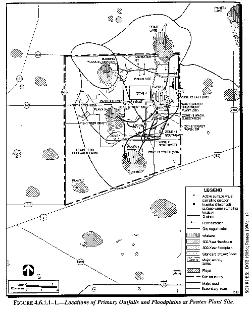
HydrologyThere are no streams or rivers at or in the vicinity of Pantex Plant; all site water needs are met by groundwater (DOE 1995k:4-292). Six playas are associated with the Pantex Plant Site. Playas 1 through 3 are located on Pantex Plant proper. Playas 4 and 5 are on the property DOE leases from Texas Tech University (TTU)Texas Tech University (TTU). Playa 1 contains water throughout the year. Playas 2 through 5 are dry most of the year. Pantex Lake (the sixth playa) is located approximately 4 kilometers (2.5 miles) northeast of the main site. Pantex Lake does not receive runoff from the plant and is dry most of the year. The only major stream in the area is the Canadian River, which is located approximately 40 kilometers (25 miles) north of Pantex Plant. Since surface runoff at the plant flows into local playa basins, the Canadian River is not affected by activities at Pantex Plant. Most of the surface drainage within the plant is directed to the playas via several major drainage ditches, as shown in Figure 4.6.1.11.
Playa 1 receives continuous discharges from the Pantex Plant Wastewater Treatment Facility (WWTF). Only in the ditch running from the WWTF to Playa 1 does flow occur throughout the year, at approximately 950,000 liters (250,000 gallons) per day (Pantex 1996:5.2.2, 5.2.3). All effluents from plant operations are treated and, along with some noncontact industrial discharges, are directed into ditches that drain into Playas 1, 2, and 4 (Pantex 1996c:111). Playa 3 receives stormwater runoff from the urning GroundBurning Ground. Current Pantex Plant activities do not involve Playa 5 or Pantex Lake. However, wastewater from Pantex Plant was discharged to Pantex Lake from 1942 through 1987. Playa 5 has received wastewater from numerous sources other than Pantex Plant in the past (Pantex 1989:223).
Playas are a significant part of the surface and subsurface hydrologic systems at Pantex Plant. All playas at the site receive stormwater runoff from the Pantex Plant vicinity. The playas have also been identified as possible sources of focused recharge to the groundwater flow system at Pantex Plant. Unlined ditches have been used to convey wastewater and stormwater in the past. This practice continues today; however, the water quality and outfalls are subject to the conditions of surface water discharge permits and permit limits. Unlined ditches transmit treated waters or stormwater from discharge points at Pantex Plant to Playas 1, 2, and 4. These unlined ditches and areas away from the ditches are believed to be additional sources of groundwater recharge (Pantex 1996:4.5.1). Recharge to the area aquifers is not fully understood. Investigations of the ditches and playas, related to the potential for contamination, are being performed through the Pantex Plant environmental restoration (ER)environmental restoration (ER) program. Current corrective measures include preventing further migration of contamination by identifying and removing contaminated soils along the ditches to Texas Risk Reduction Standards (RSS) (Stroller 1996:1-1).
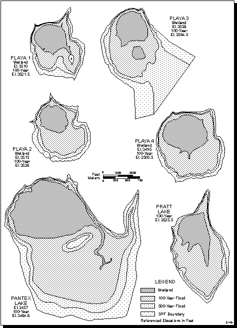
FloodplainsFloodplains at Pantex Plant were delineated by the Tulsa Office of U.S. Army Corps of Engineers (COE)COE in accordance with Executive Order 11988 (EO 11988:804; 44 FR 1022:B.7-2). This assessment also fulfills the environmental review requirements under Compliance with Floodplain/Wetlands Environmental Review Requirements (10 CFR 1022). Although not formally stated there, the Notice of Intent to prepare this EIS (59 FR 26635) was the Notice of Floodplain/Wetlands Involvement. Locally intense rainfall can cause stormwater runoff and ponding in the playa basins (LLNL 1988:3-1). The COE delineated floodplain boundaries for Playas 1 through 4, Pantex Lake, and Pratt Lake (located north of Pantex Plant), using criteria for 100-year, 500-year, and Standard Project Flood boundaries. Detailed floodplain delineations at Pantex Plant are shown in Figure 4.6.1.12. Flood frequencies and their corresponding peak flood elevations as calculated by COE are provided in Table 4.6.1.11.
Except for Playa 3, the floodplains are within the drainage boundary for each playa. The 500-year and Standard Project Flood runoff into Playa 3 will overflow out of the drainage basin creating shallow (less than 30 centimeters [1 foot]) flooding of the drainage basins for Playas 1 and 2 (DOE 1995c:2). The elevations of the Burning Ground structures were not included in these floodplain studies, but have been included in Table 4.6.1.11 for informational purposes. The only structures that currently exist above land surface at the Burning Ground are the explosive burn trays (USCOE 1995:2-6, 2-7). These structures have a height of 0.6 meters (2 feet) above ground surface and an approximate surface elevation of 1,089 meters (3,572 feet) above mean sea level. The explosive burn trays are outside of the 100- and 500-year delineated floodplains for Playa 3, and are therefore, in compliance with 40 CFR 264.18 (Location Standards for Floodplains).
Surface Water QualitySurface water monitoring is conducted at Playas 1 through 4 and at Pantex Lake. In addition, offsite surface water quality control samples (used as background samples) were collected from Bushland Playa, located 54 kilometers (34 miles) west of the plant, for comparative purposes (Pantex 1996c:111). Surface water quality sampling was conducted at the locations shown in Figure 4.6.1.11 for a full suite of analytical parameters including radionuclides, metals, high explosive(s) (HE)HE, polychlorinated biphenyls (PCBs), pesticides, herbicides, volatile organic compound (VOC)volatile organics, semivolatile organic compound (SVOC)semivolatile organics, and other miscellaneous constituents and field parameters. Table 4.6.1.12 gives the current and historic sources of flow for each monitoring location. Analytical water quality sampling results are presented in volume II, appendix C.
Pantex Plant conducts effluent monitoring at designated sampling locations in accordance with the requirements of the NPDES Permit (EPA 1996) and TNRCC Wastewater Discharge Permit (TNRCC 1996b). Flow from the WWTF is small but continuous. The NPDES Permit specifies a daily average discharge limitation for Outfall 001 of 2.5 million liters (0.65 million gallons) per day. Environmental surveillance monitoring is conducted at the other sampling locations when surface water is present (usually after rainfall). Surface water samples are analyzed for both radiological and nonradiological constituents.
Figure 4.6.1.1-1.--Locations of Primary Outfalls and Floodplains at Pantex Plant Site.
Figure 4.6.1.1-2.--Detailed Floodplain Delieations for Playas 1-4, Pantex Lake, and Pratt Lake.
Table 4.6.1.1-1.--Flood Frequencies with Corresponding Elevations, Pantex Plant (.pdf)
Table 4.6.1.1-2.--Surface Water Monitoring Stations and Sources of Flow at Pantex Plant Site (.pdf)
Sampling locations, water quality parameters measured, and sampling frequency may change from one year to the next. Detailed information on surface water quality monitoring is summarized in annual environmental reports prepared for Pantex Plant. Results from 1994 surface water sampling confirm that Pantex Plant was in compliance with all regulations regarding discharge water quality (DOE 1995b:11-1, 11-35). There were Texas Natural Resource Conservation Commission (TNRCC)no exceedances of the Quality Levels for Inland Waters as established by 30 TAC 319.29 (Pantex 1996c:150). With the exception of a high water level in Playa 1 in May and June 1995 due to rainfall events, all the requirements of the TNRCC Permit No. 02296 were met (Pantex 1996c:150). The high water level does not present a problem to the environment or human health.
Surface water quality samples from 1994 and 1995 that were tested for radionuclides were less than the DOE derived concentration guides for ingested water established by DOE for radiation protection of the public and the environment (DOE Order 5400.5). DOE is self-regulating with respect to standards and requirements for radiation. The Atomic Energy Act of 1954, as amended, authorizes DOE to protect public health and safety and the environment in conducting programs, such as Pantex Plant operations. The DOE derived concentration guide values given in DOE Order 5400.5 are reference values for radiological protection programs at operational DOE facilities. Even though no derived concentration guides exist for gross alpha/beta, results indicate that 1995 radionuclide levels in surface water were similar to historical levels, levels at the control location, and levels in water from the Ogallala aquifer. Thus Pantex Plant operations do not affect the radiological content of discharged waters (Pantex 1996c:111).
As at any 50-year old industrial facility, a variety of constituents are occasionally detected at very low concentrations. The semivolatile organic, 3,3-dichlorobenzadine, and the HEs PETN, RDX, and TNT were detected in surface water quality samples from Playa 1 in 1993, but were not detected in surface water samples collected at this location in 1994. No PCBs, pesticides, or herbicides were detected in 1995. In Outfall 002, the HE HMX (0.047 mg/L) was detected in September and the HE RDX was detected in June and July 1995 (0.28 mg/L and 0.13 mg/L, respectively). Water quality data from 1990 through 1994 are summarized in volume II, appendix C.
In addition to the routine surface water monitoring described above and presented in volume II, appendix C, additional surface water, surface soil, and subsurface soil samples were collected as part of the Ditches and Playas Flow System 1 Resource Conservation and Recovery Act (RCRA) Facility Investigation (RFI) (USCOE 1994a:ES-4). Surface water samples were collected from Playa 1 (Flow System No. 1). The following five suspected contaminants were identified in the U.S. Army Corps of Engineers (COE)COE Preliminary RFI Report: chromium, lead, phosphorous, 4,4-DDT, and heptachlor. Of these, only two, lead and phosphorous, were determined to be statistically significant. Elevated lead levels may be associated with the historical routine use of leaded gasoline in plant vehicles. Studies are currently being conducted to establish an industrial background for lead. Elevated phosphorous levels are assumed to be associated with onsite agricultural fertilizer usage.
Surface Water UsesPlayas at Texas Tech University (TTU)TTU Research Farm are periodically used for grazing livestock, but not on DOE-owned property. This is discussed in section 4.4.1.1 (Pantex 1996:5.5). In addition to the grazing operations, some areas of Pantex Plant are cultivated. Water for irrigation is used only on the TTU Research Farm, and when used, it is potable water pumped from the Ogallala aquifer. Water for irrigation of TTU land is pumped from five Pantex Plant wells and is sold to TTU under an interagency agreement between TTU and DOE (PC 1996v). There is no irrigation of DOE property.
Surface Water Discharge PermitsPantex Plant is required to conduct all operations in compliance with the water resource permits listed in Table 4.6.1.13. These permits include NPDES Permit No. TX-0107107, TNRCC Wastewater Discharge Permit No. 02296 as amended, NPDES General Stormwater Discharge Permit TXR00G138, and a Clean Water Act (33 U.S.C. 1251) Section 404 Dredge and Fill Permit (EPA 1996; TNRCC 1996b; EPA 1995; USCOE 1994). Each of these surface water permits are discussed below.
Table 4.6.1.1-3.--Water Resource Permits Issued to Pantex Plant (.pdf)
NPDES Permit No. TX-0107107. In 1990, Pantex Playas 1, 2, 3, 4, and Pantex Lake were determined to be jurisdictional wetlands by COE, and are therefore considered to be waters of the United States subject to protection by the NPDES. EPA Region 6 NPDES Permit No. TX-0107107 authorizes Pantex Plant to discharge to the waters of the United States, under specified effluent limitations and monitoring requirements (EPA 1996). Pantex Plant discharges treated domestic and industrial wastewater into ditches and Playas 1, 2, and 4 under the terms and conditions of this permit. The discharge from Pantex Plant is directed into four playa lakes adjacent to the watershed of McClellan Creek (about 8 kilometers [5 miles] to the east), which flows into the North Fork of the Red River (Waterbody Segment Code No. 0224 of the Red River Basin). There are no known surface water connections that could transport potential contaminants from Pantex Plant into the Canadian River. Due to the flat, level topography of Pantex Plant, streams are not well developed on the landscape and surface waters drain to the playa basins.
The NPDES permit has daily average and daily maximum effluent volume limitations of 2.5 and 3.1 million liters (0.65 and 0.82 million gallons) per day respectively for Final Outfall 001. Effluent is regulated in the NPDES Permit for the following parameters or chemical constituents at one or more outfalls:
- Metals - antimony, arsenic, beryllium, cadmium, chromium, cobalt, copper, cyanide (total and amenable), lead, manganese, mercury, molybdenum, nickel, selenium, silver, thallium, titanium, and zinc;
- HEs - HMX, RDX, PETN, and TNT; and
- Miscellaneous Water Quality Parameters - ammonia, biochemical oxygen demand, chemical oxygen demand, oil and grease, pH, total suspended solids, and total dissolved solids.
Effluent permit limits vary per outfall. Specific NPDES permit requirements are tabulated in volume II, appendix C (Table C.1.22). The requirements and limitations specified in this NPDES permit formed the basis for amendments to TNRCC Permit 02296.
TNRCC Permit No. 02296. Historically, Pantex Plant discharged treated domestic and industrial wastewater into ditches and Playas 1 and 2 under the terms and conditions of TNRCC Wastewater No-Discharge Permit 02296, first issued on May 19, 1980 and renewed and modified on May 3, 1988. The term "No Discharge" referred to the playa lakes at Pantex Plant not being considered waters of the State of Texas by the State at the time of permit issuance. Recently TNRCC Permit 02296 was amended (effective June 14, 1996) and generally reflects the same effluent limitations and requirements as the EPA Region 6 NPDES Permit that became effective on June 1, 1996.
Pantex Plant has worked very closely with EPA Region VI and TNRCC to produce wastewater discharge permits (EPA NPDES Permit No. TX-0107107 and TNRCC Wastewater Discharge Permit No. 02296) that provide stringent wastewater discharge requirements that are protective of human health and the environment. The Pantex Plant wastewater discharge permit limits meet or exceed all current regulations that apply to surface water. Since the State of Texas applies regulations through the concentration limits specified in permits, the decision criteria for surface water compliance is based on the permit limits established in the NPDES Permit and Wastewater Discharge Permit for Pantex Plant. EPA and TNRCC determined which constituents would have reporting requirements and/or permit limits specified in the NPDES and Wastewater Discharge permits based on a review of the most recent surface water quality data available for the main outfalls and internal outfalls. The most recent analytical data at the time of regulatory review were from 1993. TNRCC calculated effluent limitations that were based on the Texas State Surface Water Quality Standards (Title 30 TAC 307). The actual effluent limitations, cited in the permits, are more stringent than those calculated by TNRCC and reported in its Fact Sheet (TNRCC 1995a). As stated in the NPDES Permit, EPA has accepted the statistical calculations provided by Pantex Plant and has established metal limitations on a case-by-case basis through best professional judgment under 402 (a) of the Clean Water Act for best available technology economically available.
The Pantex Plant Environmental Protection Department conducts environmental monitoring to assure that all regulated surface water outfall discharges are in compliance with the established permit limits. In addition to the constituents that are regulated in the permits, the Pantex Plant Environmental Protection Department also has conducted analyses for the following constituents that were not specified in the permit: nitrite, strontium, vanadium, 4-methylphenol, 3,3-dichlorobenzidine, acetone, benzoic acid, chloroform, ethylbenzene, methylene chloride, phenol, toluene, xylene, boron, and tin. By monitoring for these additional constituents, Pantex Plant is providing additional assurance that any changes in chemical constituents and their relative concentrations are protective of human health and the environment.
TNRCC Wastewater Discharge Permit No. 02296 (as amended) requires that within one year of the effective date of the permit (June 14, 1996), Pantex Plant must conduct a study (which is currently underway) that determines the feasibility of eliminating or minimizing discharges to playa lakes and open ditches or improving the quality of discharge. According to the permit, the study should, at a minimum, include the following proposals:
- Upgrading existing treatment facilities or constructing new treatment facilities to ensure no groundwater quality effects from discharges to playa lakes and ditches;
- Constructing synthetically-lined impoundments to confine treated effluent and a closed collection system from all process areas to the treatment facilities;
- Establishing an irrigation disposal site and accompanying disposal practices plan to eliminate discharges to the playa lakes;
- Establishing a reuse and conservation program for all process wastewaters, thereby eliminating any industrial effluent discharge to the playa lakes and ditches; and
- Developing a schedule for completion of proposals or any other proposals deemed feasible by the permittee.
NPDES General Stormwater Discharge Permit TXR00G138. EPA issued a Stormwater General Permit Coverage Notice on February 15, 1995. Additionally, Pantex Plant has filed Notices of Intent for Stormwater Discharge Associated with Construction Activities for individual construction projects that disturb 2 hectares (5 acres) or more.
Clean Water Act Section 404 Dredge and Fill Permit. This permit, issued by COE, was required for previous field activities conducted for hydrogeologic site characterization. Since these site characterization efforts have concluded, the permit was allowed to expire without renewal.
4.6.1.2 Groundwater
Assessment of the affected environment for groundwater resources consists of the following factors. Hydrogeologic properties are characterized to determine the presence and flow characteristics of aquifers, or water-bearing units, beneath Pantex Plant. The physical and chemical properties of soils and subsurface sediments, coupled with the occurrence and flow characteristics of the aquifers, are controlling factors in determining how potential contaminants discharged at the ground surface can migrate into subsurface materials, the presence or probable absence of contamination in groundwater, and the potential for contaminant movement in or between aquifers.
Characterization of the existing (baseline) water quality is necessary to determine the current extent of contamination and to determine how the actions proposed in this EIS may impact the current water quality conditions. The potential impacts to the existing water quality from the Proposed Action are discussed in section 4.6.2. It is important to note and to distinguish between the existing water quality conditions that have been affected by over 40 years of Pantex Plant operations and the associated waste generation versus the water quality of treated wastewater discharges that are currently entering the system.
Past discharges contained what is regarded under todays standards as unallowable amounts of contamination. Since 1980, wastestreams generated from the production activities have been reworked to greatly reduce the potential for contaminants to be discharged. As discussed in section 4.6.1.1, surface water discharge permits have been in effect since 1980, and all future discharges that occur at Pantex Plant will need to be in compliance with the plants Texas Natural Resource Conservation Commission (TNRCC)TNRCC and EPA permits. Current groundwater uses and groundwater rights and permits are discussed to provide a general background of groundwater availability and will be used for assessment of impacts in section 4.6.2.
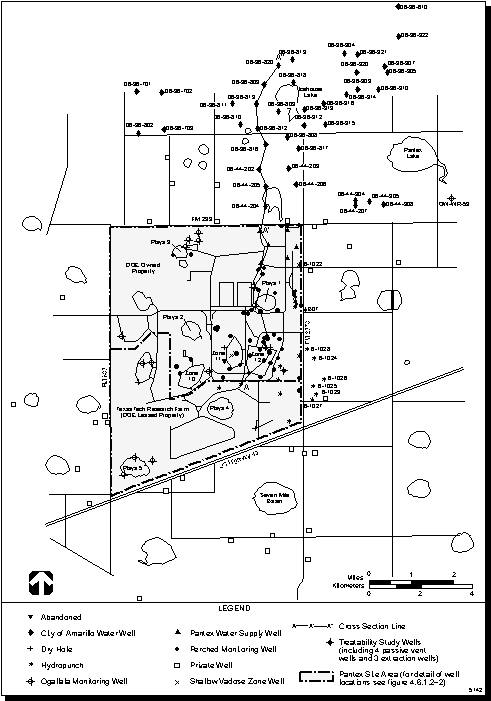
HydrologyGroundwater provides the primary water supply for the High Plains area, a major agricultural region of the United States. The High Plains aquifer, commonly called the Ogallala aquifer, underlies the whole of the Texas Panhandle and the South Plains, as well as parts of New Mexico, Oklahoma, Colorado, Kansas, Nebraska, Wyoming, and South Dakota. The Ogallala aquifer is the principle aquifer and major source of water in the vicinity of Pantex Plant and the surrounding ROI. The locations of private and municipal supply wells in the vicinity of Pantex Plant are shown in Figure 4.6.1.21. A hydrogeologic feature that occurs locally at and in the vicinity of Pantex Plant are perched aquifers; these features form due to the presence of low-permeability materials that impede and may even prevent the downward migration of infiltrating water (Pantex 1996:4.1). Perched groundwater in Zone 12 is the uppermost water-bearing unit that has been affected by Pantex Plant activities.
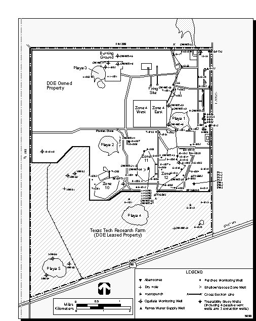
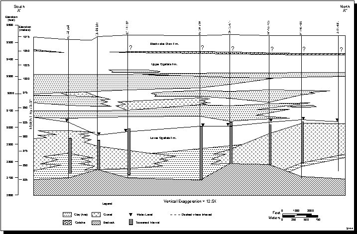
Hydrogeologic site characterization activities to establish baseline conditions are underway as a component of the sites ongoing environmental restoration (ER)ER program. The Texas Bureau of Economic Geology (Texas A&M University) conducted extensive characterization studies at Pantex Plant from 1990 to 1995. Recent and ongoing hydrogeologic field investigations currently are being conducted by Battelle-Pantex and U.S. Army Corps of Engineers (COE)Argonne National Laboratory. These field investigations include the installation of several new wells and test borings, the collection of additional groundwater level measurements, aquifer testing, and groundwater quality sampling. The locations of existing Pantex Plant wells are shown in Figure 4.6.1.22. A north-south trending hydrogeologic cross-section is shown in Figure 4.6.1.23.
Pantex Plant is underlain by the following hydrogeologic units (from the ground surface downward), as shown in Figure 4.6.1.23:
- Unsaturated sands and clays of the Blackwater Draw Formation and upper Ogallala Formation.
- Discontinuous perched aquifers in the upper Ogallala Formation.
- The thick, extensive regional Ogallala aquifer in the lower Ogallala Formation.
- The Dockum Group.
The unsaturated zone consists of surface soils (generally consisting of Pullman soils on the plains and Randall soils in the playas); Blackwater Draw Formation soils, playa sediments, sands, silts, clays, and gravels; and the discontinuous upper Ogallala Formation Caprock caliche (cemented sediments) that is interbedded with sands, silts, clays, and gravels (Pantex 1996:4.2). Caliche layers, including the Caprock Caliche at the boundary between the Blackwater Draw and the Ogallala Formations, appear to vary locally in composition and thickness (DOE 1994nn:3-21). Shallow saturated or partially saturated zones occur to depths of 14 meters (45 feet) beneath Playa 2 and the major drainage ditches, and approximately 70 meters (230 feet) above the perched aquifer. The infiltration of surface water (e.g., rainfall, plant discharges) occurs within this unsaturated zone. It is possible that in the past this infiltration might have resulted in vertical migration of contaminants (DOE 1994n:5-2).
Figure 4.6.1.2-1.--Locations of Pantex Plant Area Groundwater Wells.
Figure 4.6.1.2-2.--Groundwater Monitoring Locations, Pantex Plant Site.
Figure 4.6.1.2-3.--South-North Trending Hydrostratigraphic Cross-Section, Pantex Plant Site (A-A').
Perched Aquifer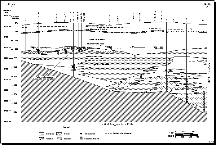
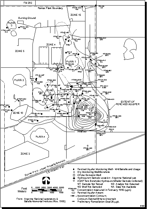
The perched aquifers are the uppermost saturated subsurface units capable of producing water in the Pantex Plant area. An expedited site characterization was conducted in 1994 and 1995 to characterize the location, shape or geometry, and depth of the perched aquifer; nature of recharge; and direction of groundwater flow. An expedited site characterization for the Pantex Plant Zone 12 groundwater was conducted to develop a working model of the perched aquifer. Specific objectives included characterizing the extent of the perched aquifer, nature of groundwater recharge, direction of groundwater flow, groundwater contamination, and identification of potential receptors.
The findings of the expedited site characterization are presented in the Draft RCRA Facility Investigation Report for Groundwater in Zone 12 at the DOE Pantex Plant (Argonne 1995a). Data collected during the expedited site characterization were used to predict contaminant movement and to evaluate cleanup options for perched groundwater; the results of this study are reported in Two-dimensional Groundwater Flow Model and Design Tool for Evaluation of Remedial Options for Perched Groundwater at Pantex Plant (Battelle 1996a). The primary area of concern in this modeling effort is the perched aquifer underlying Zones 11 and 12 and the area east and southeast of the plant boundary. Additional investigations have been conducted on private property south and southeast of Pantex Plant, under the Pantex Plant Groundwater Protection Project (MH 1996a).
The perched aquifer occurs as localized groundwater mounds that form beneath the playas from focused surface water recharge. Perched groundwater flow is unconfined (i.e., the water table forms the upper boundary of this aquifer). Perched groundwater accumulates in gravel and sand channel deposits at approximate depths of 64 to 88 meters (210 to 290 feet) below the ground surface. These water-bearing buried channel deposits are on top of a zone of fine-grained clays, clayey silts, and sands, as shown in Figure 4.6.1.23. The existence of the perched aquifer is dependent on the occurrence of the underlying fine-grained zone, which is of variable thickness, as shown in Figure 4.6.1.24. This fine-grained zone has a low vertical hydraulic conductivity that impedes the downward movement of infiltrating groundwater. Vertical hydraulic conductivity measurements for fine-grained sediments ranged from 4.62 x 10⁻⁶ to 6.92 x 10⁻⁹ centimeters per second (1.31 x 10⁻² to 1.96 x 10⁻⁵ feet per day) (Texas A&M University 1995a:7).
The perched zone has an irregular surface, and generally occurs 90 meters (300 feet) below land surface (Battelle 1996a:4). Where the fine-grained zone is present, perched groundwater collects in overlying sand and gravel deposits that form subsurface channel features and have a greater permeability than the fine-grained zone deposits. As a result, the buried channel deposits form a conduit for groundwater flow, and groundwater movement follows the course of the buried channel deposits. Variations or heterogeneities in the specific types, grain size distributions, and configurations of subsurface sediments result in preferential subsurface flow.
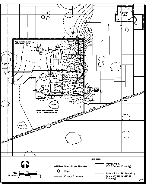
The changes in the direction and gradient of groundwater flow indicate that the perched aquifer exhibits radial flow from Playa 1. The perched aquifer is thickest beneath Playa 1. The only Pantex Plant playa that contains water throughout the year, Playa 1 is considered to be a source of focused recharge to the perched aquifer. Groundwater in the perched aquifer is considered to flow radially away from Playa 1. As shown in Figure 4.6.1.25, the groundwater flow direction in the perched aquifer may be locally to the west, northwest, southwest, and southeast due to radial flow and lithologic changes within the perched aquifer.
Figure 4.6.1.2-4.--Thickness of the Fine-Grained Zone, Pantex Plant.
Figure 4.6.1.2-5.--Water Table Contour Map of the Perched Aquifer, Pantex Plant.
The physical boundaries and groundwater flow conditions of the perched aquifer affect the extent and direction of suspected contaminant movement. The groundwater flow direction is primarily to the south and southeast under Zone 12, as shown in Figure 4.6.1.25. The perched aquifer is known to extend off the plant site to the east and southeast. Although data suggest that the perched aquifer may extend offsite to the north and to the west, hydraulic continuity is not completely understood due to lack of wells drilled in those areas. Recharge varies laterally between playa, interplaya, and drainage ditch environments.
Although the effectiveness of the fine-grained zone to act as a retardant to vertical groundwater movement is not fully understood, the presence of the fine-grained zone under the perched aquifer probably serves to significantly slow the downward migration of contamination to the Ogallala aquifer while allowing the horizontal spread of potential contamination to be limited to buried channel deposits in the perched aquifer. It is important to note that the perched aquifer is stratigraphically higher (closer to the surface) and not directly hydraulically connected with the underlying Ogallala aquifer. The depth to groundwater ranges from 64 to 88 meters (210 to 290 feet) below land surface in the perched aquifer and from 100 to 140 meters (340 to 460 feet) in the underlying Ogallala aquifer (Figure 4.6.1.23).
Table 4.6.1.2-1.--Estimated Groundwater Velocities and Travel Times in teh Perched Aquifer (.pdf)
The rate of groundwater movement, otherwise known as the groundwater velocity, can be calculated from estimates of the following physical hydrogeologic properties: hydraulic conductivity, defined as the estimation of the relative ease of groundwater movement; hydraulic gradient, or slope of the groundwater level; and the effective porosity, or the amount of void space through which groundwater movement can occur. The hydraulic properties have been measured from field and laboratory tests. These properties are used to calculate the rates of groundwater withdrawal and the potential spread of contamination. Aquifer performance tests were used to estimate groundwater velocities.
The results of these aquifer tests are highly variable and are dependent on the testing location, relative heterogeneities in the subsurface sediments from one location to another, duration of the test, variations in testing procedures, and the method of analysis. These variations in aquifer performance testing lead to differences in groundwater velocity estimates. Travel time estimates for groundwater movement in the perched aquifer are provided in Table 4.6.1.21. Three estimates are given. The first two estimates are based on initial onsite aquifer tests conducted in Zones 11 and 12, that assume hypothetical porosity values and a range of hydraulic gradients (Texas A&M University 1995:62, 64, 65). The third estimate is a realistic calculation based on long-duration onsite aquifer testing and field data collected during the Zone 12 Treatability Study in September and October of 1995 (Pantex 1995k).
It should be noted that Texas A&M Universitys conservative estimate of 1.8 meter (5.9 feet) per day produces a higher velocity than is expected to be generally true. The Texas A&M University report states that a value of 0.34 meter (1.1 feet) per day is more realistic. However, these flow velocity calculations do not include the travel time required for the surface water to percolate through the unsaturated zone or any retarding effects that physical, chemical, or biological processes may have on contaminant transport.
Aquifer performance test data from monitoring wells PTX061014 and PTX061017, obtained from the Zone 12 Treatability Study, were used to calculate groundwater flow velocities. Perched groundwater in the Zone 12 Treatability Study area moves to the east-southeast, at velocities ranging from 0.07 to 0.49 meter (0.23 to 1.6 foot) per day. Eliminating the outliers yielded a groundwater flow velocity of 0.18 meter (0.6 foot) per day. Similarly, velocities from each Treatability Study well to the pumping well, PTX061014 were calculated using the same hydraulic conductivity and water level measurements used in the Treatability Study calculations. Values ranged from 0.009 to 0.07 meter (0.03 to 0.24 foot) per day; eliminating outliers yielded a velocity of approximately 0.06 meter (0.2 foot) per day. From the velocity results, local velocities in the Treatability Study area and the velocities to the Pantex site boundary vary by a magnitude of three. These velocity differences may stem from changes in hydraulic conductivities or, more likely, from lithologic controls and the undulating perched aquifer surface (PC 1996a). Velocities ranging from 0.10 to 0.3 meter (0.32 to 0.96 foot) per day may most accurately characterize perched groundwater movement towards the Pantex Plant boundary in Zone 12 (Argonne 1995a:4-19).
The conclusion drawn from this data is that actual movement of contaminated groundwater offsite, once the contaminants percolate down to the perched aquifer, would require about 10 to 20 years, and may take as long as 50 or more years, to move a contaminant plume offsite using the most current test data described above. Recent investigations have indicated that contaminated groundwater in the perched aquifer has migrated to the eastern plant boundary and has migrated offsite. Because contaminated groundwater does migrate offsite in the perched aquifer, DOE conducted a program, known as the Pantex Plant Groundwater Protection Project, to identify and evaluate abandoned homestead wells and prevent potential pathways of contamination to the Ogallala aquifer. The Groundwater Protection Project, completed in September 1996, involved sealing 5 onsite and 2 offsite homestead wells; drilling 2 offsite wells completed in the perched aquifer and 1 offsite well completed in the Ogallala aquifer; and upgrading existing onsite wells.
If perched groundwater that has exceedances of contaminants of concern (COCs) is used for domestic or agricultural purposes, a potential for human exposure could result (Argonne 1995a:5-37). A groundwater treatability study is currently underway to evaluate perched groundwater treatability and potential reuse of treated water as a Pantex Plant water supply.
Ogallala AquiferThe Ogallala aquifer underlies the whole of the Texas Panhandle and the South Plains, as well as parts of New Mexico, Oklahoma, Colorado, Kansas, Nebraska, Wyoming, and South Dakota. It is the principal aquifer and the major source of water in the vicinity of Pantex Plant. Groundwater flow directions in the regional Ogallala aquifer in the vicinity of Pantex Plant trend from the southwest to northeast as shown in Figure 4.6.1.26. Groundwater movement is unconfined in the Ogallala aquifer. Depth to groundwater in the regional Ogallala aquifer ranges from 104 meters (340 feet) at the southern boundary of Pantex Plant to 140 meters (460 feet) at the northern boundary. The saturated thickness of the Ogallala Formation ranges from 15 meters (50 feet) to more than 120 meters (400 feet) and in some areas is capable of producing yields in excess of 4,000 liters (1,000 gallons) per minute (DOE 1991b:13). A summary of hydraulic parameters measured onsite is presented in volume II, appendix C.
Regional hydraulic conductivity in the Ogallala aquifer ranges from 0.9 to 79 meters (3 to 260 feet) per day. Estimates of annual recharge rates to the Ogallala aquifer vary from 0.02 to 4.1 centimeters (0.01 to 1.6 inches) per year, based on earlier studies that investigated slow regional infiltration of precipitation and recent studies that explored recharge of water through playa lakes and leakage from the Dockum Group aquifer into the Ogallala aquifer (Texas A&M University 1988:16, 25; TWD 1993:6). While these studies support the concept of Dockum recharge to the Ogallala in some areas of the Panhandle, the hydraulic characteristics of the Dockum Group aquifer have not been fully investigated in the vicinity of Pantex Plant. In 1990, the recoverable volume of water in storage and available for use in the Ogallala aquifer was estimated at approximately 5.15 x 10¹⁴ liters (1.36 x 10¹⁴ gallons) in the High Plains aquifer system (TWD 1993).
Dockum GroupThe Dockum Group underlies the Ogallala aquifer and consists of shales, clayey siltstones, and sandstones. Beneath the Dockum Group are Permian salt beds and salt dissolution residues, as discussed in section 4.5, Geology and Soils. Aquifer properties of the Dockum Group near Pantex Plant are highly variable, but generally have low permeability, low average yields of 400 liters (105 gallons) per minute, and poor water quality (high total dissolved solids) relative to the overlying Ogallala aquifer. Near Pantex Plant, however, water quality in the Dockum Group aquifer is relatively good, possibly due to intermixing of waters from the overlying Ogallala aquifer (Pantex 1996:4.3). Several wells near Pantex Plant lie in what is considered the Dockum aquifer and are used for domestic and livestock purposes. However, since the overlying Ogallala aquifer is the primary source of groundwater for the area, pumping in the Ogallala is expected to cause upward groundwater movement from the Dockum Group. Furthermore, leakage from the Dockum Group upward into the Ogallala aquifer has been reported as a potential source of recharge to the Ogallala aquifer (TWD 1993:6).
Figure 4.6.1.2-6.--Contour Map of the Ogallala Aquifer, Pantex Plant.
Groundwater Quality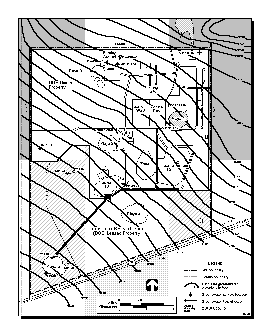
Assessment of the existing groundwater quality is necessary to establish a baseline, in order to assess the potential for the Proposed Action to impact groundwater resources. It is important to note that this section only describes a water quality "snapshot" of the existing conditions (baseline) of contaminants that were released in the past and have reached the water table. It does not describe the quality of surface water discharge that is currently being released at the ground surface (see section 4.6.1.1, and volume II, appendix C). Potential sources of historical contamination include the solid waste management unit (SWMU)solid waste management units (SWMUs) that were identified during an RFI in January 1989. Discussion of these SWMUs is presented in section 4.5.1.3.
Under the existing DOE environmental monitoring program, groundwater monitoring of the perched and Ogallala aquifers has been conducted at Pantex Plant for the past 20 years. Before the initiation of the RFI activities, the scope of perched groundwater quality sampling was limited and consisted of sampling five wells on a monthly basis. However, due to the absence of appropriate quality control methods, analytical data obtained from these wells before 1990 are generally considered unreliable (USCOE 1995a:4). After instituting appropriate quality control procedures in 1990, monitoring wells in the perched and Ogallala aquifers continued to be sampled. After the RFI work began, groundwater monitoring wells installed by U.S. Army Corps of Engineers (COE)COE in conjunction with the RCRA site investigations were compiled into a network of wells that are used to routinely monitor perched groundwater quality for a wide range of constituents (volume II, appendix C). Available groundwater quality data that have been collected from 1990 to 1994 and reported in either the Annual Site Environmental Reports (published annually by DOE) or the COE investigation have been compiled in volume II, appendix C.
Pantex Plant perched and Ogallala monitoring wells are sampled and analyzed for radionuclides, metals, explosives, PCBs, pesticides, herbicides, volatile organic compound (VOC)volatile organics, and other selected parameters, as discussed in volume II, appendix C. Results of five years of groundwater quality data, presented in volume II, appendix C, indicate that the perched aquifer is contaminated with HE, volatile organics, and metals. Based on the number of exceedances and magnitude of contamination, the most significant contaminants are RDX, 1,3,5-trinitrobenzene, trichloroethylene, and chromium. Overall, results for 1995 were similar to those for 1994 (Pantex 1996c:82).
Suspected high explosive(s) (HE)HE COCs include RDX, 1,3,5-trinitrobenzene, 2,4,6-trinitrotoluene, and HMX. An additional HE, DNT, was detected in 13 out of 211 samples in 1995 (Pantex 1996c:85). In terms of areal extent and magnitude, RDX and 1,3,5-trinitrobenzene are the most significant HE compounds. Problem wells, in terms of the highest concentrations of multiple HE compounds, are perched monitoring wells PTX061004 and PTX061005 (USCOE 1995a:51). The most extensive HE contaminant plumes (for all suspected HE COCs) have developed just east of Zone 12 beneath the approximate location of Landfill 3. Concentrations of RDX in perched monitoring wells PTX061004 and PTX061005 range from over 1,000 micrograms per liter to almost 5,000 micrograms per liter, which significantly exceed Pantex Plant RRS of 26 micrograms per liter. Contamination from RDX extends beyond the eastern boundary of Pantex Plant (Figure 4.6.1.27).
The migration of RDX is to the southeast from the east side of Zone 12 and appears to occur within the buried channel deposits of the perched aquifer (DOE 1995f:5-20). RDX contamination has been determined to extend offsite. Concentrations of 1,3,5-trinitrobenzene in these perched monitoring wells have ranged from over 300 micrograms per liter to over 2,200 micrograms per liter, which significantly exceed the standard of 5.11 micrograms per liter. Trinitrotoluene and trinitrobenzene were only found in groundwater at the base of the perched aquifer. In contrast, RDX and HMX generally decreased in concentration from the top to the bottom of the aquifer near the source and reversed this trend away from the source.
Figure 4.6.1.2-7.--RDX Concentrations in the Perched Aquifer, Pantex Plant.
The absence of trinitrotoluene in the upper part of the perched aquifer may indicate a decline in historical usage and disposal of trinitrotoluene over time, and the subsequent release of trinitrotoluene from the unsaturated zone, since discharge of HE-contaminated water ceased in 1989 (DOE 1995f:5-20). Evidence of natural attenuation and degradation of HE compounds, such as trinitrotoluene, has been documented during treatability studies. In order to define the stratification of contaminants within the perched aquifer, due to different densities of the contaminants, it is necessary to sample at discrete intervals and depths.
Volatile organic COCs include trichloroethylene, 1,2-dichloroethane, methylene chloride, tetrachloroethene, and benzene. Based on the number of exceedances and magnitude of contamination, trichloroethylene is the most significant volatile organic contaminant. However, much of the trichloroethylene contamination occurred at levels that often barely exceeded the RRS decision criteria of 5 micrograms per liter. Additional information is presented in volume II, appendix C.
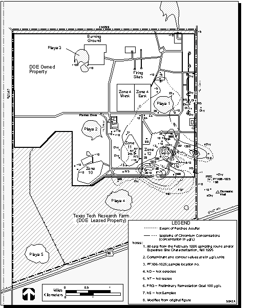
Metal COCs include chromium, hexavalent chromium, copper, nickel, iron, lead, and manganese. Chromium and hexavalent chromium are the most widespread and have the highest concentrations of the metals detected in perched groundwater. In several perched aquifer wells, chromium concentrations exceeded the decision criteria standard of 100 micrograms per liter (Texas Natural Resource Conservation Commission (TNRCC)TNRCC Primary Maximum Contaminant Levels for Drinking Water and Pantex Plant RRS). These exceedances ranged from barely over the standard to over 9,000 micrograms per liter in perched monitoring well PTX061010.
An example of how concentrations of chromium have changed over time is shown in a graphical plot of time versus chromium concentration for one well, OWWR20, in Figure 4.6.1.28. The areal extent of chromium concentrations in the perched aquifer is shown in Figure 4.6.1.29. Chromium concentrations for the perched aquifer are shown as isopleths (lines showing levels of equal concentration). One area of chromium contamination that requires further delineation occurs along the eastern plant boundary, in the vicinity of offsite borehole PTX06-1025, where filtered and unfiltered perched aquifer samples were collected and analyzed for chromium. The concentration of chromium measured in the filtered sample was less than the detection limit of 10 micrograms per liter, whereas the concentration of chromium measured in the unfiltered sample was 198 micrograms per liter (Figure 4.6.1.29) (MH 1995c:18).
The historical sources of chromium processing were located in the vicinity of where the highest chromium concentrations occur. For example, chromium was processed in Zone 12 at an electroplating facility (tool and die shop) in the form of a chrome plating solution between 1976 and 1986. During this time, electroplating wastewater effluent would be discharged to a below-grade sump that would occasionally overflow. Other historical sources of chromium at Pantex Plant include chromate compounds used in the former cooling tower operations (from 1950 to 1964); residues of chromic acid in old sewage treatment plant sludge beds, the construction debris landfills, waste products at the Burning Ground, past effluent disposal at Playa 1, and in containers and materials dumped in Landfills 1, 5, and 13 (Argonne 1995:3-29 to 3-49). It is highly likely that these earlier releases contributed to the high concentrations of chromium that occur in the perched monitoring wells today.
Figure 4.6.1.2-8.--Chromium Concentrations at OW-WR-20 from January 1992 through May 1995.
Figure 4.6.1.2-9.--Chromium Concentrations in the Perched Aquifer, Pantex Plant.
Investigations regarding the sources, concentrations, and removal of chromium at Pantex Plant are ongoing. These chromium investigations include determining whether elevated chromium levels could have been caused by the amount of chemicals used for conditioning cooling water during the towers operational period (1950 to 1964), chromium anion exchange and column studies to determine whether ion exchange resins would be an effective treatment technology, and geochemical modeling to predict the fate and transport of chromium species in groundwater. Additional data for metals that exceed the decision criteria are provided in volume II, appendix C.
Radionuclides are also measured in groundwater quality samples; however, the levels (or activities) of radionuclides are less than the decision criteria specified in the DOE derived concentration guides for ingested water for radiation protection (DOE Order 5400.5). As a result, radionuclides are not considered to be suspected COCs in perched groundwater at Pantex Plant.
Groundwater quality in the perched aquifer has been affected by the activities that have occurred over the past 40 years at Pantex Plant. Since the perched aquifer is the shallowest water-bearing zone in the area, it is the first groundwater unit affected by migration of contaminants that were released from past industrial operations. These operations generated HE materials, organic solvents, and metals in liquid and solid wastes. The direction and rates of contaminant movement in the perched aquifer are controlled by the location of buried channel deposits and the underlying fine-grained zone, direction and rate of groundwater movement, and source areas of historical contamination. Contaminants originating in Zone 12 have reached the perched aquifer through historical vertical infiltration from ditches, landfills, and other past localized source areas in the interplaya area (DOE 1995f:5-16).
Available information on the historical sources of contamination and the waste disposal history has revealed that the inorganic wastes were discarded primarily in acid pits in the southern part of Zone 12. Explosive wastes were disposed of in the ditches in the eastern part of Zone 12 and at other locations cited in Table 4.6.1.22 (DOE 1994nn:3-33, 3-38). Argonne National Laboratory has noted that HE contaminant distributions suggest that a significant or dominant proportion of recharge to the perched aquifer in the Zone 12 area has occurred between the playas. This may be a result of vertical infiltration from unlined surface ditches used to carry liquid wastes onsite. HE was found at a depth of 14 meters (45 feet) in unsaturated zone samples collected from a ditch leading from Zone 12 to Playa 1. At this location RDX and HMX were found to a depth of 6 meters (20 feet), and 1,3,5-trinitrobenzene was found between 6 and 14 meters (20 and 45 feet). No trinitrotoluene was detected in the unsaturated zone. Because of its solubility and biodegradable characteristics, it is believed to have been leached or degraded since the practice of discharging effluent that may have contained high explosive(s) (HE)HE was discontinued (DOE 1995f:5-20).
Downward migration of perched groundwater could potentially affect the groundwater quality of the underlying Ogallala aquifer. The low vertical permeability of the fine-grained zone could potentially be compromised by abandoned homestead wells that could provide contaminant pathways through the fine-grained zone to the Ogallala aquifer. Low levels of HE contamination have been detected by TNRCC at less than one part per billion of RDX in a domestic Ogallala well located on private property southeast of Pantex Plant. As a precautionary measure, DOE has identified and evaluated abandoned homestead wells in order to prevent potential pathways of contamination into the Ogallala aquifer. Efforts to mitigate further possible contamination have been completed. The well in question was properly plugged and sealed under the supervision of TNRCC and a replacement Ogallala well was drilled and completed in order to prevent further potential cross-contamination of the Ogallala aquifer.
Pantex Plants Groundwater Protection Project was conducted to ensure the integrity of offsite groundwater quality (MH 1996a). The scope of this project included performing three distinct tasks to protect groundwater beneath Pantex Plant from cross contamination between the perched aquifer and the Ogallala aquifer. The activities associated with these tasks were completed in September 1996 at 23 different well locations. These tasks included upgrading existing monitoring wells, sealing offsite homestead wells, and installing new wells offsite.
Monitoring well upgrade activities included installation of barrier posts, installation of protective metal casings, construction or repair of concrete pads, painting exposed steel structures, and resurveying well locations. Well sealing and plugging was necessary for existing vintage Ogallala production wells that could potentially result in cross-contamination between the perched and Ogallala aquifers. Under this task, five wells at Pantex Plant and two private production wells on land adjacent to the plant were sealed. The third task involved installing three monitoring wells, two new perched wells and one new Ogallala well, on private property adjacent to and east of the plant. The Ogallala well has also been designated for use as a domestic production well.
Available routine groundwater quality analytical results from 1990 through 1994 are summarized in volume II, appendix C for groundwater samples collected from the regional Ogallala aquifer. Levels of copper in one Pantex Plant well, iron in four wells, and lead in three wells measured in the Ogallala aquifer have either met or been higher than Pantex Plant RRS and drinking water maximum contaminant levels on several occasions, as shown in volume II, appendix C. However, no exceedances of high explosive(s) (HE)HE, organic compounds, or radionuclides were measured in Ogallala wells onsite. There was no evidence of contaminated groundwater from the overlying perched zone reaching the Ogallala aquifer in samples collected from Ogallala aquifer monitoring wells (Pantex 1996c:87). Elevated concentrations of copper, lead, iron, and zinc may be related to other factors, such as well construction and piping, rather than the spread of contaminants in groundwater.
Additional InvestigationsThe rate of potential contaminant transport under and beyond Pantex Plant boundaries is dependent upon the rate of infiltrating surface water recharge; the concentrations of contaminants; the solubility of these contaminants; vertical and horizontal groundwater movement; the mixture of contaminants present; soil and sediment characteristics; and physical, chemical, and biological processes, such as adsorption and biodegradation. Investigations to characterize the potential for contaminant migration are ongoing.
The University Consortium (University of Texas Austin, Texas A&M University, and TTU Water Resources Information Center) is conducting several investigations to support, supplement, and enhance the activities of the Pantex Plant ER Program. A perched aquifer tracer test at the Pantex Plant Zone 12 treatability site is being conducted to evaluate the efficiency of groundwater recirculation for remediation, to determine potential retardation effects on HEs from the injection of treated wastewater, and to predict long-term performance of the remediation system. Soil vapor extraction modeling and a tracer test in unsaturated sediments above the perched aquifer is being conducted to predict the efficiency of soil vapor extraction. Several bioremediation investigations are being conducted, including an evaluation of the effectiveness of selected microorganisms for HE degradation.
Ecological risk assessments are being conducted to determine potential contaminant pathways for biota. Ongoing chromium investigations include determining whether elevated chromium levels could have resulted from chemicals used for conditioning cooling water during the towers 14-year operational period, determining potential soil and groundwater geochemical reactions through chromium anion exchange and column studies, determining whether ion exchange resins would be an effective treatment technology, and geochemical modeling to predict the fate and transport of chromium species in groundwater, as previously discussed.
Groundwater UsesThe Ogallala aquifer is a primary source of groundwater in the High Plains and is used for irrigation, industrial process water, and the municipal potable water supply at and in the vicinity of Pantex Plant. This aquifer has not been classified by EPA. The City of Amarillo draws its raw water from the Ogallala aquifer and Lake Meredith. During the 1995 water year (from October 1994 through September 1995), approximately 23.6 billion liters (6.2 billion gallons) were pumped from the Carson County wellfield, located just north and northeast of Pantex Plant (Table 4.6.1.23). This wellfield consists of 37 wells and 2 standby wells completed in the Ogallala aquifer (Pantex 1996:4.8).
The withdrawal of water from regional pumping in the Ogallala aquifer continues to exceed recharge, causing groundwater levels in the Ogallala aquifer to decline in the Pantex Plant area at a rate of approximately 0.6 to 2 meters (2 to 5 feet) per year (DOE 1995k:4-293). Water levels have declined approximately 30 meters (100 feet) since the Carson County production wells went into use (DOE 1990b:16). From 1980 to 1990, the Carson County Wellfield experienced up to 20 meters (60 feet) of water level decline, which may have contributed to a depression in the groundwater surface northeast of Pantex Plant (TWD 1993:11).
Five Ogallala production wells (1517, 156, 1520, 1516, and 1526) in the northeast corner of Pantex Plant serve the plants industrial and potable water needs. An additional water supply well (1532) has been drilled to the east of 1526 but has not been completed (Pantex 1996:4.8). In 1995, Pantex Plant reported a total production level of 869 million liters (230 million gallons) of water from onsite production wells; 618 million liters (163 million gallons) were used by Pantex Plant for industrial or domestic purposes, and 251 million liters (66 million gallons) were used by Texas Tech University (TTU)TTU for irrigation or domestic consumption (Table 4.6.1.23). The 1995 plant consumption was a reduction from the 1994 consumption, which was 707 million liters (186 million gallons) (Pantex 1996c:9, 11).
The Ogallala aquifer is a critical resource for the Texas Panhandle, and its capacity, while quite large, is being drawn down. Typically, Carson County agriculture relies heavily upon irrigation to achieve economic production rates. The current operations of Pantex Plant have not impacted the regions agriculture. Water use at Pantex Plant accounted for only 0.7 percent of the total estimated water use in Carson County for 1995 (Table 4.3.1.23). In 1995, Carson County irrigated 25,751 hectares (63,629 acres), using 101 billion liters (26.6 billion gallons) per year. Thus irrigation use accounted for 80.5 percent of the total water consumption in 1995 for Carson County. Production and use of groundwater in the vicinity of Pantex Plant are affected by the growing season, climatic conditions, and demand for irrigation water for crop production (Pantex 1996:4.8).
In addition to water use from the Ogallala aquifer, at least two private wells tap the perched aquifer(s) within 0.8 kilometers (0.5 miles) of Pantex Plant Site. These two private wells located north and west of Pantex Plant are believed to be cross gradient (i.e., groundwater moves in a different direction) from the contaminated groundwater in Zone 12, which flows to the southeast. The approximate locations of all private and municipal supply wells are shown in Figure 4.6.1.21. Investigations to determine the potential for contaminant migration are ongoing.
Groundwater Rights and PermitsTexas enacted a groundwater law in 1949 that authorized the formation of local districts having the power to make and enforce regulations governing groundwater withdrawal. By virtue of this law, Texas has given the power of regulation to local groups, thus placing the responsibility for regulation at the lowest possible governmental level capable of performing the desired functions (USGS 1976). The Texas Water Code Section 52.024 grants the Texas Water Commission the authority to designate Underground Water Management Areas in the State of Texas in the form of a rule to protect groundwater resources. Groundwater resources in the area governed by the Panhandle Groundwater Conservation District, including the Pantex Plant area, have not been designated as Class I or a critical area. Pantex Plant is located in Panhandle Groundwater Conservation District No. 3, which has the authority to require permits and limit the quantity of water pumped.
Historically, the Panhandle Groundwater Conservation District does not limit the quantity of water pumped (DOE 1995k:4-297). However, for new wells drilled after July 19, 1995 that produce annually more than 1.3 million liters (350,000 gallons) of water per acre owned, on a section by section basis, landowners will be required to obtain a High Production Permit from the Panhandle Groundwater Conservation District (PGCD 1995:25). Texas Natural Resource Conservation Commission (TNRCC)TNRCC and the Texas Water Development Board are the two State agencies primarily involved with groundwater fact finding, data gathering, and analysis.
4.6.2 Impacts of Proposed Action
4.6.2.1 Impacts of the Continued Operations
Weapons-Related ActivitiesSurface Water. Operations at Pantex Plant have not substantially impacted delineated flood-prone areas in the past, and continued operations are not expected to cause impacts in the future. The proposed areas of activity are outside of 100-year, 500-year, and Standard Project Flood boundaries. Pantex Plant is in compliance with current wastewater and stormwater discharge permits. Wastewater discharge associated with operations on 2,000, 1,000, or 500 weapons per year is expected to continue. These discharges are not expected to impact surface water quality because, while the projected annual wastewater discharges represent a 36 percent increase over fiscal year (FY) 1994 usage for the 2,000 weapons level, the levels of contaminants in the wastewater are held by current regulations to levels that do not impact the environment. This increase is only 48 percent of the sites remaining wastewater treatment capacity. The 500 weapons level would represent an 8 percent decrease in wastewater production (Table 4.6.2.11). Texas Natural Resource Conservation Commission (TNRCC)
Groundwater. Section 4.6.1.2 provided an of the existing (baseline) hydrogeologic and water quality conditions that exist at Pantex Plant. The existing groundwater contamination that has been detected in the perched aquifer is the result of over 40 years of past activities and waste generation at Pantex Plant. Over this time period, contaminants that were previously released at the ground surface had to percolate through unsaturated soil and sediments to the perched aquifer. Groundwater contamination of the perched aquifer has been detected offsite to the east and southeast. As stated in section 4.6.1.2, if contaminated groundwater from the Zone 12 perched aquifer is used in the future for domestic or agricultural purposes, a potential exposure pathway (i.e., ingestion, bathing, or irrigation) could result (Argonne 1995a:5-37). Pantex Plants Groundwater Protection Project was implemented to ensure the integrity of offsite water quality by sealing homestead wells, upgrading some monitoring wells, and drilling additional monitoring wells (MH 1996a).
Assessment of the impacts of the continued operations to groundwater resources at the plant involves the evaluation of the potential for additional groundwater contamination from wastewater discharge activities, and the evaluation impacts from future groundwater use projections; these areas of concern are considered in this section. The potential for additional impacts to groundwater quality from wastewater discharge activities is minimal due to the contaminant removal efficiency of the industrial and sanitary wastewater treatment process currently being used. Although the projected annual wastewater discharges represent a 36 percent increase over FY 1994 usage, the quantity of wastewater discharge is less than the total wastewater discharge capacity. The quality of the wastewater discharge is such that it will not degrade the quality of the groundwater in either the perched or Ogallala aquifers, because the wastewater discharge is regulated through the EPA Region 6 NPDES Permit and TNRCC Wastewater Discharge Permit. Pantex Plant has worked very closely with EPA Region 6 and the TNRCC to produce wastewater discharge permits (EPA NPDES Permit No. TX-0107107 and TNRCC Wastewater Discharge Permit No. 02296) that provide stringent wastewater discharge requirements that are protective of human health and the environment (section 4.6.1.1).
The hydrology and recharge of the perched aquifer is very complex and the effects upon the vadose zone from continual discharge of water into the existing playas and drainage ditches does not necessarily result in contaminated groundwater being driven into the Ogallala aquifer. ER investigations, conducted at or before the time of publication, have indicated that the extent of offsite contamination detected in the perched groundwater has been limited to within one-half mile southeast of the main Pantex Plant site boundary. The ER Program is currently conducting corrective actions to protect human health and the environment.
Groundwater contamination has occurred in the perched aquifer as a result of past site-related activities. For the past seven years, the Pantex Plant ER Program has assessed inactive sites, conducted investigations to determine the nature and extent of contamination, and implemented remediation strategies to eliminate any present or future threat to human health and the environment. These activities to investigate historical sources of contamination and correct the extent of problems created by past practices will continue in the future through the environmental restoration (ER)ER program. Wastewater discharge would be released to the playas and natural drainage channels in accordance with the EPA NPDES and TNRCC Wastewater Discharge Permit requirements. There are no direct discharges to groundwater (DOE 1995k:4-327).
No additional impacts to groundwater quality conditions from routine continued operations are anticipated since all wastewater discharge must comply with Texas Natural Resource Conservation Commission (TNRCC)TNRCC and EPA wastewater discharge permit limits. Although groundwater in the perched aquifer is contaminated as a result of past site-related activities, the environmental restoration (ER)ER program is currently conducting field activities to characterize the nature and extent of contamination. Groundwater monitoring for the perched and Ogallala aquifers will continue, and groundwater treatability options are currently being explored. The impacts of discharging treated wastewater, within permit limits, to the playas and ultimately to the groundwater system are negligible when compared to baseline conditions and in consideration of the ongoing ER activities at Pantex Plant.
Groundwater used for continued operations would be withdrawn from the onsite Pantex Plant production wells, completed in the Ogallala aquifer, at the projected withdrawal rates listed in Table 4.6.2.11. The 2,000 weapons level would represent a 20 percent increase over FY 1994 withdrawals. This increase represents 16 percent of the remaining water supply capacity at the plant.
Pit Storage ActivitiesUnder the Proposed Action, the maximum number of pits that could be stored at Pantex Plant would be increased from 12,000 to 20,000. Storage activities do not pose additional impacts to water quality or availability beyond those described for the continued operations above.
Environmental Restoration ActivitiesUnder the Environmental Protection program, routine surface water and groundwater monitoring is conducted at Pantex Plant. Since a potential exists for the migration of contamination from the soils into groundwater resources, impacts to water resources would be expected to decrease as a result of ER activities.
Groundwater characterization efforts are ongoing at Pantex Plant. Current activities include determining the extent of groundwater contamination; determining the sources of contamination, contaminant mobility and transport properties; and technical support and information transfer for site characterization studies from the University Consortium of the University of Texas at Austin, Texas A&M University, and Water Resources Center at Texas Tech University (TTU)TTU (section 4.6.1.2).
DOE completed a Groundwater Protection Project to clean up the groundwater to residential drinking water standards beyond the facility boundary. The Groundwater Protection Project included efforts to identify, evaluate, and seal homestead wells which could provide contaminant pathways of contamination to the Ogallala aquifer, as previously discussed. Additional remediation activities that are currently underway at Pantex Plant include contaminated soil removal within the vicinity of onsite ditches and playas and a groundwater treatability study to determine the most effective method(s) to clean up perched groundwater (Stroller 1996:1-1).
The groundwater treatability system, located in Zone 12, combines a dual groundwater pump-and-treat system with a soil vapor extraction system to remediate and abate the migration of onsite high explosive(s) (HE)HE, volatile organic compounds, and metal contaminants beneath Zone 12 and its immediate vicinity. This system is designed to treat contaminants in both the unsaturated soils and groundwater of the perched aquifer (MH 1995a:1). Granulated activated carbon adsorption would be expected to remove most of the COCs. A resin-based treatment to remove chromium is also included in the process. Groundwater treatment involves pumping contaminated groundwater out of the perched aquifer, treating the contaminated groundwater in a carbon-filtration system to remove HE contamination, and then draining it back into the perched aquifer. The only direct discharge is the draining of treated groundwater to the perched aquifer. This ER treatability study has been approved by the TNRCC.
When the treated groundwater is reintroduced into the perched aquifer, it flushes and displaces the existing contaminated groundwater, moving it toward the treatment system wells for cleanup. Groundwater moves through void spaces in between unconsolidated sand, silts, and gravels, and is treated at an approximate rate of 160,000 liters (42,000 gallons) per day. The treatability system began operating just eight months after the initial boundary contamination was discovered. The treated water now meets drinking water standards, as confirmed by co-sampling conducted by the TNRCC (Pantex 1996c:55). Evidence of natural attenuation and degradation of HE compounds including trinitrotoluene have been documented during the treatability studies (PC 1996n).
4.6.2.2 Impacts of New Facility Construction and Upgrades
Six new facilities have been proposed for Pantex Plant. The projected construction phase for these facilities spans from 19962001. All of these facilities would be located in Zones 11 and 12. Since no 100-year, 500-year, or Standard Project Flood boundaries have been delineated in Zones Zone 1111 and Zone 1212, there would be no impacts to floodplains. Surface water use is not an issue because all water required for construction or operation would be supplied from groundwater. The treated effluent from the process wastewater treatment would be discharged to the playas and monitored to comply with EPA NPDES Permit and TNRCC Wastewater Discharge Permit requirements. Environmental impacts to water resources from the proposed facility construction and upgrades for each of the six facilities are summarized in Table 4.6.2.21.
All water required for construction or operation would be supplied from groundwater withdrawn from Pantex Plant wells. Projected water usage is compared to current water usage on a site-wide and facility-specific basis. The upper bounding conditions (i.e., 2,000 weapons level) would result in a projected annual groundwater withdrawal of 1, million liters (267 million gallons), or an increase of 64 percent over FY 1995 industrial and domestic water use. Under the 2,000 weapons scenario, Pantex Plant groundwater withdrawals would only account for 0.8 percent of the total estimated annual groundwater withdrawals in Carson County.
Hazardous Waste Treatment and Processing Facility (HWTPF)Hazardous Waste Treatment Plant Facility
Domestic wastewater from the Wastewater Treatment Facility (HWTPF) would be collected in the Pantex Plant sanitary sewer system and treated in the WWTF prior to discharge into Playa 1. A treatment facility, such as the HWTPF, that is constructed and maintained properly would prevent further injury to natural resources. Industrial wastewater generated by operations associated with waste treatment would be disposed of in accordance with applicable Federal, State, and local environmental laws and regulations.
Particular industrial disposal options are discussed in section 4.13.1. An additional 0.227 million liters (0.06 million gallons) of domestic wastewater and 2.9 million liters (0.77 million gallons) of industrial wastewater would be generated each year, based on the difference between current and projected generation for the HWTPF (Table 4.6.2.21). However, this additional output is less than a 0.7-percent increase of the 477 million liters (126 million gallons) total site-wide FY 1994 volume of treated wastewater, less than 0.5 percent of the 649 million liters (171 million gallons) projected wastewater volume for the 2,000 weapon level, and less than 1.8 percent of the total remaining wastewater system capacity of 181 million liters (48 million gallons). The increased usage of 3.6 million liters (0.96 million gallons) per year of water that would be required for the HWTPF would be less than 0.4 percent of the reported groundwater usage in FY 1994 (836 million liters [221 million gallons]) and just over 0.3 percent of the remaining total system capacity.
Pit Reuse FacilityPit Reuse FacilityDischarge of domestic water from the Pit Reuse Facility would be collected in the Pantex Plant sanitary sewer system and treated in the WWTF. The projected annual demands are anticipated to be 0.32 million liters (0.084 million gallons) per year for water and wastewater (Table 4.6.2.21). Pit reuse is not a current activity at Pantex Plant so there are no existing water consumption and wastewater generation figures. Treated wastewater generated from the Pit Reuse Facility would be less than a 0.07 percent increase over the plants FY 1994 wastewater discharges. The additional water demands of the pit reuse facility represent less than a 0.04 percent increase over the total amount of water used in FY 1994 at Pantex Plant. Therefore no increase in impacts is expected.
Gas Analysis Laboratory (GAL)Water consumption and wastewater generation are expected to remain the same at 0.912 million liters (0.241 million gallons) per year (Table 4.6.2.21). Thus there would be no change in impacts to water resources from this facility.
Materials Compatibility Assurance Facility (MCAF)
Proposed water consumption and wastewater generation are expected to remain the same as current conditions of 8,640 million liters (2,280 million gallons) of water usage and 7.62 million liters (2.013 million gallons) of wastewater generated (Table 4.6.2.21). No change in impacts is anticipated.
Nondestructive Evaluation Facility
The total annual volume of water consumed and treated wastewater generated is not expected to change from the current conditions of 9.1 million liters (2.4 million gallons) per year of water usage and 8.02 million liters (2.1 million gallons) of wastewater generated (Table 4.6.2.21). As a result, no change in impacts to water resources would be expected.
Metrology and Health Physics Calibration and Acceptance Facility
Wastewater generated at this new facility is expected to remain at 9.30 million liters (2.45 million gallons) per year. No additional inputs for wastewater generation are expected as a result of construction. Water usage is expected to remain at 10.5 million liters (2.78 million gallons) per year.
4.6.2.3 Summary of Impacts
This is the Floodplain Statement of Findings as required by 10 CFR 1022. Continued operations and increasing pit storage would not affect the delineated floodplains.
An analysis of wastewater discharged to the playas indicates that the volume of the release would be within the Texas Natural Resource Conservation Commission (TNRCC)TNRCC permitted limit of 2.5 million liters (0.65 million gallons) per day (PC 1995d). Impacts to groundwater quality from normal operations during the period covered by this EIS are expected to be negligible because only wastewater that complies with EPA and TNRCC permit limits would be released to ditches and playas.
Site-wide groundwater use at Pantex Plant is projected as approximately 1, million liters (267 million gallons) per year for the 2,000 weapons scenario. The plant pumped 618 million liters (163 million gallons) for industrial or domestic uses in 1995. The 2,000 weapons scenario would result in an increase of approximately 393 million liters (104 million gallons) per year above the 1995 plant water use. Therefore, under the 2,000 weapons scenario, total Plant water use would increase by approximately 64 percent. In 1995, Pantex Plants actual water usage was approximately 33 percent of the plants total groundwater production capacity. Under the 2,000 weapons scenario, the projected water usage is 53 percent of the plants total capacity of 1,890 million liters (500 million gallons), representing an increase of 20 percent of the total production capacity for industrial and domestic water uses. Pantex Plant production wells withdraw a relatively small amount of groundwater from the Ogallala aquifer, currently only about 0.7 percent of the total amount of groundwater used in Carson County (section 4.6.1.2). Typically, Carson County agriculture relies heavily upon irrigation to achieve economic production rates. Irrigation use currently accounts for 80.5 percent of the total water consumption in 1995 for Carson County.
4.6.3 Impacts of No Action Alternative
Under the No Action Alternative, DOE would continue current and planned activities at Pantex Plant as discussed in section 3.1.2. The potential impacts that could result from continued operations, environmental restoration (ER)ER, and waste management are similar to or less than those identified for the Proposed Action. No additional impacts to water resources are anticipated beyond the effects of existing and planned activities.
4.6.4 Pit Storage Relocation Alternative
The Pit Storage Relocation Alternative involves continued operation and maintenance activities at Pantex Plant and transportation and interim storage of pits from Pantex Plant to other DOE or Department of Defense sites. The impacts to water resources from activities other than storage that would continue at Pantex Plant are the same as those discussed for the Proposed Action. While the pits are stored at Pantex Plant, they are placed in secured buildings on concrete slabs that do not permit contact with soils, surface water, or groundwater. The transportation of pits that would be relocated (20,000 or 8,000) would not affect the water resources at Pantex Plant.
4.6.5 Cumulative Impacts
The cumulative impacts presented here include impacts of the continued operations at Pantex Plant combined with impacts associated with activities described in the WM PEIS, SSM PEIS, and S&D PEIS. Since the Pantex Plant EIS Proposed Action and the SSM PEIS No Action Alternative represent a continuum of operations, the impacts associated with any new mission or facility that could be implemented at Pantex Plant are discussed in the context of that continuum. The impacts from the WM PEIS program are combined with those of the Pantex Plant EIS Proposed Action. The impacts from the S&D PEIS are combined with those of the SSM PEIS No Action Alternative. A detailed discussion of this methodology is presented in section 4.2.
4.6.5.1 Impacts of Alternatives in the Waste Management
Programmatic Environmental Impact StatementIf the facilities described in the WM PEIS were located at Pantex Plant, no groundwater quality impacts are expected, i.e., there would be no exceedances of water quality standards or permitted levels. Section 4.3.5.1 discusses water use and wastewater generation impacts.
4.6.5.2 Impacts of Alternatives in the Stockpile Stewardship and
Management Programmatic Environmental Impact StatementThe SSM PEIS includes three alternatives that apply to Pantex Plant: No Action, Downsize Existing Capability, and Relocate Capability. Under the No Action Alternative, no downsizing or modification of facilities would occur. Due to the reduced workload expected in the future, impacts to water resources from operations would be expected to be less than current impacts. Water requirements would be met without increased aquifer drawdowns. Under the downsizing alternative, the groundwater withdrawals would reduce by 16 percent compared to those under the No Action Alternative. Under the relocation alternative, all water use for assembly and disassembly operations and high explosive(s) (HE)HE fabrication would cease.
4.6.5.3 Impacts of Alternatives in the Storage and Disposition of Weapons-Usable Fissile Materials Programmatic Environmental Impact Statement
The S&D PEIS is considering Pantex Plant for long-term storage of inventories of nonsurplus weapons-usable plutonium and highly enriched uranium (HEU), storage of inventories of surplus weapons-usable plutonium and HEU pending disposition, and disposition of surplus weapons-usable plutonium. For storage, the strategy for long-term storage of weapons-usable plutonium and HEU, as well as the storage site(s), would be decided. The storage alternatives include upgrading the existing plutonium storage facilities, consolidation of plutonium from other sites, and collocation of plutonium and HEU storage. The collocation alternative is used for analysis purposes in this EIS as the bounding storage alternative.
Under the S&D PEIS Collocation Alternative, construction of new storage facilities would be required in order to store plutonium and HEU at Pantex Plant. Water requirements for construction and operation would require approximately 107 million liters (28 million gallons) per year and 130 million liters (34 million gallons) per year, respectively. For the Proposed Action, and if the Waste Management program is located at Pantex Plant, a total of 96,200 liters (25,416 gallons) per year.
For the disposition alternatives in the S&D PEIS, the emphasis at this stage in the NEPA decision process is on the strategy and technology mix rather than the actual site. The evolutionary Light Water Reactor is used for analysis purposes in this EIS as the bounding disposition alternative. Implementation of this disposition alternative would require the construction and operation of a pit disassembly and conversion facility, plutonium conversion facility, MOX fuel fabrication facility, and one or more light water reactors. The bounding alternative also assumes that all of the facilities previously mentioned would be collocated at the same site (potentially Pantex Plant).
Construction for the Disposition Alternative would require 110.2 million liters (29.1 million gallons) per year of wastewater discharge and 130.2 million liters (34.4 million gallons) per year of groundwater use.
Operation for the Disposition Alternative would require 484.7 million liters (128 million gallons) per year of wastewater discharge and 572.9 million liters (151.8 million gallons) per year of groundwater use.
4.6.6 Potential Mitigation Measures
The Proposed Action is not expected to have a significant impact on water resources at Pantex Plant. However, new best management practices and institutional controls, coupled with the ongoing environmental restoration (ER)ER activities, could further mitigate the occurrence of any impacts to water resources. ER activities will continue and are an integral part of each alternative. In addition, DOE could choose any of the new measures being considered to reduce effects from stormwater runoff during construction, including silt fences, dikes, and sediment traps to divert runoff away from disturbed areas. Soils and materials such as rip rap or mulch could be used for stabilization in order to prevent direct exposure to soils and runoff. Surface recharge from wetted areas of ditches in playas is naturally mitigated, to some extent, by high evaporation rates (TTU 1994).
Groundwater conservation measures that could be considered include decreasing Texas Tech University (TTU)TTU Research Farm irrigation demands through dry land farming, limiting groundwater production hours, installing dripless faucets, and process water reuse. If there were a Pantex Plant mission that required large quantities of treated wastewater, the City of Amarillo would consider developing reclaimed wastewater from the City of Amarillo Hollywood Road Wastewater Treatment Plant. The use of reclaimed wastewater could curtail the annual withdrawal rate of the Ogallala aquifer (TIE 1996).
|
NEWSLETTER
|
| Join the GlobalSecurity.org mailing list |
|
|
|