


LIST OF FIGURES
Figure 1.2-1 Location of Pantex Plant Site in the Texas Panhandle (.pdf)
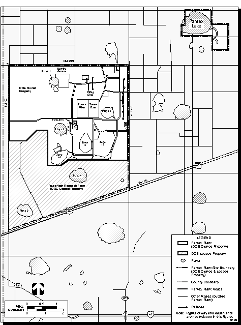
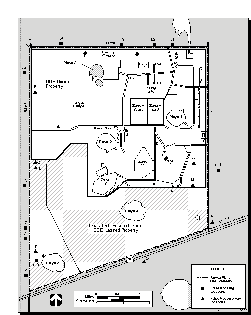
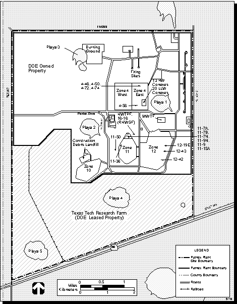
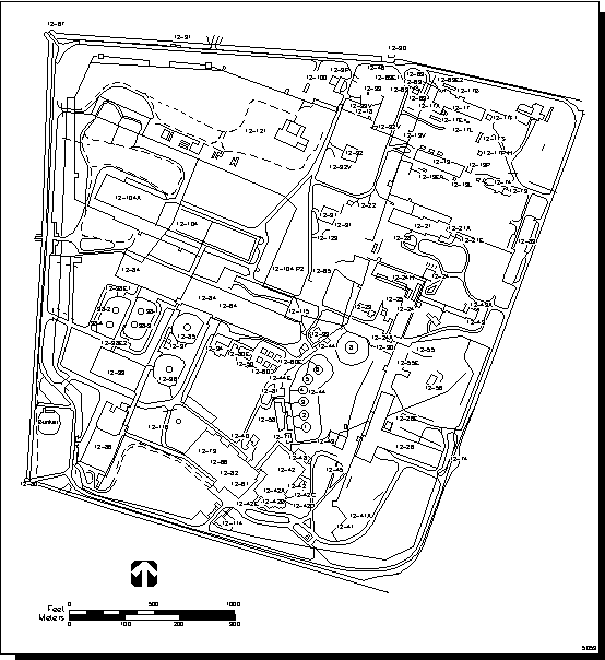
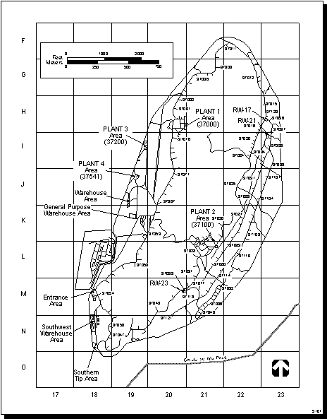
Figure 1.2-2 Location of Key Areas at Pantex Plant Site
Figure 1.2.2-1 Nuclear Weapons Design (.pdf)
Figure 1.2.2.1-1 Weapons Dismantlement and Pit Storage at Pantex Plant(.pdf)
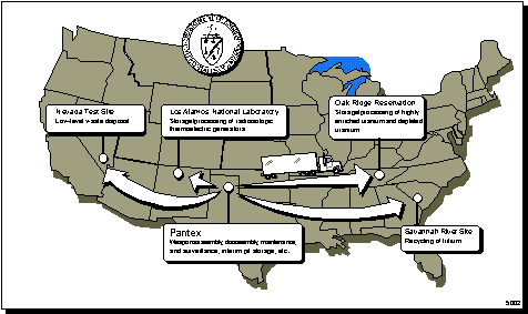
Figure 2.1-1 Sites That Receive Nuclear Components or Materials from Pantex Plant
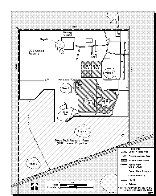
Figure 3.1.1-1 Location of Proposed Projects at Pantex Plant (.pdf)
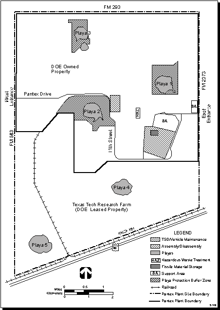
Figure 4.3.1.2-1 Pantex Plant Site in Carson County, Texas
Figure 4.4.1.1-1 Future Land Usage Projection of Pantex Plant Site Development Plan
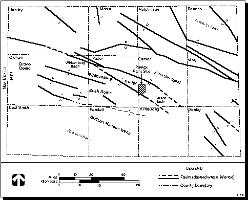
Figure 4.5.1.2-1 Pennsylvanian and Lower Permian Tectonic Structures
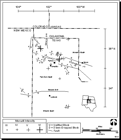
Figure 4.5.1.2-2 Earthquakes in the Texas Panhandle and Their Relation to Tectonic Features
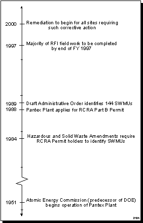
Figure 4.5.1.3-1 Timeline Showing Important Dates for Pantex Plant Environmental Restoration Program
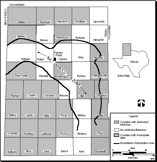
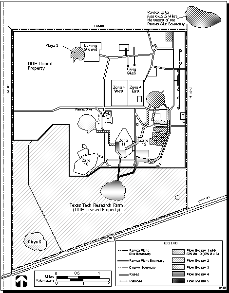
Figure 4.5.1.3-3 Pantex Ditches and Playas Flow Systems
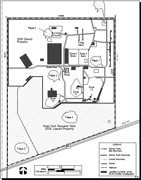
Figure 4.5.1.3-4 Landfills Currently Under RCRA Facility Investigation
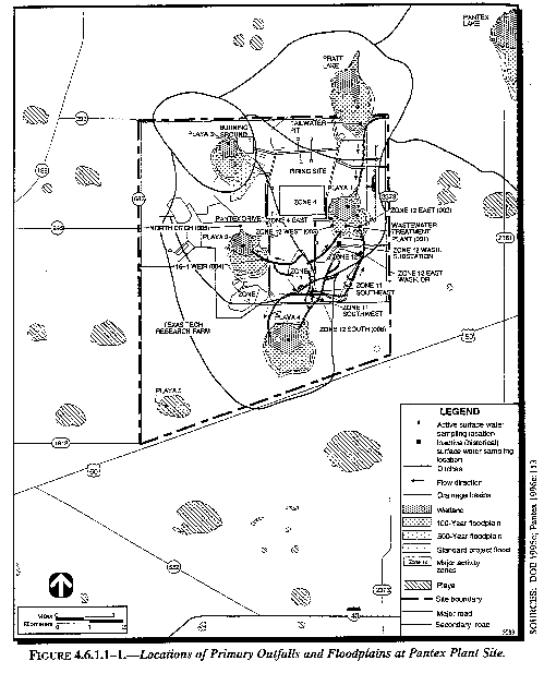
Figure 4.6.1.1-1 Locations of Primary Outfalls and Floodplains at Pantex Plant Site
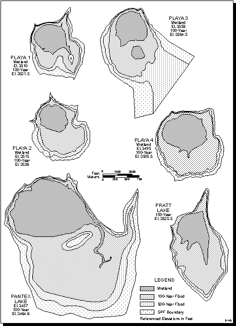
Figure 4.6.1.1-2 Detailed Floodplain Delineations for Playas 1-4, Pantex Lake, and Pratt Lake
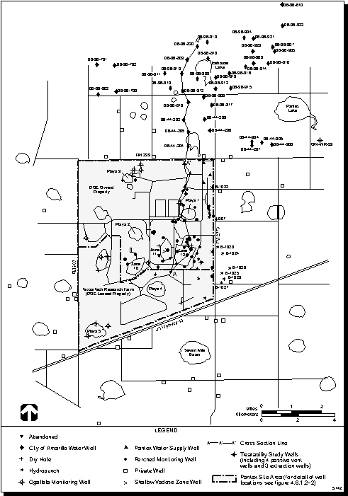
Figure 4.6.1.2-1 Locations of Pantex Plant Area Groundwater Wells
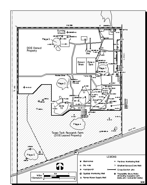
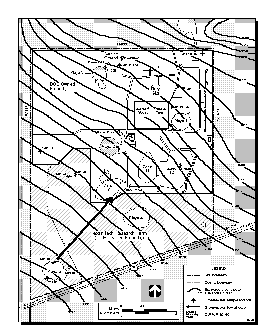
Figure 4.6.1.2-2 Groundwater Monitoring Locations, Pantex Plant Site
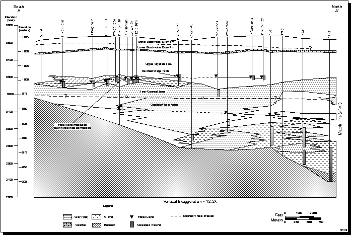
Figure 4.6.1.2-3 South-North Trending Hydrostatigraphic Cross-Section, Pantex Plant Site (A-A')
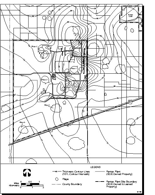
Figure 4.6.1.2-4 Thickness of the Fine-Grained Zone, Pantex Plant
Figure 4.6.1.2-5 Water Table Contour Map of the Perched Aquifer, Pantex Plant
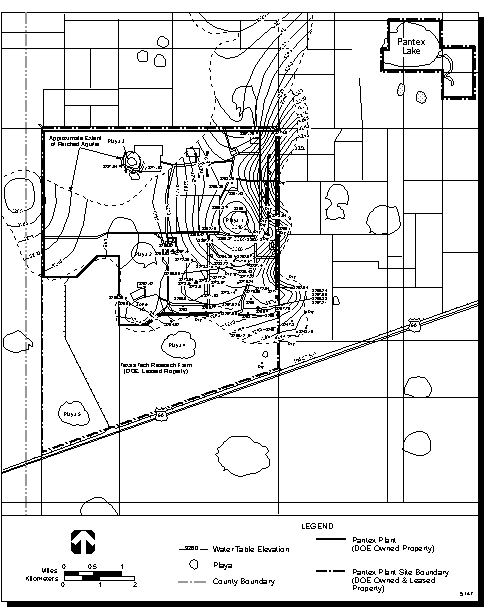
Figure 4.6.1.2-6 Contour Map of the Ogallala Aquifer, Pantex Plant
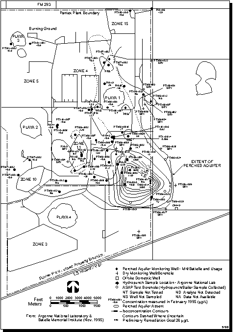
Figure 4.6.1.2-7 RDX Concentrations in the Perched Aquifer, Pantex Plant
Figure 4.6.1.2-8 Chromium Concentrations at OW-WR-20 from January 1992 through May 1995
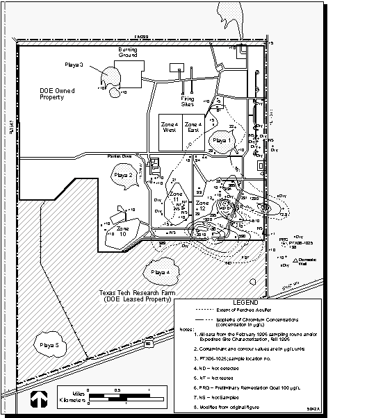
Figure 4.6.1.2-9 Chromium Concentrations in the Perched Aquifer, Pantex Plant
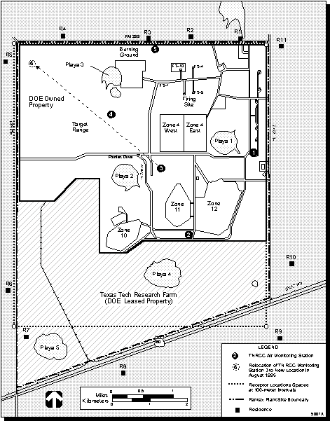
Figure 4.7.1.3-1 Air Quality Monitoring Stations at and Residences near Pantex Plant Site
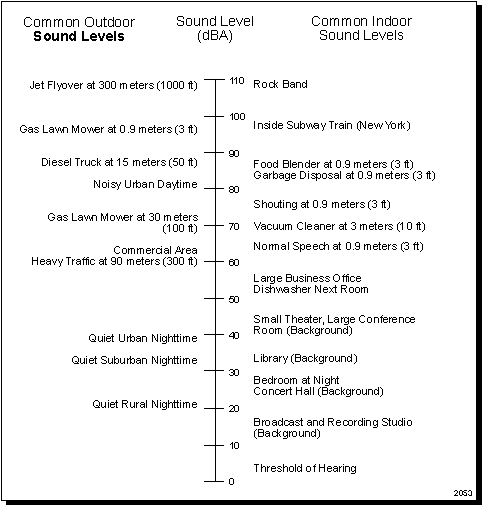
Figure 4.8.1-1 Comparative A-Weighted Sound Levels
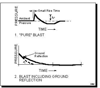
Figure 4.8.1.3-1 Typical Blast Impulses
Figure 4.11.1-1 Pantex Plant, Texas, and Its Socioeconomic Region of Influence
Figure 4.12.1.1-1 Stage Right Magazine
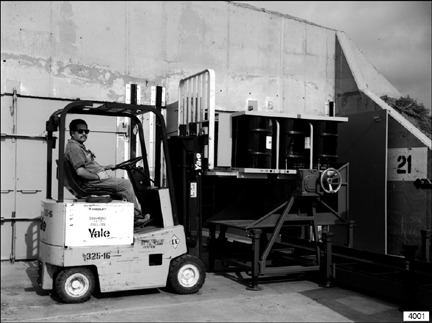
Figure 4.12.1.1-2 Placement of Stage Right Pallet on Pallet Turner
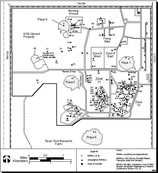
Figure 4.13.1.2-1 Waste Management Facility Locations at Pantex Plant
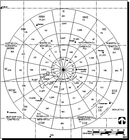
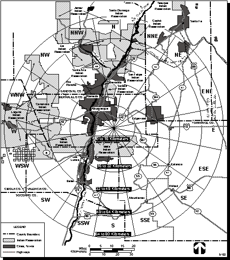
Figure 4.14.1-1 Population Within 80 kilometers (50 miles) of Pantex Plant
Figure 4.14.2.1-1 Evaluation of Risk (.pdf)
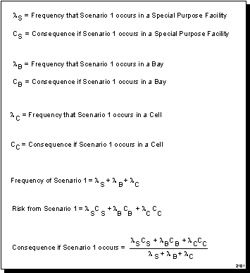
Figure 4.14.2.1-2 Consequence Calculation for Scenario 1
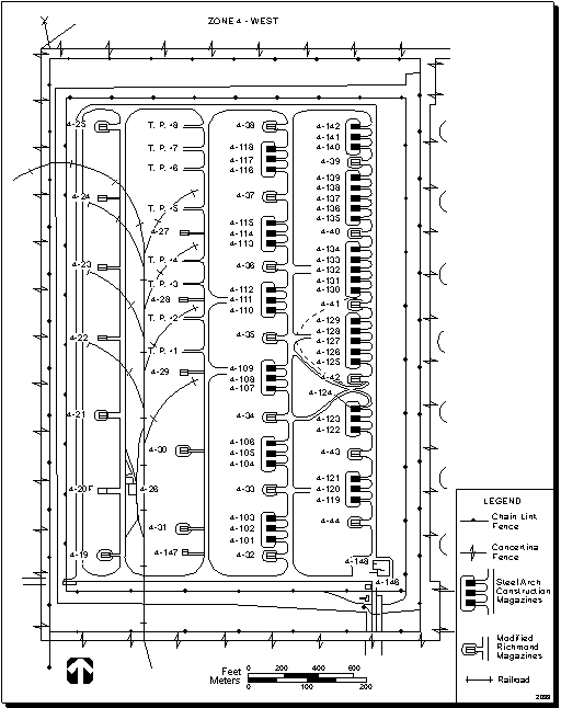
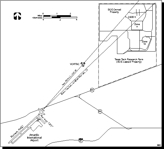
Figure 4.15.1.1-1 Layout of Zone 4 West
Figure 4.15.1.1-2 Layout of Zone 12 South
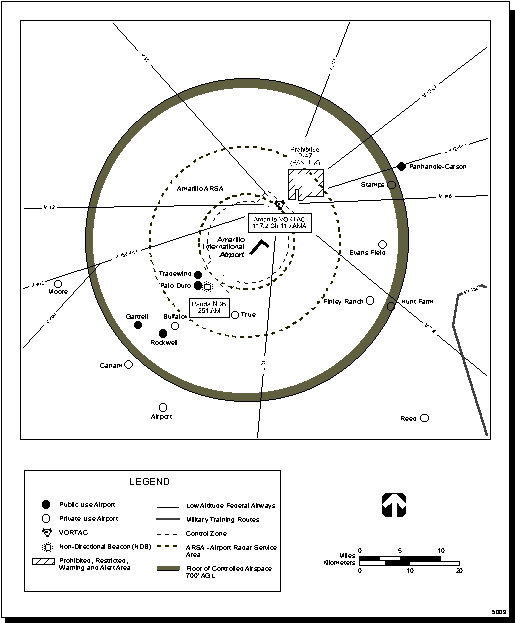
Figure 4.15.1.2-1 Current VORTAC Location and Low-Altitude Federal Airways
Figure 4.15.1.2-2 Current and Proposed Back Course Approaches
Figure 4.15.1.3-1 Global Positioning System Approach
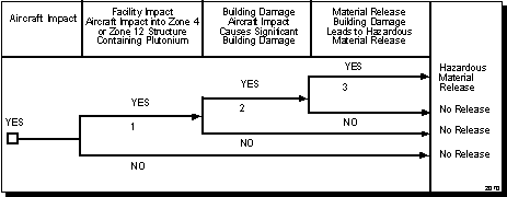
Figure 4.15.2-1 Aircraft Impact Event Tree
Figure 4.16.1.1-1 Los Alamos National Laboratory Delivery Location with Nearby Access Roads (.pdf)
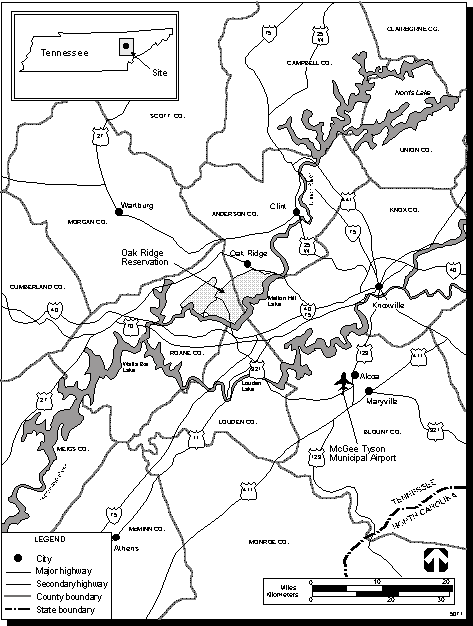
Figure 4.16.1.1-2 Oak Ridge Reservation,Tennessee, and Region
Figure 4.16.1.1-3 Access Roads to the Y-12 Plant at Oak Ridge Reservation (.pdf)
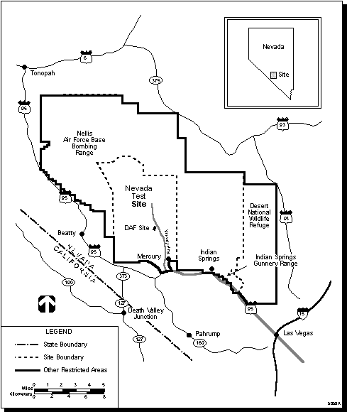
Figure 4.16.1.4-1 Roadways in the Vicinity of the Nevada Test Site
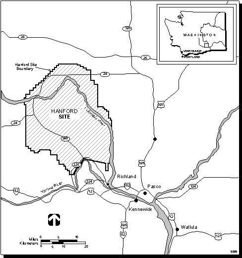
Figure 4.16.1.4-2 Roadways in the Vicinity of the Hanford Site
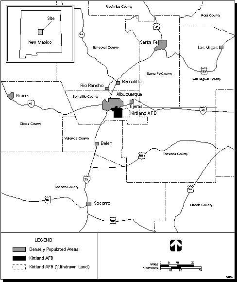
Figure 4.16.1.4-3 Roadways in the Vicinity of Kirtland Air Force Base
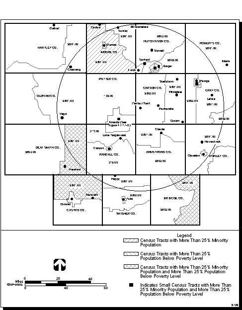
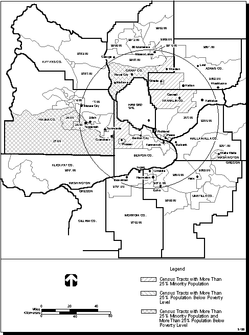
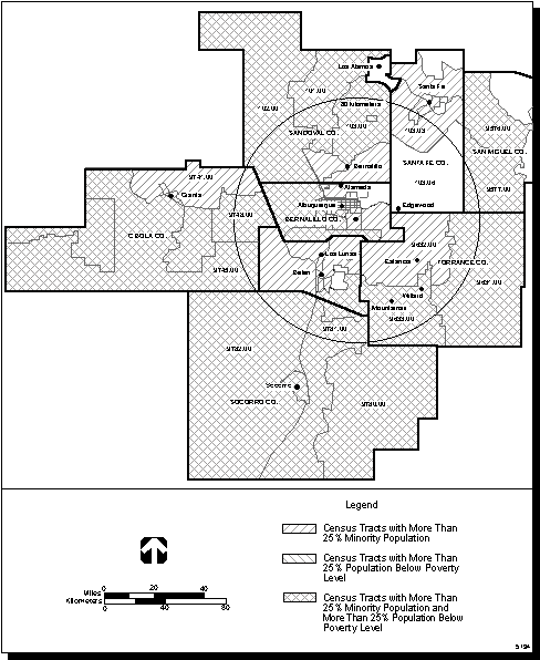
Figure 4.17.1-1 Minority and Low-Income Populations in the Pantex Plant Region of Influence, 1990
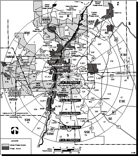
Figure 4.17.1-2 Minority and Low-Income Populations in th Amarillo Metropolitan Area, 1990
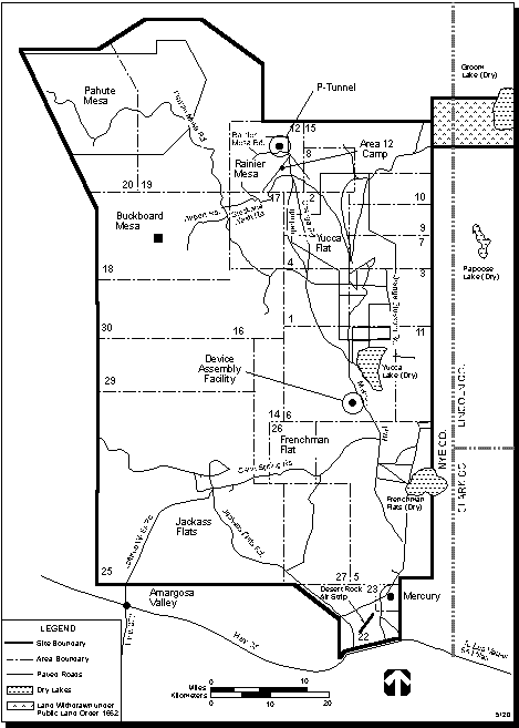
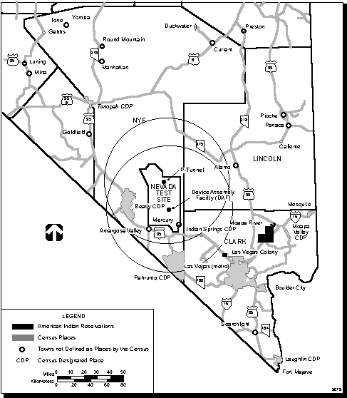
Figure 5.2-1 Location of Device Assembly Facility and P-Tunnel at the Nevada Test Site
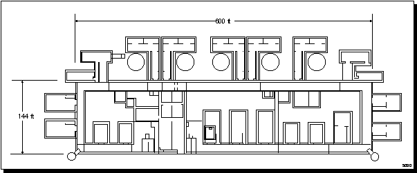
Figure 5.2-2 Simplified Layout of Device Assembly Facility at the Nevada Test Site
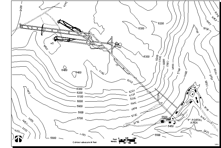
Figure 5.2-3 Layout of P-Tunnel at the Nevada Test Site
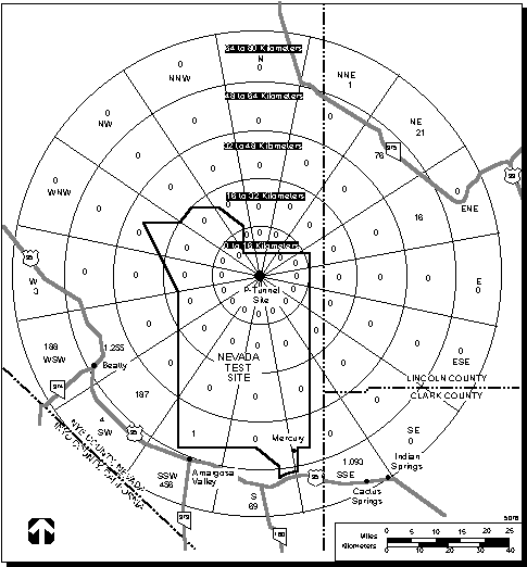
Figure 5.2.2.1-1 Population Within 80 kilometers (50miles) of Device Assembly Facility
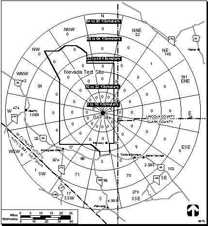
Figure 5.2.2.1-2 Population Within 80 kilometers (50 miles)of P-Tunnel
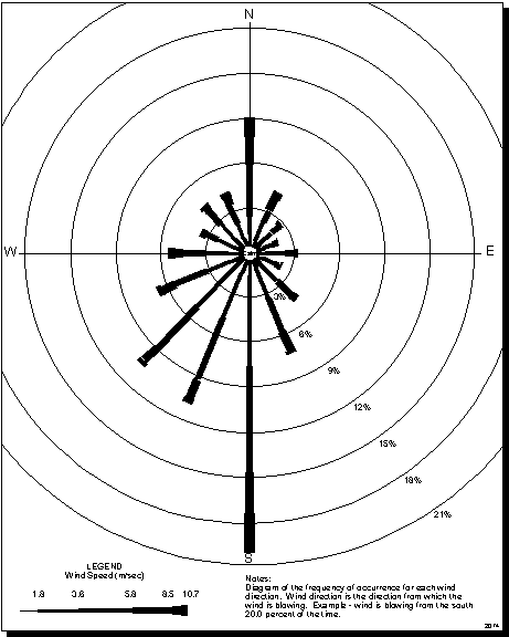
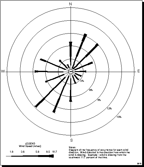
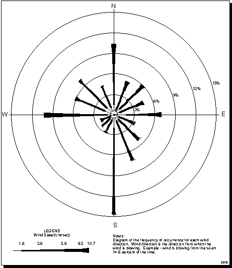
Figure 5.2.2.1-3 Wind Speed and Direction at the Nevada Test Site
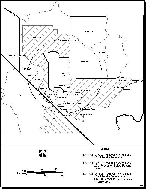
Figure 5.2.2.2-1 The Device Assembly Facility and P-Tunnel Regions of Influence in Nevada
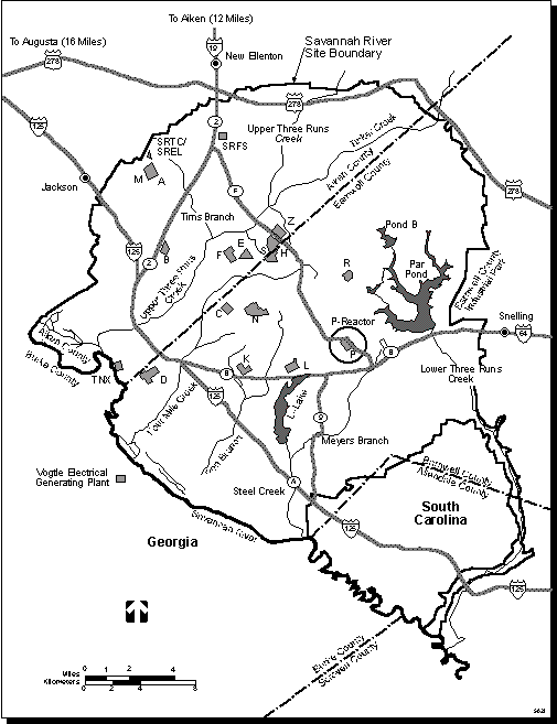
Figure 5.3-1 Location of P-Reactor at the Savannah River Site
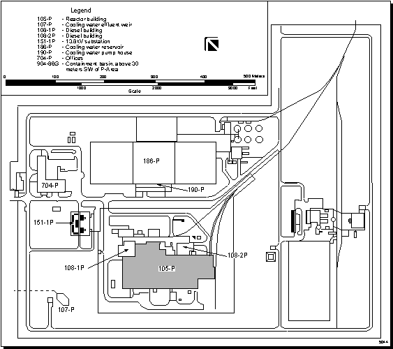
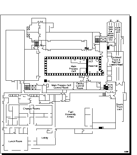
Figure 5.3-2 Layout of P-Reactor at the Savannah River Site
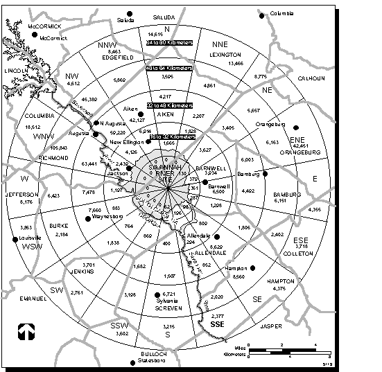
Figure 5.3.2.1-1 Offsite Population in the Vicinity of the Savannah River Site
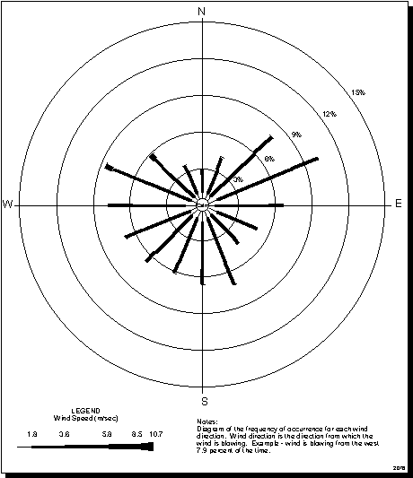
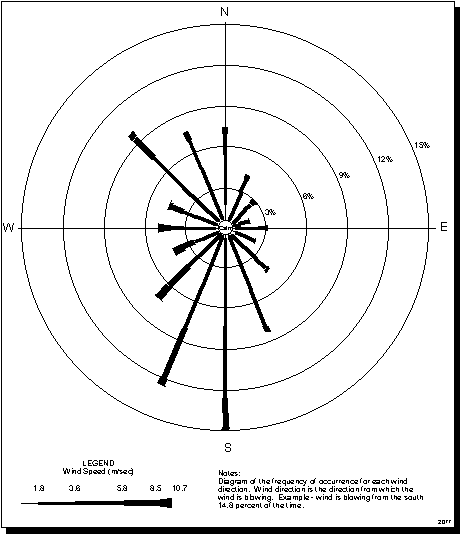
Figure 5.3.2.1-2 Wind Direction and Speed at the Savannah River Site, South Carolina, 1986
Figure 5.3.2.2-1 P-Reactor Region of Influence.
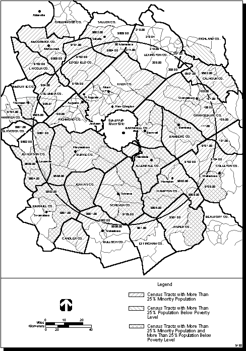
Figure 5.3.2.2-2 Minority and Low-Income Populations in the P-Reactor Region of Influence
Figure 5.4-1 Location of the Fuels and Materials Examination Facility at the Hanford Site
Figure 5.4-2 Layout of the Fuels and Materials Examination Facility
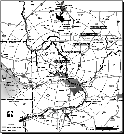
Figure 5.4.2.1-1 Offsite Population in the Vicinity of the Hanford Site
Figure 5.4.2.1-2 Wind Direction and Speed at the Hanford Site,Washington, 1994
Figure 5.4.2.2-1 The Fuels and Materials Examination Facility Region of Influence
Figure 5.5-2 Layout of the Manzano Weapons Storage Area at Kirtland Air Force Base
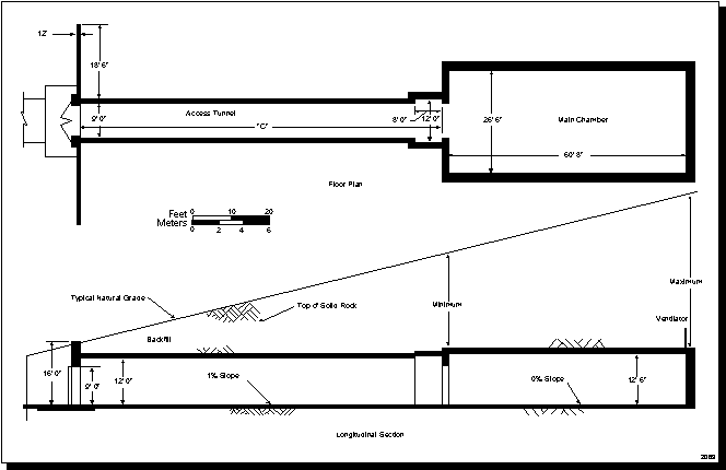
Figure 5.5.1.12-1 Type D Storage Facility at the Manzano Weapons Storage Area
Figure 5.5.2.1-1 Offsite Population in the Vicinity of the Manzano Weapons Storage Area
Figure 5.5.2.1-2 Wind Direction and Speed at Albuquerque International Airport
Figure 5.5.2.2-1 The Manzano WSA Region of Influence
Figure 5.5.2.2-2 Minority and Low-Income Populations in the Manzano WSA Region of Influence
Figure B.3.5-1 Air Quality Monitoring Stations, Emission Sources, and Receptor Sites at Pantex Plant (.pdf)
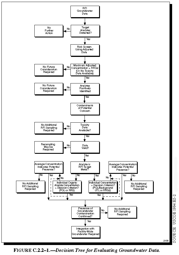
Figure C.2.2-1 Decision Tree for Evaluating Groundwater Data
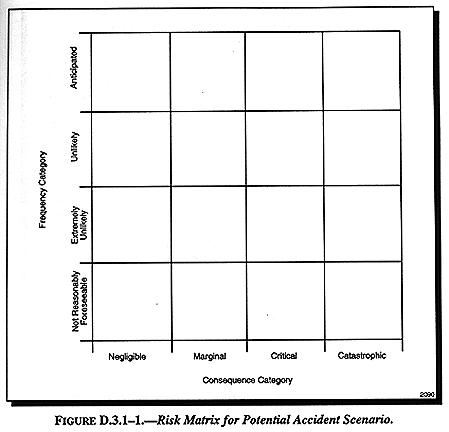
Figure D.3.1-1 Risk Matrix for Potential Accident Scenario
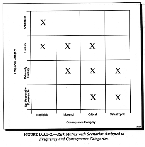
Figure D.3.1-2 Risk Matrix with Scenarios Assigned to Frequency and Consequence Categories
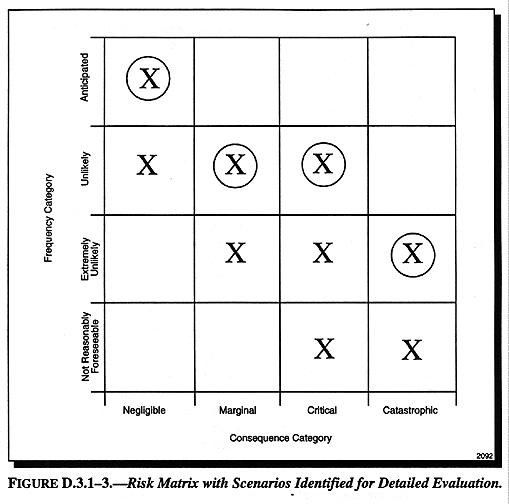
Figure D.3.1-3 Risk Matrix with Scenarios Identified for Detailed Evaluation
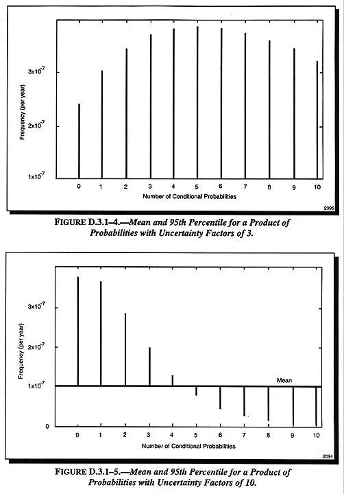
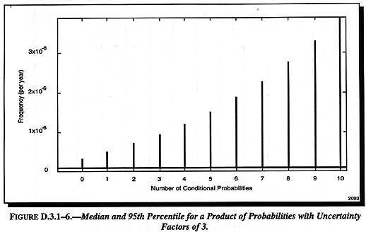
Figure D.3.1-4 Mean and 95th Percentile for a Product of Probabilities with Uncertainty Factors of 3
Figure E.3.1-1 Back Course Localizer Approach to the Amarillo International Airport
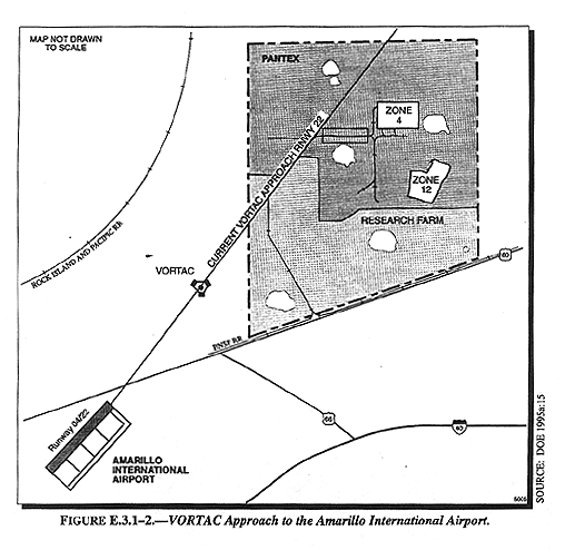
Figure E.3.1-2 VORTAC Approach to the Amarillo International Airport
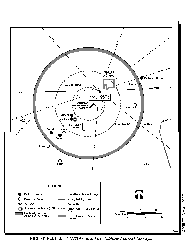
Figure E.3.1-3 VORTAC and Low-Altitude Federal Airways
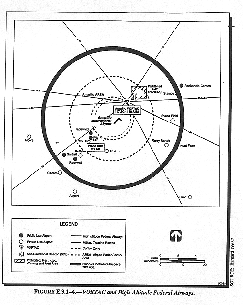
Figure E.3.1-4 VORTAC and High-Altitude Federal Airways
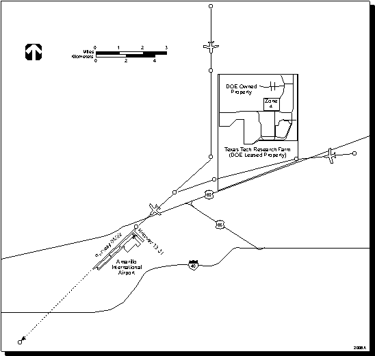
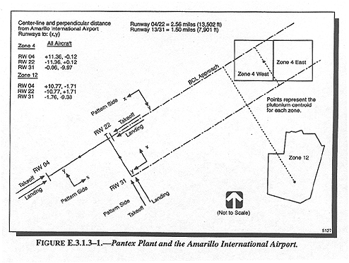
Figure E.3.1.3-1 Pantex Plant and the Amarillo International Airport
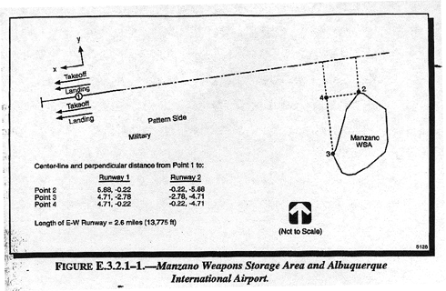
Figure E.3.2.1-1 Manzano Weapons Storage Area and Albuquerque International Airport
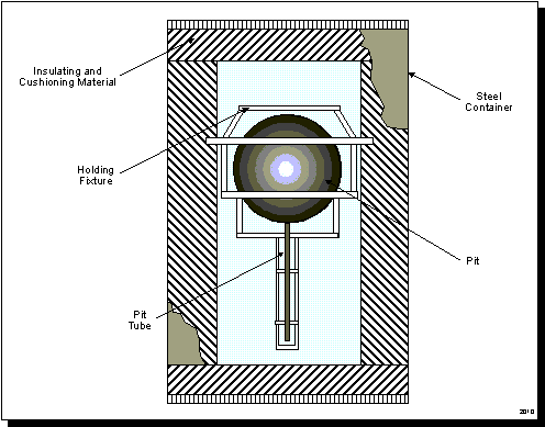
Figure F.3.1-1 Cross-Sectional View of AL-R8 Container
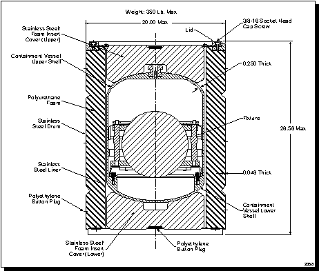
Figure F.3.2-1 Cross-Section View of FL-Type Container
Figure F.3.3-1 Cross-Section of an AT-400A Container
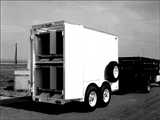
Figure F.4.2-1 Stage Right Trailer
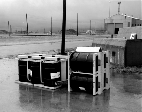
Figure F.4.3-1 Stage Right Pallet
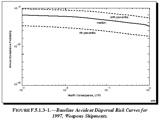
Figure F.5.1.3-1 Baseline Accident Dispersal Risk Curves for 1997 Weapons Shipments
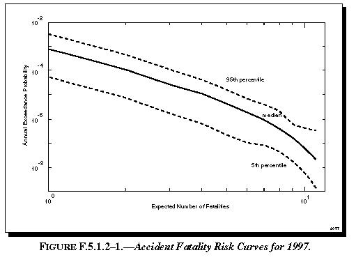
Figure F.5.1.2-1 Accident Fatality Risk Curves for 1997
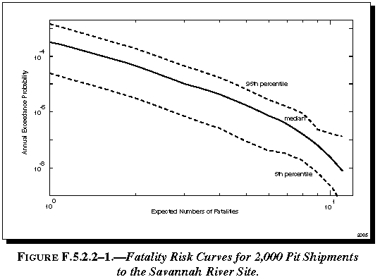
Figure F.5.2.2-1 Fatality Risk Curves for 2,000 Pit Shipments to the Savannah River Site
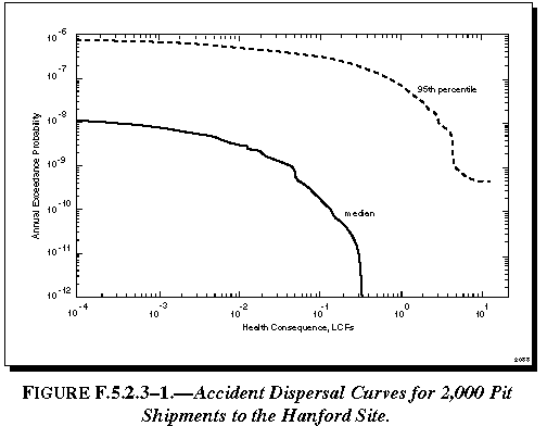
Figure F.5.2.3-1 Accident Dispersal Risk Curves for 2,000 Pit Shipments to the Hanford Site
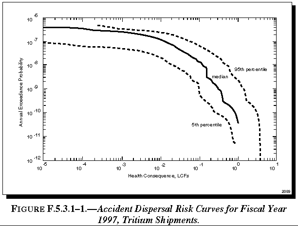
Figure F.5.3.1-1 Accident Dispersal Risk Curves for Fiscal Year 1997 Tritium Shipments
Figure F.6.2-1 Event Tree for Calculation of Facility Risk
Figure F.6.3.1-1 ADROIT Dispersal Event Tree Questions 1-5
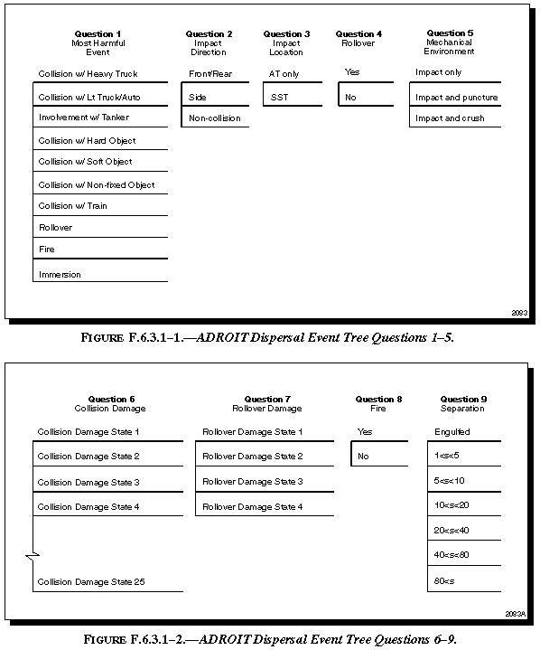
Figure F.6.3.1-2 ADROIT Dispersal Event Tree Questions 6-9
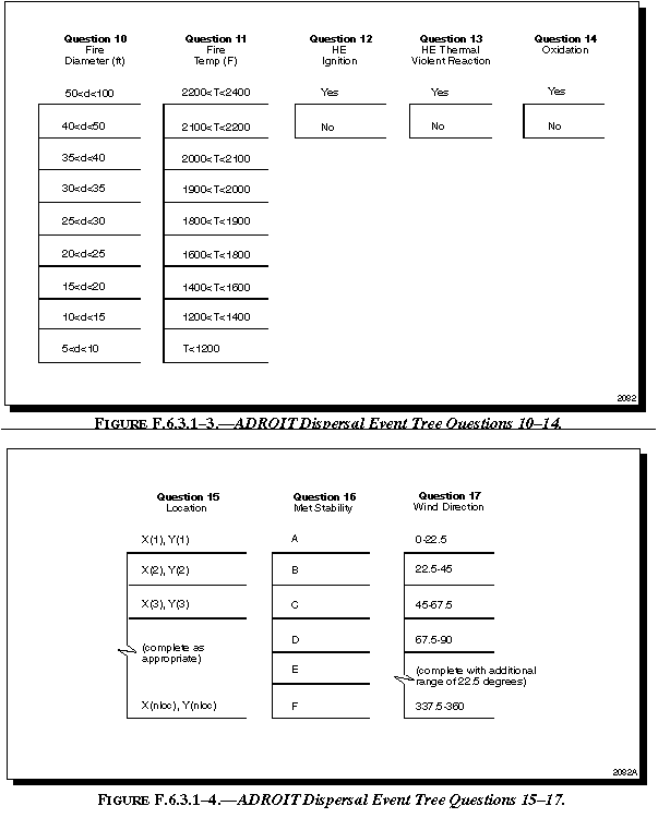
Figure F.6.3.1-3 ADROIT Dispersal Event Tree Questions 10-14
Figure F.6.3.1-4 ADROIT Dispersal Event Tree Questions 15-17
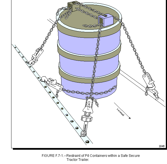
Figure F.7-1 Restraint of Pit Containers within a Safe Secure Tractor Trailer
Figure G.3.5-1 Tasks Required to Reach Waste Reduction Goal for Low Level Radioactive Waste
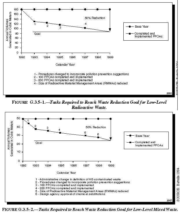
Figure G.3.5-2 Tasks Required to Reach Waste Reduction Goal for Low Level Mixed Waste
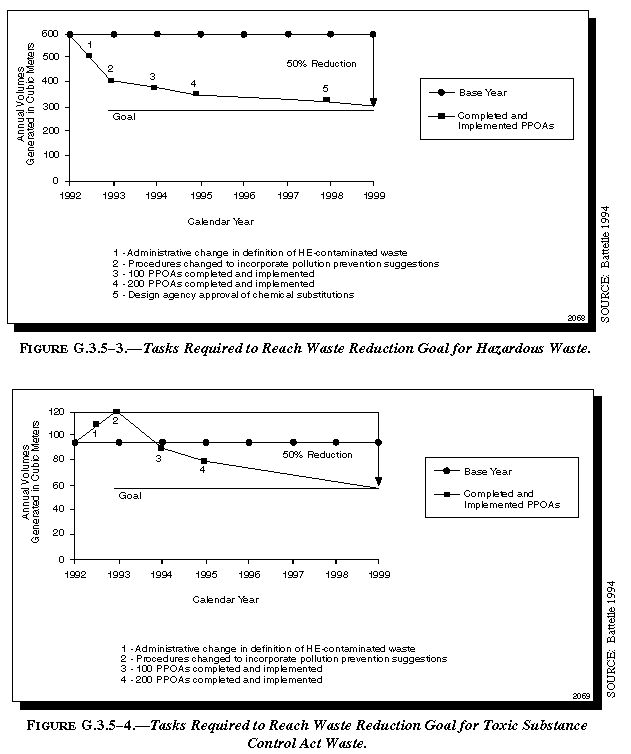
Figure G.3.5-3 Tasks Required to Reach Waste Reduction Goal for Low Level Hazardous Waste
Figure G.3.5-4 Tasks Required to Reach Waste Reduction Goal for Toxic Substance Control Act Waste
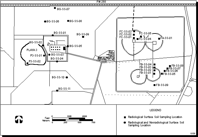
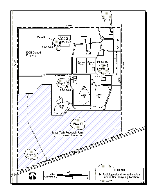
Figure I.1.2.1-1 Sampling Locations in the Vicinity of the Firing Sites and Burning Ground
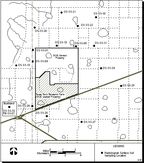
Figure I.1.2.1-2 Offsite Soil Sampling Locations
Figure I.1.2.1-3 Soil Sampling Locations at Playas 1,2 and 3
|
NEWSLETTER
|
| Join the GlobalSecurity.org mailing list |
|
|
|