


CHAPTER 3. AFFECTED ENVIRONMENT
The F-Area is an industrial area with buildings, paved parking
lots, and graveled areas.  While some grassed areas occur around
the administration buildings and vegetation is present along the
ditches that drain these areas, most of the area has little or no
vegetation.  Consequently, F-Area has little value as wildlife
habitat.  No aquatic habitat or wetlands occur in the F-Area.
Actions in this area would not affect threatened and endangered
species and their habitat.  The nearest red-cockaded
woodpecker (Picoides borealis) recruitment stand is more than
3.2 kilometers (2 miles) to the north.  No SRS facilities have been
nominated for inclusion in the National Register of Historic
Places, and there are no plans for such nomination.  Because the
F-Area is an industrial site constructed during the 1950s, the
presence of any important cultural resources remaining is
unlikely.
The Final Environmental Impact Statement, Continued Operation of
K-, L-, and P-Reactors, Savannah River Site, Aiken, South
Carolina (DOE 1990) presents a comprehensive discussion of the
Savannah River Site and its environs; that document provides a
supplement to the information in this chapter.
3.1 Geologic Setting and Seismicity
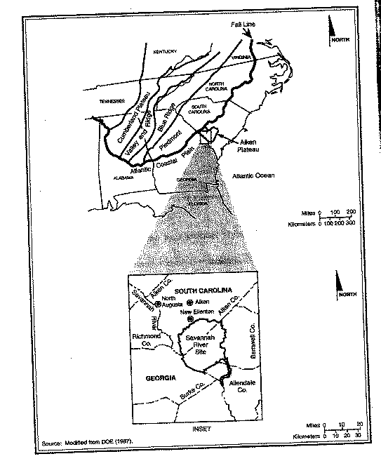
The Savannah River Site is on the Aiken Plateau of the Upper
Atlantic Coastal Plain about 40 kilometers (25 miles) southeast
of the Fall Line that separates the Atlantic Coastal Plain from
the Piedmont (Figure 3-1).  The F-Area is generally flat and
featureless with local relief as high as about 60 meters (190 feet)
and with slopes of 0 to 10 percent.  The Final Environmental Impact
Statement, Continued Operation of K-, L-, and P-Reactors, Savannah
River Site, Aiken, South Carolina (DOE 1990) contains a complete
description of the geologic setting and the stratigraphic
sequences of the SRS.  The Soil Survey of Savannah River Plant Area,
Parts of Aiken, Barnwell, and Allendale Counties, South Carolina
(USDA 1990) describes soil characteristics and erosion potential for the
area.
3.1.1 SUBSURFACE FEATURES
Several fault systems occur off the Site northwest of the Fall
Line (DOE 1990).  A recent study of available geophysical
evidence (Stephenson and Stieve 1992) identified six faults under the SRS:
the Pen Branch, Steel Creek, Advanced Tactical Training Area
(ATTA), Crackerneck, Ellenton, and
  Figure 3-1. General location of the Savannah River Site and relationship
             to physiographic provinces of the eastern United States.
Upper Three Runs Faults.  Figure 3-2 shows the locations of these
faults.  The Upper Three Runs Fault passes closest to F-Area.  The
fault lines on Figure 3-2 represent the projection of the faults
to the ground surface; the actual faults do not reach the surface
of the ground but stop several hundred feet below the surface.
Based on information developed to date, none of the faults
discussed in this section is "capable."  A fault is capable if it
has moved at or near the ground surface within the past 35,000
years or is associated with another fault that has moved in the
past 35,000 years.  For a more detailed definition of a capable
fault, see 10 CFR Part 100.
3.1.2 SEISMICITY
Two major earthquakes have occurred within 300 kilometers (186
miles) of the SRS.  The first was the Charleston, South Carolina,
earthquake of 1886, which had an estimated Richter scale
magnitude of 6.8 and occurred approximately 145 kilometers (90
miles) from the Site.  The SRS area experienced an estimated peak
horizontal acceleration of 10 percent of gravity (0.10g) during
this earthquake (URS/Blume 1982).  The second major earthquake
was the Union County, South Carolina, earthquake of 1913, which
had an estimated Richter scale magnitude of 6.0 and occurred
about 160 kilometers (99 miles) from the Site (Bollinger 1973).
Because these earthquakes are not associated conclusively with a
specific fault, researchers cannot determine the amount of
displacement resulting from them.
In recent years, two earthquakes occurred inside the SRS
boundary.  On June 8, 1985, an earthquake with a local Richter
scale magnitude of 2.6 and a focal depth of 0.96 kilometer
(0.59 mile) occurred on the Site; its epicenter was west of C- and
K-Areas.  The acceleration (measured in terms of a percentage of
the acceleration due to gravity) produced by the earthquake did
not activate instruments in the reactor areas, which were set to
detect an acceleration of about 0.015g or 1.5 percent of gravity.  On
August 5, 1988, an earthquake with a local Richter scale magnitude
of 2.0 and a focal depth of 2.68 kilometers (1.66 miles) occurred
on the Site; its epicenter was northeast of K-Area.  Existing
information does not correlate the two earthquakes conclusively
with the known faults on the Site.
Figure 3-2 shows the locations of the epicenters of these two
earthquakes.  A report on the August 1988 earthquake (Stephenson
1988) reviewed the latest earthquake history.  This report
predicts recurrence rates of one per year at a Richter scale
magnitude of 2.0 in the southeast coastal plain.  The report also
notes that historic data that could be used to calculate
recurrence rates accurately are sparse.
  Figure 3-2. Savannah River Site, showing seismic fault lines and locations
             of onsite earthquakes.
Most recently, a Richter scale magnitude 3.2 earthquake occurred
on August 8, 1993, approximately 16 kilometers (10 miles) east of
the City of Aiken near Couchton, South Carolina.  Residents
reported feeling this earthquake in Aiken, New Ellenton
(immediately north of the SRS), North Augusta (approximately 40
kilometers [25 miles] northwest of the SRS), and on the Site.
The accident analyses for this eis evaluated an earthquake of a
magnitude that would produce a peak ground acceleration of 0.2g,
which is estimated to recur at an interval of about once every
5,000 years.  The F-Canyon structure was designed to resist a
bomb blast impact against the exterior walls.  The acceleration
of the blast "front" from a nearby detonation would be many times
the acceleration due to gravity (32 feet per second squared).
For this reason, the structure would be highly damage-resistant
to an earthquake with a horizontal ground acceleration of 0.20g
or 20 percent of gravity at the structure base, although some
materials probably would be released.  A precise translation of
this acceleration to a Richter scale reading is not possible
because the impact at the F-Area would be greatly affected by the
type of soil in the area of the earthquake epicenter, the
nearness of a shallow fault line, and attenuation of the shock
wave in rock or other formations.
3.2 Water Resources
3.2.1 SURFACE-WATER AND GROUNDWATER FEATURES
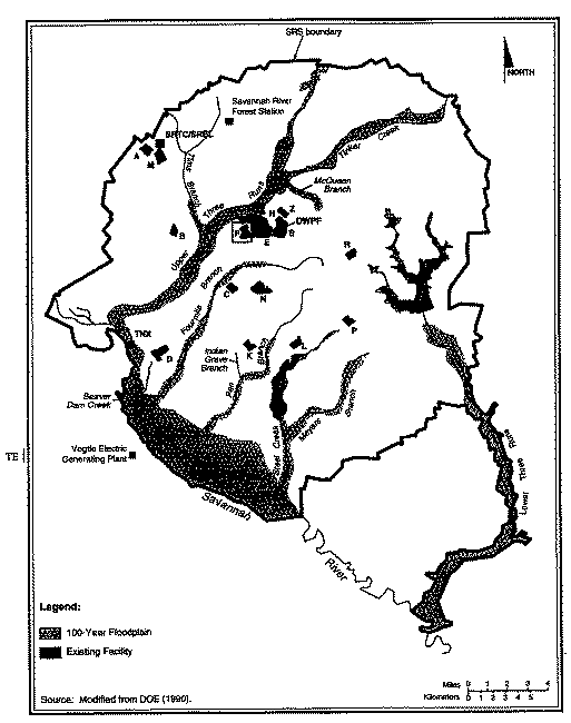
Six tributaries of the Savannah River - Upper Three Runs Creek,
Fourmile Branch, Beaver Dam Creek, Pen Branch, Steel Creek, and
Lower Three Runs Creek - drain almost all of the SRS (Figure 3-3).
Surface waters in the vicinity of the F-Area flow into Upper Three
Runs Creek and Fourmile Branch.  The F-Area is on a surface and
groundwater divide.  Shallow groundwater in the vicinity of the
area recharges both Upper Three Runs Creek and Fourmile Branch.
The Savannah River, which forms the boundary between the States
of Georgia and South Carolina, supplies potable water to several
municipalities.  Upstream from the SRS, the river supplies
domestic and industrial water needs for Augusta, Georgia, and
North Augusta, South Carolina.  Approximately 203 river kilometers
(126 river miles) downstream of the SRS, the river supplies
domestic and industrial water needs for the Cherokee Hill Water
Treatment Plant at Port Wentworth, Georgia, through intakes at
river kilometer 47 (river mile 29) and for Beaufort and Jasper
Counties in South Carolina through intakes at about river
kilometer 63 (river mile 39.2).
  Figure 3-3. Savannah River Site, showing 100-year floodplain and
             major stream systems.
Groundwater is a domestic, municipal, and industrial water source
throughout the Upper Coastal Plain.  Most municipal and
industrial water supplies in Aiken County are from the deep
aquifers.  Domestic water supplies are primarily from the
intermediate and shallow zone.  In Barnwell and Allendale
Counties, the intermediate zone and overlying units that thicken
to the southeast supply some municipal users.  At SRS most
groundwater production is from the deep zone, with a few lower-
capacity wells pumping from the intermediate zone.  Every major
operating area at SRS has groundwater wells.  Total groundwater
production at SRS is from 34,000 to 45,000 cubic meters (9 to 12
million gallons) per day, similar to the volume pumped for
industrial and municipal production within 16 kilometers (10
miles) of the Site (Arnett, Karapatakis, and Mamatey 1993).
Groundwater beneath the Site flows slowly toward SRS streams and
swamps and into the Savannah River at rates ranging from inches per year to
several hundred feet per year.  The depth to which the onsite
streams cut into the soils controls the horizontal movement of
groundwater.  The valleys of the smaller perennial streams allow
discharge from the shallow saturated geologic formations.  The
valleys of major tributaries of the Savannah River (e.g., Upper
Three Runs Creek) drain formations of intermediate depth, and the
valley of the Savannah River drains deep formations.
Groundwater flow in F-Area is upward, from the lower to the upper
sediments.  The horizontal flow direction from the F-Canyon
building is toward Upper Three Runs Creek and Fourmile Branch.
3.2.2 SURFACE-WATER AND GROUNDWATER QUALITY
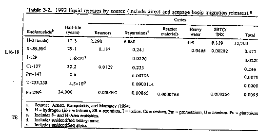
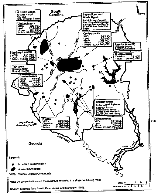
In 1993, the major releases of radionuclides from the SRS to
surface waters were 12,700 curies of tritium, 0.477 curie of
strontium-89 and -90, and 0.246 curie of cesium-137.  The resulting
doses from all radionuclides released from the Site were less
than 2 percent of applicable dose standards.  From a
nonradiological perspective, there was no significant difference
between upriver and downriver water quality parameters.  Other
than 72 instances of exceeding fecal coliform standards, river and
stream analyses met the more stringent 1992 updated river
classification of Freshwaters; that is, 99.9 percent of the
analyses were in compliance with the SRS National Pollutant
Discharge Elimination System permit.  Table 3-1 lists radioactive
liquid releases by source for 1993.
  Table 3-1.  1993 liquid releases by source (include direct and
            seepage basin migration releases).a
Industrial solvents, metals, tritium, and other constituents used
or generated on the Site have contaminated the shallow aquifers
beneath 5 to 10 percent of the SRS.  Figure 3-4 shows
groundwater contamination on the Site (Arnett, Karapatakis, and
Mamatey 1993).  Most contaminated groundwater at the SRS flows
beneath a few facilities; contaminants reflect the
operations and chemical processes performed at those facilities.
At F- and H-Areas, contaminants in the groundwater include tritium
and other radionuclides, metals, nitrates, chlorinated and
volatile organics.
Radioactive constituents (tritium, cesium-137, iodine-131,
ruthenium-106, and strontium-89 and -90) above drinking water
standards have occurred in F-Area monitoring wells.  One well
(FCA-9DR) showed activities considerably higher than others; strontium
activities were especially notable, as much as 1,000 more than
500 times over drinking water standards (Arnett, Karapatakis, and
Mamatey 1994).  Studies of flow directions, infiltration rates, and
operating history indicate that this contamination is from an
isolated incident that occurred more than 35 years ago (Reed
1993).
  Figure 3-4. Groundwater contamination at the Savannah River Site.
3.3 Air Resources
Based on SRS data collected from onsite meteorological towers for
the 5-year period from 1987 to 1991, maximum wind direction
frequencies are from the northeast and west-southwest and the
average wind speed is 3.8 meters per second (8.5 miles per hour)
(Shedrow 1993).  The average annual temperature at the SRS is
17.8-C (64-F).  The atmosphere in the SRS region is unstable
approximately 56 percent of the time, neutral 23 percent of the
time, and stable about 21 percent of the time (Shedrow 1993).  In
general, as the atmosphere becomes more unstable, atmospheric
dispersion of airborne pollutants increases and ground-level
pollutant concentrations decrease.
3.3.1 SEVERE WEATHER CONDITIONS
The SRS area experiences an average of 55 thunderstorm days per
year with 50 percent of these occurring in June, July, and August
(Shedrow 1993).  On an annual average, lightning flashes will
strike six times per year on a square-kilometer area (Hunter 1990).
The highest windspeed recorded at Bush Field (Augusta, Georgia)
between 1950 and 1990 was 100 kilometers (62 miles) per hour
(NOAA 1990).
From 1954 to 1983, 37 reported tornadoes occurred in a 1-degree
square of latitude and longitude that includes the SRS (WSRC
1993a).  This frequency of occurrence is equivalent to an average
of about one tornado per year.  The estimated probability of a
tornado striking a point on the SRS is 0.0000711 per year.  This
results in a point-strike recurrence interval of about once every
14,000 years (Bauer et al. 1989).  Since operations began at the
SRS in 1953, nine tornadoes have been confirmed on or near the
Site.  Nothing more than light damage was reported, with the
exception of a tornado in October 1989 that caused considerable
damage to forest resources in an undeveloped southeastern sector
of the SRS (Shedrow 1993).
From 1700 to 1992, 36 hurricanes occurred in South Carolina,
resulting in an average frequency of about one hurricane every 8
years (WSRC 1993a).  Because SRS is about 160 kilometers (100
miles) inland, the winds associated with hurricanes have usually
diminished below hurricane force [i.e., equal to or greater than
a sustained wind speed of 33.5 meters per second (75 miles per
hour)] before reaching the SRS.  Winds exceeding hurricane force
have been observed only once at SRS (Hurricane Gracie in 1959)
(Shedrow 1993).
3.3.2 RADIOLOGICAL AIR QUALITY
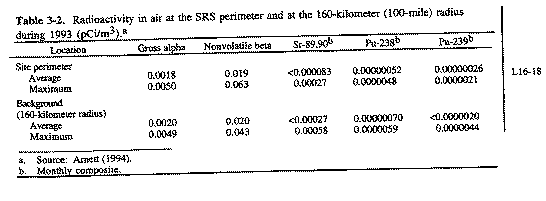
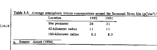
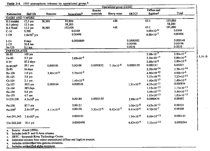
DOE provides detailed summaries of radiological releases to the
atmosphere from SRS operations along with the resulting
concentrations and doses in a series of annual environmental data
reports.  This section references several of these documents,
which contain information additional to that presented in the
following paragraphs.  The information enables comparisons of
current data with releases, concentrations, and doses associated
with each alternative.
In the SRS region, airborne radionuclides originate from natural
sources (i.e., terrestrial and cosmic), worldwide fallout, and
Site operations.  The SRS maintains a network of air monitoring
stations on and around the Site to determine concentrations of
radioactive particulates and aerosols in the air
(Arnett, Karapatakis, and Mamatey 1994).
Table 3-2 lists average and maximum nontritium atmospheric
radionuclide concentrations at the SRS boundary and at background
monitoring locations [160-kilometer (100-mile) radius] during 1993.
Tritium is the only radionuclide of SRS origin detected routinely
in offsite air samples above background (control) concentrations
(Cummins, Martin, and Todd 1990, 1991; Arnett et al. 1992;
Arnett, Karapatakis, and Mamatey 1993).  Table 3-3 lists average
concentrations of tritium in the atmosphere, as measured at the
boundary and offsite monitoring locations.
  Table 3-2. Radioactivity in air at the SRS perimeter and at the 160-
            kilometer (100-mile) radius during 1993 (pCi/m3).a
  Table 3-3. Average atmospheric tritium concentrations around the Savannah
            River Site (pCi/m3).a
Table 3-4 lists 1993 radionuclide releases from each major
operational group of SRS facilities.  All radiological impacts
are within regulatory requirements.
3.3.3 NONRADIOLOGICAL AIR QUALITY
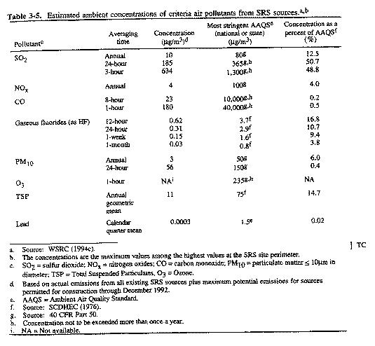
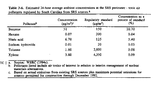
The SRS is in the Augusta (Georgia) - Aiken (South Carolina)
Interstate Air Quality Control Region (AQCR).  This region, which
is designated as a Class II area, is in compliance with National
Ambient Air Quality Standards (NAAQS) for criteria pollutants.
(Class II is the initial designation of any area that is not
considered a pristine area; pristine areas include international
parks or National wilderness areas).  The criteria pollutants
include sulfur dioxide, nitrogen oxides (reported as nitrogen
dioxide), particulate matter (less than or equal to 10 microns),
carbon monoxide, ozone, and lead (40 CFR Part 50).
DOE utilized the comprehensive emissions inventory data for 1990
to establish the baseline year for showing compliance with
national and state air quality standards by calculating actual
emission rates for existing sources.  DOE based its calculated
emission rates for the sources on process knowledge, source
testing, material balance, and U.S. Environmental Protection
Agency (EPA) Air Pollution Emission Factors (AP-42; EPA 1985).
The inventory also included maximum potential emissions for
sources permitted for construction through 1992.
DOE performs no onsite ambient air quality monitoring.  State
agencies operate ambient air quality monitoring sites in Barnwell
and Aiken Counties in South Carolina and Richmond County in
Georgia.
DOE has performed atmospheric dispersion modeling for criteria
and toxic air pollutants for actual emissions for the base year
1990 (plus potential emissions for sources permitted for
construction), using the EPA Industrial Source Complex Short Term
No. 2 Model.  This model used data from the SRS meteorological
tower for 1991 along with the 1990 emissions data to estimate
maximum
  Table 3-4. 1993 atmospheric release by operational group.a
ground-level air pollutant concentrations at the SRS perimeter.
DOE added the incremental impacts associated with the
alternatives evaluated in this eis to the baseline concentrations
to estimate total air quality impacts.
The South Carolina Department of Health and Environmental Control
(SCDHEC) has air quality regulatory authority over the SRS and
determines ambient air quality compliance based on SRS air
pollutant emissions and estimates of concentrations at the Site
perimeter based on atmospheric dispersion modeling.  The SRS is
in compliance with National Ambient Air Quality Standards for
criteria pollutants and gaseous fluoride and total suspended
particulate standards, as required by SCDHEC Regulation
R.61-62.5, Standard 2, "Ambient Air Quality Standards" (AAQS).
Table 3-5 lists these standards and the results of the atmospheric
dispersion modeling for base year 1990.
The SRS is in compliance with SCDHEC Regulation R.61-62.5,
Standard 8, "Toxic Air Pollutants," which regulates the emission
of 257 toxic air pollutants (WSRC 1994c).  DOE has identified emission
sources for 139 of the 257 regulated air toxics; the modeled
results indicate that the Site is in compliance with SCDHEC air
quality standards.  Table 3-6 lists toxic air pollutants that are
the same as those that the alternative actions described in this eis
will emit.  Table 3-6 also compares maximum downwind concentrations at
the Site boundary for base year 1990 to SCDHEC standards for toxic air
pollutants.
3.4 Socioeconomics
This section discusses baseline socioeconomic conditions in a
region of influence where approximately 90 percent of the SRS
workforce lived in 1992.  The SRS region of economic influence
includes Aiken, Allendale, Bamberg, and Barnwell Counties in
South Carolina, and Columbia and Richmond Counties in Georgia.
Socioeconomic Characteristics of Selected Counties and Communities
Adjacent to the Savannah River Site (HNUS 1992) contains additional
information on the economic and demographic characteristics of
the six-county region.
3.4.1 EMPLOYMENT
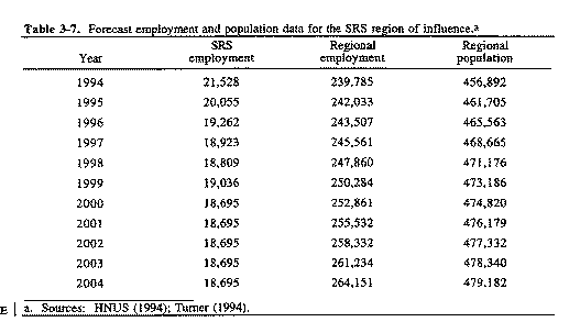
Between 1980 and 1990, total employment in the six-county region
increased from 139,504 to 199,161, an average annual growth rate
of approximately 5 percent.  The unemployment rates for 1980 and
1990 were 7.3 percent and 4.7 percent, respectively (HNUS 1992).
Table 3-7 lists projected employment data for the region, which
indicate that regional employment should increase to approximately
264,000 by 2004 (HNUS 1994).
  Table 3-5.  Estimated ambient concentrations of criteria air
             pollutants from SRS sources.a,b
In Fiscal Year 1992, employment at the SRS was 23,351,
approximately 10 percent of regional employment, with an
associated payroll of more than $1.1 billion.  Site employment in
2000 is likely to decrease to approximately 18,700 (Turner 1994),
which would represent 7 percent of regional employment.
Employment is likely to continue to decrease in subsequent
years.
3.4.2 POPULATION
Between 1980 and 1990, population in the region of influence
increased 13 percent, from 376,058 to 425,607.  More than 88
percent of the 1990 population lived in Aiken County (28.4
percent),
  Table 3-6.  Estimated 24-hour average ambient concentrations at
           the SRS perimeter - toxic air pollutants regulated by South
           Carolina from SRS sources.a
  Table 3-7. Forecast employment and population data for the SRS
            region of influence.a
Columbia County (15.5 percent), or Richmond County (44.6
percent).  Table 3-7 lists population data for the region of
influence forecast to 2004.  According to census data, in 1990
the estimated average number of persons per household in the
six-county region was 2.72, and the median age of the population
was 31.2 years (HNUS 1992).
3.4.3 COMMUNITY CHARACTERISTICS
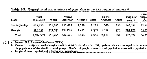
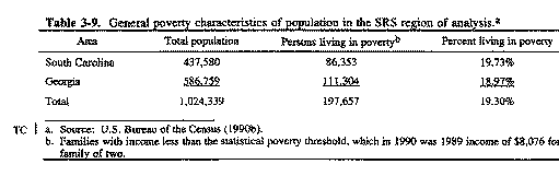
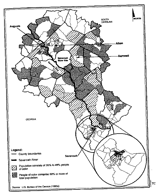
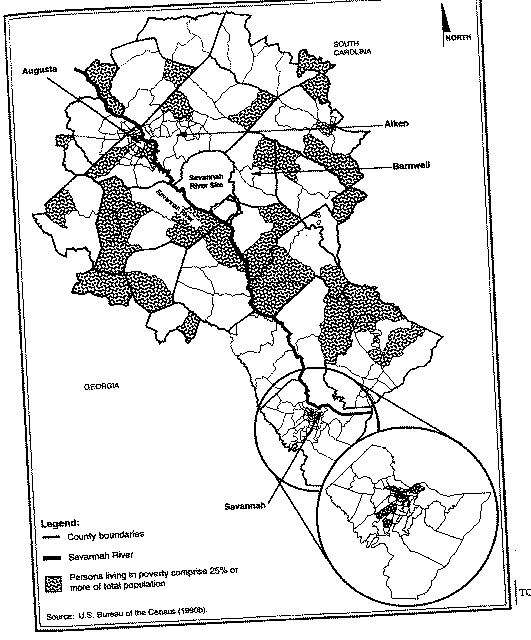
Executive Order 12898, Federal Actions to Address Environmental
Justice in Minority Populations and Low-Income Populations,
requires that Federal agencies identify and address, as
appropriate, disproportionately high and adverse human health or
environmental effects of their programs and activities on
minority and low-income populations; minority populations are
hereafter referred to as people of color.  DOE is in the process
of developing official guidance on the implementation of the
Executive Order; in addition, the Department is a participating
member of the Interagency Working Group on Environmental Justice,
which is developing definitions for environmental justice
analyses. The guidance that the Working Group and DOE eventually develops
might depart somewhat from the approach taken in this eis for
analysis of environmental justice issues.  This approach is intended to
identify the potential effects from onsite activities on
individuals in the identified communities of people of color or
low income.  The following discussion describes the framework for
analysis of environmental justice issues for the alternatives
considered in this eis.
The potential offsite health impacts would result from releases
to the air and to Savannah River water downstream of the SRS.
For air releases, standard population dose analyses are based on
an 80-kilometer (50-mile) radius because expected dose levels
beyond that distance are negligible.  For liquid releases, the
region of interest includes areas along the river that draw on
the river for drinking water (Beaufort and Jasper Counties in
South Carolina and Port Wentworth in Georgia).  Combining
these two areas, the analysis included U.S. Bureau of the Census
data for populations in all census tracts that have at least
20 percent of their area in the 80-kilometer (50-mile) radius and
all tracts from Beaufort and Jasper Counties in South Carolina
and Effingham and Chatham Counties in Georgia, which are downstream of the
Site.  DOE used data from each census tract in this combined
region to identify the racial composition of communities and the
number of persons characterized by the U.S. Bureau of the Census
as living in poverty.  The combined region contains 245 census tracts,
98 in South Carolina and 147 in Georgia.
Tables 3-8 and 3-9 list racial and economic characteristics,
respectively, of the population within the combined region.
Table 3-8 indicates a total population of more than 1 million in
the combined area.  Of that total population, approximately
652,000 (63.6 percent) are white.  Within the population of
people of color, approximately 95 percent are African American.
The remainder of the population of people of color is made up of
small percentages of Asian, Hispanic, and Native American
persons.  Figure 3-5 shows racial distribution of people of color
by census tract areas within the SRS region.
  Table 3-8.  General racial characteristics of population in the SRS
           region of analysis.a
  Table 3-9.  General poverty characteristics of population in the
             SRS region of analysis.a
Executive Order 12898 does not define minority populations.  One
approach to identifying minority communities would be to identify
those communities that contain a simple majority of people of
color (greater than or equal to 50 percent of the total community
population).  A second approach, identified by EPA, is that for
environmental justice purposes, communities of people of color
are defined as those that have higher-than-average (over the
region of interest) percentages of minority persons (EPA 1994).
In Figure 3-5 shaded areas show census tracts where (Approach 1)
people of color comprise 50 percent or more (simple majority) of
the total population in the census tract, or (Approach 2) people of
color comprise less than 50 percent but more than 36 percent of the
total population in the census tract. For purposes of analysis,
DOE has adopted Approach 2, which is more expansive in this eis.
In the combined region, 84 tracts (34.3 percent) contain
concentrations of people of color that are equal to or greater
than 50 percent of the total population of the tract.  In an
additional 33 tracts (13.5 percent), people of color comprise
between 36 and 50 percent of the population.  These tracts are
well distributed throughout the region, although weighted toward
the south and with higher concentrations in the immediate
vicinities of Augusta and Savannah, Georgia.
  Figure 3-5. Racial distribution of census tracts in SRS region.
Low-income communities generally are defined as those in which 25
percent or more of the population is characterized as living
in poverty (EPA 1993).  The U.S. Bureau of the Census
characterizes persons in poverty as those whose income is less
than a "statistical poverty threshold." This threshold is a weighted
average based on family size and the age of the persons in the family.
The baseline threshold for the 1990 census was a 1989 income of $8,076
for a family of two.
Table 3-9 indicates that in the SRS region, more than 197,000
persons (19.3 percent of the total population) are characterized
as living in poverty.  In Figure 3-6, shaded census tracts in the
region identify low-income communities.  In the region, 77 tracts
(31.4 percent) are identified as low-income communities.  These
tracts are distributed throughout the region, although more exist
to the south of the SRS.  As discussed in Chapter 4, no adverse
health effects are expected to occur in any offsite community,
including minority and low-income communities.
3.5 Occupational and Public Health
3.5.1 PUBLIC RADIOLOGICAL HEALTH
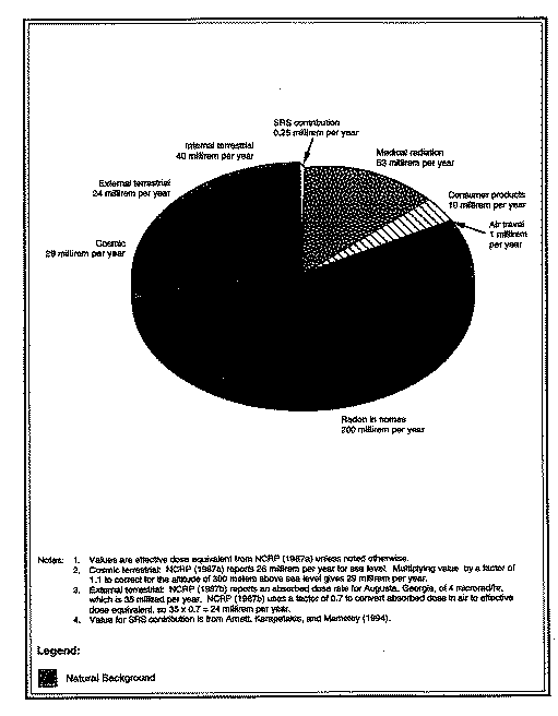
The release of radioactivity to the environment from any nuclear
facility is a sensitive issue for onsite workers and the public.
Because there are many other sources of radiation in the human
environment, evaluations of radioactive releases from nuclear
facilities must consider all the ionizing radiation to which
people are routinely exposed.
Public radiation exposure in the vicinity of the Site amounts to
approximately 357 millirem per year, consisting of natural
background radiation from cosmic, terrestrial, and internal body
sources; radiation from medical diagnostic and therapeutic
practices; radiation from weapons test fallout; radiation from
consumer and industrial products; and radiation from nuclear
facilities.  Figure 3-7 shows the relative contributions of each
source to people living in the vicinity of the Site.  All
radiation doses mentioned in this eis are "effective dose
equivalents"; internal exposures are reported as "committed
effective dose equivalents."
Releases of radioactivity to the environment from the Site
account for less than 0.1 percent of the total annual average
environmental radiation dose to individuals within 80 kilometers
(50 miles) of the Site.  Natural background radiation contributes
about 293 millirem per year or 82 percent of the annual dose of
357 millirem received by an average member of the population
within 80 kilometers (50 miles) of the Site.  Based on national
averages, medical exposure accounts for an additional
  Figure 3-6. Low-income distribution of census tracts in SRS region
  Figure 3-7.  Major sources of radiation exposure in the vicinity
            of Savannah River Site.
14.8 percent of the annual dose, and the combined doses from
weapons test fallout, consumer and industrial products, and air
travel account for about 3 percent of the total dose (NCRP
1987a).
Other nuclear facilities within 80 kilometers (50 miles) of the
Site include a low-level waste burial site operated by
Chem-Nuclear Systems, Inc., near the eastern SRS boundary, and
the Georgia Power Company's Vogtle Electric Generating Plant,
directly across the Savannah River from the Site.  In
addition, Carolina Metals, Inc., which is northwest of Boiling
Springs in Barnwell County, processes depleted uranium.  The South
Carolina Department of Health and Environmental Control annual
report for 1992 on nuclear facility monitoring (SCDHEC 1992)
documents that the Chem-Nuclear and Carolina Metals Facilities
do not appear to influence radioactivity levels in the air,
precipitation, groundwater, soil, vegetation, or external radiation,
based on State measurements.  Plant Vogtle began commercial operation
in 1987; in 1991, releases from the plant produced a maximally exposed
individual dose of 0.00017 rem at the plant boundary and a total
population dose within an 80-kilometer (50-mile) radius of 0.057
person-rem (NRC 1994).
In 1993, releases of radioactive material to the environment from
SRS operations resulted in a maximum Site perimeter individual
dose from atmospheric releases of 0.11 millirem per year in the
north-northwest sector around the Site, and a maximum dose from
liquid releases of 0.14 millirem per year, for a maximum total
annual dose at the Site perimeter of 0.25 millirem.  The maximum
dose to downstream consumers of Savannah River water - 0.05
millirem per year - occurred to Port Wentworth public water
supply users (Arnett 1994).
In 1990 the population within 80 kilometers (50 miles) of the
Site was approximately 620,100.  The collective effective dose
equivalent to that population in 1993 was 7.6 person-rem from
atmospheric releases.  The 1990 population of 65,000 people using
water from the Cherokee Hill Water Treatment Plant near Port Wentworth,
Georgia, and the Beaufort-Jasper Water Treatment Plant near Beaufort,
South Carolina, received a collective dose equivalent of 1.5
person-rem (Arnett 1994).  Population statistics indicate that
cancer caused 23.5 percent of the deaths in the United States in
1990 (CDC 1993).  If this percentage of deaths from cancer continues,
23.5 percent of the U.S. population will contract a fatal cancer from all
causes.  Thus, in the population of 620,100 within 80 kilometers
(50 miles) of the Site, 145,700 persons will be likely to contract
fatal cancers
from all causes.
The total population dose from the SRS of 9.1 person-rem (i.e.,
7.6 person-rem from atmospheric pathways plus 1.5 person-rem from
water pathways) could result in 0.0046 additional latent cancer
death expected in the same population (based on 0.0005 cancer
death per person-rem).
3.5.2 PUBLIC NONRADIOLOGICAL HEALTH
The hazards associated with the alternatives described in this
eis include nonradiological chemicals. Exposure to nonradiological
chemicals occurs in the form of air and water pollution.  Table 3-5 lists
ambient air quality standards and concentrations for selected
pollutants.  Section 3.2.2 discusses water
quality in the vicinity of the SRS.
3.5.3 WORKER RADIOLOGICAL HEALTH
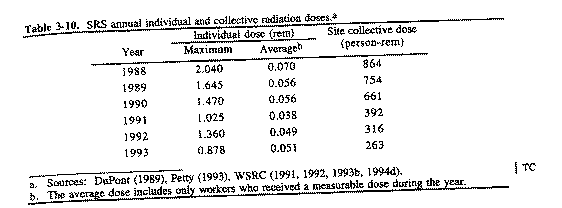
One of the major goals of the SRS Health Protection Program is to
keep worker exposures to radiation and radioactive material as
low as reasonably achievable (ALARA).  An effective ALARA program
must balance minimizing individual worker doses with minimizing
the collective dose of all workers in a given group.
The purpose of an as-low-as-reasonably-achievable program is to
minimize doses from both external and internal exposure.  Such a
program must evaluate both doses with the goal to minimize the
total effective dose equivalent.  ALARA evaluations must consider
individual and group collective doses to ensure the minimization
of both.  (Using many workers to perform extremely small portions
of a task would reduce the individual worker doses to very low
levels.  However, the frequent worker changes would make the work
inefficient, with the result that the total dose received by
all the workers would be significantly higher than if fewer workers
received slightly higher individual doses.)
SRS worker doses have typically been well below DOE worker
exposure limits.  DOE has set administrative exposure guidelines
at a fraction of the exposure limits to help enforce doses that
are as low as reasonably achievable.  For example, the current
DOE worker exposure limit is 5 rem per year, and the 1993 SRS
administrative exposure guideline was 1.5 rem per year.
Table 3-10 lists the maximum and average individual doses and the
SRS collective doses from 1988 to 1993.
Workers exposed to radiation have an additional risk of
contracting a fatal cancer of 0.04 percent per person-rem (NCRP
1993).  In 1993, 5,157 SRS workers received a measurable dose of
radiation.  Statistically, these workers should contract
approximately 1,200 fatal cancers from all causes during their
lifetimes; however, this cancer incidence rate depends on the age
and sex distribution of the population.  In 1993 this group
received 263 person-rem and could experience as many as
0.1 additional cancer death due to their 1993 occupational
radiation exposure.  Continuing operation
  Table 3-10.  SRS annual individual and collective radiation
              doses.a
of SRS could result in as many as 0.1 additional cancer death for
each year of operation, assuming future annual worker exposures
continue at the 1993 level.
3.5.4 WORKER NONRADIOLOGICAL HEALTH AND SAFETY
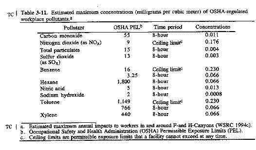
Industrial hygiene and occupational health programs deal with all
aspects of a worker's health and  relationship with the work
environment.  The basic objective of an effective occupational
health program is to protect employees against health hazards in
their work environment.  To evaluate these hazards, routine
monitoring determines employee exposure levels to hazardous
chemicals.  Exposure limit values are the basis of most
occupational health codes and standards.  If an overexposure to
a harmful agent does not exist, that agent generally does not
create a health problem.
The Occupational Safety and Health Administration (OSHA) has
established Permissible Exposure Limits (PELs) to regulate worker
exposure to hazardous chemicals.  These exposure limits refer to
airborne concentrations of substances and represent conditions
under which nearly all workers could receive repeated exposures
day after day without adverse health effects.
Table 3-11 lists the estimated maximum annual concentrations of
existing OSHA-regulated workplace pollutants modeled in and
around the F- and H-Canyons.  These nonradiological
concentrations are associated with the continued maintenance and
storage of plutonium solutions as well as other nuclear materials
and, with the exception of nitric acid and nitrogen dioxide (as
NOx), should not change from current levels.  Section 4.1.2 describes
the incremental impacts for nitric acid and NOx.  Estimated concentration
levels for existing OSHA-regulated workplace pollutants are
  Table 3-11.  Estimated maximum concentrations (milligrams per
             cubic meter) of OSHA-regulated workplace pollutants.a
less than 1 percent of the OSHA Permissible Exposure Limits, with
the exception of benzene, which is 2 percent of the OSHA limit
averaged over 8 hours.
DOE has established industrial hygiene and occupational health
programs for the processes covered by this eis and across the SRS
to protect the health of workers from nonradiological hazards.
|
NEWSLETTER
|
| Join the GlobalSecurity.org mailing list |
|
|
|