

Kerala - Geography
 Kerala is a small strip of land lying at the south-west corner of India, wedged between the Arabian Sea and the Western Ghats. Kerala is located between latitudes, 8°17'30"N and 12°47'40"N and longitudes, 74°27'47"E and 77°37'12"E. It has an area of 38,863 sq.km. Kerala is well within the humid equatorial tropics. Kerala's coast runs for some 580 km (360 miles), while the state itself varies between 35 and 120 km (22-75 miles) in width.
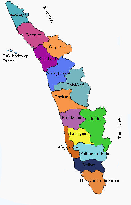
Kerala is one of the small states of India in terms of area. it consists of only 1.3 per cent of the total area of India. The state is located in the southwest corner of India. Karnataka and Tamil Nadu bound it on north, east and south and on east by the Arabian Sea. Physiographically, the state may be divided into three regions, Highlands, Midlands and Lowlands.
Kerala state is a narrow stretch of land along a sun-drenched coastline, bordering Lakshadeep Sea on the western side and Tamilnadu and Karnataka in the east. The length of the state from north to south is 560 km.
In between the high western ghats and the Arabian sea, the width of the State varies from 35 km to 120 km. There are extensive backwaters, lagoons, and coconut trees in the lowland area. The midland area are watered by numerous streams and where the presence of rice-fields, arecanut and coconut trees continues to dominate the landscape. The third natural part, the highlands of western ghats consists deep ravines and thick jungles. Thus Kerala is a narrow stretch of green land.
Kerala is a land that lies between the high hill ranges of the Sahyadris in the east and the Arabian Sea (Lakshadweep Sea) in the west. Kerala, gifted with mountains, valleys, trees, a wide variety of plants and grasslands has a share of just 1.2% of the total area of India. This region, with a varying topography, fertile soil and an ideal climate has been an abode of man from time immemorial.
Kerala is divided into three geographical regions: Highlands, which slope down from the Western Ghats onto the Midlands of undulating hills and valleys into an unbroken 580 km long coastline with many picturesque backwaters, interconnected with canals and rivers. The wild lands are covered with dense forests, while other regions lie under tea and coffee plantations or other forms of cultivation. Most of the state is engulfed in rich greenery which ensures a very calming experience at all times.
Kerala is home to a number of spectacular beaches. As Kerala is a coastal state, some of the most popular tourist destinations in Kerala are beaches like Kovalam, Varkala, Chowara, Chavakkad, Nattika, Cherai, Kizhunna, Poovar and the list goes on and on. The Kerala coast is replete with exotic resorts and hotels where travellers can spend their time sunbathing, swimming or simply enjoying the stunning view. The scenic backwaters of Kerala comprise serene stretches of lakes, canals and lagoons located parallel to the coast of the Arabian Sea. The backwater regions of Kerala are one of the most popular tourist destinations in the world. The tranquil backwater cruises are a once in a lifetime experience. Alappuzha, known as the 'Venice of the East', is especially popular for its houseboat cruises which soak in nature at its finest form.
Kerala brings a magical tryst with nature through its various hills and hill stations. A majority of these places in Kerala are situated on the windward side of the majestic Western Ghats. Enjoy the long chain of lush mist-clad hill stations of Kerala and explore the various plantations, wildlife, flora and fauna that comprise an integral part of this experience.
Kerala is rich in rivers and backwaters. 44 rivers (41 west flowing and 3 east flowing) cut across Kerala with their innumerable tributaries and benches. Three tributaries of the river Cauvery originate in Kerala and flow eastward. These rivers and streams flowing down from the Western Ghats either empty themselves in to the backwaters in the coastal area or directly into the Arabian Sea. Major rivers are Valapattanam river, Chaliar, Kadalundipuzha, Bharathapuzha, Chalakudy river, Periyar, Pamba, Achancoil and Kalladayar. Most of these rivers are navigable up to the midland region for country craft which provide a cheap and reliable transport system.
The backwaters form a specially attractive and economically valuable feature of Kerala. They include lakes and ocean inlets which stretch irregularly along the coast. The biggest backwater is the Veembandh lake. In area, which opens out into the Arabian Sea at Cochin Port. Other important lakes are AnjuThengu, Edava, Nadayaram Paravoor, Ashtamudi (Quilon), Kayamkulam, Kodungallor, (Cranganore) and Cheruva. Canals link the lakes and backwaters to facilitate an uninterrupted inland water navigation system.
All rivers in Kerala are rainfed. Although they are perennial, they become lean in summer. In Kerala about 78041 cubic meters of water is lost annually through rivers in the form of run off. Out of this only about 10300 cubic meters form part of the sub-surface water,i.e., less than 14%. Red soil, Laterite soil, coastal alluvium soil, Riverine alluvium, forest soils and black soil are the types of soil in Kerala. Laterite soil covers an area of about 68% of the total area of the state.
Located at the extreme southern tip of the Indian subcontinent, Kerala lies near the centre of the Indian tectonic plate; as such, most of the state is subject to comparatively little seismic and volcanic activity. Pre-Cambrian and Pleistocene geological formations compose the bulk of Kerala 's terrain.
Eastern Kerala consists of high mountains, gorges and deep-cut valleys immediately west of the Western Ghats' rain shadow. Forty one of Kerala 's west-flowing rivers, and three of its east-flowing ones originate in this region. The Western Ghats form a wall of mountains interrupted only near Palakkad, where the Palakkad Gap breaks through to provide access to the rest of India. The Western Ghats rises on average to 1,500 m (4920 ft) above sea level, while the highest peaks may reach to 2,500 m (8200 ft). Just west of the mountains lie the midland plains comprising central Kerala , dominated by rolling hills and valleys. Generally ranging between elevations of 250-1,000 m (820-3300 ft), the eastern portions of the Nilgiri and Palni Hills include such formations as Agastyamalai and Anamalai.
Kerala 's western coastal belt is relatively flat, and is criss-crossed by a network of interconnected brackish canals, lakes, estuaries, and rivers known as the Kerala Backwaters. Lake Vembanad- Kerala 's largest body of water-dominates the Backwaters; it lies between Alappuzha and Kochi and is more than 200 km² in area. Around 8% of India's waterways (measured by length) are found in Kerala . The most important of Kerala 's forty four rivers include the Periyar (244 km), the Bharathapuzha (209 km), the Pamba (176 km), the Chaliyar (169 km), the Kadalundipuzha (130 km) and the Achankovil (128 km). The average length of the rivers of Kerala is 64 km. Most of the remainder are small and entirely fed by monsoon rains.These conditions result in the nearly year-round water logging of such western regions as Kuttanad, 500 km² of which lies below sea level. As Kerala 's rivers are small and lack deltas, they are more prone to environmental factors. Kerala 's rivers face many problems, including summer droughts, the building of large dams, sand mining, and pollution.


|
NEWSLETTER
|
| Join the GlobalSecurity.org mailing list |
|
|
|