


4.7 Coyote Spring Valley
Information concerning the physical characteristics of the Coyote Spring Valley (Figure 4-61 ) is available from a number of sources. The Clark County Department of Comprehensive Planning and the U.S. Bureau of Land Management have compiled data on the soils and their erosion potential, biota, and habitat. The Nevada Bureau of Mines and Geology has published information on the geology and mineral resources of the valley, and the U.S. Geological Survey has published maps of the area and maintains databases on the water resources. The Nevada Division of Water Resources maintains a database on water resource use and availability and wells within the basin. The state of Nevada has information on air and water quality. The National Oceanographic and Atmospheric Administration keeps comprehensive climate records for numerous National Weather Service Observing Sites in southern Nevada, including sites that are close to the Coyote Spring Valley. Figure 4-61. The Coyote Spring Valley and surrounding area
4.7.1 Land Use
The Coyote Spring Valley includes privately owned land and land administered by the U.S. Bureau of Land Management and the U.S. Fish and Wildlife Service. Most of the area located west of U. S. Highway 93 is within the Desert National Wildlife Range. Land in the Coyote Spring Valley is used for a limited number of activities as discussed in the following Land-Use Designations section. Also discussed in this section is the infrastructure related to the Coyote Spring Valley.
4.7.1.1Public Land Orders and Withdrawals.
This section is not applicable to the Coyote Spring Valley.
4.7.1.2 Land-Use Designations.
Appreciable areas of the Coyote Spring Valley have been designated by the U.S. Bureau of Land Management for special management (BLM, 1992). The U.S. Bureau of Land Management has designated a portion of east-central Coyote Spring Valley as part of the Arrow Canyon Special Recreation Management Area (BLM, 1993). This area will be managed for semiprivate recreation opportunities and the protection of cultural resources. The area between the wildlife range and U.S. Highway 93 includes portions of three Wilderness Study Areas: NV050-201, NV050-216, and NV050-217. Wilderness Study Area NV050-17 is located in northern-most Coyote Spring Valley and includes the southern Delamar Mountains. Wilderness Study Area NV050-156 is located on the east side of the valley and encompasses most of the Meadow Valley Mountains. Wilderness Study Area NV050-215 also occurs along the east side of the basin and includes the northern portions of the Arrow Canyon Range. The largest block of privately owned land is the Aerojet Project Area, located east of U.S. Highway 93 between the Rainbow Canyon Road on the north and U.S. Highway 168 on the south. A portion of this land was sold by Aerojet to the Wylie Corporation. The Aerojet Project Area has been classified into four land-use types: (1) the project area of2,760 acres; (2) a buffer area of 11,240 acres of low-density tortoise habitat; (3) a 17,885-acre conservation reserve of moderate to high tortoise density; and (4) a 10,735-acre power line corridor (Aerojet General, 1987). These areas are all located east of U.S. Highway 93, north of U.S. Highway 168, and west of the Arrow Canyon Range. The U.S. Bureau of Land Management has also proposed a utility corridor through portions of the Coyote Spring Valley. This corridor, to be 805 m (2,640 ft) wide, would be located east of the centerline of U.S. Highway 93 from the south end of the Aerojet designated corridor. This corridor would cross the Arrow Canyon Range and into the Dry Lake Valley area substations. Two small areas of privately owned land are located on the west side of U.S. Highway 93: the old Butler Ranch which has been abandoned, and a silica sand mining operation. These two tracts contain only about 80 acres.
4.7.1.3 Site-Support Activities.
The site support of the Coyote Spring Valley is limited to two transmission lines. There are no existing facilities for water, sewage or waste disposal, or communications. SERVICESServices discussed for the Coyote Spring Valley include law enforcement and security, fire protection, and health care. Law Enforcement and SecurityThe Coyote Spring Valley is not a secured or restricted area. Law enforcement is provided by the Lincoln County Sheriff’s Department. Fire ProtectionFire protection is provided by the U.S. Bureau of Land Management. Health CareNo health care services are currently available on the site. UTILITIESOne transmission line roughly parallels U.S. Highway 93 and extends the entire length of the valley. The other transmission line is located 3 to 5 km (2 to 3 mi) south of U.S. Highway 168 and extends as far west as U.S. Highway 93.
4.7.1.4 Airspace.
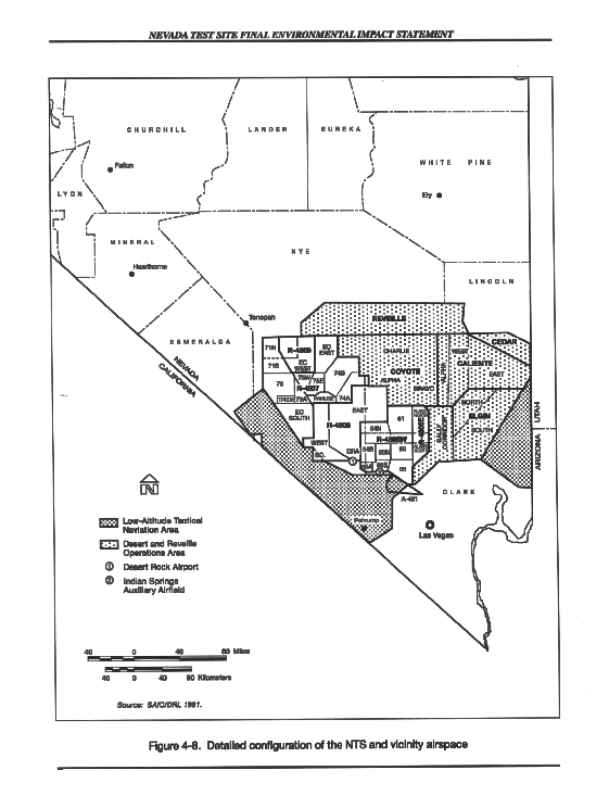
Airspace overlying almost all of the Coyote Spring Valley is the Sally Corridor portion of the Desert Military Operating Areas. Sally Corridor is used primarily as the transition route between Nellis Air Force Base and the NAFR Complex (see Figure 4-8 ).
4.7.2 Transportation
This section addresses on-site traffic, off-site traffic, transportation of materials and waste, and other transportation for the Coyote Spring Valley.
4.7.2.1 On-Site Traffic.
This section is not applicable to the Coyote Spring Valley.
4.7.2.2 Off-Site Traffic.
U.S. Highway 93, a two-lane, two-way rural highway, is the major regional access to the Coyote Spring Valley site. In 1993, U.S. Highway 93 had an average annual daily traffic of 1,210 vehicles and operated at a level of service B. U.S. Highway 168 provides access from the central part of the basin to the Muddy Springs Area and Moapa Valley to the east. Access via unpaved roads is also limited to two main routes, the Rainbow Canyon Road on the north and the Desert Wildlife Range Road on the west. There is no rail access to the Coyote Spring Valley.
4.7.2.3 Transportation of Materials and Waste.
This section is not applicable to the Coyote Spring Valley.
4.7.2.4 Other Transportation.
Air or rail transportation of workers or materials to the Coyote Spring Valley has not been proposed; therefore, these facilities have not been examined in detail.
4.7.3 Socioeconomics
The Coyote Spring Valley is located in Lincoln County. What follows is a discussion of general socioeconomic conditions in Lincoln County. The county’s land area is 2.7 x 10⁴ km² (10,635 mi²). The total civilian labor force in 1991 was 2,068; 4.5 percent or 94 civilians were unemployed. Some 6.8 percent were employed in agriculture; 1.7 percent in manufacturing; 18.7 percent in wholesale and retail trade; 2.0 percent in finance, insurance, and real estate; 5.0 percent in health services; and the largest sector, 16.0 percent inpublic administration. Total personal income for the county was $62.0 million, a 103.3-percent change from 1980 personal income. The 1992 population for Lincoln County was 3,739. It grew by 0.2 percent (less than 1 percent) between 1980 and 1992. Housing stock in the county totaled 1,800 with a vacancy rate of 26.4 percent. The number of houses increased by 6.8 percent between 1980 and 1990. The construction of four homes was authorized by building permits between 1990 and 1992. Of the total students in Lincoln County (1,066), 97.7 percent are enrolled in public elementary or high school. From 1986 to 1987, general revenue for the county was $7.2 million. Intergovernmental revenue was $5.6 million, and taxes accounted for $0.9 million, 95.8 percent of which was property taxes. Direct general expenditures were 7.6 million, a 21.5-percent change from 1982 to 1987.
4.7.4 Geology and Soils
Physiography, geology, and soils are addressed in this section. Also briefly discussed are seismic activities and geologic resources.
4.7.4.1 Physiography.
The Coyote Spring Valley is a topographically open basin comprised of about 1,702 km2 (657 mi 2). Elevations within the basin range from about 3,018 m (9,900 ft) on the west in the Sheep Range to about 650 m (2,134 ft) at the outlet for the valley along the Pahranagat Wash. The Arrow Canyon Range on the southeast rises to an elevation of only about 1,586 m (5,203 ft). On the southwest, the Coyote Spring Valley is separated from the Las Vegas Valley by the Las Vegas Range, with a maximum elevation of about 1,503 m (4,931 ft). On the valley floor, the major features are the many washes that drain the bounding upland areas and the broad alluvial fans and the Pahranagat Wash, an incised ephemeral stream. Badland topography occurs where the Muddy Creek Formation is exposed in the east-central part of the basin.
4.7.4.2 Geology.
The general geologic conditions and mineral deposits of the Coyote Spring Valley have been detailed by the Nevada Bureau of Mines and Geology (Longwell et al., 1965). The generalgeology of the valley comprises four major geologic units: alluvium, Tertiary valley-fill deposits, Tertiary volcanics, and Paleozoic carbonate rocks. The alluvium occurs over the valley floor and comprises interbedded gravels, sand, silt, and clay. The maximum thickness of alluvium is not known, but thicknesses of 183 to 260 m (600 to 850 ft) have been penetrated by U.S. Geological Survey and U.S. Air Force test wells. The Tertiary valley-fill deposits include the Muddy Creek Formation, which was deposited over a large area of Clark County. These deposits outcrop to the east of the Pahranagat Wash in the east-central part of the basin. The Muddy Creek Formation comprises a sequence of interbedded fine-grained and coarse-grained sediments, including claystone, siltstone, and minor sandstone. Gypsum is common in the more fine-grained deposits, and a conglomerate is common along the margins of the depositional basin. The thickness of the Muddy Creek Formation in the Coyote Spring Valley is not known, but is probably at least several hundred feet in most areas. The Tertiary volcanic rocks outcrop in the northern part of the Coyote Spring Valley and include tuffs and other volcanoclastic deposits with an unknown total thickness. The Paleozoic rocks of the Arrow Canyon, Sheep, and Las Vegas Ranges comprise a thick sequence of limestone, dolomites, and quartzite that include, in descending order, the Birdspring Formation, Monte Cristo Limestone, Sultan Limestone, Lone Mountain Dolomite, the Ely Springs Dolomite, the Eureka Quartzite, the Pogonip Group, middle and lower Cambrian Limestones and Dolomites, and the Chisolm and Pioche Shale. These rocks outcrop in the mountainous areas and probably underlie the Muddy Creek Formation at depth under the valley floor area. A number of major geologic structures occur in the Coyote Spring Valley. The Arrow Canyon syncline is a structural trough that occurs along the eastern Arrow Canyon Range in the northern part of the basin. On the western part of the basin, in the Sheep Range, the lower clastic aquitard (formed by the Cambrian clastics) has been thrust over younger Paleozoic rocks. The other predominant structural features are an east-west trending lineament through the Muddy Springs area, which may be related tothe Pahranagat Shear System, and a northeast-southwest trending lineament that extends from northeast the Coyote Spring Valley through Kane Spring Valley. MINERAL RESOURCESPotential mineral resources in the Coyote Spring Valley include fluid minerals (oil, gas, and geothermal resources), non-energy leasable minerals (primarily sodium and potassium compounds), salable minerals (common sand, gravel, and rock), and locatable minerals (nonmetallic mineral deposits) (BLM, 1992). Maps presented for the other off-site Solar Enterprise Zone facility alternative locations that show the resource potential are not available for the Coyote Spring Valley. Metallic mineral deposits are absent in the Coyote Spring Valley. The only known mineral deposits include a bentonitic clay deposit and sand and gravel. There are numerous placer claims within the basin. Oil and gas resources are considered speculative. The Nevada Department of Transportation has three material site rights-of-way within the basin. The geothermal resources are moderate. The U.S. Bureau of Land Management has categorized the sodium and potassium potential of the Coyote Spring Valley as moderate.
4.7.4.3 Soils.
The soils in the Coyote Spring Valley are typical desert soils (Entisols and Aridisols). The soils of the area have been categorized into seven soil types (Aerojet General, 1987). The Arizo soils form on alluvial fans with 2 to 8 percent slopes and are deep, excessively drained gravelly and cobbly sand. The permeability is very rapid, and the available water capacity is very low. The Badland soil unit forms on the Muddy Creek Formation and is stratified sand, silt, and clay with gypsum and calcium carbonate. The Badland soils are severely eroded and are unsuitable for development because of slope and erosion limitations. The Colorock-Tonopah Association forms on 2 to 8 percent slopes on alluvial fans and are gravelly sands or very gravelly loams. The Colorock soils are shallow loam over a caliche layer about 1 m (2 ft) thick and have a moderately rapid permeability and a very low available water capacity. The Tonopah soils are excessivelydrained and deep. The permeability is rapid, and the available water capacity is low. The Glendale fine sand is limited to floodplains and terraces with 0 to 2 percent slope. The Glendale grades downward from a fine sand to brown clay loam, silty loam, and very fine sandy loam. The permeability is very low, and the available water capacity is high. The Glendale loam occurs in similar areas, but is well drained and has a moderately slow permeability and high available water capacity. The Rockland-St. Thomas Association occurs on very steep slopes in the foothills and mountain sides. The Rockland is in areas of limestone exposures. The St. Thomas soils are cobbly loam that is well drained with a moderately rapid permeability and very low available water capacity. The Weiser cobbly sandy loam is a deep and well-drained soil that forms on steeper (15 to 30 percent slope) alluvial fans. The permeability is moderately rapid, and the available water capacity is low to very low. SOIL EROSIONThe soils in the Coyote Spring Valley are susceptible to erosion by wind and water. The potential for erosion is generally slight except where the soils have been disturbed or along the banks of washes. There is also the potential for localized landslides on the steep slopes of the upland areas. The soils that are most susceptible to erosion include the Badland soil and the Glendale fine sand (Aerojet General, 1987). The Badland soil has a very high water-erosion hazard, and headward erosion occurs extensively in this unit. The Glendale fine sand is very susceptible to wind erosion. The erosion hazard for the Arizo soils is slight; the erosion hazard for the other soils types present is moderate.
4.7.5 Hydrology
Discussions of hydrology are divided into surface water and groundwater. Water supply in the vicinity is also discussed.
4.7.5.1 Surface Hydrology.
There are no perennial surface water bodies or streams in theCoyote Spring Valley (Eakin, 1964). The surface water resources are meager, occurring only as ephemeral flow in the streambeds that drain the upland areas or in temporary ponding of runoff in the playa. Surface water flows into the basin on the north via the Pahranagat Wash (shown as White River or Muddy River on some maps). Because of the presence of surface water reservoirs in southern Pahranagat Valley, little if any runoff enters the Coyote Spring Valley from the north. To the northeast, the Kane Springs Wash discharges very infrequently to the Coyote Spring Valley. Surface water discharges from the Coyote Spring Valley into the upper Muddy Springs area through the Pahranagat Wash. Although there are no gaging stations within the basin, the U.S. Geological Survey does maintain a gaging station in the Pahranagat Wash in Arrow Canyon, just east of the basin boundary. Flow in the wash occurs very infrequently, usually for only a few days during the winter and late summer months. In some years of record, no flow occurred at all at this gaging station. For the 5 year period of record, the average annual runoff is 668,547 m3/yr (542 acre-feet/year). The peak instantaneous discharge rate of 95 m3/sec (3,350 ft3/sec) occurred on September 6, 1991. Flooding is probably a recurrent problem over most of the valley floor area in the Coyote Spring Valley. Severe flash floods do occur infrequently in both the Pahranagat Wash and Kane Spring Wash. Such floods typically occur when the tributary alluvial channels exceed bankful conditions, resulting in sheet flow over large areas on the alluvial fans that drain to the Pahranagat Wash.
4.7.5.2 Groundwater.
The Coyote Spring Valley is situated within the White River Flow System, a subsystem of the regional Colorado Flow System (Harrill et al., 1988). Groundwater that originates as precipitation over the upland areas of the valley discharges out of the regional flow system near Overton, 29 km (18 mi) to the east, ultimately reaching the Colorado River through a complicated pathway of groundwater and surface water flow. Groundwater under the Coyote Spring Valley occurs at depths ranging from only 3 m (10 ft) below land surface in a perched aquifer in the vicinity of the Coyote Spring and the old ButlerRanch to about 107 to 183m (350 to 600 ft) below land surface for the water table aquifer throughout the valley floor area (Buqo et al., 1992). Groundwater is derived from two sources: recharge over the basin (estimated at about 2.5 x 10⁶ m3/yr [2,000 acre-feet/year]) and subsurface inflow on the north from the Pahranagat Valley (about 4.3 x 10⁷ m3/yr [35,000 acre-feet/year]). Groundwater is discharged via subsurface outflow to the Muddy Springs area and is appreciable, estimated to be at least 4.6 x 10⁴ m3/yr (37,000 acre-feet/year). There are a number of springs in the Coyote Spring Valley (Eakin, 1964). The springs are situated primarily on the eastern slopes of the Sheep Range. Of the nine springs that have been identified, discharge data are only available for two, Coyote and Mormon Well Springs. Published estimates of discharge for both of these springs is less than 4 L/min (1 gal/min); however, some seasonal variations may occur with higher discharge rates in the late spring and reduced discharges during the summer and fall. As of 1992, there were 15 surface water rights totaling only 50,573 m3/yr (41 acre-feet/year) for springs in the basin. Because of the limited spring discharge and the irregular nature of surface water discharge, the only reliable water resource is groundwater. There is currently only one operating water supply well in the Coyote Spring Valley. Well yields within the basin are quite variable, depending on the aquifer that is used as a water source. In general, well yields from the alluvial aquifer are quite low, approximately a few hundreds of liters (a few tens of gallons per minute), owing to the limited saturated thickness of alluvium that is present over much of the basin. In contrast, exploratory water wells drilled into the underlying regional carbonate aquifer by the U.S. Air Force were found to be quite productive, with one well capable of producing more than 11,356 L/min (3,000 gal/min). Because of the tremendous water production potential of the regional carbonate aquifer, there has been considerable interest in developing water supplies in the Coyote Spring Valley in support of defense, municipal, and industrial applications. As of 1994, there were no groundwater rights appropriated within the basin (Buqo, 1996b). However, there are many senior applications for groundwater appropriations in the basin. In 1983, Nevada Power Company applied for 1.6 m³/sec (55.0 ft³sec). In 1985, Aerojet applied for 0.17 m³/sec (6 ft³/sec), and, later in that year, Nevada Power Company submitted applications for an additional 1.4 m³/sec (50 ft³/sec). In 1986, Aerojet filed 13 additional applications, bringing its total request to 747.97 m³/sec (26,414 ft³/sec). In 1988, a single application for 0.44 m³/sec (15.46 ft³/sec) was filed for ore processing and, in 1989, the Las Vegas Valley Water District filed five applications totaling 1.1 m³/sec (38 ft³/sec). None of these applications have been acted on, and there is considerable uncertainty regarding the potential for obtaining approval of new applications for groundwater to support a Solar Enterprise Zone facility. WATER QUALITYAccording to information published by the Las Vegas Valley Water District (Buqo et al., 1992), the groundwater in the Coyote Spring Valley is generally a calcium-sodium-sulfate type with a total dissolved solids concentrations ranging from 700 to 1,000 mg/L (700 to 1,000 ppm), exceeding the Primary Drinking Water standard of 500 mg/L (500 ppm). Samples of water from the alluvium have been found to have concentrations of iron and manganese that exceed drinking water standards, and elevated concentrations of fluoride have been reported for wells completed in the carbonate aquifer.
4.7.6 Biological Resources
Extensive inventories and assessments of the biological resources of the Coyote Spring Valley have been performed as part of the U.S. Air Force's MX Missile studies and as part of the Aerojet land withdrawal. Detailed information on the biological resources of the basin can be found in (Aerojet General, 1987), and is summarized in the following discussion. The scientific name of plants and animals mentioned in this section is given in Section E.2.6 , of Appendix E, Biological Resources. If the Coyote Spring Valley is selected as the most reasonable alternative location, updated surveys would be conducted in support of a Solar Enterprise Zone-specific environmental document. The plant communities of the Coyote Spring Valley are typical of those found in this part of the Mojave Desert. The dominant plants include creosote bush and white bursage. Mojave yucca, beaver tail cactus, and spiny menodora are subdominant on the bajada areas; shadscale, prince's plume, and wolfberry are subdominant over badland areas; desert willow and cheesebush are subdominant in wash areas. There are no known federally listed threatened, endangered, or candidate plant species within the area designated for consideration as a Solar Enterprise Zone facility. The desert tortoise is the only threatened or endangered animal species in the Coyote Spring Valley. The Coyote Spring Valley is within critical habitat for this species. The U.S. Bureau of Land Management has designated a large area of the basin as an Area of Critical Environmental Concern to provide for management of the desert tortoise population in accordance with the U.S. Fish and Wildlife Recovery Plan for the desert tortoise (Mojave Population). The tortoise density of the Coyote Spring Valley ranges from 65 to 194 per km² (25 to 75 per mi²) with a total population of almost 18,000, according to the U.S. Bureau of Land Management. Detailed investigations by Garcia et al., 1982 indicate that the population in the vicinity of the proposed Solar Enterprise Zone facility location ranges from 26 to 233 per km² (10 to 90 per mi²). Because of the relatively high density of tortoises and the pristine habitat conditions, the Coyote Spring Valley is considered one of the most valuable tortoise habitats in Nevada (Aerojet General, 1987). The desert bighorn sheep is a trophy big game species that has been classified as a sensitive species for management purposes by the U.S. Bureau of Land Management and Nevada Department of Wildlife. Bighorn sheep inhabit all of the mountain ranges surrounding the Coyote Spring Valley, and five intermountain migration routes have been identified. One route is 16 km (10 mi) northeast of a Solar Enterprise Zone facility site between the Delamar Mountains and northern Meadow Valley Mountains, and another route is located 10 km (6 mi) to the southeast between the Arrow Canyon Range and the southern Meadow Valley Mountains. Although undocumented and unsighted within the Coyote Spring Valley, the banded gila monster, a State-protected reptile, may be present. This animal has been reported in the Maynard Lake area immediately north of the Coyote Spring Valley and to the east in the Moapa Valley. The most suitable gila monster habitat in the vicinity of the alternative Solar Enterprise Zone location is in the rocky areas of Pahranagat Wash and adjacent arroyos. If present within the Coyote Spring Valley, the density of this species is expected to be quite low.
4.7.7 Air Quality and Climate
This section includes a description of the air quality conditions at the Coyote Spring Valley, including climatology, meteorology, and ambient air quality. CLIMATOLOGY AND METEOROLOGYAlthough there are no weather stations in the Coyote Spring Valley, National Oceanic and Atmospheric Administration data on the climate of the area are available for stations located in the Valley of Fire, Logandale, and North Las Vegas. In general, the climate of the valley exhibits the low humidity and low annual precipitation characteristic of the climate of Clark County. The warmest month is July, when the mean monthly maximum temperature is 40 °C (104 °F); January is the coolest month, with a mean monthly minimum of 0°C (32 oF). The average monthly wind speed ranges from 11 kph (7 mph) in December to 18 kph (11 mph) in April and June. Diurnal variation in wind is common, reflecting the differential heating of the ground. AMBIENT AIR QUALITYThe Coyote Spring Valley is located within Nevada Intrastate Air Quality Control Region 147, which is designated unclassifiable/attainment for all criteria pollutants. The closest Class I Prevention of Significant Deterioration area is the Grand Canyon National Park, approximately 121 km (75 mi) southeast of the Coyote Spring Valley. Because the Coyote Spring Valley is largely undeveloped, there are few emission sources in the area. Typical sources include a silica sand mining operation in the north-central part of the basin; on-road and off-road vehicle, railroad, and aircraft traffic; and fugitive dust.
4.7.8 Noise
The acoustic environment of the Coyote Spring Valley can be classified as uninhabited desert or small rural communities (Section 4.1.8 ). Noise measurements have not been made at the Coyote Spring Valley Solar Enterprise Zone site. Natural sources include wind and thunder. The major sources of noise would be associated with prevailing meteorological conditions, such as wind.
4.7.9 Visual Resources
The landscape character of the Coyote Spring Valley is typical of the Great Basin with extensive views of linear mountain ranges and valleys arranged in a north-south orientation. The valley is surrounded to the southwest and west by the Las Vegas and Sheep Ranges, Delamar Mountains to the north, Meadow Valley Mountains to the east, and Arrow Canyon Range to the south. The steep and rugged mountain slopes give way in the valley to gently sloping surfaces dissected by arroyos and washes. The visual quality of the area ranges from Class B to Class C. Because of the surrounding vista, the visual quality of the site has been designated ClassB. The proposed Solar Enterprise Zone facility in the Coyote Spring Valley is visible to the east from U.S. Highway 93. State Route 168 is 19 km (12 mi) south of the proposed site. The site would be visible from BLM Wilderness Study Areas located in the Delamar Mountains, Meadow Valley Mountains, and along the west side of U.S. Highway 93. The BLM Wilderness Study Areas range from 2 km (1 mi) to 8 km (5 mi) from the site. There are two utility corridors that roughly parallel these two routes. An abandoned ranch is located in the northern portion of the valley, and there is an active silica sand mining operation located adjacent to this ranch. The Kane Spring Wash cuts from east to west in the north part of the site.
4.7.10 Cultural Resources
The Coyote Spring Valley lies in southern Nevada, an area with a prehistory that may span the past 10,000 years or more. Properties ranging from the early prehistoric period to historic mining and ranching sites are known. A summary of culturalresources and associated impacts are described in (Aerojet General, 1987). SITES OF AMERICAN INDIAN SIGNIFICANCECoyote Spring is an area on the west flank of the Meadow Valley Mountains. The CGTO knows that this site contains a wide variety of American Indian cultural resources. The site was studied by American Indian people during the Intermountain Power Project (Stoffle and Dobyns, 1982). Nine Indian-use plants were identified during that on-site visit, including desert willow (Chilopsis linearis), prince’s plume (Stanleya pinnata), and wolfberry (Lycium andersonii) (Stoffle and Dobyns 1982). The large desert tortoise was observed at this location. The area contains portions of an original Indian trail-wagon road from the Moapa Valley to Pahranagat Valley. Archaeological survey of the Intermountain Power Project corridor revealed 9 sites and 20 scattered finds (Tucker et al., 1982). Known American Indian cultural resources exist in the Coyote Spring area, but it is impossible to fully understand the potential impacts to cultural resources without additional systematic on-site resource studies by American Indian people.
4.7.11 Occupational and Public Health and Safety
The Coyote Spring Valley location proposed for siting a Solar Enterprise Zone facility is currently undeveloped desert. Baseline health and safety considerations associated with the environment include potential for heat stroke and exhaustion (primarily during summer months), dehydration, and poisonous spider and snake bites. Other physical hazards include tripping or stumbling hazards associated with the desert terrain.
4.7.12 Environmental Justice
Existing demographic conditions for Environmental Justice are discussed in Section 4.1.12 . This discussion includes conditions for the Coyote Spring Valley.
|
NEWSLETTER
|
| Join the GlobalSecurity.org mailing list |
|
|
|