


I.7.0 LAND USE
While the focus in the following land-use section is on the 200 Areas, a brief summary is provided on land uses for the remainder of the Hanford Site as well as surrounding offsite land-use patterns. Also addressed are the future planning efforts of other Federal and State agencies, Tribes, and local governments. Prime and unique farmlands and recreational opportunities also are identified.
I.7.1 PRIME AND UNIQUE FARMLAND
The Farmland Protection Policy Act requires Federal agencies to consider prime or unique farmlands when planning major projects and programs on Federal lands. Federal agencies are required to use prime and unique farmland criteria developed by the U.S. Department of Agriculture's Soil Conservation Service (SCS). Under Farmland Protection Policy Act, the SCS is authorized to maintain an inventory of prime and unique farmlands in the United States to identify the location and extent of rural lands important in the production of food, fiber, forage, and oilseed crops (7 CFR Part 657). The SCS has determined that because of low annual precipitation in southeast Washington State, none of the soil occurring on the Hanford Site would meet prime and unique farmland criteria unless irrigated (Brincken 1994). The specific location of potential irrigable prime or unique farmlands at the Hanford Site has not been determined by the SCS because of the absence of detailed slope information.
I.7.2 EXISTING LAND-USE TYPES AND LAND-USE PLANS
This section discusses 1) existing Site land uses and associated issues based on the Hanford Site Development Plan (HSDP); 2) the Comprehensive Land Use Plan (CLUP) for the Site that was prepared by DOE and released for public comment in August 1996 (DOE 1996c) , and other relevant land-use plans by Federal, State, and local agencies and Tribal Nations; and 3) recreational uses.
I.7.2.1 Hanford Site Development Plan
The HSDP provides an overview of land use, infrastructure, and facility requirements to support DOE at the Hanford Site (DOE 1993e). Although the HSDP is not a formal land use plan, it is the most current available planning document until the Site's CLUP is finalized . DOE has invited Trib al Nations , county and city governments, and other stakeholders to participate in the planning process. A draft of the CLUP was release d for public comment in August 1996. Because the CLUP is not yet final , the following discussion focuses on the HSDP.
The HSDP has a Master Plan section that outlines the future land and the infrastructure needed by Hanford Site missions. The primary objective of the Master Plan has been to develop and maintain the Hanford Site infrastructure to meet ongoing and future program requirements (DOE 1993e). A goal of the HSDP has been to maximize the amount of land available for other beneficial uses, including protecting cultural and biological resources.
The HSDP provides for a compatible land-use transition from offsite agricultural uses in Adams, Grant, Franklin, and Benton counties to passive uses onsite in the FEALE Reserve and the proposed National Wildlife Refuge north of and along the Columbia River. The areas of the Hanford Site nearest to the river are proposed to remain undeveloped, providing an additional buffer area between sensitive natural areas and more intensely developed areas such as the Central Plateau. The HSDP accommodates future intensive uses, such as industrial development and research in the southeast area of the Hanford Site near the urban development of Richland. These more intensive uses are adequately separated from less intensive agricultural uses in Franklin County by the Columbia River. The future land uses are designed to facilitate cleanup, maintain a stable employment and economic foundation, provide energy research and development, continue waste management and disposal activities, and provide environmental protection.
Figure I.7.2.1 identifies the existing land uses on the Hanford Site. The Hanford Site has seven major land-use types:
- Reactor Operations, which involves the development and irradiation of nuclear fuels, fuel fabrication, fuel storage, and reactor plant operations (all operations except storage are currently inactive);
- Waste Operations, which include the treatment, storage, and disposal of radioactive and nonradioactive waste, including waste treatment facility operations, active and inactive tank farms, burial grounds, vaults, and cribs;
- Operations Support, which involves services provided specifically for operations that are primarily industrial;
- Administrative Support, which provides administrative services for overall Hanford Site activities;
- Research and Development and Engineering Development, which includes basic and applied research conducted to advance fundamental scientific knowledge related to Hanford Site activities as well as other major national needs;
- Sensitive Areas, which include environmentally (ecological) or culturally (historical, archaeological, and religious) important areas; and
- Undeveloped Areas, which include areas that have not been developed or have been restored to an undeveloped state. The undeveloped areas also contain sensitive biological and cultural resources.
Figure I.7.2.1 Existing Land-Use Map
Sensitive Areas are the largest portion of the existing land use on the Hanford Site. These include the FEALE Reserve, an area that occupies the entire southwest portion of the Hanford Site. Also included are all the Hanford Site lands north of the Columbia River, lands along the river, Gable Butte, Gable Mountain, and an area along the eastern boundary of the Hanford Site south of the river. The area north of the river, the North Slope, is administered by two separate agencies. The U.S. Fish and Wildlife Service (USFWS) administers the area in Grant County west of the northern point of the Hanford Reach known as the Saddle Mountain National Wildlife Refuge. The Washington State Department of Fish and Wildlife Services administers the area in Grant, Adams, and Franklin counties to the north and east of the Hanford Reach, which is known as the Wahluke Wildlife Recreation Area. These areas are undeveloped, natural wildlife areas.
The FEALE Reserve and the North Slope are being considered by DOE for release. The release of the FEALE Reserve could involve land exchange agreements between DOE and the Bureau of Land Management (BLM). The Yakama Indian Nation also has proposed that they take ownership of the Reserve, as has Benton County. Current considerations for the North Slope involve the proposed National Park Service designation of the area as a National Wildlife Refuge (NWR) to be administered by the USFWS. Benton, Franklin, and Grant county commissioners oppose the proposed designation of the North Slope (Campbell 1995). No final resolution of either of these issues has occurred .
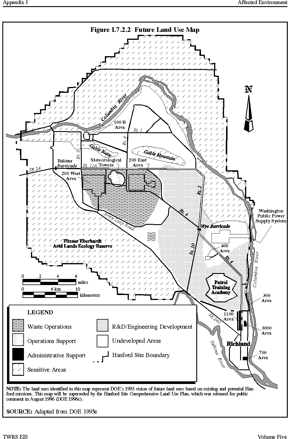
The HSDP contains a Future Land Use Map that presents DOE's 1993 vision of future Site land-use needs (Figure I.7.2.2). The Future Land Use Map was intended for annual updates to reflect mission changes, regulatory decision documents, NEPA documents such as the Hanford Remedial Action EIS and the TWRS EIS, and other appropriate sources (DOE 1993e). However, the Site CLUP, was release d in draft form in August 1996 with final decisions expected in early 1997, will provide an official DOE vision of future Site land uses (DOE 1996c) .
Figure I.7.2.2 Future Land-Use Map
As previously mentioned, a goal of the HSDP has been to maximize the amount of land available for other beneficial uses. Future land-use designations were also based on existing and potential Hanford Site missions and assumptions, and the recommendations of the Hanford Future Site Uses Working Group (HFSUWG 1992). The Reactor Operations, Sensitive Areas, and Administrative Support areas remain unchanged from the existing land-use plan (Figure I.7.2.2).
The Hanford Site consists of 1,450 km2 (560 mi2) or 145,000 ha (358,000 ac) of land. Of the total Hanford Site area, the Central Plateau, which has been identified for waste management operations, constitutes 117 km2 (45 mi2) or 11,700 ha (29,000 ac) of land. This represents approximately 8 percent of the total Hanford Site area. The Central Plateau would consist of 1) a buffer zone of 49 km2 (19 mi2) or 4,900 ha (12,000 ac); and 2) a waste management area of 26 km2(10 mi2) or 2,600 ha (6,400 ac). The buffer zone would separate the waste management activities from other areas of the Hanford Site. The 200 Areas would be contained entirely within the waste management area. The 200 Areas consists of 26 km2 (10 mi2) or 2,600 ha (6,400 ac) of land. This represents approximately 22 percent of the total Central Plateau waste management area and 2 percent of the total Hanford Site.
The Waste Operations area is primarily limited to the 200 Areas. Virtually all proposed TWRS activities except two potential borrow sites would occur in or between the 200 Areas. The 200 Areas have been used to process irradiated nuclear fuel and store the resulting waste. Existing facilities in this area include the PUREX Plant, the Plutonium Finishing Plant, the U Plant, the tank farms, the Central Waste Complex, and the Waste Sampling and Characterization Facility. The PUREX, Plutonium Finishing Plant, and U Plants are being deactivated (DOE 1993e). The 200 Areas are also used for Research and Development and Engineering Development; they also contain meteorological towers.
The future locations of the Waste Operations area remain the same although the overall Waste Operation area has been expanded. This expansion reflects land dedicated to a potential cleanup scenario where Sitewide waste is collected and placed in a central location dedicated to exclusive use as a waste disposal area. This includes relocating waste sites, contaminants, and associated structures such as the 100 Area facilities.
According to the HSDP, the future Operations Support areas will remain unchanged except for closing and reclaiming the borrow pit in the western portion of the Hanford Site. The Research and Development and Engineering Development area has increased substantially to include the majority of the southeastern portion of the Hanford Site. The Undeveloped Areas, which include areas of sensitive ecological and cultural resources, have been reduced in size to reflect the future release and reuse of portions of the Site. DOE is working with a variety of governmental and nongovernmental organizations to ensure protection, preservation, and proper management of Hanford Site ecological and cultural resources.
The National Park Service released a Final EIS in June 1994 that recommended designating the Hanford Reach portion of the Columbia River as a Recreational River under the Wild and Scenic Rivers Act and also proposed designating the North Slope, an upland area north and east of the river, a National Wildlife Refuge (NPS 1994). This proposal would transfer management of the river and a 0.40 km (0.25 mi) strip of land along both shores of the river to the USFWS along with approximately 41,300 ha (102,000 ac) of adjacent lands. Development restrictions are included for protecting cultural resources, threatened and endangered species, water quality, unique scenic geologic features, and Native American access and use. The Secretary of the U.S. Department of Interior has issued a Record of Decision indicating a preference for this proposal. This recommendation has been sent to Congress with the final EIS for consideration (NPS 1994).
Benton, Franklin, and Grant count y commissioners oppose the proposed U.S. Department of Interior recommendation and have offered an alternative approach that would leave the Reach under local government control (Stang 1996b). Various local groups (e.g., the Lower Columbia Basin Audubon Society) and many area residents support the Wild and Scenic Rivers designation. No final decisions have been made.
BLM owned many scattered tracts of land on the Hanford Site prior to transferring those lands to the Atomic Energy Commission for national security reasons in 1943. BLM currently does not own any lands on the Site's Central Plateau. However, BLM owns land that includes the potential Vernita Quarry borrow site.
I.7.2.2 Washington State
Washington State has several land interests onsite. The Washington State Department of Fish and Wildlife currently administers the area of the Hanford Site north and east of the Hanford Reach known as the Wahluke State Wildlife Recreation Area. This area is considered sensitive ecological upland habitat and is part of the Wahluke Slope. Washington State also leases a square parcel in the south-central portion of the Hanford Site between State Route 240 and the Route 2/Route 4 junction. This property is located within the undeveloped area of the Hanford Site.
I.7.2.3 Tribal Nations
The Hanford Site is located on land ceded from the Confederated Tribes and Bands of the Yakama Indian Nation and the Confederated Tribes of the Umatilla Indian Reservation (the Umatilla, Cayuse, and Walla Walla Tribes), based on treaties signed in 1855 (DOE 1992b). The Nez Perce Tribe has treaty rights on the Columbia River under a separate treaty.
I.7.2.4 Local Governments
The Hanford Site is located within portions of Benton, Franklin, Grant, and Adams counties. Other surrounding local jurisdictions include the cities of Richland, West Richland, Pasco, and Kennewick.
Because many of the local jurisdictions existing comprehensive plans are incomplete or outdated, they have been updated recently or are in the process of being updated as mandated by the 1990 Washington State Growth Management Act. Because of its limited recent growth, Adams County is not updating its plan.
The majority of the Hanford Site is located within Benton County and comprises up to 25 percent of the county land. The cities of Richland, West Richland, Kennewick, Prosser, and Benton City are located in Benton County. The unincorporated areas of the county adjacent to the Hanford Site currently have generalized land-use designations for rangeland and undeveloped and dry agriculture. Rangeland activities consist largely of cattle grazing. Undeveloped or vacant land is primarily open space. Dry agriculture, the largest single land use in the county, consists almost exclusively of dryland wheat and summer fallow (BCBCC 1985).
Benton County officials are concerned with the remediation and potential reuse of the Hanford Site because most of the land-use effects resulting from reuse would occur within Benton County. Benton County is in the process of updating its comprehensive plan. The county plan update will include a separate Hanford Comprehensive Plan that will be consistent with the overall county plan (Walker 1995). The County Planning Department has defined three categories of land use for the Site: 1) critical areas (e.g., wetlands, areas prone to landslides, fish and wildlife areas); 2) areas where development could occur only if damaged habitat was replaced or restored; and 3) areas where development could occur with minimal restrictions. Of the potential TWRS areas, the potential Vernita Quarry borrow site is within a defined critical area, and the potential McGee Ranch borrow site is within the land use category that would require replacement or restoration of affected land. The Washington State Department of Fish and Wildlife asked Benton County to designate the McGee Ranch as a critical area (preservation area) (McConnaughey 1996a). All other potential TWRS sites are within areas where only minimal development restrictions would be imposed (Fyall 1996).
Benton Countys proposed Hanford Comprehensive Plan is in the process of review and public hearings before the County Planning Commission and then before the county commissioners. The Hanford Comprehensive Plan is expected to be formally adopted by the end of 1996 (Fyall 1996).
Franklin County is located east of the Hanford Site and includes the city of Pasco. The unincorporated area of the county adjacent to the Hanford Site is rural and sparsely developed (Franklin County 1982). The land-use designation surrounding the Hanford Site, as with most of the county, is agricultural. Franklin County adopted an updated comprehensive plan in April 1995. The updated plan does not directly impact any land uses at the Hanford Site (German 1995).
Grant County is located north of the Hanford Reach and includes the Area of the Hanford Site north of the river. The land uses adjacent to the Hanford Site are designated as agricultural (Grant County 1994). This use type is restricted to crop agriculture, agricultural related industries, livestock, and public utility functions (Grant County 1988). Grant County is in the process of updating its comprehensive plan with an expected completion date in 1998 . However, no changes in the county plan would impact areas of the Hanford Site south and west of the Columbia River, which include all potential TWRS areas, because those areas are not within Grant County (Lambro 1996).
Adams County is located northeast of the Hanford Site although a small portion of the Site is located within Adams County. The land use adjacent to the Hanford Site within Adams County is designated as agricultural (Caputo 1994). These lands are either being used for rangeland or are lying fallow.
The city of Richland is located immediately adjacent to the Hanford Site. Richland is currently in the process of annexing the Site's 1100 Area (Milspa 1995). The existing land uses within Richland near the Hanford Site include industrial, agricultural, and public lands. The planned land use designation within the Richland area adjacent to the Site is identified as industrial (City of Richland 1988). Industrial use is compatible with the adjacent Site use. The city develop ed a set of alternatives for its updated comprehensive plan ; these alternatives were released for public review in March 1996 . The comprehensive plan itself is scheduled for adoption in early 1997 (Milspa 199 6 ). With respect to the Hanford Site, the Richland plan focuses only on the southern portions of the Site, which are within the city's 20-year growth boundaries. The various alternatives being considered for the updated plan would be expected to call for maintaining and expanding industrial and research and development activities in the areas of the city adjacent to the site (Milspa 1996).
West Richland is located to the south of the Hanford Site and is one of the closest developing residential communities. The West Richland land use near the Hanford Site is designated low-density residential (West Richland 1994). This use is consistent with the nearby existing uses (FEALE Reserve and Undeveloped Area) at the Hanford Site. The West Richland Comprehensive Plan update was released in June 1996 and is expected to be adopted in September 1996 . There is little in the update that would impact Hanford Site land-use issues (Corcoran 199 6 ).
Pasco is located southeast of the Hanford Site and includes the Tri-Cities Airport, which is the area's primary airport. Pasco has been planning major commercial, industrial, office, and residential improvements along the Interstate 182 corridor to attract future Hanford Site-related and other businesses (McDonald 1994). Pasco adopted its updated comprehensive plan in August 1995. However, very little in the update is related to Hanford Site land-use issues (McDonald 1995).
Kennewick is located south of the Hanford Site and is separated from the Site by the Yakima River and the city of Richland. Like Pasco, Kennewick has been planning additional industrial and office areas to attract new businesses. Kennewick adopted its updated comprehensive plan in April 1995. Very little in the updated plan is related to Hanford Site land uses (White 1995).
Another local agency that could be impacted by remediation and reuse of the Hanford Site is the Port of Mattawa. The Port of Mattawa is located in Grant County, northwest of the Hanford Site. The Port of Mattawa is a local government agency obligated to enhance the economic development within District No. 3 of Grant County (Connelly 1994). The Port of Mattawa supports the Wahluke 2000 Plan, which proposes, with U.S. Bureau of Reclamation assistance, to expand irrigated farming acreage and increase recreation uses while protecting wildlife habitat (Wahluke 1994). The Wahluke 2000 Plan represents a different approach than the one outlined by the Park Service (in the Hanford Reach EIS), which has proposed a Recreational River status under the Wild and Scenic Rivers Act for the Hanford Reach of the Columbia River.
I.7.2.5 Natural Resources Trustees Council
The Hanford Site Natural Resources Trustees Council is composed of representatives from the States of Washington and Oregon, Federal agencies (DOE and Interior), and three affected Tribal Nations (Yakama Indian Nation, CTUIR, and Nez Perce Tribe). The primary purpose of the Council is to facilitate the coordination and cooperation of the trustees in their efforts to restore and minimize impacts to natural resources injured as a result of or during cleanup of releases associated with DOEs activities at the Hanford Site. The Councils primary role with respect to the TWRS project will be to consult with DOE during development of the Mitigation Action Plan for impacts identified in the TWRS EIS.
I.7.3 RECREATIONAL RESOURCES AND THE NATIONAL ENVIRONMENTAL RESEARCH PARK
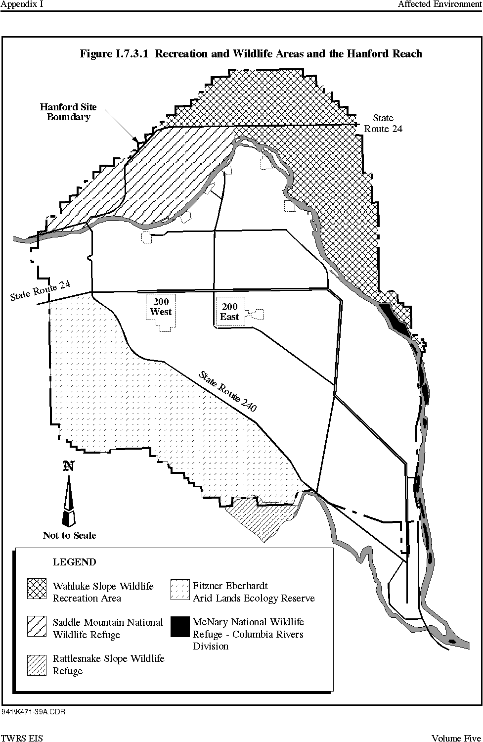
For the purposes of wildlife management and outdoor recreation, some portions of the Hanford Site are administered by agencies other than DOE. The entire Hanford Site was designated by DOE as a National Environmental Research Park in 1976 (NPS 1994). National Environmental Research Parks are aimed at original research into the ecology and natural sciences of an area. Nearly one-half of the Site is designated for use as wildlife management (Figure I.7.3.1). These wildlife management areas buffer developed areas of the Site. They are the FEALE Reserve, Saddle Mountain NWR, Wahluke Wildlife Recreation Area, Rattlesnake Slope Wildlife Area, and McNary NWR. Ecological data have been collected on these sites for more than 40 years.
I.7.3.1 Fitzner Eberhardt Arid Lands Ecology Reserve
The FEALE Reserve is located in the southwest corner of the Hanford Site. Currently, all research activities on the FEALE Reserve are funded by DOE. Consisting of 310 km2 (120 mi2) including Rattlesnake Mountain, the FEALE Reserve is managed for DOE by the Pacific Northwest National Laboratory.
BLM is also involved in the FEALE Reserve. In July 1993, BLM proposed exchanging sections of the Hanford Site with DOE for the FEALE Reserve. BLM propose d to continue management of the FEALE Reserve for its wildlife benefits and to designate it a National Conservation Area. The Yakama Indian Nation also proposed assuming control of the Reserve, with an emphasis on wildlife management, as well as use for Native American cultural purposes. In addition, Benton County has proposed taking over the FEALE Reserve (Stang 1996a).
In July 1996, DOE notified the Yakama Indian Nation, other Federal agencies, and Benton County of its decision to keep control of the Reserve (O'Leary 1996). The Reserve will continue to function as a buffer zone for ongoing waste management in the 200 Areas. DOE also announced its intention to negotiate an agreement with the U.S. Fish and Wildlife Service to manage the Reserve while protecting the ecologically sensitive area and allowing greater public access (Stang 1996c).
Figure I.7.3.1 Recreation and Wildlife Areas and the Hanford Reach
I.7.3.2 McNary National Wildlife Refuge
The McNary NWR, located near the confluence of the Columbia and Snake Rivers, includes three divisions: Burbank Slough, Strawberry Island, and Hanford Islands (Figure I.7.3.1). Only the Hanford Islands Division is within the boundaries of the Hanford Site. The Hanford Islands Division contains six islands in the Columbia River and is located upstream from the city of Richland.
The Hanford Islands extend a distance of 14.5 river km (9 river mi) and contain 140 ha (350 ac). The islands are closed to the public during waterfowl nesting season to protect breeding waterfowl, particularly aleutain canada geese, a Federal and State endangered species.
The McNary NWR was established in 1955 by a cooperative agreement with the U.S. Army Corp of Engineers, which transferred administrative control of nearly 1,200 ha (3,000 ac) of land to the USFWS. Additional acquisitions have enlarged the refuge to the present area of 1,300 ha (3,300 ac). Recreation activities include fishing, picnicking, swimming, and water skiing.
I.7.3.3 Saddle Mountain National Wildlife Refuge
The USFWS manages Saddle Mountain NWR, located on the Hanford Site north and west of the Columbia River (Figure I.7.3.1). Currently, the area is closed to all public use and is dedicated to wildlife management. The USFWS monitors the area for waterfowl populations, kestrel nesting activity, and raptor activity.
The Saddle Mountain NWR was established in 1971 by DOE through a joint agreement with the USFWS. The NWR is located north of the Columbia River from the center of the Hanford Reach to the western boundary of the Hanford Site. The area is currently controlled by DOE but will be transferred to the USFWS upon cleanup of its contaminated sites.
I.7.3.4 Wahluke Wildlife Recreation Area
The Washington State Department of Fish and Wildlife manages the Wahluke Wildlife Recreation Area, located on the Hanford Site north and east of the Columbia River (Figure I.7.2.1). The Wahluke Wildlife Recreation Area is open for public recreation. More than 41,000 people used the area and nearby facilities between July 1988 and July 1989, the most recent year for which statistics are available. More than half of this use took place at the Vernita boat launch, an unimproved launch area immediately upstream of the Vernita Bridge. The Washington State Department of Fish and Wildlife leases approximately 34 ha (85 ac) of Wahluke Wildlife Recreation Area to various private operations for agricultural sharecropping.
I.7.3.5 The Hanford Reach (Proposed Wild and Scenic River Designation)
As the last free-flowing segment of the Columbia River, the Hanford Reach has been proposed for Wild and Scenic River status. The Hanford Reach extends from river mile 396 downstream to river mile 345 and includes those portions of the Columbia River within the boundaries of the Hanford Site. The Hanford Reach boundaries include a 0.4-km (0.25-mi) strip of land on each side of the river, the Saddle Mountain NWR, and the Wahluke Wildlife Recreation Area (Figure I.7.3.1). Designation as a Recreational River (the least restrictive designation under the Wild and Scenic Rivers Act) would provide permanent protection for salmon and cultural resources, enhance wildlife habitats and populations, and improve access and natural resource interpretation for visitors. The USFWS would be designated as the administrating agency. All lands within the proposed boundary would be transferred to USFWS (NPS 1994).
Benton, Franklin, and Grant count y commissioners oppose designating the Hanford Reach as a Wild and Scenic River and have offered an alternative proposal that would provide for local government rather than federal control of the Reach (Stang 1996a). Other local residents support the Federal Wild and Scenic River designation. No final decisions have yet been made.
1.7.3.5.1 Recreational Use
The Hanford Reach and adjacent wildlife refuge and recreation areas provide a variety of recreational activities year-round for local residents and visitors. The most popular activities are sport fishing, boating, and waterfowl hunting, which are considered substantial in terms of impact on the local economy. Other popular activities include waterskiing, upland hunting, and nature observation. The heaviest use period occurs during September and October, coincident with runs of fall chinook salmon. Hunting occurs in areas downstream of the Hanford Townsite from mid-October until late January each year. Nature observation is most popular during autumn and winter months when the greatest number and diversity of migratory and wintering waterfowl species are present.
Because of restricted use of the Hanford Site and Saddle Mountain NWR lands, virtually all land-based recreation occurs on the Wahluke Wildlife Recreation Area. Water-based recreation is supplemented with boating that originates from areas downstream of the Hanford Site. However, the distance from Richland boat launches to key fishing and sightseeing locations suggests that boating accounts for less than 20 percent of water-based use within the Hanford Reach. Total current recreational use of the Hanford Reach comprises approximately 10,000 land-based visits by hunters, trappers, and nonconsumptive users and approximately 40,000 visits by water-based users (predominantly anglers) per year (NPS 1994).
I.7.3.5.2 Sport Fishing
The Hanford Reach is enjoyed by sport fisherman throughout the Pacific Northwest. Steelhead, sturgeon, and smallmouth bass are the primary sport fish. Of these species, the fall chinook salmon and steelhead are regionally important recreational resources, and the Hanford Reach is one of the leading sport salmon fishing areas along the Columbia River.
I.7.3.5.3 Waterfowl Hunting
Waterfowl hunting is the primary hunting activity in the Hanford Reach. The abundance of waterfowl and availability of favorable hunting conditions make the Hanford Reach a regionally important resource.
I.7.3.5.4 Boating
Although much of the boating along the Hanford Reach is related to fishing or waterfowl hunting, scenery, wildlife, and opportunities for solitude make the area increasingly attractive for recreational boaters. An analysis of flat-water boating rivers throughout Washington State, conducted as part of the Pacific Northwest River Study, identified the Hanford Reach as a regionally important boating resource (NPS 1994).
I.7.3.5.5 Nature Observation
The Hanford Reach and surrounding lands provide some of the best opportunities for viewing wildlife in eastern Washington State. Bald eagles, loons, pelicans, terns, gulls, great blue herons, mule and white-tailed deer, coyotes, and beavers are some of the larger species that may be observed. Bird-watching opportunities are optimal during winter months when the Hanford Reach is visited by many species of wintering birds and migratory waterfowl (NPS 1994).
I.7.3.5.6 Swimming
Swimming occurs locally from approximately Memorial Day to Labor Day. Visitors either swim from boats or from the shoreline. There are, however, no developed beaches or designated public swimming areas within the boundaries of the Hanford Site.
I.7.3.5.7 Waterskiing
Waterskiing typically occurs south of the Hanford Site in the vicinity of the city of Richland from mid-May to mid-September. Occasionally, water-skiers travel into the Hanford Reach north of Wooded Island in the vicinity of the Hanford Dunes.
I.7.3.5.8 Other Activities
A relatively small number of people pursue recreational activities within or adjacent to the Hanford Reach. Some activities such as off-road vehicle use, collecting artifacts, and camping are illegal and can be detrimental to the landscape and resources. Off-road vehicle use in the vicinity of White Bluffs has caused considerable damage in some areas and collecting artifacts is an ongoing problem throughout the Site. Camping is permitted at the Ringold boat launch, but occurs illegally at times along other parts of the Hanford Reach shoreline and on some of the islands. The sand dunes are sometimes used by shoreline swimmers, although this is a no-access area (NPS 1994).
I.7.3.6 Rattlesnake Slope Wildlife Refuge
The Rattlesnake Slope Wildlife Refuge is located adjoining the FEALE Reserve's southern boundary. The Refuge, which is managed by Washington State, is outside the boundary of the Hanford Site.
|
NEWSLETTER
|
| Join the GlobalSecurity.org mailing list |
|
|
|