


I.8.0 VISUAL RESOURCES
Visual resources reflect the importance of a landscape for its natural or man-made aesthetic qualities and for its sensitivity to change. Landscape character and potential viewing areas are primary factors to be considered in describing the Hanford Site's visual resource values.
I.8.1 LANDSCAPE CHARACTER
The landscape setting within the Hanford Site region is characterized by broad basins and plateaus interspersed with ridges, providing wide, open vistas throughout much of the area. Only about 6 percent of the Site has been disturbed. The remainder of the Site is undeveloped, including natural areas and abandoned agricultural lands that remain undisturbed because of restricted public access.
The major landscape feature of the Hanford Site is the Columbia River, which flows through the northern part of the Hanford Site and turns south, forming the eastern Hanford Site boundary. North of the Columbia River, the Saddle Mountains border the Hanford Site. The Yakima River is located along a small portion of the southern boundary and joins the Columbia River in the city of Richland on the southeastern border of the Hanford Site. Yakima Ridge and Umtanum Ridge form the western boundary of the Hanford Site. Two small east-west ridges, Gable Butte and Gable Mountain, rise above the Central Plateau of the Hanford Site. Adjoining lands to the north, east, and west are principally used for range and agriculture.
The primary focus of the proposed TWRS activities under all EIS alternatives would be in the interior of the Site on the large, flat, open, and semi-arid Central Plateau. Two potential borrow sites, Vernita Quarry and McGee Ranch, are located northwest of the Central Plateau. A third potential borrow site, Pit 30, is located on the Central Plateau between the 200 East and 200 West Areas. The dominant visual features of the Central Plateau vicinity include Gable Butte and Gable Mountain to the north, Rattlesnake Mountain to the south, and Umtanum Ridge to the west.
I.8.2 POTENTIAL VIEWING AREAS
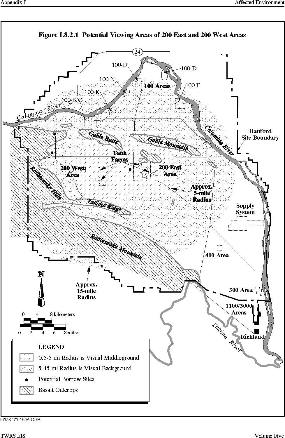
For purposes of study and mapping, viewing areas are generally divided into four distance zones; the foreground, within 0.8 km (0.5 m); the middleground, from 0.8 km to 8 km (0.5 to 5 mi) ; the background, from greater than 8 to 24 km (5 to 15 mi) ; and seldom seen areas that are either beyond 24 km (15 mi) or are unseen because of topography (Figure I.8.2.1).
Hanford Site facilities can be seen from elevated locations such as Gable Mountain, Gable Butte, and Rattlesnake Mountain, which are used by Native Americans for religious purposes, and from offsite locations including State Routes 240 and 24 and the Columbia River. Because of terrain features, distances involved, the size of the Hanford Site, and the size of the individual facilities, not all facilities are visible from the highways or the Columbia River.
Facilities in the 200 East Area are in the interior of the site and cannot be seen from the Columbia River or State Route 24. Large facilities in the 200 East Area may be visible from State Route 240 only as distant background more then 8 km (5 mi) away. Facilities in the 200 West Area can be seen by travelers on an approximately 11 km (7 mi) segment of State Route 240 south of the Yakima Barricade. For these viewers the facilities are in the visual middleground (0.8 to 8 km [0.5 to 5 mi] away). Facilities in the 200 West Area cannot be seen from the Columbia River. Facilities throughout the 200 Areas are visible from elevated locations such as Gable Mountain, Gable Butte, and Rattlesnake Mountain.
Figure I.8.2.1 Viewing Areas of 200 East and 200 West Areas
The potential Vernita Quarry borrow site is situated on a basalt outcrop immediately adjacent to State Route 24. The basalt resource is exposed in basalt cliffs adjacent to the highway and past quarry operations are highly visible. Quarry activities at the site would be visible from the Vernita Bridge, the Hanford Reach, and the Wahluke Slope north of the Columbia River. The quarry would also be readily observed from State Route 24 leading south from the Vernita Bridge. The potential McGee Ranch borrow site would be located west and north of State Route 24 in slightly rolling terrain. The borrow site would be readily visible from State Route 24 south and east of the borrow site. The potential Pit 30 borrow site is located between the 200 East and 200 West Areas and is only visible offsite from elevated locations.
|
NEWSLETTER
|
| Join the GlobalSecurity.org mailing list |
|
|
|