


4.7 METEOROLOGY
This section discusses weather and other meteorological conditions at the sites.
4.7.1 Temperature
The daily maximum and minimum temperatures for each month for Livermore, California, are shown in Table 4.7-1. The mean annual temperature for the 30-year period from 1951 through 1980 was 14.5·C (58.1·F) with daily extremes ranging from –8·C (18·F) to 45·C (113·F).
4.7.2 Precipitation
Most rainfall in the Livermore Valley occurs between October and April. The average annual precipitation for the region is 379 mm (14.9 inches) (NOAA, 1980–1990). Table 4.7-2 contains the average monthly precipitation for the Livermore Valley for the years 1980 through 1990. The annual precipitation at LLNL Site 300 for the 18-year period from 1973 through 1990 was 263 mm (10.34 inches).
4.7.3 Winds
LLNL Livermore Site and SNL, Livermore
The Livermore Valley, in which both the LLNL Livermore site and SNL, Livermore are located, is bowl-shaped, measuring approximately 21 km in length and 7 to 11 km in width. The surrounding hills range from 300 to 600 m above the valley floor. The LLNL Livermore site and SNL, Livermore lie in the southeastern portion of the valley. As airflow moves east through Dublin Gap, it diverges until it encounters Mt. Diablo and the Altamont Hills to the north. These obstructions turn the flow toward the southeast. South of the Dublin Gap, the influence of the foothills of the Diablo Mountain Range and the surrounding Altamont Hills then diverts the airflow towards the northeast. Airflow exits the valley through Altamont Pass, located directly northeast of the LLNL Livermore site and SNL, Livermore. Large-scale upper-air influences either weaken or enhance this surface flow pattern.
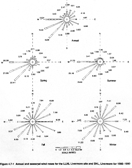
The seasonal and annual wind roses from the 10-m meteorological tower located at the LLNL Livermore site are shown in Figure 4.7-1. The data illustrated are from the years 1986 through 1990.
The annual frequency of the winds at the LLNL Livermore site is shown in Table 4.7-3. The frequency of calm winds (0 to 1 m/sec) is divided among the 16 wind directions according to the frequency of occurrence of the first noncalm wind speed category.
During the summer months, winds are predominantly from the south or southwest as a result of the sea breeze. The sea breeze phenomenon is created when air over land is heated more rapidly by solar radiation than the air over the cooler Pacific Ocean. As the air is heated it rises and begins to develop a circulation, causing the air over the ocean to move inland. During this period of replacement (which typically occurs between 14:00 and 16:00 Pacific Standard Time), the wind velocity increases. This differential heating rarely occurs during the winter months when winds are more evenly distributed because of the passage of winter storms and because the differential temperature between the land surface and ocean water is less.
LLNL Site 300
LLNL Site 300 is located near the northern end of the Diablo Range at a distance of about 15 miles east-southeast of the LLNL Livermore site and SNL, Livermore, and approximately 8 miles southwest of the City of Tracy. The topography of the area varies from rolling hills with relatively flat benches and valleys to steep hills and rugged canyons. The climate is characterized by mild, rainy winters and warm, dry summers. Sunshine is abundant throughout the year. It is officially classified as "Mediterranean Scrub Woodland" climate (Rumney, 1968).
During winter, cyclonic storms affect the region, attended by southerly or southwesterly winds and short periods of rain. As the low pressure passes, light snow sometimes falls over the higher elevations. Following the passage of the low pressure, skies typically clear as the eastern Pacific high builds inland. Occasionally these conditions produce strong northerly surface winds with gusts in excess of 30 m/sec for a day or two.
During nonrainy periods, particularly during December and January, radiation fogs form frequently in the San Joaquin Valley and move over the site.
Summer sea breezes often develop in the afternoon when modified marine air moves through the passes to the west and is funneled through Corral Hollow, of which LLNL Site 300 is a part. A strong sea breeze can reduce maximum temperatures by 5·C or more. This breeze persists into the evening and occasionally throughout the night, resulting in cool temperatures. If the marine layer is sufficiently deep, stratus clouds are advected to within several kilometers of the western boundary. The clouds usually dissipate during the afternoon. The sea breeze ranges between 5 to 15 m/sec but may exceed 20 m/sec at LLNL Site 300.
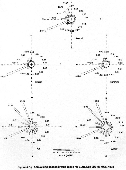
Spring and autumn are typically transitional periods in which no exceptional meteorological phenomena occur. The seasonal and annual frequency of wind occurrence for the period 1986 through 1990 from the 10-m meteorological tower at LLNL Site 300 is shown in Figure 4.7-2. The average annual wind speed percent occurrence for each of the six wind classes during the period 1986 through 1990 is shown in Table 4.7-4.
Table 4.7-1 Daily Maximum, Minimum, and Monthly Temperature (·F)Livermore, California
| Month | Daily Maximum Temperature | Daily Minimum Temperature | Monthly Average Temperature |
| January | 57.0 | 34.7 | 45.9 |
| February | 61.3 | 37.8 | 49.6 |
| March | 64.6 | 38.8 | 51.7 |
| April | 70.1 | 41.4 | 55.8 |
| May | 76.6 | 45.9 | 61.3 |
| June | 83.6 | 50.5 | 67.1 |
| July | 90.0 | 52.7 | 71.3 |
| August | 89.2 | 52.6 | 70.9 |
| September | 86.8 | 51.2 | 69.0 |
| October | 78.7 | 46.4 | 62.6 |
| November | 66.1 | 39.5 | 52.8 |
| December | 57.7 | 35.2 | 46.5 |
| Year Average: | 73.5 | 43.9 | 58.1 |
Source: NOAA, 1980–1990.
Table 4.7-2 Annual Monthly Mean Precipitation (Inches) Livermore Valley, California
| Year | Jan | Feb | Mar | Apr | May | Jun | Jul | Aug | Sep | Oct | Nov | Dec | Annual |
| 1980 | 4.2 | 4.2 | 1.4 | 1.3 | 0.5 | 0.0 | 0.7 | 0.0 | 0.0 | 0.0 | 0.3 | 1.2 | 13.8 |
| 1981 | 4.0 | 1.1 | 2.9 | 0.6 | 0.1 | 0.0 | 0.0 | 0.0 | 0.1 | 2.1 | 3.4 | 2.6 | 16.9 |
| 1982 | 5.3 | 2.2 | 5.6 | 1.5 | 0.0 | 0.3 | 0.0 | 0.0 | 1.5 | 2.2 | 3.7 | 2.8 | 25.1 |
| 1983 | 6.3 | 5.6 | 6.1 | 3.5 | 0.2 | 0.0 | 0.0 | 0.5 | 1.0 | 0.3 | 5.4 | 3.4 | 32.4 |
| 1984 | 0.3 | 1.9 | 1.0 | 0.5 | 0.0 | 0.0 | T | 0.0 | 0.0 | 1.3 | 4.7 | 1.5 | 11.3 |
| 1985 | 0.5 | 1.3 | 2.6 | 0.3 | 0.1 | 0.2 | T | 0.0 | 0.1 | 0.7 | 2.7 | 2.0 | 10.4 |
| 1986 | 2.0 | 7.1 | 4.1 | 0.6 | 0.1 | 0.0 | 0.0 | 0.0 | 0.5 | 0.0 | 0.1 | 0.9 | 15.5 |
| 1987 | 1.8 | 3.5 | 2.3 | 0.2 | 0.1 | ND | 0.0 | 0.0 | 0.0 | 0.9 | 1.4 | 2.3 | 12.4 |
| 1988 | 1.8 | 0.4 | 0.3 | 1.2 | 0.5 | 0.1 | 0.0 | 0.0 | 0.0 | 0.1 | 1.9 | 2.0 | 8.2 |
| 1989 | 0.8 | 1.0 | 2.9 | 0.9 | 0.1 | 0.1 | 0.0 | 0.0 | 1.3 | 1.1 | 1.0 | 0.1 | 9.3 |
| 1990 | 1.5 | 2.5 | 0.9 | 0.4 | 1.8 | T | 0.0 | T | 0.1 | 0.1 | 0.4 | 1.5 | 9.0 |
| Average | 2.6 | 2.8 | 2.7 | 1.0 | 0.3 | 0.1 | 0.1 | 0.0 | 0.4 | 0.8 | 2.3 | 1.8 | 14.9 |
ND = Data not available.
T = Trace, less than 0.01 inch.
Source:
NOAA, 1980–1990.
Table 4.7-3 Wind Frequency Distribution (Percent Occurrence) LLNL Livermore Site* 1986 Through 1990
| Compass Direction | Wind Speed Classes (m/sec) | |||||
| 0–1.3 | 1.3–3.0 | 3.0–5.1 | 5.1–8.2 | 8.2–10.8 | >10.8 | |
| N | 1.3 | 0.72 | 0.84 | 0.72 | 0.23 | 0.05 |
| NNE | 1.56 | 1.4 | 1.52 | 0.48 | 0.05 | 0.01 |
| NE | 1.95 | 1.93 | 1.99 | 0.13 | 0 | 0 |
| ENE | 2.37 | 1.02 | 0.63 | 0.14 | 0.02 | 0 |
| E | 4.01 | 0.68 | 0.21 | 0.06 | 0.01 | 0 |
| ESE | 6.05 | 0.66 | 0.09 | 0.04 | 0.01 | 0 |
| SE | 3.38 | 0.34 | 0.06 | 0.03 | 0.01 | 0 |
| SSE | 2.09 | 0.19 | 0.06 | 0.03 | 0.02 | 0.01 |
| S | 2.52 | 0.95 | 0.16 | 0.04 | 0 | 0 |
| SSW | 2.65 | 2.08 | 0.94 | 0.40 | 0.10 | 0 |
| SW | 2.76 | 4.82 | 5.81 | 2.79 | 0.20 | 0 |
| WSW | 2.58 | 5.85 | 5.26 | 1.67 | 0.06 | 0 |
| W | 1.85 | 3.82 | 5.80 | 1.75 | 0.02 | 0 |
| WNW | 1.3 | 0.94 | 0.85 | 0.33 | 0 | 0 |
| NW | 1.24 | 0.57 | 0.21 | 0.04 | 0 | 0 |
| NNW | 1.25 | 0.58 | 0.43 | 0.18 | 0.02 | 0 |
* Lawrence Livermore National Laboratory, 10-meter
meteorological tower.
Source: LLNL, 1991f.
Table 4.7-4 Wind Frequency Distribution (Percent Occurrence) LLNL Site 300* 1986 Through 1990
| Compass Direction | Wind Speed Classes (m/sec) | |||||
| 0–1.3 | 1.3–3.0 | 3.0–5.1 | 5.1–8.2 | 8.2–10.8 | >10.8 | |
| N | 0.51 | 0.65 | 1.5 | 1.49 | 0.25 | 0.37 |
| NNE | 0.40 | 0.51 | 0.58 | 0.04 | 0 | 0 |
| NE | 0.52 | 1.11 | 0.70 | 0.01 | 0 | 0 |
| ENE | 0.6 | 1.09 | 0.23 | 0.01 | 0 | 0 |
| E | 0.75 | 0.80 | 0.18 | 0.03 | 0 | 0 |
| ESE | 0.69 | 0.46 | 0.13 | 0.10 | 0.03 | 0.01 |
| SE | 0.82 | 0.50 | 0.22 | 0.15 | 0.01 | 0.04 |
| SSE | 1.08 | 0.73 | 0.26 | 0.13 | 0.03 | 0.03 |
| S | 1.35 | 1.02 | 0.30 | 0.16 | 0.04 | 0.01 |
| SSW | 1.22 | 0.86 | 0.28 | 0.13 | 0.06 | 0.03 |
| SW | 0.84 | 0.57 | 0.78 | 0.92 | 1.05 | 1.16 |
| WSW | 0.75 | 0.87 | 2.53 | 11.52 | 11.65 | 5.83 |
| W | 0.86 | 1.13 | 2.53 | 4.82 | 0.89 | 0.13 |
| WNW | 1.06 | 1.05 | 1.42 | 1.38 | 0.21 | 0.04 |
| NW | 1.83 | 2.47 | 2.13 | 2.64 | 1.14 | 0.57 |
| NNW | 0.99 | 1.33 | 2.85 | 3.76 | 1.33 | 1.69 |
* LLNL Site 300, 10-meter meteorological tower.
Source: LLNL, 1991f.
4.7.4 Storm Events
The Livermore Valley and LLNL Site 300 rarely experience severe weather. The greatest annual rainfall during the period between 1931 and 1990 was 1041 mm (41 inches) (NOAA, 1980-1990). During the 5 years between 1986 and 1991, California experienced less than normal precipitation, which is 379 mm (14.9 inches). Annual rainfall for the Livermore region for 1986 through 1990 was only 274 mm (10.9 inches), which is 28 percent below normal. This can be compared to the 508 mm (20.0 inches) average for an earlier 5-year period (1980 through 1984), which is 34 percent above normal. Thunderstorms occur fewer than 10 days per year and are not intense; hail occurs even less frequently.
|
NEWSLETTER
|
| Join the GlobalSecurity.org mailing list |
|
|
|