


4.6 AESTHETICS AND SCENIC RESOURCES
This section discusses the visual and scenic resources of the Laboratory sites and the surrounding areas.
4.6.1 Visual Character of the Project Vicinity
LLNL Livermore Site and SNL, Livermore
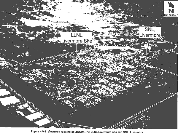
While they are distinct operations managed and operated by different contractors, for purposes of this discussion the LLNL Livermore site and SNL, Livermore are addressed together because of their proximity. The Livermore Valley of eastern Alameda County, where the LLNL Livermore site and SNL, Livermore are located, is ringed by hills and mountains that define the regional viewshed and provide open space around the development on the valley floor. The terrain in the vicinity of the sites ranges from relatively flat land to gently rolling hills. The hills east and south of the LLNL Livermore site and SNL, Livermore gradually become steeper as they trend eastward to form the Altamont Hills of the Diablo Range. Wind turbines north and south of the Altamont Pass punctuate the eastern horizon and have become part of the eastern valley landscape identity. Figure 4.6-1 shows an oblique aerial view of the LLNL Livermore site and SNL, Livermore looking southeast toward the Altamont Hills.
The area surrounding the LLNL Livermore site and SNL, Livermore is generally rural and pastoral because of the surrounding hillside open space. Rural residences and grazing land are the primary visual features to the south and east of the sites. The rural character continues to the southwest, where large vineyards are the primary visual features. West of the LLNL Livermore site, existing and newly constructed residential areas of the City of Livermore provide a more suburban character. The area extending north from the LLNL Livermore site to I-580 is industrial, and provides a visual continuation of the research, business, and industrial character of the LLNL Livermore site. Primary features are one- and two-story industrial buildings, business parks, and the Union Pacific and Southern Pacific railroad lines that traverse the area.
LLNL Site 300
LLNL Site 300 is located in the Altamont Hills of the Diablo Range, where the nearby topography varies from rolling hills to steep ridges and valleys. The surrounding area is primarily undeveloped and rural in character. LLNL Site 300 is visible from Corral Hollow Road, that forms its southern boundary.
Physics International operates a testing facility adjacent to and northeast of LLNL Site 300. Although the sign at the entrance to Physics International is visible from Corral Hollow Road, because of the topography of the site, the structures are not. The SRI International testing facility, in the hills approximately 0.6 mile south of LLNL Site 300, is not visible from Corral Hollow Road.
Carnegie State Vehicular Recreation Area is south of the western portion of LLNL Site 300 and is visible from Corral Hollow Road. The hillsides of the park, used for off-road vehicle riding, are lined with dirt trails. A ranger station and picnic area near the park entrance are also visible from Corral Hollow Road.
4.6.2 Views of the Sites from Surrounding Areas
LLNL Livermore Site and SNL, Livermore
While they are distinct operations managed and operated by different contractors, for purposes of this discussion the LLNL Livermore site and SNL, Livermore are addressed together because of their proximity. The LLNL Livermore site has a campus or business park–like setting with buildings, internal roadways, pathways, and open space. Portions of the site along the western and northern boundaries remain undeveloped and serve as security buffer areas. A row of eucalyptus and poplar trees surrounds much of the developed portion of the LLNL Livermore site, screening most ground-level views of the facility. Onsite buildings range in height from 10 to approximately 110 ft. A 9-ft-high, chain-link and barbed-wire security fence surrounds the LLNL Livermore site.
The central area of the SNL, Livermore site is developed with structures, roadways, and parking areas. An open space area, ranging in width from approximately 600 to 1200 ft, borders the developed area on the west, south, and east. Onsite buildings range in height from 10 to approximately 40 ft. A 9-ft-high, chain-link and barbed-wire security fence runs along the perimeter of SNL, Livermore.
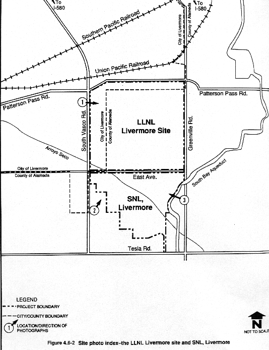
The existing visual character of the LLNL Livermore site and SNL, Livermore is illustrated by several photographs taken of the sites from nearby sensitive viewpoints (e.g., residences and scenic roadways). Figure 4.6-2 indicates where the photographs depicted in Figures 4.6-3 through 4.6-5 were taken, and the directions of the views.
The LLNL Livermore site is relatively distant from I-580 (approximately 1.5 miles) and only the tallest onsite building is visible from this highway. Much of the site is prominently visible, however, when approaching from the north on Vasco Road.
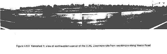
A tract of single-family residences on the southwest corner of Patterson Pass Road and Vasco Road has a view of the northwest corner of the LLNL Livermore site. Figure 4.6-3 shows the view of the LLNL Livermore site looking southeast from these residences. The view consists of the security fencing in the foreground, the 500-ft open space buffer along Vasco Road in the midground, and the row of high-standing eucalyptus trees in the background. Few onsite structures are visible from this residential area.
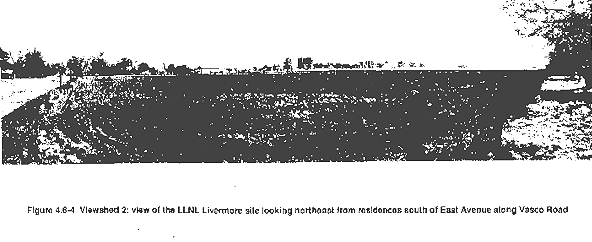
The LLNL Livermore site is also prominently visible when approaching the site from the south on Vasco Road. Several scattered residences along Vasco Road south of East Avenue have a direct view. Figure 4.6-4 presents a view of the LLNL Livermore site looking northeast from a residence on Vasco Road, approximately 1800 ft south of East Avenue. Structures and landscaping in the southwestern quadrant of the LLNL Livermore site are visible from this vantage point.
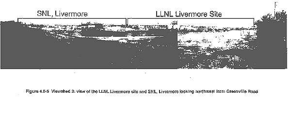
When approaching from the south on Greenville Road (a City of Livermore and Alameda County scenic roadway), the LLNL Livermore site and SNL, Livermore are intermittently visible among the rolling hillsides. Figure 4.6-5 provides a view of the LLNL Livermore site and SNL, Livermore looking northwest from Greenville Road approximately 2000 ft south of East Avenue. A panoramic view of both sites is offered from this section of Greenville Road. Structures, parking lots, and onsite landscaping are visible in the background, and the open space security buffer bordering the developed portion of SNL, Livermore is visible in the foreground.
LLNL Site 300
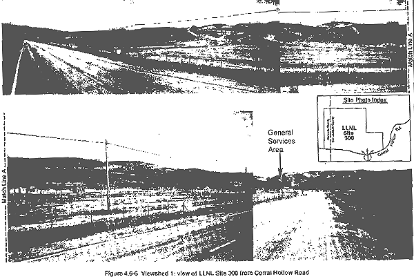
The I-580 freeway is approximately 2 miles east of LLNL Site 300 and is designated as a scenic highway by the State of California; however, because of distance and intervening topography, LLNL Site 300 is not visible from the I-580 corridor. Corral Hollow Road, which is adjacent to and south of LLNL Site 300, is the only public roadway in the vicinity with a view of the site. The view consists of parking areas and several single-story structures in the General Services Area. The view of the LLNL Site 300 General Services Area from Corral Hollow Road is shown in Figure 4.6-6. The remainder of the view of LLNL Site 300 from Corral Hollow Road consists of rolling hillsides and a few scattered small structures on the hilltops. Other than the General Services Area, the facilities of LLNL Site 300 are not apparent in landscape views from publicly accessible viewpoints; however, a 3-ft-high wire fence surrounding LLNL Site 300 is visible from Corral Hollow Road, along the site's southern boundary.
LLNL Site 300 can be seen from the Carnegie State Vehicular Recreation Area, which lies directly south. One single-story structure (Building 899) and its surrounding light posts are visible from the park. From the picnic area near the park entrance, the view of LLNL Site 300 consists primarily of undeveloped hillsides.
4.6.3 Scenic Resources Policies
LLNL Livermore Site and SNL, Livermore
While they are distinct operations managed and operated by different contractors, for purposes of this discussion the LLNL Livermore site and SNL, Livermore are addressed together because of their proximity.
County of Alameda
Scenic Route Element of the County of Alameda General Plan. The scenic route element of the County of Alameda General Plan was adopted by the Alameda County Board of Supervisors in May 1966. This element, consisting of text and a map, is designed to serve as a guide for establishment of programs and legislation for the development of a system of scenic routes. A primary goal of the element is the preservation and enhancement of scenic qualities and natural scenic areas adjacent to and visible from scenic routes. The element contains objectives, definitions, policies, standards, and implementation measures (County of Alameda, 1966).
Scenic routes are defined as consisting of three elements: the right-of-way, the adjacent scenic corridor, and areas extending beyond the scenic corridor. Scenic corridors are either areas that extend beyond a scenic route right-of-way and are of sufficient scenic quality to be acquired by state or local jurisdictions, or areas to which development controls should be applied to preserve and enhance nearby views or maintain unobstructed distant views along a scenic route and provide a pleasant route of travel (County of Alameda, 1966).
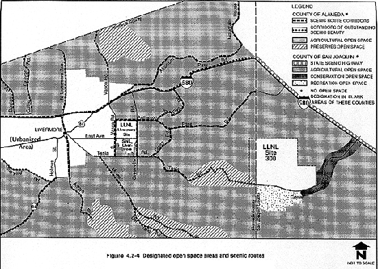
Figure 4.2-4 in section 4.2 illustrates the scenic routes designated in the County of Alameda scenic route element. The following roadway segments in the vicinity of the LLNL Livermore site and SNL, Livermore are designated as scenic routes according to the element:
- Interstate 580 (I-580)
- Vasco Road
- Patterson Pass Road (from Vasco Road to the San Joaquin County border)
- Tesla Road (from Vasco Road to the San Joaquin County border)
- Greenville Road (from I-580 to Tesla Road)
- Altamont Pass Road (from I-580 to Route 239)
- Cross Road (from Patterson Pass Road to Tesla Road)
A summary of relevant policies excerpted from the County of Alameda scenic route element includes the following:
- Provide for Normal Uses of Land and Protect Against Unsightly Features. In both urban and rural areas, normally permitted uses of land should be allowed in scenic corridors, except that panoramic views and vistas should be preserved and enhanced by supplementing normal zoning regulations with special height, area, and sideyard regulations; and by providing architectural and site design review.
- Use Landscaping to Increase Scenic Qualities of Scenic Route Corridors. Landscaping should be designed and maintained in scenic route corridors to provide added visual interest, to frame scenic views, and to screen unsightly views.
- Underground Utility Distribution Lines When Feasible; Make Overhead Lines Inconspicuous. New, relocated, or existing utility distribution lines should be placed underground whenever feasible. When it is not feasible to place lines underground, they should be inconspicuous from the scenic route. Poles of an improved design should be used wherever possible. Combined or adjacent rights-of-way and common poles should be used wherever feasible.
- Control Tree Removal. As a means of preserving the scenic quality of the county, no mature trees should be removed without permission from the local jurisdiction.
City of Livermore
Scenic Route Element of the Livermore General Plan 1976–2000. The scenic route element of the Livermore General Plan 1976–2000, adopted by the Livermore City Council on October 11, 1977, is designed to guide the preservation and enhancement of scenic values along the streets and highways in the Livermore Valley. It also aims to preserve and enhance scenic values that are of outstanding quality or that provide access to important scenic, recreational, cultural, or historic points. Further, the scenic route element provides a comprehensive plan and expands the scenic route plans of Alameda County and CALTRANS within the Livermore Planning Area. The Livermore General Plan scenic route element incorporates the County of Alameda scenic route element, adding local routes with scenic qualities (City of Livermore, 1977b).
The following roadway segments in the vicinity of the LLNL Livermore site and SNL, Livermore are designated as scenic routes in the city's scenic route element (City of Livermore, 1977b) (see Figure 4.2-4 in section 4.2):
- Interstate 580 (I-580)
- Greenville Road
- Tesla Road
- Altamont Pass Road
- Patterson Pass Road
- Flynn Road
The policies in the scenic route element of the Livermore General Plan 1976–2000 are similar to those contained in the scenic route element of the County of Alameda General Plan (County of Alameda, 1966). These policies address the use of landscaping to increase the scenic qualities of scenic corridors and encourage the use of underground utilities and the preservation of mature trees (City of Livermore, 1977b).
LLNL Site 300
County of San Joaquin
Scenic Highways Element of the San Joaquin County General Plan. The scenic highways element of the County of San Joaquin General Plan was adopted by the San Joaquin County Board of Supervisors on October 19, 1978. The purpose of the element is to establish scenic routes in the county and to guide the preservation and enhancement of scenic qualities and natural scenic areas adjacent to and visible from scenic routes (County of San Joaquin, 1978b).
San Joaquin County recognized the value of scenic resources surrounding a 16-mile portion of I-580 and I-5 between Stanislaus and Alameda counties and, in 1974, adopted a Scenic Corridor Zone, designed to give aesthetic protection to county-designated scenic highways. Later in 1974, this 16-mile segment of I-580 and I-5 received official designation as a state scenic highway by its inclusion in the State Master Plan of Scenic Highways. No other highways or roadways within San Joaquin County have been identified as scenic. Figure 4.2-4 in section 4.2 shows the location of a segment of the I-580 state scenic highway corridor within San Joaquin County.
|
NEWSLETTER
|
| Join the GlobalSecurity.org mailing list |
|
|
|