


4.8 GEOLOGY
This section provides an overview of the affected physical environment, including discussions of the local and regional geologic setting, stratigraphy (rock and sediment types), soils, economic geology, structural geology, and geological hazards (including seismicity). A discussion of existing contamination in the soils at the sites is included in section 4.17.
4.8.1 General Geology
Topography and Geomorphology
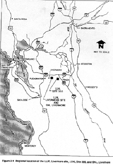
The LLNL Livermore site, LLNL Site 300, and SNL, Livermore are located in the California Coast Ranges geologic province (Dibblee, 1980a, 1980b) characterized by low rugged mountains and relatively narrow intervening valleys. Figure 2-1 shows the location of the LLNL Livermore site, LLNL Site 300, and SNL, Livermore relative to the surrounding area.
LLNL Livermore Site and SNL, Livermore
The LLNL Livermore site and SNL, Livermore are located in the southeastern portion of the Livermore Valley. The valley forms an irregularly shaped lowland area about 16 miles long east-to-west and 7 miles to 10 miles wide north-to-south. The floor of the valley slopes to the west at about 20 ft per mile.
In general, the LLNL Livermore site and SNL, Livermore are located on relatively flat foothills that have low relief and slope gently northwest and north. Slopes at the LLNL Livermore site do not generally exceed a 1-degree inclination while those at SNL, Livermore vary from 1 to 3 degrees (U.S. Department of Agriculture Soil Conservation Service, 1966). The southern area of SNL, Livermore is situated on the north side of a ridge approximately 150 ft (46 m) above the surrounding land. The SNL, Livermore property ranges in elevation from 849 ft (259 m) above mean sea level (MSL) at the south end of the SNL, Livermore ridge top to 615 ft (187 m) at the northwest corner of the site. The LLNL Livermore site property ranges in elevation from 676 ft (206 m) in the southeast corner to 571 ft (174 m) in the northwest corner.
LLNL Site 300
LLNL Site 300 is located in the Altamont Hills near the western boundary of San Joaquin County. The site occupies approximately 7000 acres of steep ridges and canyons with a decrease in elevation toward the southeast. Slopes range from 8 degrees to greater than 45 degrees in the canyons. In the General Services Area located in the southeastern portion of the site, slopes can be as low as 2 or 3 degrees (U.S. Department of Agriculture Soil Conservation Service, 1990). The maximum elevations onsite are found in the northwest portions of LLNL Site 300 and range from 1476 ft (450 m) to 1722 ft (525 m) above mean sea level. The lowest elevation onsite, where Corral Hollow Creek follows the southern LLNL Site 300 southern boundary, is approximately 500 ft (152 m) above mean sea level.
Structural Geology
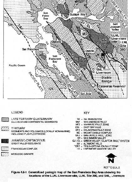
A generalized map of the regional structural geology and physiography of the San Francisco Bay Area is presented in Figure 4.8-1. The Diablo Range, which includes the Altamont Hills, is part of the northwest-trending Coast Ranges, and parallels three major faults in the area (Nilsen, 1977; Atwater, 1970). These include the San Andreas fault system, the Sur-Nacimiento fault, and the Coast Range thrust fault system (the Sur-Nacimiento fault and the Coast Range thrust are not exposed in the area shown in Figure 4.8-1). These faults can generally be considered to define three different lithologic blocks (Page, 1966). The westernmost block is the Salinian Block, which lies west of the San Andreas fault shown in Figure 4.8-1. This block consists primarily of metamorphic and granitic rock. To the east of the Salinian Block is the Franciscan Assemblage, lying between the San Andreas and the Coast Range thrust fault zones. It is composed of marine sedimentary and volcanic rocks. The next block positioned above the Coast Range thrust fault zone consists of late Mesozoic through late Tertiary marine sedimentary rocks overlying complex ancient oceanic and continental crust rocks. This block lies primarily along the eastern margin of the Coast Range Province. Structural relationships along the Coast Range thrust are complex due to later reactivation of the thrust by high-angle normal and strike slip faults.
The Hayward fault, which is part of the San Andreas fault system (see Figure 4.8-1), forms the western boundary of the East Bay Hills and is located about 17 miles west of the LLNL Livermore site. Another branch of the San Andreas fault system, the Calaveras fault zone, trends northwest through the San Ramon Valley, which borders the Livermore Valley to the west. A major structural feature north of the Livermore Valley is the Mount Diablo Complex. This complex consists of folded and thrust faulted rock in the vicinity of Mount Diablo and the surrounding hills (Page, 1966). This complex is bordered on the northeastern edge by the Green Valley–Clayton fault system. The Suisun Bay is to the north and the Livermore Valley to the southeast flank of the Diablo Complex. The two regional northwest-southeast trending fault zones located closest to the Laboratories are the Greenville fault zone and the Tesla-Ortigalita fault zones, both shown in Figure 4.8-1.
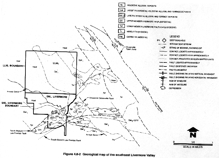
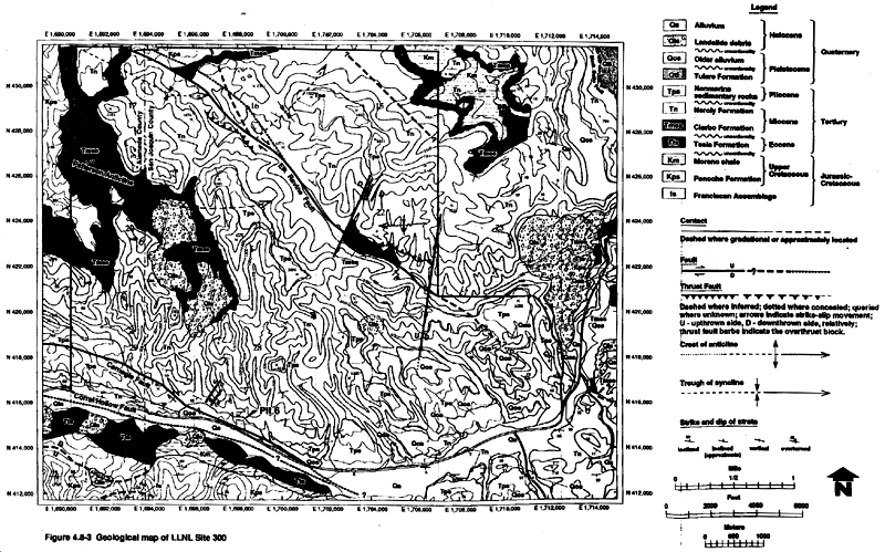
A geologic map showing general geologic structures including faults mapped in the vicinity of the LLNL Livermore site and SNL, Livermore is presented in Figure 4.8-2. Geologic structures mapped at LLNL Site 300 are shown in Figure 4.8-3. It contains the most accurate depiction of bedrock geology; however, Figure 4.8-8 should be used for landslides and fault mapping. More detailed discussions of faulting in the LLNL/SNL, Livermore vicinity are presented in section 4.8.3 and in Appendix I.
Stratigraphy
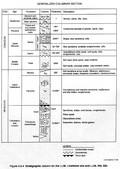
Figure 4.8-4 presents a schematic stratigraphic column of rocks outcropping at the LLNL Livermore site, LLNL Site 300, and SNL, Livermore.
A geologic map showing the distribution of geologic materials mapped at the LLNL Livermore site and SNL, Livermore is presented in Figure 4.8-2. The distribution of rock types mapped at LLNL Site 300 is shown in Figure 4.8-3. The Diablo Range consists primarily of metamorphic and igneous rocks known as the Mesozoic Franciscan Assemblage (Dibblee 1980a, 1980b). These formations extend to, and in places are overlain by, oceanic crustal and marine sedimentary rocks from late Mesozoic and late Tertiary ages (California Division of Mines and Geology, 1964).
The Franciscan Assemblage generally contains metamorphic rocks known as graywacke, metagraywacke, shale or argillite, blueschist, greenstone; some limestones and cherts; and assorted igneous rocks. These assorted rock types are present throughout the Franciscan Assemblage but have been deformed and are discontinuous.
Overlying the Franciscan Assemblage are sedimentary rocks known as the Great Valley Sequence, which consists of layers that are somewhat deformed (Ingersoll, 1981). The Great Valley Sequence is thought to have formed during the late Mesozoic within a basin resting between the Sierra Nevada, which was then the location of a volcanic island–arc, and a trench to the west (Page, 1981; Atwater, 1970). Outcrops of the Great Valley Sequence are seen in the Altamont Hills east of Livermore, and especially along the eastern edge of the Coast Ranges. The Franciscan Assemblage is thought to have been formed as an accretionary wedge of trench sediments that were thrust beneath the western edge of the Great Valley Sequence deposits (Hamilton, 1969; Ernst, 1970; Hsu, 1971). The contact between the Great Valley Sequence and the Franciscan Assemblage is the Coast Range thrust and is seen along the eastern margin of the Coast Ranges.
LLNL Livermore Site and SNL, Livermore
The sediments beneath the Livermore Valley range in age from Jurassic to Quaternary (see Figure 4.8-4). A large volume of the valley sediment is composed of late Tertiary and Quaternary alluvial sediments known as the Livermore Formation (Carpenter et al., 1984; The Mark Group, 1986). The maximum thickness of the Livermore Formation is thought to be approximately 4000 ft (1219 m). This formation has been divided into Upper and Lower Members (Huey, 1948; Thorpe et al., 1990). The Upper Member of the Livermore Formation is characterized by massive gravel beds mixed with sand, silt, and clay. The Lower Member of the Livermore Formation is dominated by greenish- to bluish-grey silt and clay, with lenses of gravel and sand (Huey, 1948; Thorpe et al., 1990). For additional information on the local stratigraphic units and hydrogeology at the LLNL Livermore site and SNL, Livermore see section 4.11.2.2.
LLNL Site 300
Sedimentary rocks at LLNL Site 300 are similar to those present in the vicinity of the Livermore Valley. This hilly terrain contains sedimentary units that dip 5 to 10 degrees or more to the east and southeast. Some older formations, including the Upper Cretaceous Panoche Formation, are exposed in limited areas of the northwest and northeast corners of the site. A majority of the exposed strata onsite are of Tertiary age, including the Miocene Cierbo and Neroly Formations. The Miocene Neroly Formation is exposed over the greatest areal extent of all sedimentary units onsite. Pliocene nonmarine sedimentary rocks may have formed at the same time as the Livermore Formation in the Livermore Valley and occupy a similar position in the stratigraphic column. In addition, younger Quaternary alluvial deposits are present onsite in limited areas, but most have been removed by erosion. For additional information on the local LLNL Site 300 stratigraphy and hydrogeology, see section 4.11.2.2.
Soils
LLNL Livermore Site and SNL, Livermore
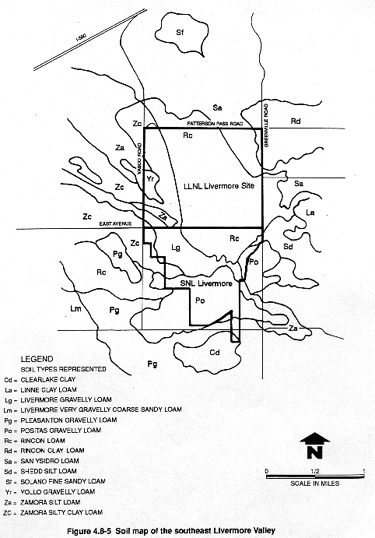
A generalized map of the soils of the Livermore area is shown in Figure 4.8-5. The soils in the Livermore Valley beneath the LLNL Livermore site and SNL, Livermore are formed primarily upon sediments deposited by local streams. Most of the deposits in the eastern part of the valley are relatively young, and thus soils are only moderately developed. These soils (generally loam) have minimal horizon or development of layers, and can be locally several meters thick. The soils are used for crop production when provided with sufficient water and nutrients or minerals (Brady, 1974; U.S. Department of Agriculture Soil Conservation Service, 1966). Four soils cover most of the LLNL Livermore site vicinity. In order of decreasing extent they are: Rincon loam, Zamora silty clay loam, Positas gravelly loam, and Rincon clay loam. These soils are primarily Alfisols, or moderately developed soils, and grade into Mollisols, which are grassland soils (Brady, 1974).
LLNL Site 300
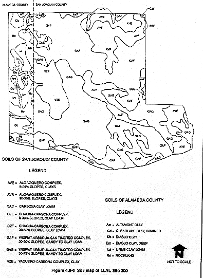
A generalized map of LLNL Site 300 soils is provided in Figure 4.8-6. The LLNL Site 300 soils have developed on marine shales and sandstones, uplifted river terraces, and fluvial deposits. They are classified as loamy Entisols. Entisols are young soils that have little or no horizon development. Clay rich soils (Vertisols) are also present and have been mapped as the Alo-Vaquero complex. Vertisols are mineral soils characterized by a high clay content that display shrink/swell capability. The remaining soil types identified at LLNL Site 300 occur only in limited areas. These units are mixtures of the soils described and are not readily separable, including grassland Mollisols, or are poorly developed Inceptisols (U.S. Department of Agriculture Soil Conservation Service, 1966, 1990). All LLNL Site 300 soil types are potentially useful for limited agriculture but are constrained by location and steepness of the slopes. The loamy soils easily erode, and vegetation can be churned into the soil by moderate livestock or other traffic during wet periods. Vertisols exhibit low permeability and are subject to moderate erosion. Wildlife habitat and limited grazing by livestock are the best use of these soils.
Soil properties and extent are important factors in evaluating potential transport of contaminants. A discussion of the distribution of soil and sediment contamination at LLNL and SNL, Livermore is presented in section 4.17. Hazardous materials, if sorbed to surficial soil, might potentially leave the LLNL Livermore site, LLNL Site 300, and SNL, Livermore as components of airborne dust particles, or be transported by surface water flow. Soil properties, especially infiltration capacity, govern the transport of hazardous material to the saturated zone. For example, the infiltration rates in the LLNL retention basin varied from 0.01 ft/day near the center, where a silt layer had been deposited on the basin floor, to 1.9 ft/day in the banks of the basin (Toney, 1990). Based on percolation and whole-trench tests, reported surface infiltration rates in the recharge basin south of the LLNL Livermore site range from 0.24 to 10 ft/day, depending on lithology (Dresen et al., 1988). The USDA estimated the permeability for undisturbed soils covering the central and eastern areas of the LLNL Livermore site at approximately 0.4 to 1.6 ft per day. With the exception of parts of the western and northern areas, most LLNL Livermore site soil has been paved over, compacted, or reworked for landscaping, thus lowering its natural permeability.
4.8.2 Geologic Resources
The geologic resources found on or near the LLNL Livermore site, LLNL Site 300, and SNL, Livermore include aggregate deposits, mineral deposits, fossil occurrences, and petroleum. These resources are described below.
Aggregate Deposits
The present and potential stone and aggregate resources of the eastern Livermore Valley and western San Joaquin County were assessed in 1987 and 1988 (California Division of Mines and Geology, 1987, 1988). Mineral Resource Zones have been established that identify sand, gravel, and stone source areas. Within the eastern Livermore Valley several deposits have been identified as recoverable and marketable resources. Land that is currently developed for urban areas, industry, or research, including the LLNL and SNL, Livermore sites, was not included in these inventories. The estimated gravel resource for the eastern Livermore Valley, western San Joaquin County, and vicinity is 570 million tons with 242 million tons of reserves. Several gravel quarries have operated in the Livermore-Pleasanton valley west of the City of Livermore. Large reserves and resources of gravel are described for the area of western San Joaquin County south of Tracy (California Division of Mines and Geology, 1988); this area contains at least one large-scale gravel quarry. No sand or gravel resources have been assessed within the drainage basin of Corral Hollow Creek (i.e., Corral Hollow and LLNL Site 300), but there is a potential for interest in the alluvial fan deposits northeast of Interstate 580 (California Division of Mines and Geology, 1988).
Mineral Resources
Three types of mineral resources, clay, coal, and silica (California Division of Mines, 1950), have been mined or have the potential to be mined in the vicinity of the LLNL Livermore site, LLNL Site 300, and SNL, Livermore. Clays found in this region have been used for brick, sewer pipe, and roofing tile. Significant clay deposits are associated with outcrops of the Eocene Tesla Formation near the old settlement of Tesla in Corral Hollow, and some clays have been excavated from the perimeter of the Livermore Valley (California Division of Mines, 1950). The clay beds near Tesla were mined from 1897 to 1912. Extensive clay deposits still remain, but the need for and cost of subsurface mining prevents the economic exploitation of these deposits (California Division of Mines, 1957).
Lignite coal was discovered near the settlement of Tesla before 1857. This coal was often found layered with clays in the Tesla Formation and was mined between 1897 and 1902. During that time more than 70,000 tons per year of lignite coal were produced (California Division of Mines, 1950). Silica was mined in an unspecified location in the hills north and west of Corral Hollow from a high silica Tesla Formation sandstone. The extent of this resource is presently unknown. This material was mined only intermittently, for use in refraction of machine parts and for furnace linings (California Division of Mines, 1950).
Several occurrences of other potentially economically valuable mineral deposits are within a 10-mile radius of the LLNL Livermore Site and SNL, Livermore. These include deposits of manganese, chromium, clay, gemstones, pyrite, dimension stone, sand and gravel, and natural gas. Past production statistics and the current development status of these mineral resources are unknown. No commercially exploitable mineral deposits are known to exist within the boundaries of the LLNL Livermore site, LLNL Site 300, or SNL, Livermore.
Fossil Occurrences
Fossils in the eastern Livermore Valley and the hills to the east are principally found in unconsolidated and poorly consolidated Cenozoic deposits. Fossil-bearing units are depicted on the generalized stratigraphic column in Figure 4.8-4. The primary fossil-bearing units are the Miocene Neroly and Cierbo formations, and some younger units of Pleistocene age (Hansen, 1991).
LLNL Livermore Site and SNL, Livermore
The only vertebrate fossil deposits in the vicinity of the LLNL Livermore site or SNL, Livermore are in the Quaternary deposits of the surrounding low hills of the east Livermore Valley, but the fossils are few in number and quite scattered. They have been tentatively identified as Rancho La Brean and Blancan in age (Pleistocene) and consist of bone fragments of the mammoth and giant sloth (Hansen, 1991). Invertebrate shells and leaf and stem fossils have also been found. These appear to be randomly dispersed, mainly within the Neroly Formation. No invertebrate or botanical fossil deposits of significance are believed to be present in the eastern Livermore Valley (Hansen, 1991).
LLNL Site 300
Several vertebrate fossil deposits have been found in the vicinity of LLNL Site 300 and Corral Hollow. Most finds have been a result of road improvement or erosion along stream banks. Nearly all bone fragments found are considered to be Clarendonian age (Miocene) and are scattered within the Neroly Formation. An assortment of mammalian groups are represented: camelids, mastodon, assorted early horses, shrews, beavers, and squirrels. Fossil finds are generally widely scattered, and none consist of more than one or a few fragments of bone. The eroded terraces of exposed Neroly Formation on the south side of Corral Hollow Creek, adjacent to LLNL Site 300 are the only places where numerous fragments have been recovered (Hansen, 1991).
Gravels from the Franciscan Assemblage are known to contain Icthyosaurus fossils, but no fossil locales have been mapped (California Division of Mines and Geology, 1964). An occasional vertebrate bone fragment has been found within LLNL Site 300. In May 1991, numerous fossil bones and bone fragments were found on the fire trail and road improvement areas along the ridge south of Building 827. The locale was secured and is in the process of being assessed. The fossils are within the Neroly Formation and were tentatively identified as mastodon, horse, and an extinct predator. Invertebrate shells, primarily oysters, have been recovered from the Cierbo Formation. Stem and leaf fossils are found in many places within the finer-grained lower Neroly Formation. The fossils are generally scattered, and no significant invertebrate or botanical fossil locales have been identified on LLNL Site 300 or in the surrounding area (Hansen, 1991).
Petroleum Production
The Livermore oil field just east of the LLNL Livermore site was discovered in 1967 and to date is the only oil field in the Livermore–San Ramon Valley area (California Division of Oil and Gas, 1982). According to Carpenter et al. (1984), the Livermore oil field was originally operated by the Hershey Corporation and consisted of 10 producing wells. These wells are located east of the northeastern corner of the LLNL, Livermore site. Production is primarily from Miocene Cierbo Formation sandstones from depths of 900 to 2000 ft (274 to 610 m). The Livermore oil field is now operated by the American Exploration Corporation. Of the original 10 wells, 5 are still producing an average of seven barrels of oil per day; 1 well has been plugged and abandoned; 3 wells have been shut in; and 1 well is now used for saltwater injection (Reid, 1991). Reserves are thought to be only about 132,000 barrels and production is declining (California Division of Oil and Gas, 1986). No oil or gas exploration is currently being conducted or proposed for the Livermore Valley or in the hills to the east (Reid, 1991).
4.8.3 Geologic Hazards
Seismicity of the LLNL Livermore Site and SNL, Livermore
This evaluation of seismic hazards for the LLNL Livermore site and SNL, Livermore is based on a review of (1) published literature, (2) internal LLNL and SNL, Livermore geologic and seismological reports, (3) the seismicity of the region, and (4) probabilistic seismic hazard analyses of the Laboratory sites. For comparison, deterministic seismic hazard analyses were conducted for each site and response spectra were produced for the engineering evaluation of structures. Appendix I contains the results of these seismic hazard analyses and the evaluation of structures.
The LLNL Livermore site and SNL, Livermore are located near the boundary between the North American and Pacific tectonic plates, and the area is characterized by the San Andreas fault system which trends northwest (Figure 4.8-1). Three principal components of the San Andreas fault system, the San Andreas, Hayward, and Calaveras faults, have produced the majority of significant historical earthquakes in the Bay Area. These three faults also accommodate the majority of slip along the Pacific and North American plate boundary and they would likely continue to generate moderate to large earthquakes more frequently than other faults in the region. These faults, and other faults in the vicinity of the Laboratory sites, are described in more detail in Appendix I. While the 1906 Great San Francisco Earthquake (of estimated magnitude 8.3) on the San Andreas fault produced limited structural damage in the Livermore Valley, the local faults in the Livermore Valley region are still the main seismic hazard to the LLNL Livermore site and SNL, Livermore (Scheimer, 1985). The potential for local, damaging earthquakes was highlighted by the January 1980 Livermore earthquake sequence on the Greenville fault, which produced two earthquakes of magnitudes 5.5 and 5.6 (Bolt et al., 1981). The first earthquake caused discontinuous surface displacements along 6.2 km of the fault and produced a maximum peak ground acceleration of 0.26g (where 1.0g = acceleration due to gravity) at nearby Lake Del Valle. The earthquake caused structural and nonstructural damage to the LLNL Livermore site and SNL, Livermore facilities.
The eastern San Francisco Bay Area is dominated by a series of northwest-trending epicentral zones and a matrix of more randomly distributed epicenters that do not display any obvious relation to the faults (Ellsworth et al., 1982). While many faults are identified easily by concentrations of earthquakes, others such as those in the Livermore Valley are not easily located through such seismic activity (Ellsworth et al., 1982). The most pronounced pattern of seismicity in the valley is associated with the 1980 Livermore sequence earthquake along the Greenville fault. A less well defined area of activity may be associated with either the Williams or the Valle fault.
In most cases, earthquakes in the Livermore Valley region have occurred on strike-slip faults, generally indicating north-south oriented compression (Scheimer et al, 1982; Followill and Mills, 1982). Microseismicity occurs along much of the length of the Calaveras fault. The 30-km segment from Calaveras Reservoir to Dublin (the segment nearest the LLNL Livermore site and SNL, Livermore) may be capable of generating a magnitude 6 to 6.5 earthquake (Oppenheimer and MacGregor-Scott, 1991).
Additional information regarding seismic activity in the vicinity of the LLNL Livermore site and SNL, Livermore is presented in Appendix I.
Seismic Hazards
Ground Motion. Strong earthquake ground motion is responsible for producing almost all damaging effects of earthquakes, except for surface-fault rupture. Ground shaking generally causes the most widespread effects, not only because it propagates considerable distances from the earthquake source, but also because it may trigger secondary effects from ground failure and water inundation. Potential sources for future ground motion at the LLNL Livermore site and SNL, Livermore include the major regional faults, as well as the local faults including the Greenville, Las Positas, Verona, Corral Hollow–Carnegie, and Williams faults (Geomatrix Consultants, 1991).
Seismic hazard analyses have been performed for the LLNL Livermore site and SNL, Livermore to quantify the hazard. The analyses identify the probability of exceeding a given peak ground acceleration and are summarized in Table 4.8-1. A deterministic analysis was used to estimate the possible intensity of future earthquake ground shaking at both the LLNL Livermore site and SNL, Livermore. Using various mean and standard deviation relations, a magnitude 6.6 earthquake on the Greenville fault at a distance of 1.5 km from the LLNL Livermore site will produce estimated average peak ground accelerations of 0.47 to 0.76g (Table I-4 in Appendix I). A magnitude 6.0 earthquake on the Las Positas fault at a distance of 0.1 km from SNL, Livermore would generate average horizontal peak ground accelerations of 0.38 to 0.64g (Table I-5 in Appendix I). See Appendix I for more detailed information related to this deterministic analysis.
Larger earthquakes on more distant faults such as the San Andreas do not significantly affect the hazard estimation for either the LLNL Livermore site or SNL, Livermore.
Surface Faulting. Surface faulting is the displacement of ground along both sides of a "trace," the surface expression of an earthquake fault. The potential for surface faulting within the LLNL Livermore site is very low, although potential for surface faulting does exist at SNL, Livermore. The north branch of the Las Positas fault runs along the northern edge of SNL, Livermore Buildings 970, 972, 973, and 976; therefore, these structures are exposed to the greatest risk of damage from surface faulting. Because of the limited amount of subsurface information about the fault and the relatively wide fault zone (Carpenter et al., 1984), additional unrecognized faults of the Las Positas fault zone may be present beneath the SNL, Livermore facilities.
Liquefaction. Liquefaction is a type of soil failure in which a mass of saturated soil is transformed from a solid to a fluid state in response to earthquake shaking. The liquefaction potential of a soil deposit is controlled by several factors, including the depth to ground water, the type and density of the soil, and the intensity and duration of ground shaking. Depths to ground water range from about 43 to 161 ft (13 to 49 m) beneath the LLNL Livermore site and from about 89 to 125 ft (27 to 38 m) beneath SNL, Livermore (Carpenter et al., 1984). Based on the fairly deep ground water levels, the uniformly distributed, poorly sorted sediments beneath the sites, and a relatively high degree of sediment compaction, the potential for damage from liquefaction at the LLNL Livermore site and SNL, Livermore is quite low.
Seismically Induced Landslides. The LLNL Livermore site consists of a relatively smooth land surface that slopes gently to the northwest. Ground surface elevations within the laboratory range from a low of 571 ft (174 m) at the northwest corner of the site to 676 ft (206 m) at the southeast corner. There is little potential for slope instability at the LLNL Livermore site because of the very low relief.
The SNL, Livermore site consists of two different types of terrain separated by the north branch of the Las Positas fault. The area north of the fault consists of a relatively smooth land surface that gently slopes downward to the northwest. Because of the very low relief, the potential for slope instability on the northern portion of SNL, Livermore is remote. The terrain south of the Las Positas fault, however, contains greater relief and steeper slopes which increase the potential for slope instability. The potential for slope instability in the southern portion of SNL, Livermore is considered moderate.
Demand Criteria for EIS/EIR
Maximum horizontal peak ground accelerations at the LLNL Livermore site and SNL, Livermore for return periods of 500, 1000, and 5000 years are 0.5g, 0.6g, and 0.8g, respectively (Table 4.8-1). In Table 4.8-1, these values are compared with the results of previous ground motion hazard studies, as well as past and present criteria for seismic design for facilities at the LLNL Livermore site and SNL, Livermore. The technical basis for these peak ground acceleration values is provided in Appendix I.
Seismicity of LLNL Site 300
The evaluation of seismic hazards for LLNL Site 300 was based on a review of the literature and an aerial photographic analysis of the faults and landslides at LLNL Site 300 prior to field reconnaissance mapping and review of features recently identified in detailed studies of faulting and geology at the site (Carpenter et al., 1991; Dugan et al., 1991).
LLNL Site 300 is located near the eastern edge of the Coast Range Province, which is characterized by northwest trending, strike-slip faults of the San Andreas fault system. The boundary between the Coast Ranges and the San Joaquin Valley lies immediately east of LLNL Site 300 and is characterized by east-northeast compression, resulting in reverse and thrust faulting and folding (Wong et al., 1988; Wentworth and Zoback, 1989).
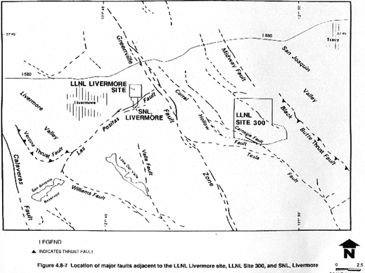
The principal faults in the vicinity of LLNL Site 300 are the Corral Hollow–Carnegie, Black Butte, and Midway faults (Figure 4.8-7). These faults are described in Appendix I. The active Carnegie fault of the Corral Hollow–Carnegie fault zone crosses the southern portion of the site (Carpenter et al., 1991). No significant recorded earthquakes have occurred on any of the local faults.
Seismic Hazards
Ground Motion. The region surrounding LLNL Site 300 has experienced strong ground shaking during historic earthquakes. In 1906 the Great San Francisco Earthquake (magnitude greater than 8) on the San Andreas fault produced structural damage a few kilometers west of LLNL Site 300 (Nason, 1982). Potential sources for future ground motion at LLNL Site 300 include major regional faults such as the San Andreas, Hayward, and Calaveras, as well as smaller faults including Greenville, Las Positas, Corral Hollow–Carnegie, Black Butte, and Midway.
A seismic hazard analysis of LLNL Site 300 produced hazard curves that display peak horizontal ground acceleration versus return period for two locations within LLNL Site 300 (TERA Corporation, 1983). The two locations were the Building 854 Complex near the western boundary of the site and the Building 834–836 Complex near the eastern boundary. Peak ground accelerations corresponding to return periods of 500, 1000, and 5000 years were calculated at 0.32g, 0.38g, and 0.56g for the Building 854 Complex and 0.28 g, 0.34 g, and 0.51 g for the Building 834–836 Complex (TERA Corporation, 1983).
Using another approach (described in Appendix I), the largest ground motions produced at the Building 854 Complex are from a magnitude 6.5 on the Corral Hollow–Carnegie fault zone at a distance of 1.4 km. Average peak horizontal ground accelerations from various mean and standard deviation relations range from 0.53 to 0.82g (Table I-6, in Appendix I). The ground motions at the Building 834–836 Complex, located in the eastern portion of the site, are greatest when considering a magnitude 6.6 earthquake on the Black Butte fault at a distance of 2.4 km. Average values of peak horizontal ground acceleration range from 0.59 to 0.91g (Table I-7; Appendix I).
Larger earthquakes on more distant faults such as the San Andreas do not significantly affect the hazard estimation.
Surface Faulting. There is a potential for surface faulting at LLNL Site 300. The areas adjacent to the active Carnegie fault could experience ground deformation should a major earthquake occur on the fault. A 10- to 13- ft (3- to 4-m)-wide zone of faulting is present in Holocene and late Pleistocene deposits near the Carnegie fault, attesting to the potential for surface rupture. In addition to the principal Holocene strike-slip Carnegie fault strand, two subsidiary faults could potentially produce minor amounts of surface rupture (Dugan et al., 1991). The only structures located adjacent to the Holocene strand of the Carnegie fault and, therefore, subject to the hazard of surface faulting, are Buildings 899A and 899B at the pistol range. However, these two structures contain no hazardous or radiological materials and have very low occupancies.
Liquefaction. LLNL Site 300 is underlain almost entirely by Tertiary bedrock, which is nonliquefiable. The Quaternary alluvium at the site is limited to generally unsaturated Pleistocene gravel-bearing terrace deposits above Corral Hollow and minor amounts of younger alluvium in canyon bottoms (Raber and Carpenter, 1983). Based on the presence of bedrock beneath LLNL Site 300, and the age, composition, and unsaturated condition of the terrace deposits, the potential for liquefaction at LLNL Site 300 is low.
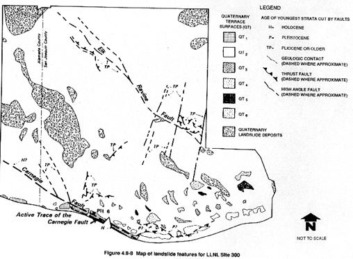
Seismically Induced Landslides. Numerous ancient landslides are located at LLNL Site 300 with the largest landslide covering approximately 1.4 sq km (see Figure 4.8-8). The potential for seismically induced landslides at LLNL Site 300 still exists. The potential for slope instability is greater on northeast-facing slopes that have strata of the Cierbo Formation exposed. Buildings 825, M825, 826, M51, 847, 851A, 851B, 854, 855, and 856 are located on old landslides. The potential for ground deformation at these buildings, located on landslide deposits, is considered to be moderate to high.
Demand Criteria for EIS/EIR
Values for maximum ground acceleration at both LLNL Site 300 locations for return periods of 500, 1000, and 5000 years are 0.5g, 0.6g, and 0.8g, respectively. These values are listed in Table 4.8-1, where they can be compared with the results of the previous ground motion hazard study as well as the present DOE seismic design criteria for LLNL Site 300.
The demand criteria, which are the same values used as the EIS/EIR demand capacity for the LLNL Livermore site and SNL, Livermore, are more conservative than those estimated in the TERA Corporation 1983 study for LLNL Site 300. Subsequent seismic hazard studies for the LLNL Livermore site have shown that the ground motion attenuation relations and the earthquake source characterization methods used previously for both the LLNL Livermore site and LLNL Site 300 by TERA Corporation underestimate the seismic hazard. In the absence of any additional seismic hazard studies, the values of 0.5g, 0.6g, and 0.8g are considered to be appropriate as peak ground accelerations for LLNL Site 300.
Nonseismically Induced Landslides
LLNL Livermore Site and SNL, Livermore
At the LLNL Livermore site and SNL, Livermore facilities there is generally little potential for nonseismically induced landslides because the sites are situated on gently sloping to nearly flat topography. The exception to this is the extreme south end of SNL, Livermore, where a canyon in the hillside has been used as a landfill and subsequently paved over. The hillside surrounding this canyon consists of moderately to weakly consolidated sand and gravel, and colluvial and alluvial terrace deposits. The hill has been mapped as showing extensive evidence of mass movement (Nilsen, 1972). If the walls of the canyon surrounding the Navy Landfill Site have steepened, there is an increased chance of slope failure during wet years.
LLNL Site 300
At LLNL Site 300, the topography ranges from gently sloping to nearly vertical in places, and numerous landslide features have been mapped (see Figure 4.8-8). The potential for nonseismically initiated landslides is great along the canyon walls, especially where soils consist of deep loams and clay loams. During periods of extended wet weather the saturated soils can become structurally weakened and expand, with resulting slope failure. If slopes are made steeper by road cutting or building excavation, the potential for localized slope instability greatly increases. If a particular location has historic evidence of slope failure (presence of landslide deposits and colluvium), the probability of a failure in the future is greatly increased.
Table 4.8-1 Ground Motion Hazard Estimates, Design Criteria, and EIS/EIR Demand Criteria Expressed as Peak Horizontal Ground Acceleration (g)a
| Source | Average Return Period (years) | ||||||||
| LLNL Livermore Site and SNL, Livermore | LLNL Site 300 Complex 854 | LLNL Site 300 Complex 834/836 | |||||||
| 500 | 1000 | 5000 | 500 | 1000 | 5000 | 500 | 1000 | 5000 | |
| Ground Motion Hazard Estimates | |||||||||
| Tera Corporation (1983) | 0.41 | 0.48 | 0.68 | 0.32 | 0.38 | 0.56 | 0.28 | 0.34 | 0.51 |
| Woodward-Clyde Consultants (1984) and Geomatrix Consultants (1985) | 0.49 | 0.58 | 0.79 | N/A | N/A | N/A | N/A | N/A | N/A |
| Geomatrix Consultants (1990) | 0.57 | 0.68 | 0.98 | N/A | N/A | N/A | N/A | N/A | N/A |
| Geomatrix Consultants (1991) | 0.51 | 0.61 | 0.88 | N/A | N/A | N/A | N/A | N/A | N/A |
| Seismic Design Criteria (1980 — 1989) Criteria | |||||||||
| LLNL (1980–1989) Criteria (Freeland, 1984)band Tokarz (1991a) | 0.25 | 0.25/ 0.5 | 0.5/ 0.8 | N/A | N/A | N/A | N/A | N/A | N/A |
| DOE (Kennedy et al., 1990) | 0.41 | 0.48 | 0.68 | 0.32 | 0.38 | 0.56 | 0.28 | 0.34 | 0.51 |
| LLNL Proposed (Coates, 1991) | 0.47 | 0.57 | 0.82 | N/A | N/A | N/A | N/A | N/A | N/A |
| Seismic Demand Criteria for 1991 EIS/EIR | |||||||||
| WESTON (1991a) | 0.5 | 0.6 | 0.8 | 0.5 | 0.6 | 0.8 | 0.5 | 0.6 | 0.8 |
a 1.0g = acceleration due to gravity.
b The values of 0.25g/0.5g, and 0.5g/0.8g
were required by the referenced criteria for all new designs and/or
modifications of General/Low Hazard, Moderate Hazard, and High Hazard
facilities, respectively. These values were not developed specifically to
reflect the 500-, 1000-, and 5000-year return periods.
N/A = Not applicable (i.e., study did not include this site).
|
NEWSLETTER
|
| Join the GlobalSecurity.org mailing list |
|
|
|