


4.13 TRAFFIC AND TRANSPORTATION
This section presents evaluations of both onsite and offsite traffic conditions at the LLNL Livermore site, LLNL Site 300, and SNL, Livermore (TJKM Transportation Consultants, 1992). Existing traffic conditions in the project vicinity are summarized below. This section also includes a description of the Livermore and Tracy municipal airports. More detailed information on both traffic and transportation issues can be found in Appendix K.
4.13.1 Regional and Local Circulation System
LLNL Livermore Site and SNL, Livermore
Due to the proximity of the two sites, and the fact that some LLNL Livermore site personnel park at SNL, Livermore, it was considered infeasible to conduct separate traffic analyses for the two sites. The respective increment of traffic (i.e., vehicle trips per day) contributed by each Laboratory was determined based on existing and projected personnel numbers at each facility. However, while it is acknowledged that the two Laboratories are distinct operations managed and operated by different contractors, the evaluation of Laboratory-related traffic effects on the local circulation network was conducted for the two Laboratories combined, due to the difficulty in distinguishing between LLNL- and SNL, Livermore-related traffic at a given intersection or roadway segment. A separate analysis was performed for LLNL Site 300 because of its distance from the other Laboratory sites.
Site Access
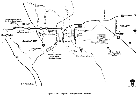
As shown in Figure 4.13-1, regional access to the LLNL Livermore site and SNL, Livermore is primarily from Interstate 580 (I-580) by the Vasco Road and Greenville Road interchanges. The LLNL Livermore site is accessed by security gates along Vasco Road, East Avenue, and Greenville Road. SNL, Livermore is accessed via security gates along East Avenue. A description of the geometrics (i.e., features of the roadway design) of the various roadways in the vicinity of the LLNL Livermore site and SNL, Livermore is provided in Appendix K.
Regional Transportation Improvements
There are currently two regionally important transportation projects proposed or underway. They are the extension of the Bay Area Rapid Transit District (BART) rail transit to Dublin and Pleasanton, and the proposed Mid-State Tollway project (see Figure 4.13-1). More information regarding these transportation projects is included in Appendix K. Although both projects would have an effect on Tri-Valley traffic, neither is in the immediate vicinity of the LLNL Livermore site and SNL, Livermore. Consequently, neither the BART extension nor the tollway project is expected to have a significant effect on traffic at the key intersections or roadway segments studied in the traffic analysis.
LLNL Site 300
Site Access
Regional access to LLNL Site 300 is primarily from I-580 by the Corral Hollow Road interchange (see Figure 4.13-1). LLNL Site 300 is accessed from a series of two security gates at the main entrance off Corral Hollow Road. Corral Hollow Road, which becomes Tesla Road at the Alameda County/San Joaquin County line, runs in a generally east-west direction between the City of Livermore and I-580 in San Joaquin County. Thus, this roadway provides access between LLNL Site 300 and the LLNL Livermore site, although access is also provided via I-580 between the sites. A description of the geometrics of Tesla Road/Corral Hollow Road is provided in Appendix K.
4.13.2 Local Existing Traffic Conditions
Traffic Generation and Distribution—LLNL Livermore Site and SNL, Livermore
Existing 24-hour average daily traffic counts at all entrances to the Laboratory sites were collected (TJKM Transportation Consultants, 1992). Average daily traffic is defined as the total number of cars passing over a segment of roadway, in both directions, on a typical day. In this report, all average daily traffic volumes are two-way counts at the indicated locations. Average daily traffic for the LLNL Livermore site and SNL, Livermore is estimated to be approximately 23,960 and 3100 vehicle trips, respectively.
The estimated distribution of the LLNL Livermore site trips is as follows: 32 percent at Westgate Drive, 23 percent at Southgate Drive, 8 percent at West Perimeter Drive, 14 percent at Mesquite Way, 20 percent at East Gate Drive, and 3 percent at the truck entrance on East Avenue. The SNL, Livermore trip distribution at its three access gates is as follows: 43 percent at the west gate, 29 percent at the east gate (Thunderbird Lane), and 28 percent at the main gate.
Based on the actual 24-hour average daily traffic counts conducted in 1991 to determine total personnel trips, the average number of trips per person for the LLNL Livermore site and SNL, Livermore is approximately two trips per person per day (TJKM Transportation Consultants, 1992).
Existing peak hour traffic counts show that LLNL Livermore site and SNL, Livermore traffic contributes a high proportion of the vicinity's daily traffic in the a.m. peak hour (i.e., the peak traffic period in the morning). The existing trip distribution patterns show the Vasco Road corridor to be the most heavily utilized. The distribution of the a.m. peak-hour traffic from the Laboratories is as follows: 38 percent on Vasco Road, 28 percent on Greenville Road towards the I-580 freeway, 30 percent on East Avenue, 2 percent on Patterson Pass Road, and 2 percent on Greenville Road (towards Tesla Road).
Traffic Generation and Distribution—LLNL Site 300
The estimated average daily traffic volume at LLNL Site 300 is approximately 700 vehicles per day. The distribution of LLNL Site 300 traffic on Corral Hollow Road is estimated to be 60 percent to the east towards Tracy and 40 percent to the west towards Livermore.
The estimated average daily traffic volume at LLNL Site 300 is based on an average trip rate of 3.5 trips per person per day, which was derived from actual 24-hour average daily traffic counts conducted at the LLNL Site 300 main entrance (TJKM Transportation Consultants, 1992). It should be noted that this trip rate differs from the trip rate calculated for the LLNL Livermore site and SNL, Livermore. Both average trip rates were calculated from actual traffic counts at the respective sites. The lower average trip rate for the LLNL Livermore site and SNL, Livermore is partially due to the current ridesharing and public transportation opportunities available to these personnel.
Average Daily Traffic Volumes of Key Roadways—LLNL and SNL, Livermore
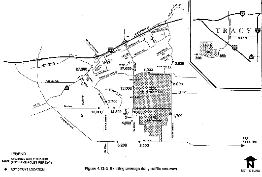
A description of the geometrics of the 18 key roadway segments evaluated in the recent traffic study (TJKM Transportation Consultants, 1992) is included in Appendix K. Existing average daily traffic volumes and traffic count locations for the 18 roadway segments are shown in Figure 4.13-2.
Peak-Hour Conditions at Key Intersections—LLNL and SNL, Livermore
The criterion for evaluating traffic conditions in the vicinity of the LLNL Livermore site and SNL, Livermore is that used by the City of Livermore: a congestion condition exceeding a peak-hour volume-to-capacity (V/C) ratio of 0.85 per average day at a major intersection is considered unacceptable. A V/C ratio of 0.85 corresponds to level of service (LOS) D (LOS D includes the range of V/C ratios from 0.81 to 0.90). LOS describes the operating conditions that occur on a lane or roadway when accommodating various traffic volumes.
LOS is described by a letter rating system from A to F, with LOS A indicating stable flow and little or no delays, and LOS F indicating jammed conditions and excessive delays. In San Joaquin County (for evaluation of LLNL Site 300 traffic conditions), the existing LOS C standard is used (LOS C encompasses the range of V/C ratios from 0.71 to 0.80). Traffic congestion conditions exceeding LOS C (LOS D and worse) are considered to be unacceptable. Appendix K discusses LOS ratings and also provides a discussion of the relationship between V/C ratio and LOS.
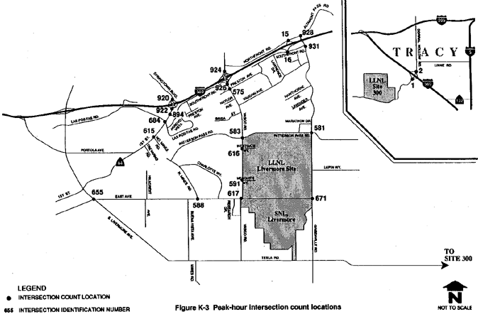
Both a.m. and p.m. peak-hour traffic conditions were examined at 16 key intersections and the I-580 interchanges at Vasco Road and Greenville Road near the LLNL Livermore site and SNL, Livermore, and at the I-580 interchange at Corral Hollow Road near LLNL Site 300. Figure K-3 in Appendix K identifies the locations of the study intersections. The "peak hour" is defined as the four busiest consecutive 15-minute periods, in the morning and in the evening, and typically occurs during commute periods.
Intersection operations were evaluated using a method of intersection capacity analysis known as the Intersection Capacity Utilization method. A more detailed description of this methodology is provided in Appendix K. As discussed earlier in this section, peak-hour intersection conditions are reported as V/C ratios, and LOS are reported using a letter rating system and corresponding descriptions of intersection traffic flow, delay, and maneuverability. This rating system is also described in Appendix K.
Table 4.13-1 presents existing a.m. and p.m. peak-hour V/C ratios and LOS ratings for each study intersection. As shown in this table, two study intersections currently operate at levels of service that exceed a V/C ratio of 0.85 (LOS D) in the p.m. peak hour, including: First Street at Las Positas Road and First Street at North Mines Road. A design study is currently underway for the First Street area in the City of Livermore to widen First Street (from north of North Mines Road to the I-580 eastbound on-/off-ramps) from the existing two lanes to four or six lanes (TJKM Transportation Consultants, 1992). If implemented, these improvements would improve the LOS of study intersections along First Street at Las Positas Road and North Mines Road to acceptable city standards, as well as further improve the LOS at First Street and Southfront Road (TJKM Transportation Consultants, 1992).
Additional information regarding existing traffic conditions at study intersections is found in Appendix K.
4.13.3 Study Area Traffic Accident History
LLNL Livermore Site and SNL, Livermore
A review of Statewide Integrated Traffic Records System accident reports was made for 1988, 1989, and 1990 to determine the accident history at intersections in the vicinity of the LLNL Livermore site and SNL, Livermore. The results of the analysis indicated that three Vasco Road intersections (at Preston Avenue, Brisa Street and Vaughn Avenue) have experienced relatively high accident rates and have already been targeted for safety improvements by the City of Livermore. The planned improvements are described in Appendix K.
Additional improvements (described in the previous section) contemplated by Caltrans and the City of Livermore for the First Street corridor between North Mines Road and Southfront Road are expected to improve traffic operations and reduce accidents at these intersections. No further analysis has been conducted for this EIS/EIR for the identified accident areas.
LLNL Site 300
Accidents in the vicinity of LLNL Site 300 occur between I-580 and the Alameda/San Joaquin County Line at a rate of approximately four accidents per year. There is no recurring location for these accidents, which consist primarily of property damage caused by single-driver accidents.
Table 4.13-1 Existing Levels of Service at Key Intersections
| Intersection ID Number (Refer to Figure K-3) | Intersection Location | A.M. Peak Hour | P.M. Peak Hour | ||
| V/C | LOS | V/C | LOS | ||
| 1 | I-580 SB Off-Ramp at Corral Hollow Road | 0.20 | A | 0.24 | A |
| 2 | I-580 NB Off-Ramp at Corral Hollow Road | 0.23 | A | 0.18 | A |
| 920 | I-580 WB Off-Ramp at Springtown Boulevard | 0.85 | D | 0.84 | D |
| 922 | I-580 EB Off-Ramp at First Street | 0.75 | C | 0.84 | D |
| 894 | First Street at Southfront Road | 0.84 | D | 0.67 | B |
| 684 | First Street at Los Positas Road | 0.84 | D | 0.89 | D |
| 615 | First Street at North Mines Road | 0.82 | D | 0.87 | D |
| 655 | East Avenue at S. Livermore Avenue | 0.57 | A | 0.66 | B |
| 588 | East Avenue at North Mines Road | 0.58 | A | 0.69 | B |
| 617 | East Avenue at Vasco Road | 0.61 | B | 0.62 | B |
| 671 | East Avenue at Greenville Road | 0.34 | A | 0.42 | A |
| 924 | I-580 WB Off-Ramp at Vasco Road | NA | NA | NA | NA |
| 926 | I-580 EB Off-Ramp at Vasco Road | NA | NA | NA | NA |
| 575 | Vasco Road at Preston Avenue | 0.62 | B | 71 | C |
| 583 | Vasco Road at Patterson Pass Road | 0.70 | BA | 0.62 | B |
| 616 | Vasco Road at Westgate Drive | 0.47 | A | 0.53 | A |
| 591 | Vasco Road at Mesquite Way | 0.41 | A | 0.47 | A |
| 16 | I-580 EB Off-Ramp at Southfront Road | NA | NA | NA | NA |
| 15 | I-580 WB Off-Ramp at Northfront Road | NA | NA | NA | NA |
| 928 | Greenville Road at Altamont Pass Road | 0.70 | B | 0.35 | A |
| 931 | Greenville Road at Southfront Road | 0.70 | B | 0.43 | A |
| 581 | Greenville Road at Patterson Pass Road | 0.75 | C | 0.60 | A |
NB = northbound; WB = westbound; EB = eastbound; SB = southbound.
V/C =
volume-to-capacity ratio.
LOS = level of service, ranging from A (stable
flow-very slight or no delay) to F (forced flow-excessive delay).
NA = not
applicable; no intersections exist at this interchange at the present time.
| V/C | LOS | V/C | LOS |
| 0.00–0.60 | A | 0.81–0.90 | D |
| 0.61–0.70 | B | 0.91–1.00 | E |
| 0.71–0.80 | B | 1.00+ | F |
Source: TJKM Transportation Consultants, 1992.
4.13.4 Onsite Circulation and Parking
LLNL Livermore Site
External Access
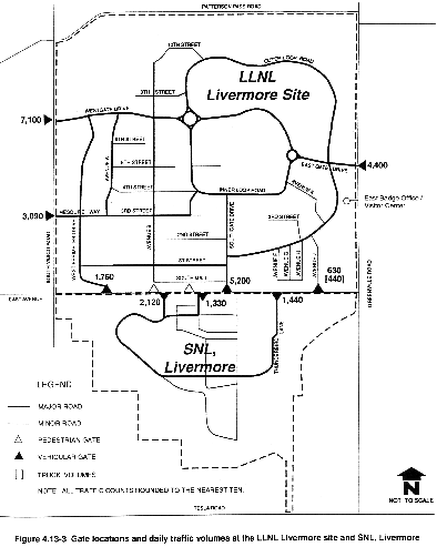
Vehicle access to the LLNL Livermore site is currently provided at six locations (see Appendix K for more detailed discussion on these access points). Existing inbound and outbound traffic volumes at these gates are shown in Figure 4.13-3. Also shown in Figure 4.13-3 are the pedestrian gates on East Avenue that provide access between the LLNL Livermore site and SNL, Livermore.
Onsite Street Network
The existing internal circulation network of the LLNL Livermore site is also depicted in Figure 4.13-3 (Appendix K provides a more specific description of onsite streets). A 1986 traffic circulation and access study for the LLNL Livermore site identified and recommended mitigations for onsite access and circulation problems (TJKM Transportation Consultants, 1986). Appendix K provides a summary of the recommendations from this study.
In recent (1991) discussions with LLNL Facilities Planning staff, two existing onsite circulation problems were identified (TJKM Transportation Consultants, 1992): (1) a.m. peak-hour queuing and delays at the intersections of Westgate Drive and Avenues A and B; and (2) p.m. peak-hour queuing in the eastbound exiting lanes at Eastgate Drive. Peak-hour turning movement counts were taken at all three intersections. Based on these counts and on field observation, traffic currently has no difficulty moving through the Westgate Drive intersections during the a.m. peak period, and queuing is minimal (TJKM Transportation Consultants, 1992). Growth in the northwest quadrant may create adverse conditions in the future.
Based on a recent (1991) p.m. peak-hour turning movement count, the intersection of Greenville Road at Eastgate Drive/Lupin Way is approaching design capacity. This results in long delays for the eastbound-to-northbound left-turn movement out of the LLNL Livermore site. The reserve capacity for this movement is 24 vehicles. Reserve capacity is the unused capacity of a vehicle travel lane (i.e., the number of additional vehicles that could make a particular turning movement before that movement reaches capacity). Although the intersection does not yet meet peak-hour traffic signal warrants, future onsite traffic conditions may require additional analysis at this location.
Onsite Parking
The latest parking demand was evaluated by LLNL in 1988 in a Parking Master Plan (LLNL, 1988). Utilizing this information as a base, and updating the parking demand based on the current number of personnel, the current parking stall deficit is 923 onsite personnel parking stalls. There are also 962 assigned government vehicles located onsite, including those assigned to the Protective Force Division. Based on updated estimates from the 1988 report which take into account the current number of government vehicles and stalls onsite, a deficit of 107 stalls is identified for government vehicles (LLNL, 1988). (See Appendix K for more details on parking calculations.)
Onsite Accident History
No accidents or Statewide Integrated Traffic Records System reports for onsite traffic accidents were reviewed for this traffic analysis. According to the LLNL Planning and Development Department and the Protective Force Division, the majority of onsite accidents take place in the onsite parking lots. Parking lot accidents are not typically mitigated by physical street improvements. It should be noted that although the security division reported approximately seven serious onsite traffic accidents during the 3-year evaluation period, there were not enough accidents occurring at any one location to prompt a trend analysis.
LLNL Site 300
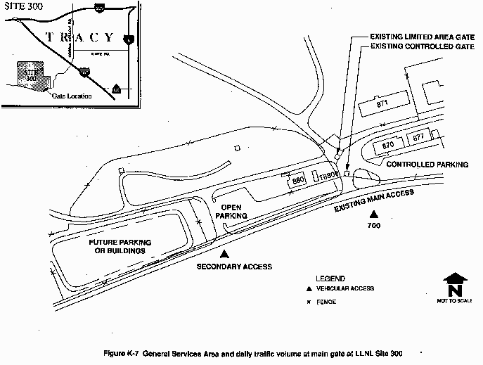
Access to LLNL Site 300 is through a series of two security gates at the main entrance on the north side of Corral Hollow Road. The current average daily volume count at the main gate is 700 vehicles. Vehicular access around LLNL Site 300 is limited to parking lots and roadways in the southeast corner of the site near the General Services Area. There are 185 parking stalls designated at LLNL Site 300, including those used by government vehicles. On an average day, there are 50 to 60 empty stalls; therefore, adequate parking is available. Figure K-7 in Appendix K depicts the access and circulation in the General Services Area. Access to roadways in the northern limited area is restricted.
Because of speeding vehicles on Corral Hollow Road, access problems have been identified at the LLNL Site 300 main gate area. Improvements including reconfiguration of the internal gate structure and parking areas near the main entrance, and relocation of the main entrance slightly to the west of its present location, are currently underway. Construction began in July 1992 and is projected to be completed by November 1992.
SNL, Livermore
SNL, Livermore personnel, restricted from driving on the SNL, Livermore facility, must park in lots adjacent to East Avenue or near the Combustion Research Facility on Thunderbird Lane. LLNL personnel may also park in these lots. There are a total of 2000 personnel parking stalls in these lots. Additional parking stalls for government vehicles are provided within the SNL, Livermore grounds. No parking stall deficiencies are currently identified at SNL, Livermore. Existing 1991 parking lot driveway counts for SNL, Livermore are shown on Figure 4.13-3. As a result of the onsite driving restrictions at SNL, Livermore, no evaluation was made of its onsite circulation or traffic accident history.
4.13.5 Alternate Modes of Transportation
Public transit service is available directly to the LLNL Livermore site and SNL, Livermore by the local Wheels bus service and by BART Express. Appendix K provides more information regarding routes for these services.
LLNL Livermore Site
LLNL conducts a ridesharing program as part of its in-house energy management program that began in 1976. A ridesharing program goal is to reduce the onsite traffic and parking problems at the LLNL Livermore site facility. There is a designated onsite rideshare coordinator who maintains a database of individuals participating in the program which currently consists of more than 474 carpools with an estimated 700 riders, and 43 vanpools with an estimated 565 riders (LLNL, 1991g). The Stockton Metropolitan Transit District also provides six buses (three from Manteca, two from Stockton, and one from Tracy) driven by LLNL drivers, offering ridesharing opportunities to approximately 115 LLNL Livermore site and SNL, Livermore personnel from outlying cities.
Taxis (i.e., on-call shuttlevans) and energy-efficient carts provide onsite transportation alternatives within the LLNL Livermore site. As of 1991, the taxi fleet consisted of 9 taxis (12 to 15 passengers), 3 buses (27 to 37 passengers), 2 station wagons, and 1 van (LLNL, 1989g). More than 700 Laboratory bicycles are also located throughout the facility for onsite travel. It is estimated that the total use of these bicycles amounts to more than 500 miles per day (LLNL, 1991g).
LLNL Site 300
There are currently 26 carpools with an estimated 49 riders, and 2 vanpools with an estimated 14 riders operating at LLNL Site 300. Parking stalls are reserved for these vehicles onsite. There are also 155 government vehicles assigned to LLNL Site 300. Currently there is no public bus service to the site, although a shuttle service is available between the LLNL Livermore site and LLNL Site 300.
SNL, Livermore
Although there is no formal ridesharing program at SNL, Livermore, an informal rideshare matching program, facilitated through a weekly newsletter, supports two vanpools with an estimated 19 riders and 20 carpools with an estimated 60 riders. SNL, Livermore personnel can also participate in the ridesharing opportunities provided by the Stockton Metropolitan Transit District buses discussed above. Onsite transportation is provided via approximately 200 bicycles and 131 gasoline-powered and electrically powered carts. Fifty government vehicles are assigned for use by specific SNL, Livermore departments onsite, including Protective Services. A bus stop turnaround, utilized by the Wheels and BART Express bus services, is provided onsite.
4.13.6 Aircraft Operations
Some passengers and materials bound to and from LLNL and SNL, Livermore move through the Livermore Municipal Airport, which provides service to the LLNL Livermore site and SNL, Livermore. LLNL maintains an aircraft with an associated service facility at the Livermore Municipal Airport. Materials also move through the Tracy Municipal Airport, primarily servicing LLNL Site 300. In addition, both Laboratories occasionally receive and ship materials via flight operations at the Alameda Naval Air Station, near Oakland, and Castle Air Force Base, near Merced, California.
Livermore Municipal Airport
Located south of I-580, just within the western boundary of the City of Livermore, the Livermore Municipal Airport occupies approximately 400 acres and has been in operation at the existing location since 1965. Based on air traffic counts taken in the early 1970s, the city constructed an FAA Air Traffic Control Tower in 1973, installing an instrument landing system 6 years later.
LLNL, then known as the University of California Radiation Laboratory, Livermore Site, began contract flight operations at the airport in 1954 at a previous location. Subsequently, LLNL began operating and housing a Fairchild F-27F aircraft at the airport in 1968. With a 40-passenger capacity, the LLNL aircraft is one of the largest aircraft regularly using the airport (City of Livermore, 1975).
For the 12 months preceding February 1991, the airport logged a total of 233,405 flight operations (takeoffs and landings); this compares to 227,952 operations from February 1989 to February 1990, and to 209,391 operations for the 12-month period prior to that (Maestas, 1991). The annual LLNL-related flight operations at the Livermore Municipal Airport are estimated to be 520 (approximately 10 takeoffs and landings per week).
Tracy Municipal Airport
Located approximately 3 miles southwest of the City of Tracy, the Tracy Municipal Airport occupies about 309 acres, less than half of which has been developed for aviation use. Constructed on city property by the U.S. Army Air Corps in 1943 as a training base during World War II, the airport was transferred by the Army to civilian use in 1946 (City of Tracy, 1975).
The total annual operations (takeoffs and landings) at the airport, estimated from fuel sales and observations of based aircraft, is approximately 56,750. A new 20-year master plan for the Tracy Municipal Airport is in preparation (Pellegrino, 1991a, 1991b). LLNL-related flights were estimated to be 32 in 1990: 12 flights for the LLNL plane plus 20 flights by Ross Airlines, a DOE contract air service.
|
NEWSLETTER
|
| Join the GlobalSecurity.org mailing list |
|
|
|