


APPENDIX K TRAFFIC AND TRANSPORTATION
K.1 INTRODUCTION
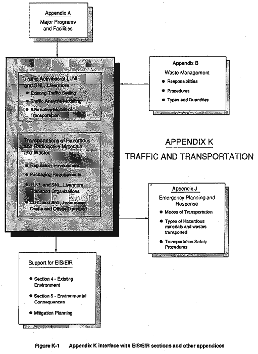
This appendix includes additional information supporting the impacts analyses in the traffic and transportation sections (see sections 4.13 and 5.1.11) of the EIS/EIR. It provides a more extensive and detailed discussion of traffic-related and transportation activities at LLNL and SNL, Livermore. It also addresses the general and specific requirements for moving hazardous and radioactive material and wastes both onsite and offsite (see sections 4.15 and 5.1.13). Figure K-1 describes the relationship between Appendix K and other portions of the EIS/EIR.
For the traffic analysis, section K.2 of the appendix provides additional information about existing roadway networks servicing the LLNL and SNL, Livermore sites; it also describes the analytical methodologies and modeling used to assess traffic conditions. The section also discusses the various modes of public transportation available in the region of LLNL and SNL, Livermore.
For the transportation analysis, section K.3 of the appendix describes the onsite and offsite movement, via ground and air, of hazardous and radioactive materials and wastes at LLNL and SNL, Livermore. It briefly discusses the regulatory environment for these activities, the organizations within LLNL and SNL, Livermore responsible for movement of these materials and wastes, the procedures followed to ensure safe movement of these materials and wastes, and quality assurance and quality control activities.
Because a number of related activities directly affect the safe transport of hazardous materials and wastes, this section includes a brief discussion of transportation packaging, labeling, marking, vehicle inspection and placarding, driver qualifications and training, and transportation routing for offsite shipment of hazardous materials and wastes.
K.2 TRAFFIC ACTIVITIES AT LLNL AND SNL, LIVERMORE
This section presents information from a traffic study conducted on LLNL and SNL, Livermore traffic activities for this EIS/EIR (TJKM Transportation Consultants, 1992). The study evaluated onsite and offsite traffic conditions for LLNL and SNL, Livermore, relevant local circulation policies, and existing and future traffic conditions in the project vicinity. This information was used to evaluate the EIS/EIR proposed action and its alternatives.
Due to the proximity of the two sites, and the fact that some LLNL Livermore site personnel park at SNL, Livermore, it was not considered feasible to conduct separate traffic analyses for the two sites. The respective increment of traffic (i.e., vehicle trips per day) contributed by each Laboratory was determined based on existing and projected personnel numbers at each facility. However, while it is acknowledged that the two Laboratories are distinct operations managed and operated by different contractors, the evaluation of Laboratory- related traffic effects on the local circulation network was conducted for the two Laboratories combined, due to the difficulty in distinguishing between LLNL- and SNL, Livermore-related traffic at a given intersection or roadway segment. A separate analysis was performed for LLNL Site 300 due to its distance from the other Laboratory sites.
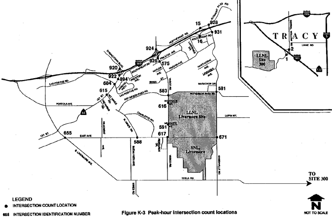
For the traffic analysis, a.m. and p.m. peak-hour traffic conditions were examined at 16 key intersections and the Interstate 580 (I-580) interchanges at Vasco Road and Greenville Road near LLNL and SNL, Livermore, and at the I-580 interchange at Corral Hollow Road near LLNL Site 300. Intersections selected for study are those located in the vicinity of the facilities that are considered critical to the flow of peak-period traffic.
In addition, existing average daily traffic counts were conducted for 18 key roadway segments that provide direct or indirect access to the Laboratories. Traffic volumes on these key roadways could be affected by project activities. A description of the geometrics of the roadway segments evaluated is provided later in this section. The geometrics of the roadways include features of the roadway design, such as roadway alignment, intersections, and interchanges.
K.2.1 Existing Traffic Setting
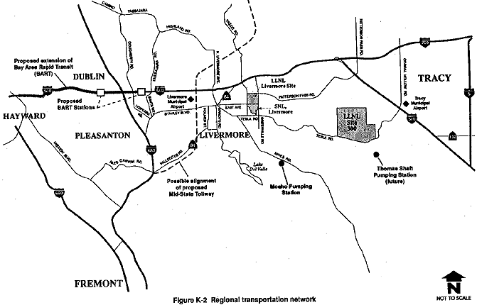
The regional and local transportation setting is shown in Figure K-2.
LLNL Livermore Site and SNL, Livermore
Regional access to the LLNL Livermore site and SNL, Livermore is gained primarily from I-580 via the Vasco Road and Greenville Road interchanges. Interstate 580 runs in an east-west direction approximately 2 miles from the northern LLNL Livermore site boundary. Interstates 880 and 680 and State Highway Route 84 lie further west of the sites. Interstates 205 and 5 lie further to the east.
The LLNL Livermore site is accessed via security gates along Vasco Road, East Avenue, and Greenville Road. SNL, Livermore is accessed via security gates along East Avenue. Existing traffic volumes at the access gates along these three roadways are presented later in this section.
LLNL Site 300
Regional access to LLNL Site 300 is primarily from I-580 via the Corral Hollow Road interchange (see Figure K-2). West of LLNL Site 300, "Corral Hollow Road" is renamed "Tesla Road," and runs in an east-west direction south of SNL, Livermore, before changing to a northwest-southeast alignment named "South Livermore Avenue," then a north-south alignment named "North Livermore Avenue." LLNL Site 300 is accessed from a series of two security gates at the main entrance off Corral Hollow Road, which are discussed later in this section. An additional access, into a parking area only, is located to the west of the main entrance off Corral Hollow Road.
K.2.1.1 Relevant Local Circulation System Policies and Regional Transportation Improvements
This section describes relevant policies from the circulation elements of applicable jurisdictions in the project vicinity. These policies generally reflect their respective standards for acceptable traffic conditions and are considered by both LLNL and SNL, Livermore in their traffic planning decisions. This section also briefly discusses important regional transportation improvements currently under construction.
City of Livermore
The Circulation Element of the Livermore Community General Plan (1989) contains the following policy pertaining to this project:
"For the purposes of development-associated traffic studies, road improvement design, and capital improvement priorities, the City shall consider a peak-hour volume-to-capacity (V/C) ratio of 0.85 for periods of 2 hours or more per average day to be the upper limit of acceptable service at major intersections in Livermore."
County of Alameda
The Traffic and Circulation Element of the Livermore-Amador Valley Planning Unit General Plan (County of Alameda, 1977) contains the following policy pertaining to this project:
"Improve Safety and Reduce Congestion. To improve the safety of and reduce the congestion on roadways through capital improvements and promotion of alternative means of transportation."
County of San Joaquin
The San Joaquin County General Plan 1995 (1976) contains a standard regarding intersection levels of service that was defined by an unpublished San Joaquin superior court decision to be level of service (LOS) C. LOS describes the operating conditions that occur on a lane or roadway when accommodating various traffic volumes. In this study, LOS is described by a letter rating system from A to F, with LOS A indicating stable flow and little or no delays, and LOS F indicating jammed traffic conditions and excessive delays. A more detailed discussion of LOS categories and how they relate to V/C ratios is provided later in this appendix. The County is in the process of updating its General Plan to include a revised traffic standard of LOS D (Islas, 1991). The new General Plan is still in a draft stage, and hearings are pending.
Regional Transportation Improvements
There are currently two regionally important transportation projects underway. They are the extension of the Bay Area Rapid Transit District (BART) rail transit to Dublin/Pleasanton, and the Mid-State Tollway project (refer to Figure K-2). BART is extending rail transit from the existing BART rail system 12 miles from the Bayfair Station (in San Leandro) to the cities of Dublin and Pleasanton. Construction is underway on this BART extension and is anticipated to be completed in 1995. The Mid-State Tollway project involves a conceptual proposal for an 85-mile tollway connecting the Fremont area with the Interstate 80 corridor near Vacaville, and the Interstate 5 corridor, via I-580, with the Interstate 80 corridor near Vacaville. These connections are proposed to occur approximately midway between Interstate 680 and Interstate 5. The Mid-State Tollway construction is projected to begin in 1994 and be completed in the late 1990s. Although both the BART extension and the Mid-State Tollway project will have significant effects on Tri-Valley area traffic, neither is in the immediate vicinity of the LLNL and SNL, Livermore facilities, and so neither project is expected to have a significant effect on the key intersections or roadway segments studied in the traffic analysis. The traffic study does not include any assumptions in the analysis derived from these proposed projects.
K.2.1.2 Standards of Significance
A standard of significance is the limit of acceptable performance at a given intersection or roadway. Exceeding this limit would constitute a significant adverse effect on the traffic network. For purposes of this EIS/EIR analysis, an impact is considered to be significant if the increment of traffic contributed by the project is substantial in relation to the existing traffic load and capacity of the roadway network, and causes a change in the V/C ratio and/or corresponding LOS to an unacceptable level. The standard of significance for evaluating traffic conditions in the vicinity of the LLNL Livermore site and SNL, Livermore is that used by the City of Livermore: future intersection congestion conditions exceeding a peak-hour V/C ratio of 0.85 per average day at major intersections are considered to be significant.
As described later in this appendix, a V/C ratio of 0.85 corresponds to LOS D (LOS D includes the range of V/C ratios from 0.81 to 0.90). For evaluation of LLNL Site 300 traffic conditions in San Joaquin County, the existing LOS C standard is used. LOS C encompasses the range of V/C ratios from 0.71 to 0.80. Traffic congestion conditions exceeding LOS C (LOS D and worse) are considered to be significant. Section K.2.2 of this appendix contains additional discussion of the relationship between LOS and V/C ratios.
In addition, a significant impact would be identified if the proposed action resulted in inadequate provision of internal parking and circulation.
K.2.1.3 Project-Related Traffic Generation and Distribution
Existing 24-hour average daily traffic counts at all entrances to the project sites were collected (TJKM Transportation Consultants, 1992). Average daily traffic is defined as the total number of cars passing over a segment of roadway, in both directions, on a typical day. In this report, all average daily traffic volumes are two-way counts at the indicated locations. The estimated average daily traffic volumes generated by the LLNL Livermore site and SNL, Livermore are approximately 23,960 vehicles per day and 3100 vehicles per day, respectively (TJKM Transportation Consultants, 1992). The distribution of the total 23,960 trips at the LLNL Livermore site is as follows: 32 percent at Westgate Drive, 23 percent at Southgate Drive, 8 percent at West Perimeter Drive, 14 percent at Mesquite Way, 20 percent at East Gate Drive and 3 percent at the truck entrance on East Avenue. The SNL, Livermore trip distribution at the three access gates is as follows: 43 percent at the west gate, 29 percent at the east gate (Thunderbird Lane) and 28 percent at the main gate.
Since some LLNL Livermore site personnel park at SNL, Livermore, it is not possible to compute the number of trips per person for each Laboratory site. The average trips per person is computed based on the total trips per person for both sites. Based on the actual 24-hour average daily traffic counts conducted in 1991 to determine total personnel trips, the average is approximately two trips per person per day. In most employment centers, the average trip rate is approximately three trips per person. The reduction in vehicle trips is due to the utilization of ridesharing and transit, which more than offsets the trips created by delivery vehicles, visitors, and midday trips by Laboratory personnel.
Existing peak-hour traffic counts show that the LLNL Livermore site and SNL, Livermore traffic contributes a high proportion of the daily traffic in the vicinity in the a.m. peak hour. The existing trip distribution patterns show the Vasco Road corridor to be the most heavily utilized. The distribution of the a.m. peak hour traffic from the Laboratories is as follows: 38 percent on Vasco Road, 28 percent on Greenville Road towards the I-580 freeway, 30 percent on East Avenue, 2 percent on Patterson Pass Road, and 2 percent on Greenville Road (towards Tesla Road) (TJKM Transportation Consultants, 1992).
The average daily traffic volume at LLNL Site 300 is estimated to be approximately 700 vehicles per day. As with the LLNL Livermore site and SNL, Livermore, this traffic volume was derived from actual 24-hour average daily traffic counts conducted at the main entrance. Based on this daily traffic volume and the current number of personnel at LLNL Site 300, an average trip rate of approximately 3.5 trips per person per day is calculated. It should be noted that this trip rate differs from the trip rate calculated for the LLNL Livermore site and SNL, Livermore. As noted earlier, both average trip rates were calculated from actual traffic counts at the respective sites. The distribution of traffic on Corral Hollow Road is estimated at 60 percent towards Tracy and 40 percent towards Livermore.
K.2.1.4 Peak-Hour Conditions at Key Intersections
Intersection operations were evaluated using a method of intersection capacity analysis known as the Intersection Capacity Utilization method. This is a method for analyzing intersection operating conditions by calculating a V/C ratio for each governing "critical" movement during a traffic signal phase. The V/C ratio for each phase is summed with the others at the intersection to produce an overall V/C ratio for the intersection. The V/C ratio represents the percent of the intersection capacity utilized. A more detailed description of this methodology is provided later in this section. Peak-hour intersection conditions are reported as V/C ratios. The peak hour is defined as the four busiest consecutive 15-minute periods, in the morning and in the evening. These typically occur during the a.m. and p.m. commute periods. Levels of service are reported using a letter rating system and corresponding descriptions of intersection traffic flow, delay, and maneuverability. This rating system is also described later in this section. Calculation sheets for existing intersection conditions are presented in the traffic study prepared for this EIS/EIR (TJKM Transportation Consultants, 1992).
Selected study intersection locations in the vicinity of all three project sites (LLNL Livermore site, LLNL Site 300, and SNL, Livermore) are shown in Figure K-3 and are listed in Table K-1. Table K-1 presents existing a.m. and p.m. peak-hour V/C ratios and level of service ratings for each study intersection.
Vasco Road
Measures to improve current operating conditions along Vasco Road have been implemented recently in conjunction with other projects in the vicinity. For purposes of the traffic study, these and any other approved and funded improvements were considered to exist (as of September 1992) as part of the baseline conditions for evaluating intersection levels of service (TJKM Transportation Consultants, 1992). A discussion of the assumed improvements as of September 1992 is provided below.
Recent improvements to widen Vasco Road to three or four lanes (with appropriate turn lanes) between Patterson Pass Road and East Avenue have improved the volume-to-capacity ratios at the intersections of Vasco Road with Westgate Drive and East Avenue to acceptable city standards. These improvements were completed in 1991. Improvements at the four Vasco Road intersections (Patterson Pass Road, Westgate Drive, Mesquite Way, East Avenue) included widening the northbound approach to accommodate two through lanes with separate left- and right-turn lanes. Other improvements at these intersections that now exist include the following:
- Patterson Pass Road. Other than the northbound approach, all intersection approaches retain the existing lane configuration.
- Westgate Drive. The southbound approach was widened to accommodate two through lanes and two southbound-to-eastbound left-turn lanes, each 350 ft long, replacing a single 1000-ft-long left-turn lane.
- Mesquite Way. When development on the west side takes place, this intersection will become a full, four-way intersection with appropriate turn lanes. Recent interim improvements included the installation of a traffic signal and widening the southbound approach to include two southbound-to-eastbound left-turn lanes and one through lane.
- East Avenue. The southbound approach now includes two southbound-to-eastbound left-turn lanes.
I-580/Vasco Road Interchange
This interchange does not currently contain intersections involving either of the two ramps serving the major flow of Laboratories-related traffic—the northbound-to-westbound on-ramp and the eastbound-to-southbound off-ramp. These movements are currently served by a free-flowing loop on-ramp and a free-flowing diagonal off-ramp, respectively. The configuration of these ramps does not lend itself to conventional peak-hour intersection evaluation, due to the free-flowing nature of the traffic movements. The 1991 a.m. peak hour turning movement counts conducted at the I-580/Vasco interchange showed the eastbound to southbound movement at the intersection of I-580 eastbound off-ramp and Vasco Road to be approximately 1400 vehicles. Thus, the eastbound off-ramp is operating near capacity. The eastbound off-ramp is yield-controlled and is currently opposed by approximately 650 southbound vehicles near the intersection of Vasco Road and I-580 eastbound off-ramp in the a.m. peak hour. Field observations indicated that the eastbound to southbound off-ramp traffic is able to maneuver without much difficulty since the southbound traffic are utilizing the inner lane, thus leaving the curb lane free. Conversations with the City of Livermore engineer indicated that occasionally congestion does occur in this area, but only at the peak 15-minutes interval (TJKM Transportation Consultants, 1992). Overall, traffic operation is acceptable.
Observations at the I-580 westbound off-ramp were also made by TJKM Transportation Consultants. Currently, the existing traffic from the I-580 westbound loop off-ramp to southbound on Vasco Road is yield controlled. Field observations indicate that the westbound loop off-ramp traffic is able to execute the movement without undue delays.
In the future, in order to accommodate growth in industrial areas north of the Laboratories, in residential areas north of I-580, and general growth in eastern Contra Costa County to the north, the Vasco Road interchange may need to be improved. Although no specific improvement project is currently planned or funded, such improvements would likely involve the construction of signalized westbound and eastbound off-ramps and the provision of loop on-ramps in the northeast and southwest quadrants of the interchange.
I-580/Greenville Road Interchange
Currently, the City of Livermore is in the process of modifying the intersection of I-580 westbound off-ramp and Southfront Road to be a three-way stop sign–controlled intersection. Traffic safety and operations will improve when this modification is completed. The intersection of I-580 westbound off-ramp and Northfront Road would remain the same in the short term. Field observations by TJKM Transportation Consultants indicate that traffic has no difficulty utilizing these two intersections.
First Street
Three intersections with First Street were evaluated in the traffic study. Little of the existing First Street traffic is related to the LLNL Livermore site or SNL, Livermore; however, in the future, when North Mines Road is completed between First Street and Vasco Road, some Laboratory-related traffic may use portions of First Street. As shown in Table K-1, two First Street intersections currently operate at levels of service that exceed a standard of significance V/C ratio of 0.85 (LOS D) in the p.m. peak hour. It should be noted that a design study is currently underway for the First Street area in the City of Livermore to widen First Street from the existing two lanes to four or six lanes (from north of North Mines Road to the I-580 eastbound on-/off-ramps). This first phase of the widening is expected to be completed by 1996. The second phase is to modify the existing First Street/I-580 interchange from the existing loop off-ramps in the northwest and southeast quadrants to loop on-ramps in the northeast and southwest quadrant. The second phase improvements are designed to accommodate the buildout of the City's General Plan land uses. It is likely that these improvements would improve the LOS of study intersections along First Street at Las Positas Road and North Mines Road to acceptable City standards, as well as further improve the LOS at First Street and Southfront Road (TJKM Transportation Consultants, 1992).
Table K-1 Existing Levels of Service at Key Intersections
| Intersection ID Number (Refer to Figure K-3) | Intersection Location | A.M. Peak Hour | P.M. Peak Hour | ||
| V/C | LOS | V/C | LOS | ||
| 1 | I-580 SB Off-Ramp at Corral Hollow Road | 0.20 | A | 0.24 | A |
| 2 | I-580 NB Off-Ramp at Corral Hollow Road | 0.23 | A | 0.18 | A |
| 920 | I-580 WB Off-Ramp at Springtown Boulevard | 0.85 | D | 0.84 | D |
| 922 | I-580 EB Off-Ramp at First Street | 0.75 | C | 0.84 | D |
| 894 | First Street at Southfront Road | 0.84 | D | 0.67 | B |
| 684 | First Street at Los Positas Road | 0.84 | D | 0.89 | D |
| 615 | First Street at North Mines Road | 0.82 | D | 0.87 | D |
| 655 | East Avenue at S. Livermore Avenue | 0.57 | A | 0.66 | B |
| 588 | East Avenue at North Mines Road | 0.58 | A | 0.69 | B |
| 617 | East Avenue at Vasco Road | 0.61 | B | 0.62 | B |
| 671 | East Avenue at Greenville Road | 0.34 | A | 0.42 | A |
| 924 | I-580 WB Off-Ramp at Vasco Road | NA | NA | NA | NA |
| 926 | I-580 EB Off-Ramp at Vasco Road | NA | NA | NA | NA |
| 575 | Vasco Road at Preston Avenue | 0.62 | B | 71 | C |
| 583 | Vasco Road at Patterson Pass Road | 0.70 | B | 0.62 | B |
| 616 | Vasco Road at Westgate Drive | 0.47 | A | 0.53 | A |
| 591 | Vasco Road at Mesquite Way | 0.41 | A | 0.47 | A |
| 16 | I-580 EB Off-Ramp at Southfront Road | NA | NA | NA | NA |
| 15 | I-580 WB Off-Ramp at Northfront Road | NA | NA | NA | NA |
| 928 | Greenville Road at Altamont Pass Road | 0.70 | B | 0.35 | A |
| 931 | Greenville Road at Southfront Road | 0.70 | B | 0.43 | A |
| 581 | Greenville Road at Patterson Pass Road | 0.75 | C | 0.60 | A |
NB = northbound; WB = westbound; EB = eastbound; SB = southbound.
V/C =
volume-to-capacity ratio.
LOS = level of service, ranging from A (stable
flow-very slight or no delay) to F (forced flow-excessive delay).
NA = not
applicable; no intersections exist at this interchange at the present time.
| V/C | LOS | V/C | LOS |
| 0.00–0.60 | A | 0.81–0.90 | D |
| 0.61–0.70 | B | 0.91–1.00 | E |
| 0.71–0.80 | C | 1.00+ | F |
Source: TJKM Transportation Consultants, 1992.
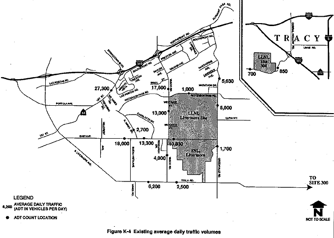
K.2.1.5 Average Daily Traffic Volumes
Existing average daily traffic volumes and machine count locations for the 18 key roadway segments are shown on Figure K-4 (TJKM Transportation Consultants, 1992). Machine counts are traffic counts conducted by using an automatic counting machine that tallies vehicles as they pass over a pressurized hose laid across a vehicle path. As described previously, all average daily traffic volumes presented in this appendix are two-way counts at the indicated locations. A description of the geometrics of the roadway segments evaluated is provided below.
First Street
First Street is a two-lane arterial street that widens to three lanes (one southbound and two northbound) between Southfront Road and the eastbound I-580 on-ramp. First Street is a State Highway, designated as Route 84. The interchange of First Street with I-580 is a partial clover-leaf with looped off-ramps in the northwest and southeast quadrants. The intersection of First Street at North Mines Road is currently signalized. The average daily traffic on First Street north of North Mines Road is approximately 27,300 vehicles per day. The design capacity of First Street north of North Mines Road is approximately 20,000 vehicles per day. Between I-580 and Southfront Road, the capacity is 22,500 vehicles per day. The existing volumes on First Street exceed capacity by approximately 5000 to 7000 vehicles per day.
Vasco Road
Vasco Road is a major arterial street south of I-580. It functions as the primary access route to LLNL Livermore site and SNL, Livermore from I-580. The interchange of Vasco Road at I-580 is a partial clover-leaf design with looped off-ramps in the northwest and southeast quadrants and a looped on-ramp in the northeast quadrant.
Between I-580 and Patterson Pass Road, Vasco Road has two lanes in both the northbound and southbound directions, separated by a raised median. There are striped bike lanes designated in each direction. Both sides of the road are posted for no parking. Separate left-turn lanes are provided at all intersections. The average daily traffic on Vasco Road north of Patterson Pass Road is approximately 17,600 vehicles per day. North of Patterson Road, capacity on Vasco Road is approximately 30,000 vehicles per day. Existing average daily traffic is within the capacity of the roadway. Improvements to widen Vasco Road between Patterson Pass Road and East Avenue were recently completed. The east side (adjacent to LLNL Livermore site) of Vasco Road was improved to its ultimate width, consisting of two northbound lanes and a raised median. Between Patterson Pass Road and Mesquite Way, there are two southbound through lanes. South of Mesquite Way, there is a single southbound through lane. This single southbound lane is an interim configuration until west-side development takes place and facilitates final widening improvements. Designated bike lanes are provided in both directions. The average daily traffic is approximately 13,000 vehicles per day south of Westgate Drive. The intersection of Vasco Road at East Avenue is signalized. When four-lane improvements to Vasco Road are completed, capacity south of Westgate Drive will be approximately 30,000 vehicles per day. Existing average daily traffic is within capacity. South of the East Avenue intersection, Vasco Road becomes a two-lane rural road. The average daily traffic in this section is approximately 4000 vehicles per day. It is estimated that the capacity of this section is approximately 10,000 to 12,000 vehicles per day.
Greenville Road
Greenville Road also provides access to the LLNL Livermore site and SNL, Livermore from I-580. There is no direct interchange between Greenville Road and I-580. Freeway access is west of Greenville Road at on- and off-ramps on Northfront Road and Southfront Road. Both Northfront Road and Southfront Road connect with Greenville Road. The Southfront connection is currently being widened and relocated as a part of improvements for a new business park in this area. North of Vaughn Avenue, Greenville Road has two lanes in both the northbound and southbound directions, separated by a raised median. Between Vaughn Avenue and Marathon Drive, Greenville Road narrows to two lanes with no median. There is an irregular gravel shoulder, and there are no bike lanes. Both sides of the road are posted for no parking. The road becomes very narrow at the Union Pacific Railroad underpass. Average daily traffic on Greenville Road north of Marathon Drive is currently 5630 vehicles per day. Capacity of Greenville Road is 17,500 vehicles per day. The existing average daily traffic is within capacity.
In the vicinity of Marathon Drive, Greenville Road widens as it approaches the stop-sign controlled intersection at Patterson Pass Road. This allows the provision of separate turn lanes at Marathon Drive and Patterson Pass Road. The west side of Greenville Road is improved in this area with a concrete curb and gutter.
South of Patterson Pass Road, Greenville Road returns to a two-lane configuration, and average daily traffic is approximately 5000 vehicles per day. There is a gravel shoulder in most areas, except on the west side in the vicinity of the east gate (Eastgate Drive) at LLNL Livermore site (where curbs are constructed). Both sides of the road are posted for no parking. Bike lanes are indicated by stripes in most areas but are not designated with signs. Currently, there is no traffic signal at the intersection of Greenville Road with Eastgate Drive, and traffic volumes do not warrant a signal at this time. At such time as traffic signal warrants are met, a signal may be necessary at this intersection. South of East Avenue, the average daily traffic is approximately 1700 vehicles per day. Greenville Road becomes a narrow rural road south of Tesla Road. Capacity of Greenville Road is 17,500 vehicles per day. The existing average daily traffic is within capacity.
East Avenue
East Avenue is a cross-town arterial that carries traffic between South Livermore Avenue and Greenville Road. East Avenue west of Vasco Road has two lanes in both the westbound and eastbound directions. There is no median, but separate left-turn lanes are provided at all intersections. There are designated bike lanes in both directions. Several major streets along East Avenue are controlled by traffic signals. Stop signs control East Avenue at its intersection with Dolores Street, causing some delay for East Avenue motorists. Average daily traffic on East Avenue west of Vasco Road is approximately 18,000 vehicles per day west of North Mines Road and 13,300 vehicles per day east of North Mines Road. Capacity of East Avenue west of Vasco Road is approximately 25,000 vehicles per day. The existing volumes are within capacity.
East Avenue east of Vasco Road provides access to the south gates of the LLNL Livermore site and provides the sole access to all gates at SNL, Livermore. Traveling east from Vasco Road, East Avenue has two lanes in both the eastbound and westbound directions. Bike lanes are provided on the north and south sides of East Avenue and are separated from traffic by asphalt curbs. There are several pedestrian crossings linking the LLNL Livermore site and SNL, Livermore, including one just west of the LLNL Livermore site south gate entrance, where East Avenue narrows to a two-lane road. Here, striped bike lanes are provided, but asphalt curb separations are not provided. East Avenue between Vasco Road and Greenville Road is posted on both sides for no parking. Average daily traffic in the area west of the Laboratory entrances in the four-lane section is approximately 10,830 vehicles per day. This street forms a T-intersection with Greenville Road. Capacity on the four-lane portion of East Avenue east of Vasco Road (between Vasco Road and the LLNL Livermore site south gate entrance) is approximately 25,000 vehicles per day. The two-lane portion of East Avenue east of Vasco Road has a capacity of approximately 15,000 vehicles per day. The existing volumes are within capacity.
North Mines Road
North Mines Road runs generally in a north-south direction between First Street and East Avenue. It is a four-lane road and is signalized at its intersection with First Street. Currently, North Mines Road is discontinuous at the railroad tracks north of Patterson Pass Road. North Mines Road was selected as a key roadway in this study because it is planned to be a through street between First Street and East Avenue. It might then become an access route to the LLNL Livermore site and SNL, Livermore via Patterson Pass Road and East Avenue. Currently, the northern section of North Mines Road serves industrial traffic, while the southern section serves residential traffic. The intersection of North Mines Road with East Avenue is signalized. North of East Avenue, the existing average daily traffic is approximately 2700 vehicles per day. The capacity of North Mines Road is approximately 25,000 vehicles per day. The existing volumes are within capacity.
Patterson Pass Road
Patterson Pass Road runs generally in an east-west direction just north of the LLNL Livermore site and terminates at North Mines Road. Patterson Pass Road east of Greenville Road is a two-lane rural road. Between Greenville Road and North Mines Road, Patterson Pass Road is improved with two lanes in each direction, a raised median, bus turnouts, and separate left-turn lanes. Both sides of the street are signed for no parking, and striped bike lanes are provided in both directions. There is no direct gate access to LLNL Livermore site from Patterson Pass Road. The existing average daily traffic between Vasco Road and Greenville Road is approximately 1000 vehicles per day. Capacity of Patterson Pass Road between Vasco Road and Greenville Road is approximately 30,000 vehicles per day. The existing average daily traffic is within capacity.
Tesla Road/Corral Hollow Road
Tesla Road is a two-lane rural road south of SNL, Livermore. This road does not provide direct gate access to either the LLNL Livermore site or SNL, Livermore. Tesla Road runs in a generally east-west direction between the City of Livermore and I-580 in San Joaquin County. Tesla Road east of Greenville Road is a winding road with several hairpin turns. The road's name changes to Corral Hollow Road at the Alameda County/San Joaquin County line. Tesla Road/Corral Hollow Road is the only access to LLNL Site 300.
Average daily traffic on Tesla Road west of Vasco Road is approximately 6200 vehicles per day. Tesla Road east of Vasco Road currently experiences average daily traffic of approximately 2500 vehicles per day. In the vicinity of LLNL Site 300, average daily traffic on Corral Hollow Road is approximately 700 vehicles per day west of LLNL Site 300 and 850 vehicles per day east of LLNL Site 300. Capacity on Tesla/Corral Hollow Road is approximately 10,000 vehicles per day. The existing volumes are within capacity.
K.2.1.6 Study Area Traffic Accident History
A review of Statewide Integrated Traffic Records System accident reports was made for 1988, 1989, and 1990 to determine the accident history at the LLNL Livermore site and SNL, Livermore study intersections and in the vicinity of LLNL Site 300. A tally of accidents by year was made, and a 3-year accident rate was calculated for study intersections.
The results of the analysis indicated that three Vasco Road intersections (at Preston Avenue, Brisa Street, and Vaughn Avenue) and First Street intersections between North Mines Road and Southfront Road have experienced relatively high accident rates and have already been targeted by the City of Livermore for safety improvements. Traffic studies and planned improvements (in conjunction with other projects in the area) are underway to mitigate traffic conditions in these areas; therefore, no further analysis has been conducted for this EIS/EIR for the identified accident areas. The recent improvements along Vasco Road and those planned for First Street have been described in section K.2.1.4. In addition, the intersection of Vasco Road at Preston Avenue was modified during 1990 to prohibit left turns from Preston Avenue onto Vasco Road. According to the City of Livermore, this mitigation has virtually eliminated accidents at this location. There is a new traffic signal at the intersection of Vasco Road at Brisa Street, and an additional signal is planned for the intersection of Vasco Road at Vaughn Avenue. Vasco Road is currently being widened between Brisa Street and Vaughn Avenue with two through lanes in the north- and southbound directions and separate right-turn lanes.
Accidents in the vicinity of LLNL Site 300 occur between I-580 and the Alameda/San Joaquin County Line at a rate of approximately four accidents per year. There is no recurring location for these accidents, which consist primarily of property damage caused by single-driver run-offs. No further review was warranted.
K.2.1.7 Onsite Circulation
LLNL Livermore Site
External Access
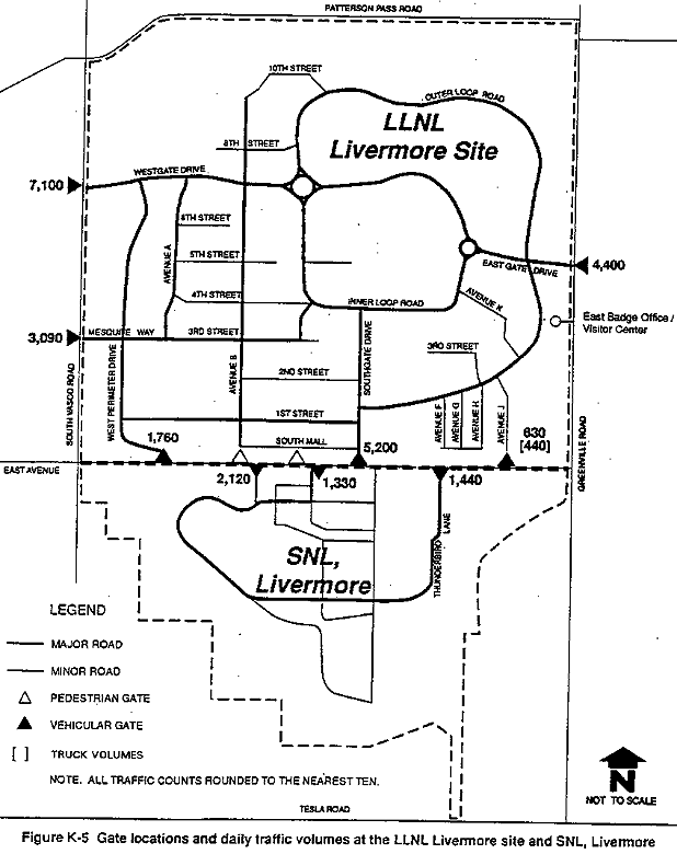
Vehicle access to the LLNL Livermore site is currently provided at six locations. Westgate Drive and Mesquite Way entrances are on the western periphery of the site and provide access from Vasco Road. To the south, adjacent to East Avenue, are the Southgate Drive and Southwest Gate entrances. From Greenville Road, the Eastgate Drive entrance provides access to the east side of the LLNL Livermore site. An additional entrance to the LLNL Livermore site from Greenville Road is located south of the Eastgate Drive gate entrance. This entrance, which accesses the East Badge Office, Visitor's Center, and Credit Union, is not a formal gate entrance and no vehicular traffic can access the remainder of the LLNL Livermore site from this location. A shipping and receiving gate is on the north side of East Avenue between Greenville Road and the Southgate entrance. The existing (1991) inbound and outbound traffic volumes at these gates are shown in Figure K-5. As shown on Figure K-5, the LLNL Livermore site pedestrian gates are on East Avenue between the Southwest Gate and Southgate Drive. Although no pedestrian counts were made at these locations, these gates provide access between the two Laboratories as well as access for LLNL Livermore site personnel who park at SNL, Livermore.
Onsite Street Network
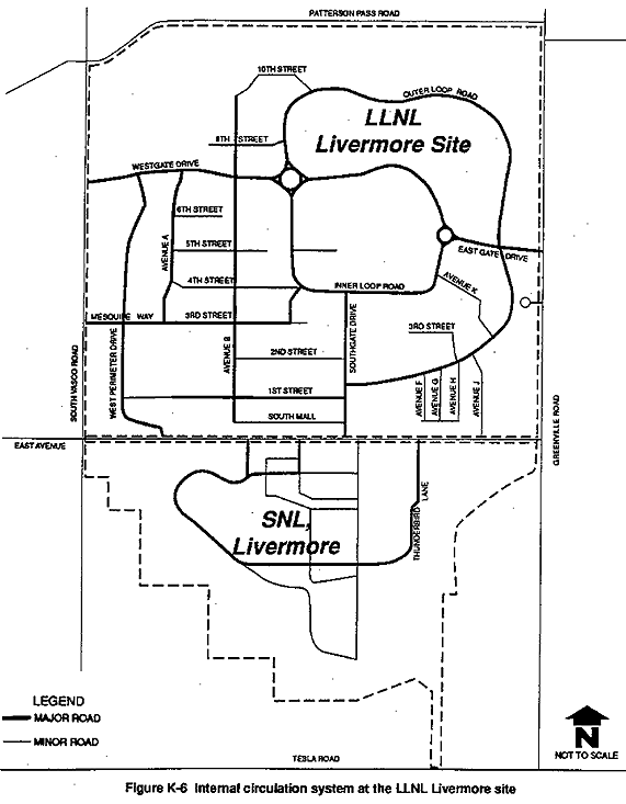
The existing internal circulation network is depicted in Figure K-6. Primary internal circulation roads are Inner Loop Road, Outer Loop Road, Eastgate Drive, Southgate Drive, Westgate Drive, Avenue A, and Mesquite Way. Newer sections of the LLNL Livermore site are served by streets that extend outward from the two main loop roads. There is no major circulation road through the southwest quadrant. Streets in this older section of the facility form a grid pattern. This quadrant is the most densely populated of the entire site, and is a limited access area. This security rating affects the feasibility of including the southwest quadrant in the overall circulation network because there is not the same free flow of traffic movement through this quadrant.
Although not all internal streets are depicted on Figure K-6, the LLNL Livermore site street network is currently designated by a usage hierarchy of major, minor, service, and fire categories (LLNL, 1989b). Major roads serve as arterials between quadrants. Minor roads function as collectors and link major roads to specific facilities. Service roads are typically short and are limited to serving only a few destinations. Fire roads are designated for emergency service.
A traffic circulation and access study was conducted for LLNL that identified and recommended mitigations for onsite access and circulation problems (TJKM Transportation Consultants, 1986). The study evaluated 1986 and future year 2000 traffic conditions. The Planning and Development Department at the LLNL Livermore site continues to utilize the 1986 study as a guide for onsite traffic improvements.
The key recommendations of that study were to provide additional inbound access lanes at the Eastgate portal, to increase capacity at the intersection of Mesquite Way and Vasco Road, and to develop two new gate facilities at Westgate Drive and Patterson Pass Road. In response to those recommendations, a new Westgate Drive portal has been constructed. A third westbound (inbound) lane has been added to the Eastgate portal, and a traffic signal and street improvements are under construction at the Mesquite Way intersection at Vasco Road. The installation of a Patterson Pass Road gate is part of the long range planning at LLNL Livermore site, but is not being considered as part of the EIS/EIR proposed action.
In recent discussions with LLNL Livermore Facilities Planning staff, two existing onsite circulation problems were identified (TJKM Transportation Consultants, 1992): (1) a.m. peak-hour queuing and delays at the intersections of Westgate Drive and Avenues A and B; and (2) p.m. peak-hour queuing in the eastbound exiting lanes at Eastgate Drive.
Peak-hour turning movement counts were taken at all three intersections. Based on these counts and on field observation, traffic currently has no difficulty moving through the Westgate Drive intersections during the a.m. peak period and queuing is minimal (TJKM Transportation Consultants, 1992). No mitigation is warranted at this time, although growth in the northwest quadrant may create poorer conditions in the future. Based on a recent p.m. peak-hour turning movement count, the intersection of Greenville Road at Eastgate Drive/Lupin Way is approaching design capacity. This results in long delays for the eastbound-to-northbound left-turn movement out of the LLNL Livermore site. The reserve capacity for this movement is 24 vehicles. Reserve capacity is the unused capacity of a vehicle travel lane (i.e., the number of additional vehicles that could make a particular turning movement before that movement reaches capacity). Although the intersection does not yet meet peak-hour traffic signal warrants, future traffic conditions may create a need for traffic signals at this location.
Onsite Parking
It has been the practice at LLNL to provide personnel parking close to the work places. The latest parking demand evaluation was conducted by LLNL in 1988 in their Parking Master Plan (LLNL, 1988). At that time the reported LLNL Livermore site population was 10,458, including regular and contract personnel. The net demand for personnel parking was determined to be 0.71 stall per person. The required personnel parking need was calculated to be 7425 parking stalls.
When calculating the parking supply, the LLNL Livermore site takes into consideration the number of marked parking spaces both in parking lots and on streets. The 1988 LLNL analysis also considered the availability of safely parked vehicles in unmarked areas. As described in the Parking Master Plan, these are vehicles not in marked parking lots or roadside stalls, but that are parked safely and orderly on paving, neither causing a security problem, nor blocking moving traffic. In 1988, there were approximately 5576 marked personnel parking stalls and 539 available unmarked parking stalls.
Using number of personnel by site location, the deficit of personnel parking was determined in the Parking Master Plan to be 1310 stalls. In calculating 1991 parking demand, 1988-approved or 1988-funded improvements for 913 parking stalls are considered to exist, resulting in a net deficit of 397 parking stalls before taking personnel increases into consideration.
The 1991 number of LLNL Livermore personnel is reported to be approximately 11,200 persons. This equates to an increase of 742 persons and an increase in parking demand of 527 stalls (742×0.71). When added to the 1988 deficit of 396 stalls, the revised parking stall deficit is 923 onsite personnel parking stalls.
There are also 962 assigned government vehicles located onsite, including those assigned to the Protective Force Division. As of 1988, there were a total of 844 government vehicle parking stalls located both within and outside of parking lots onsite, with a resulting deficit of 118 government vehicle stalls. Planned improvements included 11 government vehicle stalls, which would reduce the deficit by nine percent to 107 government vehicle stalls (LLNL, 1988).
Onsite Accident History
The traffic study (TJKM Transportation Consultants, 1992) did not review any accidents or Statewide Integrated Traffic Records System reports for onsite traffic accidents, but, according to the LLNL Planning and Development Department and the Protective Force Division, the majority of onsite accidents take place in the LLNL Livermore site parking lots. Parking lot accidents are not typically mitigated by physical street improvements. It should be noted that the security division has stated that there have been approximately seven serious onsite traffic accidents during the 3-year evaluation period; however, the number of onsite accidents was not considered substantial enough to allow further analysis for accident trends (i.e., there are not enough accidents at any one location to facilitate a trend analysis).
SNL, Livermore
SNL, Livermore personnel are restricted from driving through the SNL, Livermore facility grounds and are required to park in lots adjacent to East Avenue or near the Combustion Research Facility on Thunderbird Lane. Existing 1991 parking lot driveway counts for SNL, Livermore are shown on Figure K-5. It should be noted that LLNL Livermore site personnel may park in the SNL, Livermore parking areas if they have been issued a parking identification sticker for those lots. Although LLNL utilizes Parking Lot B99 on the south side of East Avenue, this lot is interconnected with the other SNL, Livermore parking lots. Personnel from both facilities may park in either lot. There are a total of 2000 parking stalls in these lots. Additional parking stalls for government vehicles are provided within the SNL, Livermore grounds. No parking stall deficiencies are currently identified at SNL, Livermore.
As a result of the onsite driving restrictions at SNL, Livermore, there was no evaluation of onsite circulation or traffic accident history.
LLNL Site 300
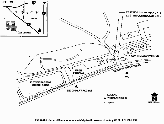
Site access to LLNL Site 300 is primarily provided from a series of two security gates at the main entrance on the north side of Corral Hollow Road, approximately 8 miles west of the City of Tracy. An additional access, into a parking area only, is located to the west of the main entrance off Corral Hollow Road. A daily volume count at the main access is shown on Figure K-7. Vehicular access around LLNL Site 300 is, for the most part, limited to parking lots and roadways in the southeast corner of the site near the General Services Area. There are 185 parking stalls designated at LLNL Site 300, including those used by government vehicles. On an average day, there are 50 to 60 empty stalls; therefore, adequate parking is available. Access to roadways in the northern limited area is restricted.
Access problems have been identified at the LLNL Site 300 main gate area. The existing design is operationally poor, and vehicle queuing areas are inadequate. In conjunction with the LLNL Site 300 facilities revitalization efforts, a study is in final design that includes a new main gate with associated roads, guard kiosk, and other amenities. The main site entrance will be relocated slightly to the west of its present location. The project will involve a complete appraisal of the needs of LLNL Site 300 users and the site infrastructure. New roads in the limited area will be considered to replace some existing roads with steep grades.
K.2.2 Traffic Analysis and Modeling Methodologies
This section provides a more detailed description of the intersection capacity utilization method that was used to evaluate traffic congestion at study intersections. The volume-to-capacity ratios and level of service ratings that quantify the amount of congestion at a given intersection are described. This section also describes the transportation modeling process used to project and evaluate future traffic conditions in the vicinity of the project sites.
K.2.2.1 Description of Intersection Capacity Analysis and Level of Service Ratings
The traffic study (TJKM Transportation Consultants, 1992) uses a method of intersection capacity analysis known as the Intersection Capacity Utilization method. A variation (and derivation) of the TJKM method, known as the critical movement analysis, is described in the 1985 Highway Capacity Manual, Special Report 209, published by the Transportation Research Board of the National Academy of Sciences.
The Intersection Capacity Utilization method sums the V/C ratios of all governing (or critical) signal phases at an intersection to produce an overall intersection V/C ratio. When the ratio of V/C reaches unity (1.00), the intersection is "at capacity" and is described as operating at LOS E and approaching LOS F conditions. Table K-2 provides a description of the relationship between the level of service rating and the V/C ratio.
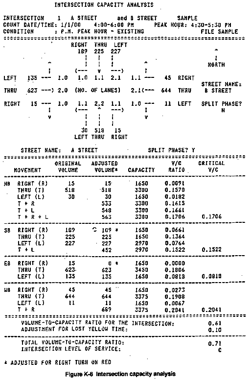
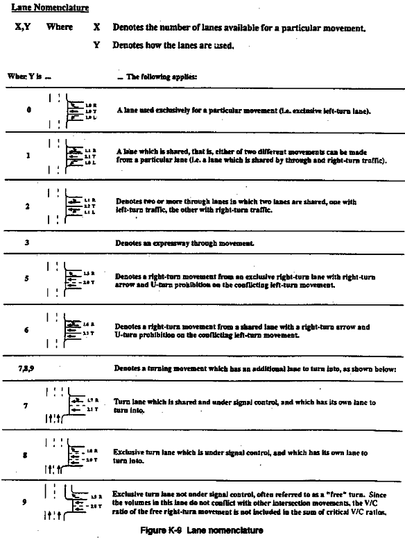
A sample calculation is shown on the accompanying computer printout (Figure K-8). This example describes a hypothetical intersection at A Street and B Street, which is regulated by three-phase traffic signals, indicating separate signal phases for northbound, southbound, and east-west traffic. The first phase (illustrated in Figure K-8 at top of sample and defined in second, southbound set of directional figures) is for southbound traffic only and contains three lanes. Right-turn movements in the right lane (189 vehicles) have a smaller per-lane volume than in the two remaining lanes (225 and 227 vehicles). Therefore, the length of the signal phase is governed by the traffic in the two left lanes (through plus left). The capacity of Phase 1 is 2970 vehicles per hour of green, the volume is 452 vehicles, and the resulting V/C ratio is 0.1522. Phase 2, for the northbound movements, has two sets of combined governing lanes and a final V/C ratio of 0.1706. For Phase 3, the westbound through-plus-right traffic cannot proceed through the intersection at the same time as the eastbound left-turn movement, even though they are on the same signal phase. Practically, the left-turn vehicles and opposing through traffic alternate as gaps in traffic allow. The total Phase 3 capacity requirement is the sum of the combined westbound through and right, 0.2041, and the eastbound left, 0.0818. The critical movement V/C ratios are summed, then rounded to two decimal places. An allowance for yellow time (see Table K-3), assumed to be lost time for vehicle movement, is added to obtain the overall intersection V/C rating. In the example, the intersection total V/C ratio of 0.71 equates to a LOS C designation. The number of lanes and the use of the lanes is denoted with special nomenclature, as described in Figure K-9.
The advantage of this method of capacity calculation is its direct relationship to actual intersection operations and the ease with which changes in volume and capacity can be analyzed. In addition, the level of accuracy of this method is comparable to that of the traffic projection process used to determine future traffic volumes.
Table K-2 Summary of Levels of Service for Intersections
| Level of Service | Type of Flow | Delay | Maneuverability | V/C Ratio |
| A | Stable Flow | Very slight or no delay. If signalized, conditions are such that no approach phase is fully utilized by traffic and no vehicle waits longer than one red indication. | Turning movements are easily made, and nearly all drivers find freedom of operation. | 0.00–0.60 |
| B | Stable Flow | Slight delay. If signalized, an occasional approach phase is fully utilized. | Vehicle platoons are formed. Many drivers begin to feel somewhat restricted within groups of vehicles. | 0.61–0.70 |
| C | Stable Flow | Acceptable delay. If signalized, a few drivers arriving at the end of a queue may occasionally have to wait through one signal cycle. | Back-ups may develop behind turning vehicles. Most drivers feel somewhat restricted. | 0.71–0.80 |
| D | Approaching Unstable Flow | Tolerable delay. Delays may be substantial during short periods, but excessive back-ups do not occur. | Maneuverability is severely limited during short periods due to temporary back-ups. | 0.81–0.90 |
| E | Unstable Flow | Intolerable delay. Delay may be considerable (up to several signal cycles). | There are typically long queues of vehicles waiting upstream of the intersection. | 0.91–1.00 |
| F | Forced | Excessive delay. | Jammed conditions. Back-ups from other locations restrict or prevent movement. Volumes may vary widely, depending principally on the downstream back-up conditions. | Varies* |
* In general, volume-to-capacity ratios cannot be greater than 1.00, unless the lane capacity assumptions are too low. Also, if future demand projects are considered for analytical purposes, a ratio greater than 1.00 might be obtained, indicating that the projected demand would exceed the capacity.
Source: Transportation Research Board, 1985; Highway Research Board, 1965; TJKM Transportation Consultants, 1992.
Table K-3 TJKM Yellow Time Adjustment for Calculating V/C Ratios for V/C Calculations
| Green Time | Add Yellow (Lost) Time | Total |
| 0.71 | 0.10 | 0.81 |
| 0.72 | 0.10 | 0.82 |
| 0.73 | 0.10 | 0.83 |
| 0.74 | 0.10 | 0.84 |
| 0.75 | 0.09 | 0.84 |
| 0.76 | 0.09 | 0.85 |
| 0.77 | 0.08 | 0.85 |
| 0.78 | 0.08 | 0.86 |
| 0.79 | 0.07 | 0.86 |
| 0.80 | 0.07 | 0.87 |
| 0.81 | 0.06 | 0.87 |
| 0.82 | 0.06 | 0.88 |
| 0.83 | 0.05 | 0.88 |
| 0.84 | 0.05 | 0.89 |
| 0.85 | 0.04 | 0.89 |
| 0.86 | 0.04 | 0.90 |
| 0.87 | 0.03 | 0.90 |
| 0.88 | 0.03 | 0.91 |
| 0.89 | 0.02 | 0.91 |
| 0.90 | 0.02 | 0.92 |
| 0.91 | 0.01 | 0.92 |
| 0.92 | 0.01 | 0.93 |
| 0.93 | 0.00 | 0.93 |
| Lane Capacitiesa | ||
| Designation | Through Capacity | Turn Capacity |
| 1.0 | 1725 | 1650 |
| 1.1 | 1650 | 1650 |
| 2.0 | 3450 | 2970 |
| 2.1 | 3375 | 2970 |
| 2.2 | 3300 | --- |
| 3.0 | 5175 | 4290b |
| 3.1 | 5100 | 4290 |
| 3.3 | 5550 | --- |
| 4.0 | 6900 | --- |
| 4.1 | 6825 | --- |
| V/C | LOS | V/C | LOS |
| 0.00–0.60 | A | 0.81–0.90 | D |
| 0.61–0.70 | B | 0.91–1.00 | E |
| 0.71–0.80 | C | 1.00+ | F |
a The assumed capacities of the most common types
of lanes.
b 80 percent each of second and third lanes.
Source: TJKM Transportation Consultants, 1992.
K.2.2.2 Traffic Modeling Process
Traffic forecasting models are frequently used in transportation planning. A model is a mathematical way of describing the structure, performance, and behavior of the physical transportation system. It allows transportation engineers and planners to simulate and evaluate the interactions among various components of the transportation system, both present and future, by replicating as nearly as possible what exists in the real world and forecasting different levels of transportation and land use growth. Transportation demand estimation quantifies the amount of travel on the transportation system.
By using a model to represent the existing transportation system, future demand for travel can be analyzed given a specific set of projected land use developments and transportation plans. The demand for transportation is created by resident activity and commercial and employment centers; and the supply, which limits the amount of movement to and from activity centers, is represented by the service characteristics of the highway and transit systems.
Modeling involves many detailed tasks that evolve into a description of travel patterns in and around a study area. Before forecasting travel, an inventory of data is performed to establish relationships among travel choices and other variables in the existing transportation system. The first step in the modeling process involves choosing a model type and specifying variables. Second, the model is calibrated to reproduce the current observed travel behavior as accurately as possible. Finally, the projected travel demand is forecasted. The types of input data needed for modeling include current data and future projections of such variables as number of dwelling units and land use floor-area totals. Also included are current data and future projections of transportation system performance variables such as average vehicle speeds, roadway length, roadway capacity, and travel time. Information is collected about the current level of activity and the current transportation network to predict travel patterns on the future transportation network.
The travel demand model used in the traffic study (TJKM Transportation Consultants, 1992) is MINUTP. It has been used throughout the United States, including cities and counties in northern California. The model is run on a micro-computer. (It should be noted that the evaluation of LLNL Site 300 traffic impacts did not utilize a traffic model).
Transportation Network Assumptions
A transportation system consists of networks that represent available modes of travel. The networks are defined by numbering key intersections, called nodes, and identifying the segments between them, called links. The result is a geometric interpretation of the transportation system identifying travel routes in the study area. The Livermore traffic model utilized in the traffic analysis for LLNL Livermore site and SNL, Livermore is a vehicle model only (TJKM Transportation Consultants, 1992). Mass transit networks were not included in the modeling effort. During the modeling process, the trip generation produces individual person trips and, for the purposes of trip assignment, vehicle trips are used. The person trips must first be split into the public transit and the auto person trips. Then the auto person trips are converted to auto vehicle trips by the application of the auto occupancy factors (Metropolitan Transportation Commission, 1981).
Traffic Zones
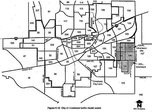
The study area is separated into smaller areas called traffic zones. The zones vary in size depending on the intensity of activity, the nature of the land use within the zones, and the level of detail required in the analysis. Generally, the zonal borders are defined by homogeneous urban activities and follow natural boundaries (e.g., ridges, creeks), or man-made boundaries (e.g., streets, railroad tracks). More than 258 traffic zones were developed for the Livermore traffic model. Specifically, there are 69 traffic zones that represent the City of Livermore. A map showing the location of each City of Livermore traffic zone is presented in Figure K-10.
Nodes and Links
The transportation system is described in terms of nodes (intersections) and links (street segments). The type of data used to describe each link are node identification, average vehicle speed, link capacity, travel direction, link length, directional volume counts, number of lanes, and other information depending on the intended use. Not every street segment or intersection is represented in the model. Traffic zone centroids represent the centers of activity, rather than the geometric centers of the zones. A centroid, as used in the modeling process, is an assumed point within a traffic zone from which traffic generated by the land uses in that zone can be connected to the roadway system. Centroids are connected to nodes by imaginary links called centroid connectors. These connectors may represent entry streets into subdivisions and major driveways into office, industrial, and commercial sites. In the network, zone centroids are points where vehicle trips either begin or end. The model loads the vehicle trips onto the network from these zone centroids via the centroid connectors.
The Livermore traffic model consists of a series of nodes and links. Links are coded by facility type. This coding process permits flexibility in the presentation of results. The I-580 freeway and interchange ramps are also represented on the network by links and nodes. Following the network coding process, the network can be plotted with the aid of a computer. The ability to plot with computers ensures more accurate and reliable base networks.
Modeling Steps
Link data and land use data are used as inputs in the modeling process. The steps in the modeling process include network building, trip generation, path building, trip distribution, trip matrix adjustments, mode choice, trip matrix balancing, and trip assignment. These terms are defined in the Glossary. An iterative loop between the end of the trip-assignment phase and the beginning of the path-building phase is included in the modeling process to provide more stable and accurate trip tables.
The sequence of the steps used to model trip-making behavior depends on the type of area being studied and what sequence of steps is most applicable to the analysis and modeling procedures being used. The order of the steps should reconstruct the trip-making behavior of the traveler. The following sequence is used in this study: the trip maker decides to make a trip (generation), then where to go (trip distribution), then how to go (mode choice), and finally, which route to take (trip assignment).
K.2.2.3 Traffic Model Assumptions
LLNL Livermore Site and SNL, Livermore
The description of existing traffic conditions presented earlier in this appendix is based on actual traffic counts conducted by TJKM Transportation Consultants (1992). Evaluation of the existing plus proposed action scenario involves the distribution of the new vehicle trips anticipated in conjunction with the proposed action onto the existing roadway network in the same proportion as the existing Laboratories-related traffic.
Future (i.e., cumulative) traffic conditions (which assume an approximate year 2010 buildout of the General Plan land uses within the study area and, therefore, are also considered to represent cumulative conditions) were analyzed using the MINUTP travel forecasting model of the Tri-Valley area developed by TJKM Transportation Consultants (1992) and described in more detail in section K.2.2.2. This Tri-Valley traffic model consists of a detailed transportation network and traffic zone system for the entire Tri-Valley area (defined as the incorporated cities of Livermore, Pleasanton, Danville, San Ramon, and Dublin as well as adjacent portions of unincorporated Alameda and Contra Costa Counties). The model also incorporates assumptions for the balance of the nine-county Bay Area Region and key external stations such as San Joaquin County.
The land use data for Tri-Valley cities are based on the general plans of the individual jurisdictions while the data for the rest of the nine Bay Area counties are based on the Association of Bay Area Governments Projections '90 (Association of Bay Area Governments, 1989). The Association of Bay Area Governments, in its role as the metropolitan council of governments, prepares projections of Bay Area employment and household growth and allocates this growth to various jurisdictions within the Bay Area.
Cumulative analyses for the proposed action and the no action alternative included the distribution of Laboratory traffic and general plan buildout traffic onto the existing roadway network. (The existing roadway network includes any approved but not yet constructed roadway improvements that would be completed in FY 1992). In addition, model runs were conducted for the no action and proposed action scenarios assuming various roadway improvements in the model area that are not yet, but which are expected to be, approved and funded. The purpose of these analyses was to demonstrate how traffic conditions would be improved with implementation of these improvements. The following anticipated improvements that affect the operations of study intersections were assumed for the no action and proposed action "cumulative (planned roadway network)" scenarios:
- Extension of Concannon Boulevard from Isabel Avenue to Telsa Road.
- Extension of Las Positas Road from First Street to Vasco Road.
- Extension of Brisa Street from Vasco Road to Greenville Road.
- Extension of North Mines Road from East Avenue to First Street.
- A standard partial cloverleaf interchange configuration was assumed for interchanges along I-580 at North Livermore Avenue, First Street, Vasco Road, and Greenville Road in the City of Livermore.
- Widening of First Street from the existing two lanes to six lanes from north of North Mines Road to the I-580 eastbound on-/off-ramps.
It should be noted that evaluation of the modification of operations alternative utilized the proposed action traffic analysis as a base, due to the fact that personnel increases and, thus, traffic generation, are assumed to be the same for both scenarios. Evaluation of the shutdown and decommissioning alternative did not utilize a traffic model.
LLNL Site 300
The traffic projections on Corral Hollow Road near LLNL Site 300 are based on information provided by the County of San Joaquin. The county is in the process of updating the County General Plan; therefore, the projected traffic volumes are preliminary. Intersection capacity utilization analysis was conducted for existing conditions at the intersections at the I-580/Corral Hollow Road interchange, and future traffic volumes along Corral Hollow Road were projected.
K.2.3 Alternate Modes of Transportation
Transit service is available directly to the LLNL Livermore site and SNL, Livermore by the local Wheels bus service and by BART (Bay Area Rapid Transit) Express. BART Express is a bus service with direct freeway routes between the Tri-Valley and BART train stations in the cities of San Leandro and Hayward. There are four BART Express routes serving the Tri-Valley.
Wheels Route 10 is a local, cross-valley bus route that provides service from Stoneridge Mall in Pleasanton to the LLNL Livermore site and SNL, Livermore. There are two BART Express transfer stations along this route. Wheels Route 12 provides local service between Las Positas College and the Triad business park in northwest Livermore, through downtown Livermore, to the LLNL Livermore site. There are also two BART Express transfer stations along Route 12.
It is estimated that the existing direct transit service to the LLNL Livermore site and SNL, Livermore by the local Wheels bus service and by Bay Area Rapid Transit (BART) Express would not be unduly impacted by the projected personnel increase under the proposed action.
K.2.3.1 LLNL Livermore Site
LLNL Livermore site conducts a ridesharing program as part of its in-house energy management program. The program began in 1976. One goal of the ridesharing program is to reduce onsite traffic and parking problems at the LLNL Livermore site. There is a designated onsite rideshare coordinator who maintains a database of individuals participating in the program. There are currently more than 474 carpools (estimated 700 riders) and 43 vanpools (estimated 565 riders) participating in the rideshare program (LLNL, 1991a).
The Stockton Metropolitan Transit District also supplies four buses, driven by LLNL drivers, which provide ridesharing opportunities to LLNL Livermore site and SNL, Livermore personnel from outlying cities (three from Manteca, two from Stockton, and one from Tracy).
Onsite transportation alternatives are also provided within the LLNL Livermore site. There are taxis (i.e., on-call shuttle vans) and energy-efficient carts available for onsite trips. As of 1991, the taxi fleet consisted of nine taxis (12 to 15 passengers), three buses (27 to 37 passengers), two station wagons, and a van. More than 700 laboratory bicycles are present throughout the facility for onsite travel. It is estimated that collectively these bicycles are ridden more than 500 miles per day (LLNL, 1991a).
LLNL is currently developing an expanded Transportation Systems Management Program to promote more efficient use of the transportation network and help reduce traffic congestion. This program would be an extension of the current ridesharing and transit opportunities available to Laboratory employees. In addition to reducing traffic congestion, this program would aid LLNL in complying with federal and state mandates related to vehicle emissions reductions. The program would include such elements as carpools, vanpools, transit, bicycles, telecommuting, emergency ride home, guaranteed ride home, and flexible work schedules.
K.2.3.2 LLNL Site 300
There are currently 26 carpools and two vanpools operating at LLNL Site 300. Parking stalls are reserved for these vehicles onsite. There are an estimated 49 carpool riders and 14 vanpool riders participating at the present time. There are also 155 government vehicles assigned to LLNL Site 300. Currently, there is no bus service to the site.
K.2.3.3 SNL, Livermore
There is no formal rideshare program at SNL, Livermore. There are two vanpools (estimated 19 riders) and 20 carpools (estimated 60 riders) known to be active at the site. SNL, Livermore personnel can also participate in the ridesharing opportunities provided by the Stockton Metropolitan Transit District buses discussed in section K.2.3.1. Informal rideshare matching is facilitated through a weekly newsletter.
Personnel at SNL, Livermore are restricted from driving on SNL, Livermore facility grounds; vehicle access is limited to parking areas adjacent to East Avenue. Onsite transportation is provided via approximately 200 bicycles and 131 gasoline- and electric- powered carts. Fifty government vehicles are assigned for use by specific SNL, Livermore departments onsite, including Protective Services.
As discussed previously, transit service is available at SNL, Livermore via Wheels and BART Express bus services. A bus stop turnaround is provided onsite.
K.3 TRANSPORTATION OF HAZARDOUS, RADIOACTIVE AND MIXED MATERIALS OR WASTES
This section discusses the procedures that LLNL and SNL, Livermore follow in receiving hazardous and radioactive materials, in safely moving these materials and wastes onsite, and in preparing them for offsite shipment. The discussion focuses particular attention on the organizational responsibility for implementing these procedures. Table K-4 lists the transportation-related definitions of hazardous, radioactive, mixed, and medical materials or wastes received and transferred onsite at LLNL and SNL, Livermore or prepared for shipment offsite.
In describing the transportation of hazardous, radioactive, mixed, and medical materials or wastes at LLNL and SNL, Livermore, the terms "transfer" and "transferring" refer to the intrasite movement of hazardous materials, while the terms "shipment" or "shipping" indicate the movement of materials or wastes offsite on public roads and highways (LLNL, 1991c). Under these definitions, the movement of materials or waste between the LLNL Livermore site and LLNL Site 300, or between the LLNL Livermore site and SNL, Livermore is considered a shipment.
Consistent with U.S. Department of Transportation (DOT) regulations, hazardous, radioactive, mixed, and medical materials and wastes are considered to be included within the hazardous materials and wastes classifications in the discussions in this appendix. For consistency with other parts of the EIS/EIR, material-specific details of the transportation requirements for the various materials will be highlighted separately. Medical wastes are only considered hazardous during onsite transfer because they must be sterilized before they are shipped offsite to a sanitary landfill. Medical wastes categorized as sharps waste (e.g., needles, blades, glass slides) are incinerated onsite.
Table K-4 Transportation-Related Definitions of Types of Hazardous, Radioactive, Mixed, and Medical Materials or Wastes
| Types of Materials or Wastes | Definition |
| Hazardous Materials | "A substance or material, including a hazardous substance, which has been determined by the Secretary of Transportation to be capable of posing an unreasonable risk to health, safety, and property when transported in commerce, and which has been so designated" (49 C.F.R. 171; DOE, 1986). |
| Hazardous Wastes | Wastes designated hazardous by Environmental Protection Agency (EPA) regulations (40 C.F.R. 261) and by the State of California (Title 22 of the California Code of Regulations). As used throughout this appendix, the term "hazardous waste" refers to nonradioactive, hazardous wastes. |
| Radioactive Materials | Any material having a specific activity greater than 0.002 microcuries per gram (49 C.F.R. 171.403; DOE, 1986). |
| Radioactive Wastes | "Solid, liquid, or gaseous material that contains radionuclides regulated under the Atomic Energy Act of 1954, as amended and of negligible economic value considering costs of recovery" (DOE Order 5820.2A). (See Appendix B for definitions of low level wastes and transuranic wastes.) |
| Mixed Wastes | Wastes that contain both radioactive and hazardous components as defined by the Atomic Energy Act and the RCRA (DOE Order 5820.2A; DOE Order 5400.3). |
| Medical Wastes | Wastes that consist of biohazardous waste and sharps (e.g., needles, blades, and glass slides) waste, managed in accordance with Chaptaer 6.1 of the California Health and Safety Code, are sterilized before shipment and, therefore, are not considered hazardous waste. |
K.3.1 Transportation Regulatory Environment
This section provides a brief summary of the regulatory requirements for transporting hazardous and radioactive materials and wastes outside the boundaries of LLNL and SNL, Livermore. Hazardous materials arriving at LLNL and SNL, Livermore and hazardous materials and wastes shipped from the sites must comply with these regulations. Although the transfer of hazardous, radioactive, mixed, and medical materials or wastes onsite is subject primarily to DOE requirements, as a minimum these requirements provide safety equivalent to the DOT regulations for offsite shipments (e.g., placarding and packaging requirements).
The section also identifies and discusses the responsibilities of the federal and state agencies responsible for administering and enforcing these regulations. Table K-5 lists major regulatory requirements and responsible agencies affecting the movement of hazardous materials and wastes.
Table K-5 Regulations or Guidance for the Transportation of Hazardous, Radioactive, and Mixed Materials or Wastes
| Regulations or Guidance | Responsible Agency |
| Title 10 Code of Federal Regulations section 71 (10 C.F.R.) | Nuclear Regulatory Commission |
| Title 49 Code of Federal Regulations sections 171–177 (49 C.F.R.) | U.S. Department of Transportation |
| Title 40 Code of Federal Regulations sections 260–263 (40 C.F.R.) | U.S. Environmental Protection Agency |
| Title 13 California Code of Regulations article 1–6.5 | California Highway Patrol |
| Title 22 California Code of Regulations section 30 | California Department of Health Services |
| DOE Order 1540.1 "Materials Transportation and Traffic Management" | U.S. Department of Energy |
| DOE Order 1540.2 "Hazardous Material Packaging for Transport—Administrative Procedures" | U.S. Department of Energy |
| DOE Order 1540.3 "Base Technology for Radioactive Material Transportation Packaging Systems" | U.S. Department of Energy |
| DOE Order 5400.3 "Hazardous and Radioactive Mixed Waste Program" | U.S. Department of Energy |
| DOE Order 5480.1B "Environmental Safety and Health Program for Department of Energy Operations" | U.S. Department of Energy |
| DOE Order 5480.3 "Safety Requirements For Packaging and Transportation of Hazardous Materials, Hazardous Substances, and Hazardous Wastes" | U.S. Department of Energy |
| DOE Order 5480.4 "Environmental Protection Safety, and Health Protection Standards" | U.S. Department of Energy |
| DOE Order 5610.1 "Packaging and Transportation of Nuclear Explosives, Nuclear Components, and Special Assemblies" | U.S. Department of Energy |
| DOE Order 5820.2A "Radioactive Waste Management" | U.S. Department of Energy |
| "DOE Explosive Safety Manual" (DOE/EV/06194-3) | U.S. Department of Energy |
K.3.1.1 Federal Regulatory Role
The DOT takes the lead in establishing transportation regulations, but shares the enforcement of these regulations with other federal agencies, such as the Federal Highway Administration, the Federal Aviation Administration, the National Highway Traffic Safety Administration, and the states or Native American tribes (Office of Technology Assessment, 1986). The Nuclear Regulatory Commission (NRC), the Environmental Protection Agency (EPA), and the Occupational Safety and Health Administration (OSHA) regulate other aspects of hazardous, radioactive and mixed materials or wastes transportation. The EPA has responsibilities for hazardous wastes including the hazardous waste component of mixed wastes (i.e., wastes that include both are hazardous and radioactive components), and OSHA is concerned with worker safety. The Federal Emergency Management Agency (FEMA) is responsible for coordinating federal assistance, planning, and training for all types of emergency response with state, tribal, and local governments (Office of Technology Assessment, 1986). (See Appendix J for additional information on emergency response to hazardous materials transportation accidents.)
K.3.1.2 State Regulatory Role
In California, the transportation of highway route controlled quantity shipments of radioactive hazardous materials and wastes is regulated by the California Highway Patrol pursuant to 13 California Code of Regulations (C.C.R.) sections 1 to 6.5. Portions of the DOT regulations (49 C.F.R. sections 107, 171–179, 393) have been incorporated by reference into the C.C.R. and are enforced by the California Highway Patrol. In addition, under the California Hazardous Waste Control Law, the California Department of Health Services (now known as Department of Toxic Substances Control) monitors compliance with the proper hazardous waste materials packaging, labeling, manifesting, transportation, and disposal requirements. Anyone who transports hazardous waste or hires a transporter in the state must comply with these requirements. The state also requires that vehicles used to ship hazardous waste must be inspected annually by the California Highway Patrol; vehicle owners must also carry insurance against accidents involving hazardous materials.
The C.C.R. lists regulatory requirements for hazardous, radioactive, and mixed materials or wastes transportation specifically related to shipping papers, shipping certification, hazard labels, marking, placards, vehicle safety equipment, shipment preparation, vehicle loading, and similar requirements. The California Highway Patrol, under 13 C.C.R. article 6.5, also has designated highway routes, safe stopping places, and inspection stops for the transportation of certain explosive materials. State laws also allow the California Highway Patrol to conduct en route inspections of vehicles transporting these hazardous materials.
K.3.2 Transportation Packaging and Other Requirements
The federal regulatory standards for containers used to ship hazardous, radioactive, and mixed materials or wastes are comprehensive, requiring that the packaging be adequate to prevent release of its contents during transportation. Both LLNL and SNL, Livermore must comply with these requirements. (The law (25168, Health and Safety) that required training for hazardous waste drivers was repealed in 1990; the 13 C.C.R. section 1176, article 4.5 is no longer valid). The DOT regulations apply to containers of all sizes, although different requirements apply to whether a material is shipped in small packages or in bulk (49 C.F.R. section 173).
The DOT and NRC cooperate to regulate containers for radioactive materials or wastes. The NRC, under its own authority, is responsible for regulating, reviewing, and certifying very secure packaging called Type B containers. The DOT sets regulations for all other packaging for radioactive materials in consultation with the NRC. DOE has authority, under DOT regulations (49 C.F.R. section 173.7), to approve the packaging and certain operational aspects of its research, defense, and contractor-related shipments of materials requiring Type B containers. DOE, however, must use standards and procedures equivalent to those of the NRC.
In reviewing more than 40 years of available records, DOE has determined there have been no documented deaths or significant injuries associated with the shipping of radioactive materials or wastes (DOE, 1990a). Nonetheless, transport of radioactive materials is subject to stringent regulations addressing the design and manufacture of transport packaging, shipment identification, including labeling, marking, placarding, and shipment papers, package and vehicle inspections, and routing and driver training (DOE, 1990a). It is DOE policy to ensure that all packaging approved in transporting radioactive and other hazardous material meet all applicable safety requirements (DOE, 1986).
K.3.2.1 Packaging for Hazardous, Radioactive, and Mixed Materials or Wastes
Proper packaging of hazardous, radioactive, and mixed materials and wastes for transportation is an important safeguard against accidental spills and releases (LLNL, 1989a). Table K-6 shows examples of how LLNL matches hazardous materials with appropriate packaging for transport. Table K-7 shows examples of packaging guidelines for transporting radioactive materials at SNL, Livermore.
Both LLNL and SNL, Livermore receive shipments of hazardous and radioactive materials in packaging that already complies with DOT and/or DOE requirements. Onsite transfer of these materials is accomplished, where feasible and appropriate, using the original packaging. Where hazardous or radioactive materials are received and stored in bulk quantities and dispersed to locations onsite, these transfers are done with packaging and procedures equivalent to DOT safety regulations. Packaging to be used for offsite shipments of hazardous, radioactive, and mixed materials or wastes must meet DOT and DOE requirements (49 C.F.R. sections 171–179 and DOE Orders 1540.1 and 1540.2).
For shipments of radioactive wastes, DOE has tested all types of containers used for offsite shipments of radioactive materials in accordance with DOT's "Spec 7A Type A" standards (designed for normal shipping conditions per 49 C.F.R. section 173.403) and has developed an overall quality assurance plan covering radioactive material packaging (LLNL, 1990a). Before Type B packaging can be certified for the shipping of radioactive materials at any DOE site, it must pass a series of tests simulating or reproducing possible accident conditions of transport (specified in 10 C.F.R. section 71 and DOE Order 5480.3).
Table K-6 Matching Hazardous Waste Type with Packaging Requirements
| Waste Types | Packaging Requirements |
| Large Volumes of Liquid Wastes | Carboys (less than 110 gal) or metal drums meeting DOT specifications |
| Small Volumes of Liquid Wastes | Strong, tight, compatible containers or specific containers required for specific liquid waste |
| Solid Wastes | Original containers, plastic bags, or in appropriate strong, tight containers |
| Radioactive Tritiated Wastes | DOT 7A or DOT 2R (Type A) container (to storage facility) |
| Higher Level Tritiated Water | DOT 6M container (Type B)* |
| SRD Classified U-238 Wastes | DOT 7A box or DOT 7A drum |
| Mixed Wastes | Strong, tight, compatible (Type A) containers (prior to transfer to waste facility) |
| Transuranic Wastes | DOT Type B containers |
* Not used for offsite shipments from LLNL.
Table K-7 Guidelines for SNL, Livermore Packaging of Radioactive Materials
| Packaging Types of Radioactive Material | Guidelines for Packaging |
| Limited Quantity/Instruments and Articles | Packaged in strong, tight packages that will not leak any of the radioactive contents during normal transportation. |
| Type A Quantity of Radioactive Material (Derived following requirements specified in DOT regulations, 49 C.F.R. section 173.433) | Packaged in appropriate inner containers to
prevent leakage of the contents with the inner containers overpacked in one of
the following containers:
Container shall be securely closed. |
| Type B Quantity of Radioactive Materials (Derived following requirements specified in DOT regulations, 49 C.F.R. section 173.433) | Packaged in a DOT-, DOE-, or NRC-certified container in accordance with provisions of the certificate of compliance. |
Source: Yourick et al., 1989.
K.3.2.2 Other Requirements
Shipping papers must accompany shipments of hazardous, radioactive and mixed materials and wastes. These papers must describe the material or waste and certify that the shipment meets applicable DOT and/or DOE requirements. Hazardous waste must be accompanied by a specific shipping document called the Uniform Hazardous Waste Manifest, listing EPA identification numbers (also required by California Department of Health Services) of the generator, transporter, and designated treatment, storage, or disposal facility. The method for describing hazardous materials and wastes is provided in DOT regulations (49 C.F.R. section 172).
The DOT has also established requirements for marking and labeling hazardous radioactive, and mixed radioactive materials packages and containers. There are also requirements for the placarding of transport vehicles. This is done so the contents of a package can be identified if it becomes separated from the shipping papers. In addition, the EPA also requires special markings for packages of hazardous wastes.
Shippers, in this case LLNL and SNL, Livermore, must affix labels, as required by DOT (49 C.F.R. section 172.400), to hazardous materials packages which specifically identify the hazards classification of the package. Both the shipper and the carrier, however, share responsibility that transport vehicles display appropriate placards identifying the hazards of the cargo. Placards are important to emergency response personnel in the event of an accident. The DOT has developed placarding tables (49 C.F.R. section 172) to provide guidance to shippers and carriers for proper placarding.
K.3.3 Hazardous and Radioactive Materials and Wastes Transportation at LLNL and SNL, Livermore
This section briefly discusses the onsite and offsite transportation settings for transfer and shipment of hazardous, radioactive, and mixed materials or wastes at LLNL and SNL, Livermore. The regional and local transportation setting is described in section 2.1 and shown in Figure K-2, including the locations of the Livermore and Tracy municipal airports. (To simplify terminology for this discussion, the Department of Transportation designation of hazardous materials and wastes is used; this designation includes hazardous, radioactive, and mixed materials and/or wastes.
K.3.3.1 Highway Transportation
Interstate 580 is the major highway providing access to the LLNL and SNL, Livermore sites from the major metropolitan areas of Oakland and San Francisco to the west and from the California Central Valley and Interstate 5 to the east. Shipments of hazardous materials and wastes arrive and are shipped via these access corridors.
K.3.3.2 Air Transportation
LLNL and SNL, Livermore shipments of materials move through both the Livermore Municipal Airport (primarily to and from the LLNL Livermore site). LLNL also ships and receives shipments via the Tracy Municipal Airport (primarily to and from LLNL Site 300).
Livermore Municipal Airport
The Livermore Municipal Airport is located within the western boundary of the City of Livermore and south of Interstate 580 and encompasses approximately 400 acres. The city has been involved in operating an airport since it leased a former Naval Auxiliary Air Field from the Navy in 1942. Operations were moved to the current site in 1965. Based on air traffic counts taken in the early 1970s, the city constructed a Federal Aviation Administration air traffic control tower in 1973; and installed an instrument landing system in 1979. More recently, the City of Livermore established a "protection zone" 5000 ft to the north, south, and east of the airport, and 7000 ft to the west. No new residential land use designations or intensification of existing land use designations would be allowed within this zone (City of Livermore, 1991).
The Livermore Municipal Airport is classified as a General Transport Airport (i.e., "all civil aircraft activity by other than commercial aviation"). Contract air operations began with LLNL (known then as Lawrence Radiation Laboratory) in March 1954, using a Beech D-18 aircraft and a temporary facility at the airport (City of Livermore, 1975).
A 40-passenger LLNL aircraft (Fairchild F-27) is now housed and serviced at the Livermore Municipal Airport. The aircraft usually makes one round trip per weekday carrying passengers between Livermore and the Nevada Test Site. Whenever LLNL plans to ship hazardous materials on the LLNL aircraft via the Livermore Municipal Airport, LLNL notifies airport authorities as much as 24 hours ahead of time. In addition, although airport authorities allow some exceptions, an informal policy exists that LLNL will not receive or ship Class A or B (defined in 49 C.F.R. sections 173.88 and 173.53) explosives from the Livermore Municipal Airport (Maestas, 1991). Any hazardous materials transported together with passengers must meet restrictions established by DOT regulations. In addition to flights by the LLNL aircraft, Ross Aviation, contracted to DOE, also transports LLNL-related cargo via the Livermore Municipal Airport.
For the 12 months preceding February 1991, the airport logged a total of 233,405 flight operations (takeoffs and landings), which compares to 227,952 operations from February 1989 to February 1990; and 209,391 operations for the previous 12 months (Maestas, 1991). The number of LLNL-related flight operations (takeoffs and landings) made by the LLNL plane via the Livermore Municipal Airport is conservatively estimated to be 520 annually. Of the 233,405 flight operations logged at the airport for the 12 months preceding February 1991, the percentage of total operations associated with the LLNL plane is approximately 0.2 percent. Only about one flight a month is involved in transporting hazardous materials; the remaining flights involve transportation of LLNL personnel. In 1990, Ross Aviation flights via the Livermore Municipal Airport involving LLNL-related materials numbered four flights, not enough to substantially increase the percentage of LLNL-related flights using the airport.
Tracy Municipal Airport
Located approximately 3 miles southwest of the City of Tracy, the Tracy Municipal Airport occupies about 309 acres, of which less than half has been developed for aviation use (City of Tracy, 1975). The facility was first constructed by the U.S. Army Air Corps in 1943 on city property and was used as a training base in World War II; it reverted to civilian use in 1946 (City of Tracy, 1975).
The total annual operations (takeoffs and landings) at the airport, estimated from fuel sales and observations of based aircraft, are approximately 56,750. The airport is being considered by the FAA as a "reliever" airport for air traffic from the Bay Area. If this were to occur, certain upgrades to the airport would probably follow (e.g., a permanent control tower).
As might be expected, the airport's busiest days of the week are Friday, Saturday, and Sunday. The busiest months are April through October. At certain times of the year the California National Guard sets up a portable tower and operates the airport as a controlled airport (primarily a training opportunity for national guard staff). These training periods generally last for only a few weeks (Pellegrino, 1991).
The LLNL plane flies hazardous materials via the Tracy Municipal Airport approximately once a month. Ross Aviation also occasionally flies LLNL-related materials via the Tracy Municipal Airport and, in 1990, there were 20 LLNL-related shipments via Ross Aviation into the Tracy Municipal Airport, making the percentage of LLNL-related flights at the airport less than 0.04 percent of total annual operations.
Tracy Municipal Airport authorities have a verbal agreement with LLNL that its shipments will be "transferred" from ground transportation to and from aircraft at the north end of runway #11, away from the terminal and fueling facilities (Pellegrino, 1991). The only flight path restrictions are largely due to weather (the prevailing wind is from the northeast so nearly all takeoffs and landings proceed in that direction) and apply to all aircraft using the airport.
Tracy Municipal Airport personnel informally monitor LLNL-related flight activity and periodically check the shipment loading area for spills or other unusual conditions. There is no record of any problems with LLNL-related flights at the airport (Pellegrino, 1991). LLNL officials have met with Tracy Municipal Airport authorities, providing them with emergency response information about LLNL-related flights.
Other Air Transport Facilities
When LLNL or SNL, Livermore programs require specific deliveries to support schedules, occasional use is made of regularly scheduled DOE-contracted air shipments via the Alameda Naval Air Station near Oakland. In addition, in 1990 LLNL completed an interservice support agreement with Castle Air Force Base (AFB) at Merced, CA, permitting DOE-contracted aircraft to use this facility if required by weather or schedule constraints. The agreement covers shipments of classified materials, nonhazardous and hazardous materials, radioactive materials, and explosive materials meeting DOT packaging and loading requirements. In 1990, LLNL shipments amounted to 25 shipments from the Alameda Naval Air Station and 12 shipments from Castle AFB. SNL, Livermore has a similar agreement with Castle AFB citing the benefit of reducing the transportation of hazardous materials through more densely populated areas.
K.3.4 LLNL Organization for Transport of Hazardous and Radioactive Materials and Wastes
In 1990, LLNL established the Hazardous Material Packaging and Transportation Committee to improve the Laboratory's integration and coordination of hazardous material transportation (LLNL, 1990a). Made up of representatives from the Materials Management Division, Hazardous Waste Management Division, and Materials Distribution Division, the committee has taken a number of actions to enhance transportation operations:
- Independent review of all shipping papers associated with offsite hazardous material shipping.
- Coordinated review of existing quality assurance plans.
- Review of LLNL's compliance with DOE Orders 1540.1, 5480.1B, and 5480.3 (see Table K-5).
- Identification of a number of interim measures to enhance transportation safety (e.g., improved tie-down practices, vehicle and loading checklists, and safety modifications to forklifts used for onsite transfer of hazardous materials).
- Centralization of all offsite shipping records.
In addition to assuring improved integration and coordination of hazardous material transportation at LLNL, the committee is responsible for initiating internal reviews of LLNL transportation activities. In June 1990, to facilitate this activity, LLNL entered into an agreement with Los Alamos National Laboratory in Los Alamos, New Mexico, to provide reciprocal annual independent reviews of each Laboratory's transportation programs (LLNL, 1990a).
LLNL has also established a central records system for all offsite shipments of hazardous materials and wastes. This system provides verification that these shipments comply with applicable regulations and DOE orders. LLNL's quality assurance planning requires that internal and external audits be conducted regularly to review all hazardous material and waste management, including onsite and offsite transportation. The audit procedures require responsible organizations to identify environmental, health, and safety concerns; determine causes; and monitor corrective actions.
Specifically for transportation, LLNL has developed a series of checklists and oversight checks for all offsite hazardous material shipments to ensure that shipping documentation and transportation practices meet all applicable DOT and EPA regulations. Involving both onsite and offsite transportation activities, the checklists have been coordinated among the three organizations involved with transportation and the Hazardous Materials Packaging and Transportation Committee. Table K-8 summarizes these checklists and their functions. Figure K-11 shows an example of the Hazardous Materials Shipping Checklist used by the Traffic Management Section to verify shipments leaving LLNL.
The Hazardous Materials Packaging and Transportation Committee has coordinated the development of LLNL Onsite Hazardous Materials Packaging and Transportation Safety Manual (LLNL, 1991c) to provide a comprehensive approach to all transportation-related activities at LLNL. Figure K-12 illustrates how the management of hazardous materials and wastes is organized at LLNL.
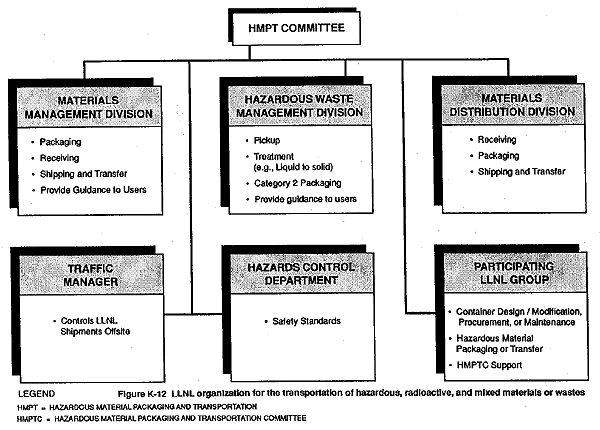
At LLNL, hazardous materials and wastes, including radioactive materials and wastes, are divided into three categories corresponding to an assigned organization area of responsibility:
- Category 1 hazardous materials are "DOE-controlled materials" which include radioactive, hazardous, and classified materials, materials of national interest, and materials of high monetary value, such as precious metals used at LLNL (plus certain hazardous materials defined by DOT regulations, 49 C.F.R. section 171.8). The LLNL Materials Management Division is responsible for control and accountability for onsite transfer, receipt, and preparation for offsite shipment of these materials.
- Category 2 hazardous materials are all unclassified materials of negligible economic value, including hazardous, radioactive, and mixed wastes. These materials are the responsibility of the LLNL Hazardous Waste Management Division.
- Category 3 hazardous materials include all other hazardous materials (not included in Categories 1 and 2). These materials are the responsibility of the LLNL Materials Distribution Division.
Table K-8 Transportation Activity Checklists
| Checklist | Function |
| Hazardous Materials Loading Checklist | Implemented for all onsite transfer of hazardous materials by Materials Management Division, Hazardous Waste Management Division, and Material Distribution Division. |
| Daily Vehicle Inspection Checklist | Safety and equipment checklist for all vehicles that transfer hazardous materials onsite. |
| Receiving/Shipping Checklist | Specific requirements for all industrial gas cylinders received at or shipped from LLNL. |
| Issuing Checklist | Must be implemented prior to issuance of any industrial gas cylinders to users. |
| Hazardous Material Shipping Checklist | Provides a secondary review by the Traffic Management Section of all hazardous material shipped offsite. |
Source: LLNL, 1990a.
K.3.4.1 Materials Management Division
As part of the Safeguards and Security Department, the Materials Management Division is responsible for the receipt, transfer, packaging and shipment of Category 1 controlled hazardous materials, including nuclear and classified materials, mock and actual high explosives, precious metals, and other controlled materials as directed by DOE (LLNL, 1990c). The organization's activities which are key to onsite and offsite transportation of hazardous materials include:
- Preparing shipments of accountable nuclear material and preparing the required documentation for disposal of these materials (Hazardous Waste Management prepares documentation for Materials Management Division review).
- Ensuring that all Category 1 hazardous materials are safely handled, transferred, and stored onsite.
- Ensuring that all packaging and documentation for Category 1 materials meets DOE as well as applicable DOT and NRC regulations for shipping controlled materials, as appropriate.
K.3.4.2 Hazardous Waste Management Division
As part of the Environmental Protection Department, the Hazardous Waste Management Division is responsible for the transfer, treatment, packaging, storage, and shipment of all Category 2 hazardous wastes, radioactive wastes, and mixed wastes generated at LLNL (LLNL, 1989a). The organization's responsibilities, which are key to onsite and offsite transportation, include:
- Packaging and preparing wastes for shipment and disposal.
- Tracking and documenting the onsite and offsite movement of (Category 2) hazardous, radioactive, and mixed wastes from the waste accumulation areas to final disposal.
- Ensuring that containers used for shipping wastes meet DOT and other regulatory requirements.
- Responding to emergencies (secondary response only) and participating in cleanup of hazardous and radioactive spills that may occur at LLNL.
K.3.4.3 Materials Distribution Division
Within the Supply and Distribution Department, the Materials Distribution Division is responsible for receiving, storage, packaging, transfer, and shipping much of the materials used in LLNL programs and facilities including Category 3 hazardous materials at the LLNL Livermore site and LLNL Site 300.
Those Materials Distribution Division responsibilities key to onsite and offsite transportation include:
- Ensuring that all packaging used for shipping for Category 3 hazardous materials meets appropriate DOT specifications.
- Ensuring that all packages of Category 3 hazardous materials received at LLNL comply with regulatory and safety requirements.
- Ensuring that all packages of Category 3 hazardous materials released for offsite commercial or DOE shipment meet regulatory and safety requirements.
K.3.4.4 Traffic Management Section
To improve overall management and coordination of offsite transportation operations, LLNL established the Traffic Management Section within the Supply and Distribution Department as a focal point for all internal and external audits, inspections, and reviews related to hazardous materials and wastes transportation. The traffic management section is specifically responsible for:
- Verifying that all shipments of Category 1, 2, and 3 hazardous materials are properly packaged (including correct labeling and markings).
- Ensuring that proper shipping documentation is complete.
- Ensuring that the carrier is properly certified to transport hazardous materials.
The Traffic Management Section has also completed a review of actions necessary for LLNL to participate fully in DOE's Shipment Movement Accountability Collection (SMAC) system and intends to implement participation during FY 1992. The review assisted in ensuring that LLNL's procurement, accounting, and receiving information system is modified to provide the data required by SMAC.
K.3.4.5 LLNL Onsite Transfer of Hazardous Materials and Wastes
As discussed in section K.3.4, LLNL assigns responsibility for the receipt and onsite transfer of hazardous material and waste depending on whether it falls into Categories 1, 2, or 3 hazardous materials. The LLNL Livermore site receives hazardous wastes from its facility at the Livermore Municipal Airport and from LLNL Site 300. Regardless of which LLNL organization has lead responsibility for managing hazardous materials and wastes, the Laboratory must meet DOE safety requirements for transfer of these materials onsite.
The LLNL onsite packaging and transportation activities are organized to ensure health, safety, and environmental protection. This is accomplished by focusing on three important areas of management, specifically containment, communication, and control of hazardous materials (LLNL, 1991b).
Containment. Providing adequate containment of hazardous materials and wastes during each transfer to ensure no hazardous materials are released during normal onsite transport operations.
Communication. Providing adequate communication to provide sufficient information to personnel handling hazardous materials and (if needed) to emergency responders.
Control. Adherence to documental procedures and other administrative and/or physical control requirements appropriate for the level of containment and communication.
Specific requirements for these areas of activity are applied to the various categories of hazardous materials.
Specific Requirements for Hazardous Materials and Wastes
All three organizations, Materials Management Division, Hazardous Waste Management Division, and Materials Distribution Division, have significant roles in the management and movement of hazardous materials and wastes at LLNL.
Category 1 hazardous materials that arrive onsite are under the jurisdiction of the Materials Management Division which monitors the transfer of these materials to LLNL's programs and facilities. Vehicles and drivers used in transferring Category 1 materials from receiving areas to LLNL facilities must meet LLNL safety requirements including vehicle safety inspections and driving safety training.
All waste materials resulting from the use of Category 1 hazardous materials remain under the jurisdiction of the Materials Management Division. Following inspection and assaying, some of these materials are reassigned to the Hazardous Waste Management Division (e.g., transuranic wastes [see Appendix B], some high explosive wastes, some sealed sources) and become Category 2 materials.
Category 2 hazardous wastes are generated almost entirely at the LLNL Livermore site, although LLNL Site 300 and the LLNL facility at the Livermore Municipal Airport (mainly waste from solvents and similar materials used in servicing the LLNL aircraft) ship hazardous wastes to the LLNL Livermore site for storage or treatment before offsite disposal. (Appendix B discusses the management of hazardous wastes in more detail.)
Hazardous wastes (except medical wastes) are collected and stored temporarily at satellite waste accumulation areas located within work areas. Wastes from a number of satellite waste accumulation areas are collected at larger waste accumulation areas. Table K-9 summarizes the sequence of steps taken at the waste accumulation areas in preparation for onsite transfer and subsequent offsite shipment of hazardous wastes.
The Hazardous Waste Management Division accepts responsibility for transferring hazardous wastes from waste accumulation areas to treatment and storage facilities onsite, providing Waste Technicians to ride in vehicles with drivers provided by the Materials Distribution Division.
The waste technicians are responsible for verifying that wastes in the waste accumulation areas are properly segregated, packaged, and documented before they are transferred to interim storage or treatment. The Hazardous Waste Management Division also is responsible for packaging and preparing shipping papers for the shipment of hazardous wastes (except Controlled Materials waste) for offsite storage, treatment, recycling, or disposal.
Category 3 hazardous materials are primarily those materials used at LLNL that are not "controlled" as in Category 1 or are not waste materials in Category 2. Examples of these materials include flammable and nonflammable compressed gases, corrosives, poisons, and combustible liquids. These materials are usually received at LLNL transported by commercial carriers in DOT-approved packages.
Some users can transfer small quantities of Category 3 hazardous materials from receiving areas to programs and facilities where these materials are used. However, even if users transfer these materials onsite, they must meet LLNL requirements for securing loads, proper packaging and knowledge for proper response in case of an accidental spill. Medical wastes are managed according to procedures in LLNL's Procedure for Handling Medical Waste (LLNL, 1991b).
The Hazards Control Department provides advisory services to LLNL personnel through consulting training, monitoring, and auditing. Hazards Control also provides emergency control services through the Laboratory Fire Department.
Vehicles used in transferring hazardous materials onsite must be equipped with general safety equipment, such as fire extinguishers, "spill kits," and in the case of special hazards such as radioactive materials, with radiation detection equipment. The LLNL motor pool inspects and maintains these vehicles on a regular schedule.
Onsite, LLNL transports containers of solid wastes primarily on flatbed trucks which must pass daily vehicle inspection. Trucks with self-contained pumps are used to pump out temporarily stored liquid wastes in sumps or tanks. Bulk liquids are transported in 350-gal "tuff" tanks or 5000-gal stainless steel or lined steel tank trucks. Smaller liquid containers and tanks are transported on flatbed trucks.
The movement of explosives at LLNL is handled by the Materials Management Division or by LLNL Site 300 Transportation. For onsite movement of explosives at LLNL Site 300, each operating group is responsible for transporting the explosives under its control in approved packaging and vehicles. Hand-carrying of explosives is permitted only when authorized by a safety procedure (Prokosch and Guarienti, 1988).
Specific Requirements for Radioactive Materials and Wastes
Specific procedures for packaging and transporting hazardous wastes are provided in Guidelines for Waste Accumulation Areas (Hirabayashi, 1989). The Hazardous Waste Management Division will only accept wastes that meet the conditions set forth in these guidelines which cover storage functions, including waste segregation, identification, packaging, transportation and spill prevention. Each of these components is an important link in the chain of safe and efficient hazardous waste management.
Radioactive wastes may also be subject to additional packaging and certification requirements for acceptance at an approved DOE disposal site. An example of the certification process is described in the LLNL Transuranic Waste Certification Program (LLNL, 1987), which describes how transuranic wastes would be certified as meeting the requirements for acceptances at the Waste Isolation Pilot Plant in New Mexico, when that facility becomes operational and begins accepting wastes. The plan includes descriptions of the waste certification organization, personnel responsibilities, packaging requirements, data collection needs, and various waste form descriptions (e.g., solidified liquid waste).
Figure K-13 provides a diagram illustrating the onsite transfer of Categories 1, 2, and 3 hazardous materials and wastes at LLNL.
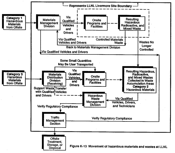
Table K-9 Waste Management Activities at Waste Accumulation Areas Relevant to Transportation
| Waste Preparation Functions | Associated Activities |
| Waste Segregation | Segregation is required because some chemicals may be highly reactive if mixed with others; also, improper mixtures may require special analysis and disposal procedures, which are costly. Radioactive wastes must be segregated from nonradioactive wastes. |
| Waste Identification | Waste generators are responsible for identifying (sampling and analyzing if necessary) wastes before they are picked up by Hazardous Waste Management Division Staff. The identity of waste components must be recorded on a hazardous waste label and attached to each waste container. |
| Waste Packaging | Waste generators are responsible for packaging waste so that it may be safely transported and stored pending disposal. Hazardous Waste Management Division Staff will remove waste from waste accumulation areas only if it is packaged in tightly closed, approved containers that show no signs of damage, deterioration, or leaking. |
| Waste Transportation | Transportation of hazardous waste from the point of generation to the Waste Accumulation Area must be by a method agreed upon between the generator and the Hazards Control Safety Team Leader. Onsite transfer of hazardous waste from Waste Accumulation Areas is done by the Materials Distribution Division with supervision by the Hazardous Waste Management Division. Offsite shipment is provided by DOE or by carriers licensed by the State of California. |
Source: Hirabayashi, 1989.
K.3.4.6 LLNL Offsite Shipment of Hazardous Materials and Wastes
The transport of hazardous materials and wastes offsite must meet federal, state, and local regulations and requirements for packaging; vehicle and driver qualifications; and, in some cases, routing.
Coordination of the offsite shipment of hazardous materials and wastes is the responsibility of the Hazardous Waste Management Shipping Coordinator, who works with the Traffic Management Section to ensure that all packaging and shipments of hazardous material and waste is in compliance with appropriate regulations and DOE orders (LLNL, 1990b). The Coordinator must also:
- Prepare manifests and related shipping documents.
- Prepare reports as required.
- Maintain records as required.
Contractors transporting hazardous wastes from LLNL must be licensed by the state. Trucks carrying hazardous wastes in California are subject to inspections by the California Highway Patrol, both on the highway and at the shipping terminal. Table K-10 provides a summary of the annual number of LLNL offsite shipments of hazardous materials and wastes for the years 1987 through 1990.
Specific Requirements for Explosive Materials
LLNL has designated two areas for receiving and dispatching shipments of explosives between the LLNL Livermore site and LLNL Site 300: Building 191, the High Explosives Applications Facility (HEAF) at the LLNL Livermore site, and Building 818 at LLNL Site 300. All explosives to be shipped offsite are packaged in containers as specified by DOT regulations except when DOE has an approved exemption from the DOT to use different packaging. Shipping containers must also have the appropriate DOT labels affixed.
Only authorized persons may transport explosives and only in approved vehicles. All drivers of explosives-carrying vehicles must have received proper training in the general safety precautions for explosives handling and specialized training for explosives transportation, following the requirements of 49 C.F.R. sections 390–397. In addition, drivers must receive special training that emphasizes caution, road courtesy, and defensive driving (Prokosch and Guarienti, 1988).
Table K-11 summarizes the various controls that drivers must meet in transporting explosive materials. Before vehicles loaded with explosive materials can leave the LLNL Livermore site or LLNL Site 300, drivers must be informed about both the nature of their cargo and methods of fighting vehicle- or cargo-related fires.
In addition, before any motor vehicle may be loaded with explosives (Class A, B, or C) for shipments on public highways, the vehicle must be inspected and approved by a qualified inspector using an approved inspection checklist which is then carried by the driver. Each vehicle transporting explosives is required to carry specialized equipment, such as fire extinguishers and two-way radios. Drivers must also complete the appropriate inspection records to document compliance with these regulatory requirements.
Transportation of explosives on public highways is under the jurisdiction of the California Highway Patrol, which has established approved routes, stopping places, and rules of the road (California Highway Patrol, 1988; 13 C.C.R. sections 1150.1 et seq.). Currently two approved explosives routes exist between the LLNL Livermore site and LLNL Site 300. The first is by way of Corral Hollow Road (west), Tesla Road, and Greenville Road. The second is by way of Corral Hollow Road (east), Interstate 580, and Greenville Road. Because the first route is less congested with traffic, it is the preferred route.
Specific Requirements for Radioactive Materials and Wastes
For offsite transport, radioactive materials and wastes must comply with DOE and DOT packaging requirements (DOE Order 5480.3 and 49 C.F.R. section 173). Transuranic (TRU) wastes are subject to the additional packaging and certification requirements to qualify them for long-term storage and eventual disposal at a DOE-licensed facility. This certification program plan is described in the LLNL Transuranic Waste Certification and Quality Assurance Plan (LLNL, 1990b).
All waste shipments expected to be consigned to the Nevada Test Site will be made in accordance with applicable DOT, EPA, state, and local hazardous materials regulations and with DOE requirements contained in the Nevada Test Site waste acceptance criteria (DOE, 1988). These requirements include DOT placarding requirements (49 C.F.R. section 172). Also, all mixed-waste shipments will be in accordance with the DOT's "Standards Applicable to Transporting of Hazardous Waste" (40 C.F.R. section 263).
DOE safe, secure transports (SSTs) are used for offsite shipment of classified special nuclear materials, including classified device parts when required. The SSTs are a ground transportation system with "built-in deterrent and disabling devices and special electronically coded locks set in vault-like doors" (DOE, 1990b). These systems are operated by specially selected and trained personnel. The transport systems must comply with DOE requirements and appropriate DOT regulations (49 C.F.R. sections 170–179).
Table K-10 Annual Number of LLNL Offsitea Hazardous and Radioactive Materials and Wastes Shipments for 1987-1990b
| Hazardous Materials Land Wastes | 1987 Shipments | 1988 Shipments | 1989 Shipments | 1990 Shipments |
| Explosives | 8 | 53 | 47 | 12 |
| Nonflammable Gas | 23 | 41 | 47 | 66 |
| Flammable Gas | 3 | 5 | 10 | 8 |
| Flammable Solid | 8 | 25 | 27 | 5 |
| Oxidizer | 1 | 0 | 5 | 2 |
| Poison | 1 | 3 | 14 | 9 |
| Corrosive Materials | 1 | 14 | 15 | 8 |
| Hazardous Wastes | 9 | 49 | 70 | 175 |
| Combustible Liquids | 0 | 0 | 0 | 2 |
| Flammable Liquids | 3 | 22 | 22 | 10 |
| Radioactive Materials Empty Packaging | 32 | 42 | 28 | 29 |
| Radioactive Materials—Other | 82 | 114 | 132 | 95 |
| Radioactive Waste for Burial | 12 | 0 | 2 | 0 |
| Highway Route Controlled Radioactive Materials | 2 | 5 | 9 | 7 |
| Total: | 181 | 373 | 428 | 426 |
a Includes shipments to and from LLNL Site 300.
b Does not include vendor pickups of
hazardous materials (e.g., compressed gases), which LLNL estimates to be
approximately 250 shipments annually. Source: LLNL, 1991d.
Table K-11 Safety Controls on Drivers of Vehicles Carrying Explosive Materials
| Driver Controls: |
|
|
|
|
|
|
|
Source: Derived from Prokosch and Guarienti, 1988.
K.3.5 SNL, Livermore Organization for Transport of Hazardous Materials and Wastes
In 1990, SNL, Livermore reorganized its administration of packaging and transportation of hazardous materials and wastes, creating several new divisions with responsibilities to ensure adequate self-assessments and independent oversight to meet the requirements of DOE Orders 5480.1 and 5482.1B. In addition, SNL, Livermore has instituted an oversight program to ensure that line organizations comply with DOE and SNL, Livermore hazardous material policies and procedures. SNL, Livermore also requires its vendors and/or suppliers to adhere to all relevant onsite health and safety regulations; for example, the labeling of cryogenic (i.e., very low temperature) storage tanks onsite (SNL, Livermore, 1991b).
SNL, Livermore has also instituted a comprehensive training program for hazardous materials packaging and transportation, which provides job task analysis, individual training records, performance measures, and frequency of training requirements. Personnel are scheduled to attend training sessions to support the program requirements. In addition, a training database has been developed to track past and future training session attendance and to identify future training needs (SNL, Livermore, 1991b).
For improved safety, SNL, Livermore has revised its Spill Prevention, Control and Countermeasures plan and program to meet the requirements of DOE Orders 5480.1B and 5480.4, and federal regulations contained in 40 C.F.R. section 112. The plan includes specific procedures, forms, and checklists for use by maintenance personnel and has been used in developing a training program for fire-fighting personnel. SNL, Livermore has also prepared a hazardous materials quality assurance plan to address the onsite transportation and handling of hazardous materials. The plan references procedures such as proper grounding of flammable liquid drums and cargo loading and securing procedures (SNL, Livermore, 1991b).
To ensure compliance with DOE Order 5480.3, including procedures for preparing, packaging, and transporting offsite shipments of hazardous materials, SNL, Livermore has developed the Transportation Safety Manual identifying responsibilities, lines of authority, and program approval procedures. The manual further defines minimum safe packaging and training requirements and provides for compliance of regulatory vehicle standards and driver qualifications for the transport of hazardous materials. The manual also provides information about emergency response procedures (SNL, Livermore, 1991d).
Periodic training is coordinated with the security inspector force to raise awareness of hazardous material movements onsite. Vehicles moving hazardous materials onsite are equipped with driver-side door pockets that display the hazard class cards applicable to the hazards on board the vehicle. When transferring hazardous materials, the driver selects an appropriate hazard class card from the door pocket and attaches it to a clipboard kept in the vehicle. In case of an emergency, this card provides readily available information on the nature of the hazardous materials being transferred. SNL, Livermore has revised its quality assurance plan along with the supporting procedures to include offsite and onsite packaging and shipping. This process would be supported by a series of internal audits of the packaging and transportation programs (SNL, Livermore, 1991b).
In support of transportation emergency response capacity, the telephone system at SNL, Livermore's Security Control Center has been upgraded to accommodate up to six callers conferenced at one time. SNL, Livermore has also revised its incident response procedures to ensure its communication capabilities to respond to a transportation emergency involving hazardous materials.
K.3.5.1 SNL, Livermore Onsite Transfer of Hazardous Materials and Wastes
SNL, Livermore's onsite transportation manual (SNL, Livermore, 1991a) and Transportation Safety Manual (SNL, Livermore, 1991d) include procedures for managing the transfer of hazardous materials and wastes. These procedures are consistent with federal regulations and DOE Orders for offsite shipment of hazardous materials and wastes, including:
- Marking the outside of the packaging.
- Labeling the outside of the packaging, whenever possible, with a proper DOT label.
- Packaging the materials or wastes properly.
- Documenting the movement with proper records.
- Placarding transport vehicles following procedures outlined in the manual.
Hazardous materials, with the exception of explosives, are received onsite through the Property Management Division which has responsibility for transferring these materials to onsite programs and facilities. Handlers and delivery personnel responsible for moving hazardous materials must undergo training in the hazards and safety procedures related to the types of materials they work with (Yourick et al., 1989). A summary of these training requirements is presented in Table K-12.
Hazardous wastes generated at SNL, Livermore become the responsibility of the Environmental Protection Department. There are several classes of wastes managed at SNL, Livermore (see Appendix B for a more detailed discussion of hazardous wastes) (SNL, Livermore, 1991d):
- Hazardous chemical wastes, which include RCRA, Toxic Substance Control Act, and California Regulated Wastes.
- Radioactive wastes, which include predominately low-level tritiated (contaminated with tritium) waste (e.g., paper, oil absorbed into clay, or liquid oil) and depleted uranium.
- Mixed wastes, which include a combination of hazardous and radioactive wastes (see Table K-6).
- Medical wastes, which include biohazardous waste and sharps waste (e.g., needles, blades and glass slides).
- Nonsewerable industrial waste water, which is not designated as either hazardous or radioactive waste but is managed as hazardous waste.
Once hazardous wastes are properly identified packaged, marked, and labeled (according to 49 C.F.R. sections 100–177 and 40 C.F.R. sections 260–268), a trained hazardous waste technician loads, secures, and transfers the wastes in a qualified vehicle, specifically designed for this work. The wastes are stored in a secure EPA-permitted waste management facility. The vehicle used to transport waste onsite is equipped with a CB radio tuned to the site security communication center. At no time does the vehicle carrying waste use a public road for these onsite transfers (SNL, Livermore, 1991d). Figure K-14 shows the flow of hazardous materials and wastes onsite at SNL, Livermore.
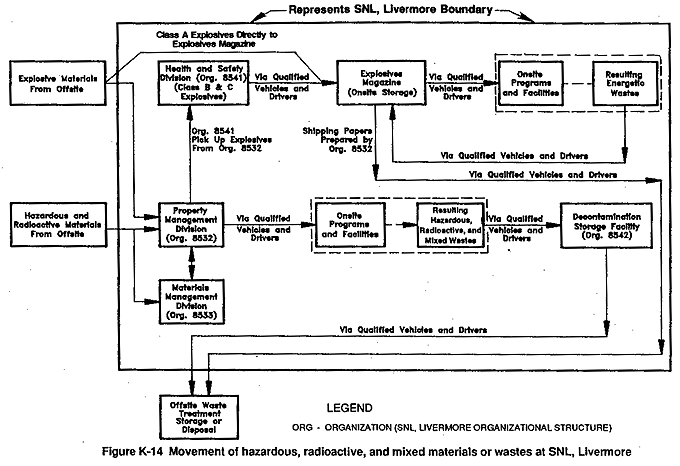
Specific Requirements for Explosives
Class A explosives are received by the Health and Safety Division at one onsite location (Building 981) by qualified explosives handlers. Class B and C type explosives may be received at an alternative building location (Building 928) for later transfer by qualified explosives handlers. All explosives are packaged for shipment by explosives handlers only in authorized explosives areas. Bulk compressed gas is also received at a single onsite location (Raw Stock in Building 918) from which it is distributed to a requesting organization. Outbound compressed gas must also go through this facility.
Specific Requirements for Radioactive Materials
At SNL, Livermore, only designated persons are authorized to transport radioactive materials onsite (Yourick et al., 1989). The extent of packaging for radioactive materials depends on the quantity of material involved and the radiation level at the external surface of the package. Packaging varies with the particular radionuclides to be transported, and determination of packaging type for a particular radioactive material shipment follows a detailed process of matching radionuclide activity levels with the appropriate shielding and safety requirements.
Table K-12 SNL, Livermore Hazardous Materials Training Requirements
| Training Requirements: |
|
|
|
|
|
|
|
|
|
|
|
|
Source: Yourick et al., 1989.
K.3.5.2 SNL, Livermore Offsite Shipment of Hazardous Materials and Wastes
With the exception of explosives and bulk compressed gas, outbound hazardous materials and wastes are picked up by shipping personnel and delivered to a single onsite location for packaging for offsite shipment. Occasionally, for security reasons, Nuclear Explosive–Like Assemblies are prepared for shipment (collected, placed in containers, marked and labeled) at Test Assembly Group locations. All shipments of hazardous materials and waste offsite must comply with DOT regulations.
SNL, Livermore prepares hazardous, radioactive, and mixed wastes for offsite transportation at the Waste Management Facility (Buildings 961 and 9622) where wastes are properly packaged, marked, and labeled according to DOT and EPA regulations. Table K-13 lists the number of hazardous and radioactive materials and wastes shipments offsite from 1987 to 1990. Before waste containers are shipped offsite, they are further inspected by Hazardous Waste Management staff for compliance with closure, strength, handling, devices, size, and weight requirements by DOT and disposal-site waste acceptance criteria.
Specific Requirements for Explosives
The shipping of explosives is monitored by the California Highway Patrol (see section K.3.3). In addition, as required by DOE orders, all packaging, labeling, applicable shipping documents, and transportation requirements must comply with DOT regulations (49 C.F.R. sections 100–179). Only designated personnel are authorized to transport explosive materials. The proper packaging according to DOT requirements along with the marking, labeling, vehicle placarding, and records documentation must be followed.
Specific vehicles are dedicated for transporting explosives and are equipped according to DOE Explosives Manual requirements. Each vehicle must be inspected daily before use by the operator and inspected monthly by the section supervisor. Records must be kept of these inspections. In addition, materials to be transported on the same vehicle must be compatible.
Table K-13 Annual Number of SNL, Livermore Offsite Hazardous, Radioactive, and Mixed Material or Waste Shipments for 1987-1990*
| Hazardous Radioactive,and Mixed Materials or Wastes | 1987 Shipments | 1988 Shipments | 1989 Shipments | 1990 Shipments |
| Explosives | 110 | 120 | 91 | 44 |
| Nonflammable Gas | 55 | 37 | 81 | 82 |
| Flammable Gas | 19 | 49 | 21 | 34 |
| Flammable Solid | 23 | 31 | 22 | 8 |
| Oxidizer | 0 | 0 | 1 | 1 |
| Poison | 10 | 11 | 8 | 18 |
| Corrosive Materials | 7 | 17 | 51 | 68 |
| Flammable Liquids | 7 | 6 | 9 | 10 |
| Radioactive Materials (No Label Required) | 30 | 56 | 42 | 28 |
| Radioactive Materials (White Label Required) | 7 | 7 | 8 | 11 |
| Radioactive Materials (Yellow Label Required) | 17 | 23 | 26 | 13 |
| Otherwise Regulated Materials (ORM) A, B, D, and E | 10 | 13 | 3 | 5 |
| Hazardous Waste | 10 | 12 | 22 | 39 |
| Radioactive Waste | 1 | 0 | 0 | 1 |
| Mixed Waste | 0 | 0 | 0 | 2 |
| Total: | 306 | 382 | 385 | 364 |
* SNL, Livermore shipment data includes hazardous materials shipments picked up by vendors (e.g., compressed gas cylinders). Source: SNL, Livermore, 1991c.
|
NEWSLETTER
|
| Join the GlobalSecurity.org mailing list |
|
|
|