

Mojshekan - Breakwater Harbors
| location | number |
|---|---|
| Caspian Sea | 4 |
| IRGCN Region 3 | 1 |
| IRGCN Region 2 | 8 |
| IRGCN Region 4 | 23 |
| IRGCN Region 5 | 18 |
| IRGCN Region 1 | 29 |
| Gulf of Oman | 21 |
| TOTAL | 104 |
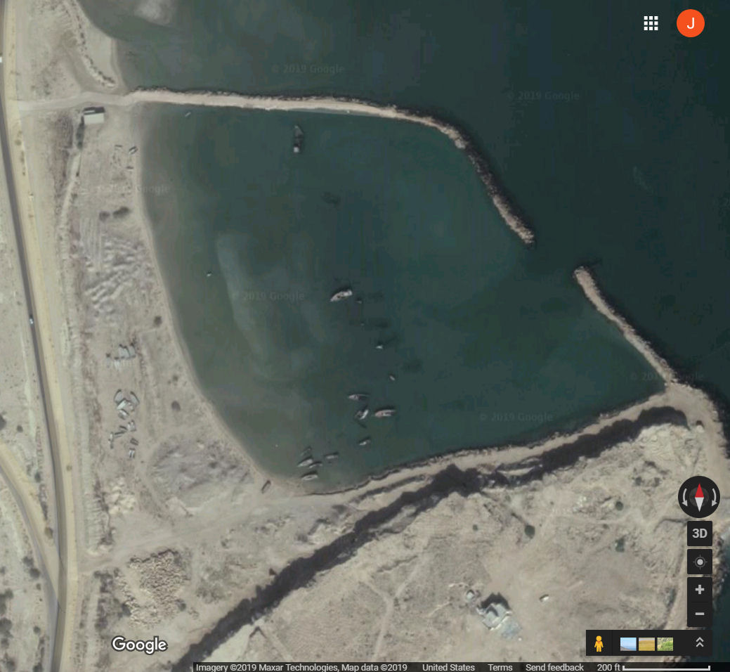
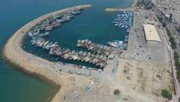
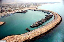
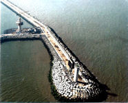
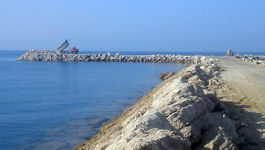
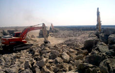
The mojshekan are almost exactly 100 in number, depending on how they are counted. They are mainly located in the southern part of the Persian Gulf, and on the coast of the Gulf of Oman. Some are small, possibly 100 meters by 100 meters, and others are rather larger, several hundred meters on a side. The construction chronology of these breakwaters is not attested in readily available open sources. Under the 1963 White Revolution, the national development program of Mohammad Reza Pahlavi, Iran's last king, the state assumed responsibility for dam and irrigation projects, heavy industry, and the construction of roads, airports, and harbors. It is reasonable to believe that these breakwaters were initially constructed by the Shah, and subsequently maintained by the Islamic Republic. In any event, there is no recent literature hailing the construction of these breakwaters as a great achievement of the Islamic Revolution, the existing structures all appear to be of about the same age and done under a single hand, and the whole enterprise is the sort of brobdingnagian scheme one might expect from the Shah.
 Nearly all breakwaters are designed on the basis that it is cheaper to have to repair them occasionally than to design and construct them to withstand some maximum hypothesized event. Breakwaters suffer damage through the action of storm waves. Generally the damage as observed from the surface appears to be much greater than it actually is. The material moved by wave action off the above water portion of a breakwater has been moved either over the top of the breakwater and deposited on its lee side, or has been moved down the breakwater slope on the ocean side. On some occasions the rock and whole or broken pieces of cast concrete armor units are moved up the ocean side slope to form a rubble berm near the top of the breakwater. Breakwaters are usually repaired within a few years after the damage has occurred. All but one of the Iranian breakwaters appear in good repair, the one exception being a visibly forlon harbor at Bandar e Suza where old ships are left to sink and rot.
Iran's network of Mojsheka / breakwater ports may be classified according to several variables:
- Active mojshekan have significant numbers of vessels anchored within the breakwater, while inactive breakwaters are devoid of shipping.
- Isolated mojsheka are located at some distance from settled areas, and have no apparent association with settlements, while adjacent breakwaters are located next to settlements.
It might be assumed that isolated breakwaters are always inactive, while adjacent breakwaters are always active, but nothing in Iran is so simple.
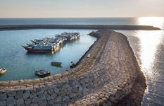
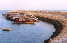
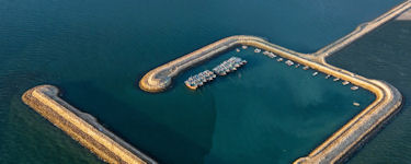
The more active breakwater harbors are typically populated by dozens if not hundreds of small vessels, ranging in length from a few meters to a few dozen meters. Almost all are presumably fishing dhows. Most of the mojshekan are populated by no more than a dozen or two craft, and some are entirely devoid of any shipping.
The empty breakwaters are something of a puzzle. For some, the absence of activity may represent an un-representative snapshot. Some may be part of a business plan gone sour, part of a development strategy that is currently becalmed. In constrast to the active harbors, which are adjacent to settlements, the inactive harbors are typically far from urban areas. Indeed, some are very far from civilization and out in what can only be described as a howling wilderness.
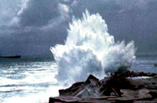
Possibly some of the isolated empty breakwaters are storm havens, the only purpose of which is to offer shelter from storm to small craft caught far away from home port. The Gulf coast of Iran lies quite open to the Shamal storm winds and is a dead lee-shore in a Na'shi storm. Inclement weather may affect small craft operations due to an inability to safely launch and recover such craft or to lift payload packages in and out of the water with cranes on a rig. For example, rough seas and high winds may cause loads to swing excessively, which may prevent personnel from safely working on deck. As such, until the inclement weather passes, the flotilla must shut down, which may be very inconvenient.
A Storm Haven for Small Craft, the phrase "any port in a storm" indicates accepting help from anyone who will give it, regardless of the source. When in difficulty you need not to seek the perfect solution; any solution will suffice. The first known use of this proverb is in the English author John Cleland's bawdy novel Memoirs of a Woman of Pleasure, 1749: "Pooh!", says he "my dear, any port in a storm." Cleland's book is better known as Fanny Hill. The content of the book is, in the words of Mary Whitehouse, the founding president of the UK National Viewers' and Listeners' Association and campaigner against the permissive society, "utter filth". Cleland goes to elaborate lengths to describe the events in the story, which are by any standards exceedingly lewd, in euphemistic language.
In September 2008 the IRGCs naval forces assumed responsibility for defending Irans interests in the Persian Gulf, while the Iranian Navy has been tasked with defending Irans interests and boosting its presence in the Gulf of Oman and the Caspian Sea. Although claims about its weapons and capabilities are clearly exaggerated, the IRGC Navy has the capability to conduct hit-and-run operations and direct many of its speedboats at civilian and naval targets primarily in the Hormuz choke point, using swarming tactics. The IRGC relies on strength in numbers and surprise. The vessels of this navy can rapidly disperse and shelter in small inlets, small fishing ports and hardened sites.
Breakwaters are structures designed to provide calm at the harbor, to ensure the safe entry of ships into the waterways and ports, reduce the energy generated by waves, and protect beaches against waves. Breakers are classified from different perspectives including geometric shape, materials, and positioning to different types. Among the types of crushers in terms of geometry and materials, rock mass crackers are among the most common types.
Over the past 50 years, rock massive rocket cracks were built in shallow waters. With the increase in the exchange of goods, the necessity of expansion of ports and the extent of them and the increase of the dimensions of the vessels caused the breakwaters to be built at greater depths and open spaces, which led to an increase in the height of the waves and the introduction of design and implementation issues. In this regard, The types of breakwaters are considered for structural and sustainability. Designers, with the construction of breakwater structures in deeper water and places exposed to higher waves, found that they should increase the amount of rock needed to reach the stable profile .The use of large stones at the external surface of the structure reduced the required volume to a large extent.
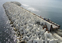
The advances made in concrete technology in the early 19th century replaced subterranean concrete blocks rather than large rocks. However, due to the need for the construction of breakwaters in places exposed to higher-wavelength wavelengths, the construction and displacement of unused concrete components was impracticable. Finally, the application of concrete components with irregular shapes with multiple bases has become widespread. The stability of these components against wave attack in addition to weight, due to the involvement (pairing) of adjacent parts is achieved.
A breakwater is an offshore shore-parallel structure that breaks waves, reducing the wave energy reaching the beach and fostering sediment accretion between the beach and the breakwater. Made of rock, concrete, or oyster shell, these structures can be floating or fixed on the ocean floor and can be continuous or segmented. Breakwaters can be placed attached to the shoreline as headlands or submerged near the shoreline as sills.
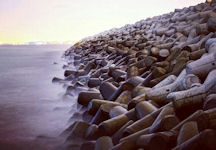
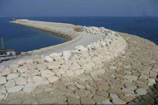
The Iranian breakwaters are composed of "Rip Rap", a layer of broken rock, cobbles, boulders, or fragments of sufficient size to resist the erosive forces of flowing water and wave action. A riprap revetment is a sloping structure consisting of layers of stone or other material generally composed of smaller "core stone" covered with at least 2 layers of larger stone, including an "armor" layer of the largest stone needed for the particular wave conditions at the site. Riprap can be concrete rubble, granite stone or other material used to build the revetment. Riprap is used to prevent erosion in the same manner as a vertical bulkhead but has the added advantage of being able to dissipate most wave energy rather than merely reflect it as with vertical structures.
Revetments typically use large rocks or concrete armor units to dissipate wave energy and prevent further recession of the shoreline. Because the individual units are susceptible to movement under the right combination of forces, revetments are most effective in low-moderate wave conditions. The sloping, porous nature of revetments reduces the amount of energy reflected from the structure compared to vertical or impervious structures. This can lessen the amount of scour experienced at the base and along the flanks of the structure. Revetments differ from rip-rap protected slopes in that the material utilized is often larger, more uniform, and designed to resist a higher level of wave energy.
A jetty is a structure extending into the water to direct and confine river flow into a channel and to prevent or reduce shoaling of the channel. Jetties are structures designed to modify or control sand movement. A jetty is generally employed at inlets for the purpose of navigation improvements. When sand being transported along the shoreline by waves and currents arrives at an inlet, it flows inward on the flood tide to form an inner bar, and outward on ebb tide to form an outer bar. Both formations are harmful to navigation through the inlet. A jetty is usually constructed of steel, concrete or rock. The type depends on foundation conditions and wave, climate and economic considerations. To be of maximum aid in maintaining the navigation channel, the jetty must be high enough to completely obstruct the sand stream. The adverse effect of a jetty is that sand is impounded at the updrift jetty and the supply of sand to the shore downdrift from the inlet is reduced, thus causing erosion.
At first glance, breakwaters, jetties and groins appear to be similar structures, but they are each unique in their location and function. In comparison to a breakwater, jetties are considerably smaller and are not primarily used to reduce wave action. Jetties are designed primarily for sediment management and are typically located at the mouth of a river. Breakwaters are typically found surrounding a harbor facility as they are primarily designed for limiting wave action. Groins are shore-perpendicular structures, often smaller than jetties, and are intended to trap sediment as a means of erosion control, and are therefore not found at harbors or river mouths.
Most commonly found around harbors, breakwaters allow for safer ship passage and cargo handling while providing overall protection of the harbor facilities. Breakwaters may also be used at a harbor to direct currents and reduce the build-up of sediment within the shipping channel. These structures may also be found around the water intake facilities of energy plants. Breakwaters around harbors are large structures constructed of armor stone or pre-cast concrete modules. Usually navigational safety items are located at the lakeward end. Sometimes the navigational item is a small lighthouse to warn of the structures location or a more simplified guidance buoy directing ships into the harbor. When located around the water intake and discharge of energy facilities, breakwaters are constructed of the same materials, armor stone or pre-cast concrete modules.
|
NEWSLETTER
|
| Join the GlobalSecurity.org mailing list |
|
|
|