

Uttarakhand - Geography
 Such is the profound beauty of the place, that it provoked Mahatama Gandhi to call this place the Switzerland of India. Cozily snuggled in the arms of the great Himalayas, the state of Uttarakhand has time and again been referred to as Dev Bhumi or The Land of Gods. Uttrakhand is a part of the Western Himalayan ranges, which start from the Siwalik foothills to Greater Himalayas with Tibet as its north-eastern border.
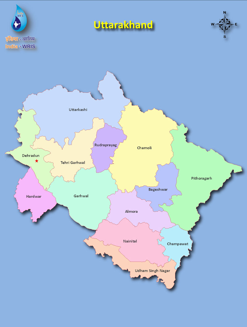
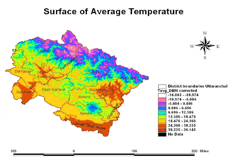
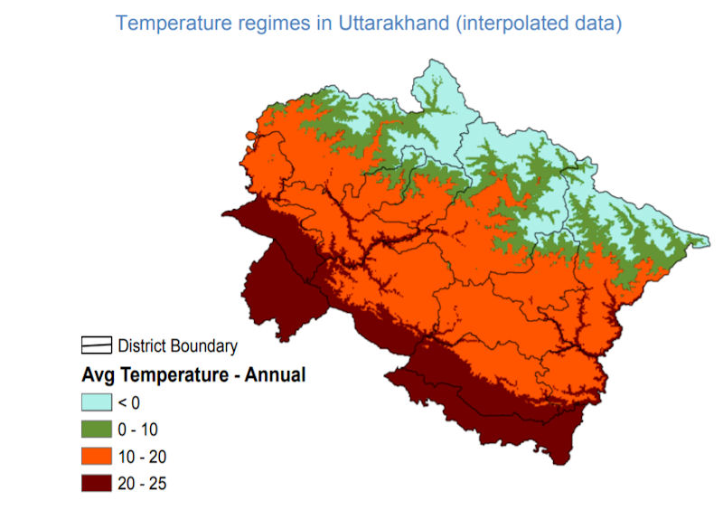
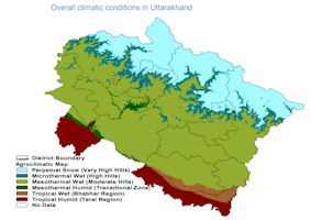
In the north-western corner of the state is Himachal Pradesh, Haryana in the west, Tibet China in north, Nepal in east and Uttar Pradesh surrounds western & southern boundary of the state. Dehradun is the state capital. Uttarakhand has a mountainous topography while temperature has a direct relationship with height of a place above the mean sea level i.e. temperature decreases with increases in altitude. Therefore, the state experiences a wide range of temperature variation.
Resting majestically in the Garhwal Himalayas is a twin-peaked massif that forms a long high ridge leaning east to west, known as Nanda Devi. The Nanda Devi East Peak is part of this, and together with the West Peak, are formed the twin peaks of the Goddess Nanda. A barrier ring guards the main summit, within which can be found some of the highest mountains in the Indian Himalayas, and Nanda Devi East is one of them. Twelve peaks surpass 6,400 meters in height. The heart of the insurmountable ring is the Nanda Devi Sanctuary which is protected as the Nanda Devi National Park. Nanda Devi East lies on the eastern edge of the ring and of the Park; at the border of Chamois, Pithoragarh and Bageshwar districts. The Nanda Devi West Peak towers at 7,817 meters and is the second highest in the country.
The streams that originate in the deepest hideaways of the glorious Himalayas of Uttarakhand flow on to feed rivers which have nourished a civilization that has been born and brought up in the Indo-Gangetic soil of the country. These rivers are not just water bodies of enormous proportions, but are also impressive streams commanding worship and reverence with their source in the holy crevices where gods and goddesses reside.
The water of the holiest of all Hindu rivers, the Ganga, is believed to wash away and purge the body, mind and soul of all impurity. The holiest of all Hindu rivers, the Ganga, gushes from Gaumukh in the Gangotri Glacier and flows on to nourish the soils of the Indo-Gangetic plain, whilst bringing people closer. A dip in the holy waters of the Ganga promises to wipe the souls slate clean of all sin. The confluences of rivers are considered to be extremely important sacred places to which millions of devotees flock every year.
The Ganga river system drains a large chunk of the Himalayas right from the eastern slopes of the Shimla ridge to eastern Nepal, which is actually the central Himalayas that incorporates the Kumaon and Garhwal regions. With its famous tributaries, the Yamuna and Kali, three smaller river systems are formed, namely the Yamuna system, the Ganga system and the Kali system. The river in its upper stages is known as Bhagirathi. As it flows down, it acquires different names crowned with religious significance. Before merging with the ocean, the river divides itself into several streams and drains into the Bay of Bengal. Also merging with the Ganga here is the River Brahmaputra.
The lush green forests of this region are home to an astounding multiplicity of flora and fauna, some of which fall into the category of endangered species. The wildlife bursts with hundreds and thousands of species, making an exploratory trip to Uttarakhand even more exciting, in the light of the fact that many species are yet to be discovered.
World-renowned mountain and wildlife institutes, national parks and forest reserves in this region pursue scientific research putting in enormous efforts to preserve and protect the lands bounty, encouraging people to participate in this noblest of causes.
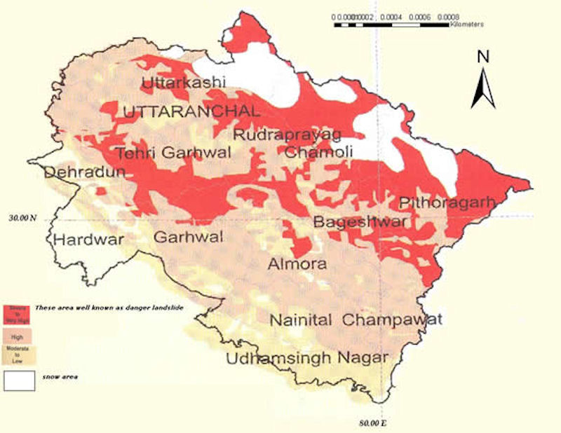
Uttarakhand by virtue of its geographical setting is vulnerable to minor ecological changes. Hence any activity disapproved by mountain ecosystem triggers a disaster. It is not possible to stop disasters from happening, but people certainly take some steps to reduce its effects. Disasters are synonymous to damage of property, life and psyche of the people. If disasters cannot be averted, then reduction of losses of any type, caused by disaster becomes a focal point of the policy for disaster management.
In the recent years (1990 onwards) Uttarakhand has experienced two major earthquakes (magnitude >6) in Uttarkashi(1991) and Chamoli (1999) and a series of landslides/cloud burst such as Malpa (1998), Okhimath (1998), Fata (2001), Gona (2001), Khet Gaon (2002), Budhakedar(2002), Bhatwari (2002), Uttarkashi (2003), Amparav (2004), Lambagar (2004), Govindghat (2005), Agastyamuni (2005) Ramolsari (2005) and many more.
Uttarakhand is a disaster prone state. Landslides, forest fires, cloudbursts and flash-floods are seasonal in nature and these strike at a certain period of the year with high frequency. Earthquake is the most devastating disaster in the mountains and are unpredictable.


|
NEWSLETTER
|
| Join the GlobalSecurity.org mailing list |
|
|
|