

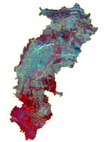
Chhattisgarh - Geography
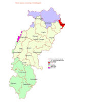
 Chhattisgarh is located in the heart of India, and shares its borders with six States of the country; Uttar Pradesh to the north, Jharkhand to the north-east, Orissa to the east, Madhya Pradesh to the west and north-west,
Maharashtra to the south-west and Andhra Pradesh to the south-east. The geographical area of the State covers over 135,000 square
kilometres and the total population in 2001 was 20,833,803 (2.08 crores1).
Chhattisgarh is located in the heart of India, and shares its borders with six States of the country; Uttar Pradesh to the north, Jharkhand to the north-east, Orissa to the east, Madhya Pradesh to the west and north-west,
Maharashtra to the south-west and Andhra Pradesh to the south-east. The geographical area of the State covers over 135,000 square
kilometres and the total population in 2001 was 20,833,803 (2.08 crores1).
Chhattisgarh is situated between 17 to 23.7 degrees north latitude and 8.40 to 83.38 east longitude. (The Tropic of Cancer runs through the State). The climate of Chhattisgarh is mainly tropical, humid and sub-humid. The Mahanadi is the principal river of the State. The other major rivers are - Sheonath, Hadeo, Mand, Eeb, Pairi,Jonk, Kelo Udanti, Indrawati, Arpa and Maniyari.
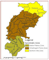
Chhattisgarh can be divided into three distinct regions To the north lie dense forests, hills and water reservoirs. The districts that are part of this region are Korea, Surguja, Jashpur, Raigarh, and Korba. These districts have similar geographical, climatic and cultural conditions. Many of the indigenous tribes like the Paharikorba and the Pando live in these areas. Life here is governed by tribal customs, culture and traditions. In the rural areas of the region, people are dependent largely on agriculture and minor forest produce. Due to the available natural resources, the level of migration from this region is comparatively limited. There are no urban centers except Korba and Ambikapur. Korba is the largest town, and the limited industry is concentrated here. There are coal mines in Surguja and Korea districts.
The districts that fall in the central plains region are Raipur, Bilaspur, Janjgir-Champa, Kabirdham, Rajnandgaon, Durg, Dhamtari and Mahasamund. The river Mahanadi flows through the area and meets the ever-increasing water requirement of the region, for irrigation and domestic use. The central plains of Chhattisgarh are known as the rice bowl of Central India, because of the large number of indigenous varieties of rice that are grown here. Bhilai and Durg are well known urban centres, both with large steel plants. There are a large number of rural artisans in this region, and the silk weavers of Janjgir-Champa are well known. The region is densely populated. Raipur and Durg account for almost half the total urban population of Chhattisgarh. The other districts, apart from Bilaspur and Rajnandgaon, have less than six percent of the urban population.
The southern region of Chhattisgarh is known for its varied and rich forests, its diverse tribal population and unique culture. The districts in this region are Kanker, Bastar and Dantewada. These districts are bordered by the States of Maharashtra, Andhra Pradesh and Orissa. The people of the region are dependent on traditional agriculture and forests for their livelihood. The Bailadila mines in Dantewada district represent the limited industry in the region.
Chhattisgarh is a land blessed with a pleasant climate as well as a priceless heritage that has sustained and nourished its people through the ages. The State has rich resources including land, forests and water. These abundant resources are of high quality and are spread across the State, allowing an exceptional degree of access and availability.
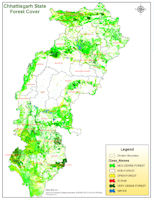
The forests of the State are of two major types: tropical moist deciduous and tropical dry deciduous. Most of the dense forests are concentrated in the northern (Surguja, Korea, Jashpur and Korba districts) and the southern regions of the State (Bastar, Kanker and Dantewada districts). These areas also have large tribal populations. The plains of the central region of the State have much less forest cover. In this region, the dependence on agriculture and therefore on land as a source of livelihood is much higher.
In the plains of Chhattisgarh, land and water are seen as the primary resources. For the people of the hill tracts in the north and the south of the State, water and the forests are the critical resources, seen as the key to survival, sustenance and advancement. The availability of water resources is better in the north and the south of the State. Similarly forests and common property resources such as land are also more plentiful in these regions.
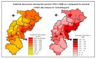
Chhattisgarh abounds in water bodies rivers and streams, lakes and tanks (dabrees). It also receives, in normaly ears, rainfall adequate to replenish water resources, and to meet the needs of the people. The annual average rainfall varies between 1200 mm to 1400 mm. Despite the abundance of water, people have learnt to conserve water, and use it judiciously and equitably, through systems and practices that have evolved over hundreds of years. A combination of wisdom, intuition and experience enables the people to tide over situations of adversity the preceding years of drought and poor monsoon provide an excellent example of how the people survive difficult times.
The State of Chhattisgarh forms part of the extended river basin of four major rivers the Mahanadi, Godavari, Narmada and the Ganga. The combined river length flowing through the State is 1,885 kilometres. These rivers provide a large network of surface water and support the primary sources of irrigation in the State. There are also smaller rivers and tributaries, seasonal nallahs and natural springs. It is estimated that surface water available for use is 41,720 million cubic metres (mcm). The State has three major, 30 medium and 2,017 minor irrigation projects maintained by the Water Resources Department. Small tanks are maintained by the Panchayats.
The land area of Chhattisgarh is about 1.35 lakh square kilometres. About 36 percent of the area is cultivated, and another 44 percent is under forests (forest land and revenue forests). Of the total land area in the State, 4,828 thousand hectares are sown, and the net sown area 13 per head is 0.24 hectares. The gross sown area is 5,327 thousand hectares. The highest percentage of land under agriculture is in Durg, Janjgir-Champa, Mahasamund (all above 50 percent), followed by Raigarh, Bilaspur, Kabirdham, Rajnandgaon and Raipur (all above 40 percent). The lowest percentage of net sown area to total area, is in Korea (18.7 percent), followed by Dakshin Bastar Dantewada (19 percent) and Bastar (21 percent).
Chhattisgarh has at least five different types of soil. In the districts of Bilaspur, Surguja, Durg, Raipur and Bastar red and yellow loamy soil is dominant. Both are low in nitrogen and humus content. A major part of paddy production comes from this region. In the hill ranges, the soil is sandy loam, which is also suitable for paddy. Laterite soil is good for cereal crops, while the black soil is best suited to cotton, wheat and gram.
Chhattisgarh is rich in mineral resources. Vast reserves of coal, iron ore and bauxite are found here, along with limestone and dolomite. This is the only State in the country where tin ore is found. Diamonds and semi precious stones like corundum, quartz and garnet are also mined here. While mining provides employment to some people and substantial revenue to the State, the industry has an adverse impact on the environment in some districts.


|
NEWSLETTER
|
| Join the GlobalSecurity.org mailing list |
|
|
|