

Tarim Basin
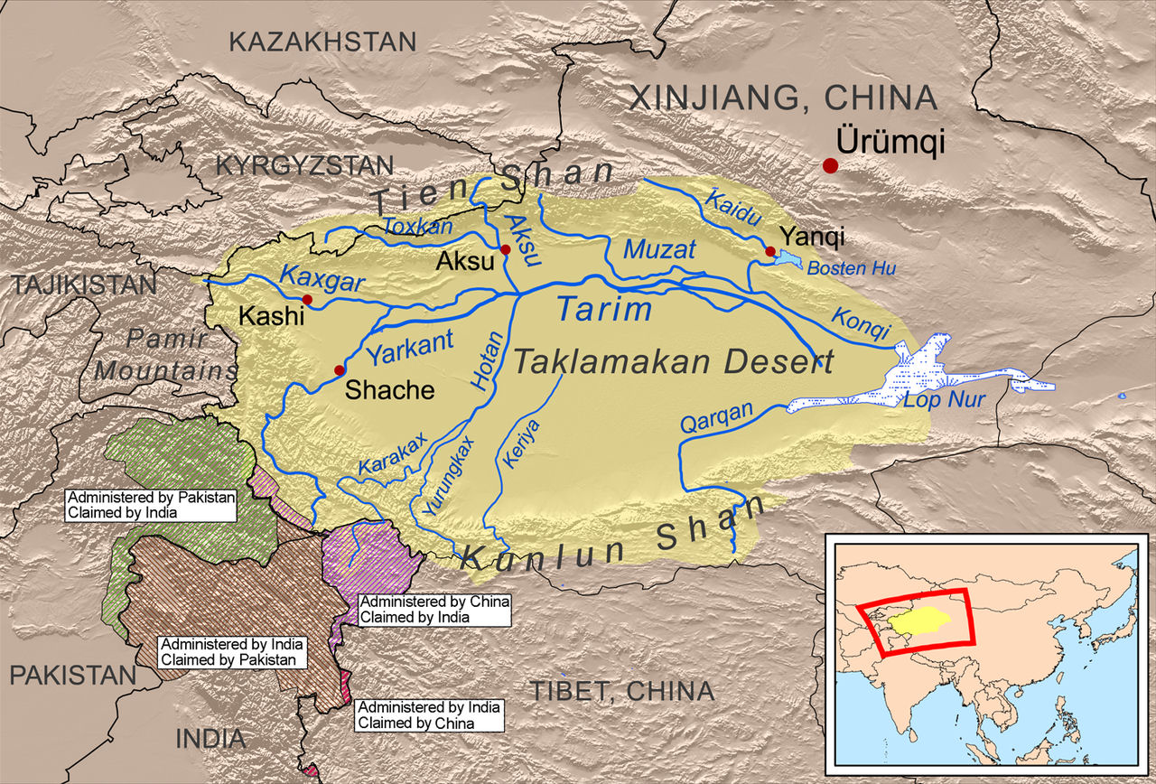 The Tarim Basin is the largest inland basin in China, located between the Tianshan Mountains and the Kunlun Mountains. The widest point from north to south is 520 kilometers, and the longest point from east to west is 1,400 kilometers. The area is about 400,000 square kilometers.
The Tarim Basin is a large enclosed intermountain basin. The geological structure is a stable block bounded by many deep and large faults. The basement of the block is ancient crystalline rock. There are Paleozoic and Proterozoic sedimentary layers about one thousand meters thick on the basement, and there are thin Mesozoic and Cenozoic sedimentary layers. The area of Quaternary sediments is very large. The topography of the basin is high in the west and low in the east, slightly inclined to the north. The elevation of the old Lop Nur lake is 780 meters, which is the lowest point of the basin. The Tarim River is located on the northern edge of the basin, and the water flows eastward.
The landform of the basin is distributed in a ring shape, with gravel Gobi connected to the mountains at the edge, a vast desert in the center, and alluvial fans and alluvial plains between the edges and the desert, and there are oasis distribution. To the south of the Tarim River is the Taklimakan Desert, covering an area of 337,000 square kilometers, accounting for 20% of Xinjiangs area and 26% of the total area of Chinas deserts and Gobi (for example, the desert alone accounts for 43%). It is the largest desert in China and also in the world. The No. 2 mobile desert. Individual sand dunes move about 50 to 60 meters south every year, and the area of mobile sand dunes accounts for 85%. The sand dunes have complex shapes, such as pyramids, domes, fish scales, compound dune chains, compound sand ridges, and so on.
The Tarim Basin has a warm temperate climate, with a total annual solar radiation of 575 to 627 kilojoules per square centimeter. The annual sunshine hours are about 3,000 hours in the north and less than 3,000 hours in the south. There is a lot of windy sand and floating dust. The annual average temperature is 9-11°C, slightly higher in the south than in the north. The continental nature is strengthened from west to east. In winter, the east is colder than the west. The average temperature in January is 3.2°C lower than that of Hotan and 2.4°C lower than that of Kashgar. The freezing days in winter when the average temperature is lower than -20°C are only 1 to 2 days. The average temperature in July is 25~27°C. The active accumulated temperature above 10°C exceeds 4000°C, and the southern part is higher than the northern part; its duration is 200 days in the south and more than 190 days in the north; the accumulated temperature varies greatly from year to year. The frost-free period is more than 200 days, 200 to 210 days in the north, and 220 days in the south. The annual average daily temperature range is 14-16°C, and the maximum daily range is 25°C.
Natural disasters are mainly sandstorms and dry hot winds. For strong winds above level 8 (wind speeds greater than 17 m/s), only Ruoqiang, Kashgar and Korla have more than 20 days a year. However, the vegetation coverage at the edge of the basin is only 10%, and there is basically no vegetation in the center of the desert, and the wind speed is 5 meters per second, so sandstorms in the south can reach 30-40 days a year. The northeast wind and northwest wind are dominant, and the sand dunes at the edge of the basin are moving to the south. The severely damaged area is the eastern part of the basin, with 10 to 20 days a year; other areas of the basin occur less frequently.
The water in the basin mainly comes from westerly air currents, passing from Central Asia to the southern valley of the Tianshan Mountains (such as the Kezi River Valley) or from the Junggar Basin across the Tianshan Pass (such as Hami, Urumqi) into the basin. The basin has sparse precipitation, 85 mm in Wushi and 57 mm in Aksu on the western edge of the basin; 63 mm in Kuqa on the northern edge and 52 mm in Korla on the northern edge; 78 mm in Atushi, 65 mm in Kashgar and 35 mm in Hotan on the southern edge, from west to east. If the Qiang is 17 mm, the basin itself cannot form runoff, but the annual precipitation in the surrounding mountainous areas reaches 200-400 mm, which can merge into a river to reach the basin. The larger rivers include the Yerqiang, Kizil, Gaizi, Hotan, Keliya, Cheerchen (Qiemo) rivers in the south, and Aksu, Tailan, Weigan, Kuqa and Kaidu (downstream) rivers in the north.
In the natural state, the above-mentioned rivers can flow into the Tarim River; in the case of a large amount of water diversion for irrigation, the only existing water that flows into the Tarim River is Aksu, Hotan, and Yerqiang. The annual runoff flowing from the surrounding mountainous areas to the basin is about 37 billion cubic meters. The area east of longitude 84° accounts for 45%, and the annual runoff is 18%. Together with the 3.2 billion cubic meters of water transported to the east by the Tarim River, it accounts for 26%. %; The western area accounts for 55%, and the annual runoff is 82%, minus the eastward transportation part, which actually accounts for 74%.
Lop Nur in the eastern part of the basin is the terminus of the Tarim River. It used to be called a wandering lake, but in fact the lake itself does not wander. The replenishment of groundwater in the basin mainly comes from riverbeds, channels and field seepage. The dynamic reserves of groundwater are 11 to 14.8 billion cubic meters; after improving the level of irrigation management, there are still more than 7 billion cubic meters of dynamic reserves. The rational use of groundwater has certain significance in solving the water shortage in the basin in spring and protecting the ecological environment. In addition, there are a considerable amount of groundwater static reserves in the basin, especially in the depression zone with deep Cenozoic sedimentation, such as the Kuqa depression and the Kashi-Yerqiang depression. To understand the quantity and quality of water resources, and to extract them in an appropriate amount, is also meaningful to increase water resources.
The basin is mainly composed of brown desert soil, cracked soil and residual saline soil along the southern foot of Tianshan Mountain and northern foot of Kunlun Mountain. Kunlun Mountain and the northern foot of Altun Mountain are mainly composed of brown desert soil with gypsum salt pan. On the alluvial plains along the lower reaches of the Tarim River and the Dahe River, there are mainly meadow soil and Populus euphratica forest soil (also known as Tukhayi soil in soil science). The meadow soil is widely distributed, with the most concentrated on both sides of the river channel from Luntai to Yuli. Populus euphratica forest soil develops under the dense and shady Populus euphratica forest, which is characterized by high organic matter content (1% to 2% or more) and low salt content. Meadow soil and Populus euphratica forest soil are the main objects of agricultural reclamation. This causes forest destruction, which is detrimental to environmental protection and deserves attention.
The oil and natural gas reserves in the Tarim Basin are very rich, accounting for about 1/6 and 1/4 of the national oil and gas reserves, respectively.
|
NEWSLETTER
|
| Join the GlobalSecurity.org mailing list |
|
|
|