

Drillships - Scientific
The planet Earth is made up of three main shells: the very thin, brittle crust, the mantle, and the core; the mantle and core are each divided into two parts. Although the core and mantle are about equal in thickness, the core actually forms only 15 percent of the Earth's volume, whereas the mantle occupies 84 percent. The crust makes up the remaining 1 percent.
The boundary between the crust and mantle is called the Mohorovicic discontinuity (or Moho); it is named in honor of the man who discovered it, the Croatian scientist Andrija Mohorovicic. No one has ever seen this boundary, but it can be detected by a sharp increase downward in the speed of earthquake waves there. The explanation for the increase at the Moho is presumed to be a change in rock types. Drill holes to penetrate the Moho have been proposed, but drilling expense increases enormously with depth, and Moho penetration is not likely very soon.
On Russia's Kola Peninsula, near the Norwegian border at about the same latitude as Prudhoe Bay, the Soviets have been drilling a well since 1970. By 1985 it was over 40,000 feet (12 km) deep, making it the deepest hole on earth (the previous record holder was the Bertha Rogers well in Oklahoma--a gas well stopped at 32,000 feet (9750 m) when it struck molten sulfur). It is not oil or gas that is being sought with the Kola well, but an understanding of the nature of the earth's crust. By 1985 the Kola well had penetrated about halfway through the crust of the Baltic continental shield, exposing rocks 2.7 billion years old at the bottom (for comparison, the Vishnu schist at the bottom of the Grand Canyon dates to about 2 billion years--the earth itself is about 4.6 billion years old). In order to get their single drill hole down as far as they did, the Soviets had to resort to experimental methods.
Over the continental areas of the world the earth's crust is about 20 miles (32 km) thick, but it is only about one-fifth that in the oceanic areas. In both cases, the crust overlies a mantle which can be detected because it transmits seismic waves at a distinctly higher velocity than does the crust, although there are also velocity variations within the crust itself. The oceanic Mohorovic discontinuity (Moho), which marks the boundary between the crust and upper mantle is typically observed as a strong reflector with a sharp velocity gradient on these profiles.
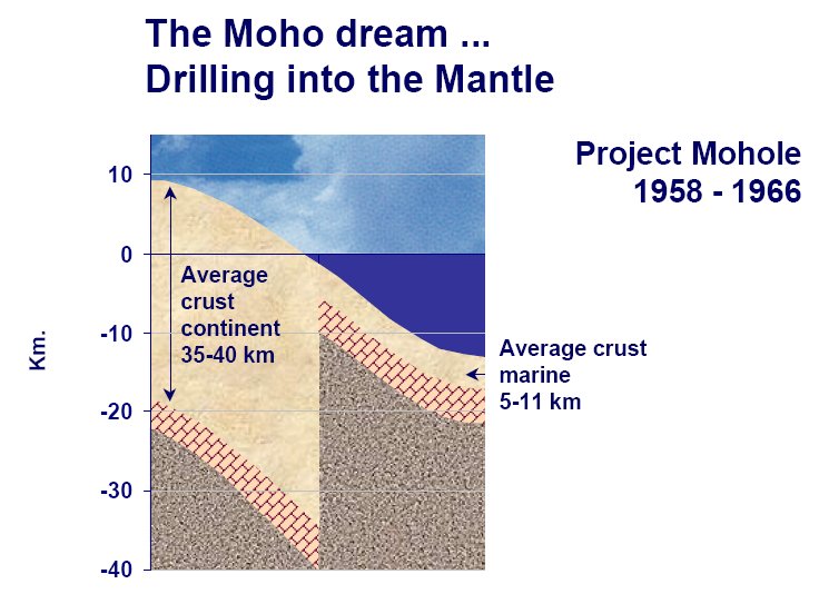 In 1957, two well-known oceanographers -- Walter Munk of the Scripps Institution of Oceanography in California and Harry Hess of Princeton University -- proposed developing a capability to drill deeply into the Earth beneath the seafloor, allowing oceanographers to sample the material below the boundary of Earth's crust and mantle, the Moho. Their efforts eventually led to Project Mohole, an attempt to acquire a ship that would let researchers drill into the Moho. Cost escalations eventually killed the project. Project Mohole was abandoned in 1966 because of lack of funding, without ever taking a sample of the Moho. Drilling in deep water presents some very interesting engineering problems that are really expensive to circumvent. The project was dropped in favor of the GloMar Challenger drilling project.
The Mohole project to drill through the earth's crust provides a classic example of the difficulties encountered in seeking support of large-scale, expensive scientific undertakings. The initial objective was to drill through the ocean crust into the underlying mantle rocks. The project proved to be so technically challenging and so mired in management missteps that after many years and many wasted millions of dollars it took an act of Congress to kill it. The demise of Mohole, a grandiose, costly and ill-conceived project to drill deep into the earth, proves that bad ideas are not inevitably implemented. The plan to drill a hole through the sea floor to the juncture with the mantle, or "Mohorovic discontinuity," was so problematic that by the time Congress cancelled the program in 1967, critics had dubbed it "project no hole."
The remnants of Project Mohole became the four-institution-member Joint Oceanographic Institutions for Deep Earth Sampling (JOIDES), forerunner of present-day JOI. Out of the ashes of the Mohole Project arose the Deep Sea Drilling Project, now known as the Integrated Ocean Drilling Program. The Mohole's successor program had much more modest and achievable goals that kept the scientific community excited and engaged as remarkable discoveries were made in every ocean basin.
The Joint Oceanographic Institutions for Deep Earth Sampling (JOIDES) secured long-term funding from the National Science Foundation and leased a custom drillship from Global Marine Development Inc. named GLOMAR Challenger. On June 24, 1966 the Prime Contract between the National Science Foundation and The Regents, University of California was signed. This contract began Phase I of the Deep Sea Drilling Project (DSDP), which was based out of Scripps Institution of Oceanography at the University of California, San Diego. Global Marine, Inc. performed the actual drilling and coring. The Levingston Shipbuilding Company laid the keel of the D/V Glomar Challenger on October 18, 1967, in Orange, Texas. The ship was launched on March 23, 1967, from that city. It sailed down the Sabine River to the Gulf of Mexico, and after a period of testing, the Deep Sea Drilling Project accepted the ship on August 11, 1968. Over the next 30 months, Phase II consisted of drilling and coring in the Atlantic, Pacific, and Indian oceans as well as the Mediterranean and Red Seas. Technical and scientific reports followed during a ten month period. Phase II ended on August 11, 1972, and ship began a successful scientific and engineering career.
Although itself a remarkable engineering feat, the Challenger was the site of many advances in deep ocean drilling. One problem solved was the replacement of worn drill bits. A length of pipe suspended from the ship down to the bottom of the sea might have been as long as 20,483 ft (6243 m)(as was done on Leg 23 Site 222). The maximum depth penetrated through the ocean bottom could have been as great as 4,262 ft (1299 m)(as at Site 222). To replace the bit, the drill string must be raised, a new bit attached, and the string remade down to the bottom. However, the crew must thread this string back into the same drill hole. The technique for this formidable task was accomplished on June 14, 1970, in the Atlantic Ocean in 10,000 ft (3048 m) of water off the coast of New York. This re-entry was accomplished with the use of sonar scanning equipment and a re-entry cone which had a diameter of 16 ft (4.88 m) and height of 14 ft (4.27 m).
The Glomar Challenger tied dock for the last time with the Deep Sea Drilling Project in November 1983. Parts of the ship, such as its dynamic positioning system, engine telegraph, and thruster console, are stored at the Smithsonian Institution.
The Integrated Ocean Drilling Program (IODP) is an international research program that explores the history and structure of the earth as recorded in seafloor sediments and rocks. IODP builds upon the earlier successes of the Deep Sea Drilling Project (DSDP) and the Ocean Drilling Program (ODP), which revolutionized our view of Earth history and global processes through ocean basin exploration. IODP represents the latest generation of these highly successful scientific ocean-drilling initiatives and seeks to greatly expand the reach of these previous programs by forming a collaborative union between the United States, Japan, and the European Union.
The scientific research vessel JOIDES Resolution began operations in 1978 as the Sedco/BP 471, originally an oil exploration vessel. In January 1985, after being converted for scientific research, the vessel began working for the Ocean Drilling Program (ODP). Drilling with ODP continued until September 2003, at which point the Integrated Ocean Drilling Program (IODP) began. IODP is a multi-drilling platform research program. JOIDES Resolution will continue to serve as IODP's riserless vessel, along with the riser vessel Chikyu operated by Japan, and mission-specific platforms operated by the European consortium ECORD. The JOIDES Resolution is owned by Overseas Drilling Limited, which is a joint venture company owned 50% by Transocean and 50% by DSND Shipping AS.
The vessel is named for the HMS Resolution, which explored the Pacific Ocean, its islands, and the Antarctic region under the command of Captain James Cook over 200 years ago. Like its namesake, the purpose of the current Resolution is to sail for scientific exploration. But this time, those discoveries lie deep beneath the oceans.
The physical dimensions of the ship are remarkable. Fitted with a derrick standing 61.5 m (202 ft) above the water line, the 143 m (469 ft) long ship is 21 m (68.9 ft) wide. During a leg, the crew positions the ship over the drill site using 12 computer-controlled thrusters as well as the main propulsion system. The rig can suspend as much as 9,150 m (30,020 ft) of drill pipe to an ocean depth as great as 8,235 m (27,018 ft).
Near the center of the ship is the "moon pool," which is a 7 m (23 ft) wide hole, through which the drill string is lowered. Each pipe joint is about 28.5 m (93.5 ft) and weighs about 874 kg (1925 lb). The drill crew uses the draw works to thread each joint to the drill string. The process of lowering the drill bit, which is affixed to the end of the drill string, takes about 12 hours in 5,500 m (18,045 ft) of water (Lowering the Drill String; 1-Mb mpeg illustration). To core through the seafloor, the entire drill string is rotated. The thrusters mounted underneath and facing perpendicular to the long axis of the ship keep the massive vessel from rotating.
The National Science Foundation's (NSF) investments in state-of-the art tools for research and education are intended to enable discovery at the frontiers of science and engineering and concurrently enhance the productivity, effectiveness, and continual renewal of the science and engineering workforce. A subset of the NSF investment in tools is funded through the Major Research Equipment and Facilities Construction (MREFC) Account.
The Scientific Ocean Drilling Vessel (SODV), which is funded by the NSF through funds in MREFC, will serve as the state-of-the-art, riserless drilling research platform for the science community as well as the United States' contribution to support the scientific mission of the Integrated Ocean Drilling Program (IODP), an international program of basic research in the marine geosciences, supported by NSF and numerous international partners. IODP will build upon the successes of Ocean Drilling Program (ODP) by enhancing the capabilities of scientific ocean drilling through international partnerships using multiple drilling platforms.
On May 23, 2006 the United States Implementing Organization (USIO) announced the initiation of a multiyear subcontract with Schlumberger Technology Corporation to provide personnel, infrastructure and downhole equipment for the Integrated Ocean Drilling Program's Riserless Vessel. Schlumberger will provide logging systems design services to the USIO during the first and second year of the contract as the program's riserless vessel undergoes a major conversion to be completed in 2007. At the completion of the conversion effort, global science operations with the converted vessel will continue at least through 2013.
SODV will not be the same as its predecessor, the JOIDES Resolution. First, the ship will be lengthened by 32 feet in order to provide increased laboratory space, update the accommodations, and improve the stability of the vessel. To accomplish this, the ship will be cut in half, the ship laboratory "stack" section removed and replaced with a longer section. Spaces forward of the old laboratory "stack" will be completely gutted, rearranged, and newly outfitted. The entire ship forward of the drill rig will be essentially new. New science equipment is being purchased and existing equipment refurbished so as to meet the IODP minimum and standard scientific measurement capabilities. The drill rig equipment and instrumentation will be refurbished or replaced as needed. Other portions of the vessel will be repaired and equipment refurbished to provide the service life that is envisioned for SODV, which the "JR" could not provide in its present condition.
A dedicated European research icebreaker was proposed in 2001 by The European Polar Board under the project name Aurora Borealis. This would be a novel ship for dual use, able to visit the Arctic in all seasons. A removable drill rig would allow summer drilling operations. Container laboratories would maximise space/versatility. It would be a powerful ship similar in size and power to the Russian nuclear icebreakers approx 30,000 m tonnes and be able to keep station in the drifting ice pack. Riserless deep drilling in a principle moon pool is envisaged. It will also be able to deploy AUVs and ROVs through a smaller secondary moon-pool. The Novel propulsion system, power supply and icebreaking capability in drifting pack would make this vessel unique in the world.
In May 2006 the German Science Council recommended going ahead with construction of the new research vessel Aurora Borealis. The research icebreaker, designed as a European cooperative project, will not only be equipped with state-of-the-art technology, but will also have a drilling platform. The ship is designed primarily for operation in the Arctic and will be the first of its kind capable of working in the Central Arctic Ocean during winter.
|
NEWSLETTER
|
| Join the GlobalSecurity.org mailing list |
|
|
|