

| THIS CHAPTER IMPLEMENTS STANAG 3570. |
A drop zone is any designated
area where personnel and or equipment may be delivered by parachute
or, in the case of certain items, by free drop. The DZ is located
where it can best support the ground tactical plan. It is selected
by the ground unit commander, usually on the technical advice
of the DZST leader. For tactical training the USAF assault zones
availability report should be checked for an approved DZ within
the tactical area. If the selected DZ is not on the AZAR, a tactical assessment
must be conducted.
The drop zone selection factors
discussed in this section are used to analyze the suitability
of a drop zone.
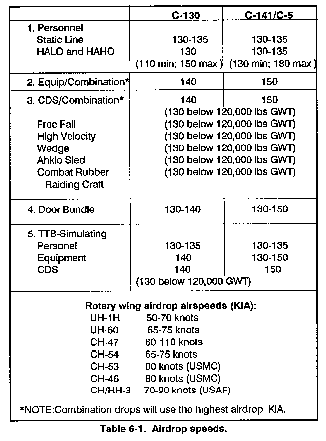
The aircraft airspeed will
determine the time over the drop zone. Table 6-1 provides the
USAF airdrop and rotary-wing airdrop speeds in knots indicated
airspeed. (Table 6-1 Airdrop speeds.)
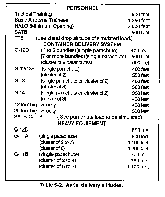
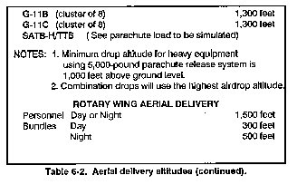
Drop altitude is measured
from above ground level, which is from the highest field elevation
on the drop zone to the drop aircraft. However, some drop aircraft
may request the drop altitude in feet indicated, which is measured
on the aircraft altimeter from sea level. To calculate feet indicated,
take the field elevation and round it up to the nearest 50 feet
(537 feet becomes 550 feet), then add the drop altitude in feet
AGL For example, if the drop altitude is 800 feet AGL and the
field elevation is 550 feet, then the drop altitude is 1,350 feet
indicated. See Table 6-2 for the drop altitude for different type
training missions. In combat (wartime) operations, the drop altitudes
are determined jointly by airborne and airlift commanders.
6-3. DROP ZONE TIME REQUIREMENT
ESTIMATION
For personnel, allow 1 second
for each jumper to exit the aircraft; do not count the first jumper
in the door. For example, 10 jumpers (minus 1) require 9 seconds.
For equipment, allow 3 seconds per door bundle to exit; do not
count the first bundle in the door. For example, 2 bundles (minus
1) requires 3 seconds.
When considering the method
of delivery, take care when using high velocity airdrops or free
drops around built-up areas or airfields because of the risk of
damage to buildings or airstrips.
a. A low velocity airdrop
is used for sensitive equipment and personnel. The parachute slows
the rate of the descent for a soft landing.
b. A high velocity airdrop
is the delivery of certain items of supply rigged in airdrop containers
with an energy dissipater attached to the underside of the load
and a ring slot parachute attached to the top of the load. The
chute is designed to stabilize the load and reduce the rate of
fall to ensure an acceptable landing shock.
c. A free drop is used for
nonsensitive items only. No parachute is attached to stabilize
or slow the rate of descent of the cargo.
NOTE: When determining
the suitability of the DZ and considering the method of delivery
around built-up areas or airfields, you must consider the additional
risk of damage to buildings when using high-velocity or free-drop
methods.
To ensure that the airdrop
is safe, and that personnel and equipment can be recovered and
employed to accomplish the mission, the DZ and adjacent areas
should be free of obstacles.
a. Obstacles to personnel
are any features, either natural or man-made, that would pose
a hazard to a parachutist.
b. Obstacles to equipment
are any features, either natural or man-made, that may hinder
the recovery of equipment. Examples of such obstacles are:
-
(1) Trees 35 feet or higher,
which would impede recovery of personnel or equipment.
(2) Water more that 4 feet
deep within 1,000 meters of any edge of the drop zone.
(3) Any other conditions that
may injure parachutists or damage equipment, such as barbed wire
fences, swamps, rocks, ditches, and gullies.
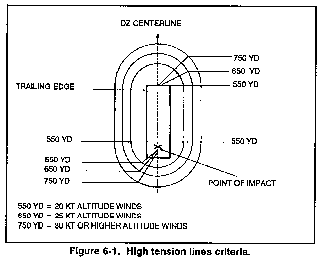
(4) Power lines that are carrying
active current of 50 volts or greater. Based on the reported altitude
wind, a safety zone is created in which power must be interrupted
to prevent accidental injury of a parachutist. Figure 6-1 shows
the size of the safety zone for various altitude wind velocities
during static line operations.
Avoid DZs with major obstacles
between the DZ and the objective area. Ensure that adequate routes
are available to conduct troop movement and equipment recovery.
The size of computed air release
point DZs during peacetime drop operations is determined by USAF
doctrine.
a. The CARP DZ for one jumper
will be a minimum of 549 meters (600 yards) by 549 meters (600
yards). Add 64 meters (75 yards) to the length of each additional
jumper.
b. The CARP DZs for the containerized
delivery system will be as indicated in Table 6-3.


c. The CARP DZs for heavy
equipment will be at least 549 meters(600 yards) wide and 915
meters (1,000 yards) long for one platform. If using a C-130,
add 366 meters(400 yards) to the length for each additional platform.
If using a C-141, add 458 meters (500 yards) to the length for
each additional platform.
d. If using more than one
aircraft not in trail formation, add 92 meters (100 yards) to
the width of all CARP DZs (46 meters/50 yards each side).
e. From official sunset to
sunrise, add 92 meters (100 yards) to the length and width of
all CARP DZs (46 meters/50 yards to each side and to each end).
NOTE: To convert yards to
meters, multiply yards by .9144; to convert meters to yards divide
meters by .9144.
f. To determine the required
size of Army VIRS DZs, use the D=RT formula, which is explained
in detail after paragraph g. A 100-meter buffer zone is required
at the leading and trail edge of the DZ when jumping personnel.
The buffer zones may be waived by the local commander if local
regulations permit.
g. For GMRS DZs, the minimum
size is 275 meters by 275 meters (300 yards by 300 yards). Additional
size requirements will redetermined using the D=RT formula. The
100-meter buffer (required for personnel drops only) at both the
leading and trail edge of the DZ will be included in the minimum
size.
D = ? (length of DZ needed
in meters)
R = Rate of the aircraft's
speed expressed in meters per second. To convert knots to meters
per second, multiply the knots by .51. Do not round this answer
off. See Table 6-1 for aircraft speeds.
T = Amount of time it takes
to exit each load. Parachutists require 1 second each. The first
parachutist is free (10 parachutists take 9 seconds). Door bundles
take 3 seconds each. The first bundle is free (3 bundle require
6 seconds).
EXAMPLE: How long must the
DZ be for a C-130 dropping 10 parachutists on a GMRS DZ?
D = ?
R = 66.3 meters per second
(130x.51).
T = 9 seconds (1 second per
parachutist not counting the first).
SOLUTION: D = R x T
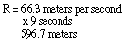
D = 597 meters of usable DZ
required. For personnel drop zones, add a 200-meter buffer (100
meters on the leading edge and 100 meters on the trail edge) to
total 797 meters for the drop zone. However, the commander can
waiver this requirement.
NOTE: Always round the answer
up to the nearest whole number.
g. To calculate the number
of parachutists or bundles that a GMRS DZ of given length can
accept in one pass, use the T = D/R formula. Type of aircraft
must be known.
T = ? (Amount of time that
the aircraft will be over the DZ in seconds.
D = Distance of DZ in meters
(length).
R = Rate of aircraft's speed
expressed in meters per second. To convert knots to meters per
second, multiply the knots by .51. Round this number up to the
nearest whole number.
EXAMPLE: How many parachutists from a C-130 can a 750-meter long DZ accept per pass? This is a GMRS DZ.
T =
D = 750 meters usable drop
zone.
R = 67 meters per second 130
x .51 = 66.3 rounded up to 67
SOLUTION: T = D/R
D/R = 11.3 (750/67)
T = 11 seconds (always round
down) DZ can accept 12 parachutists (11 parachutists at 1 per
second and 1 parachutist free) per pass.
h. To calculate the amount
of drift experienced by a load under a parachute use the D = K
x A x V formula.
D = ? The amount of drift
in meters.
K = Load drift constant = 3.0 personnel.
			= 1.5 door bundle
			= 1.5 heavy equipment
			= 1.5 containerized delivery system.
			= 2.4 tactical training bundle
A= Drop altitude expressed
in hundreds of feet (800 feet would be expressed as 8.
V = Velocity of the wind (either
surface wind or mean effective wind may be used). EXAMPLE: For
a drop altitude of 800 feet and wind speed of 11 knots, calculate
the amount of drift experienced by a jumper.
D = ?
K = 3.0 (parachutist)
A= 8 (800 feet)
V = 11 knots SOLUTION: D = K x A x V
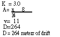
NOTE: Always round up to the
next whole number.
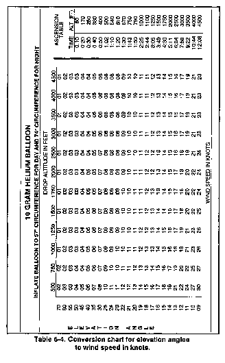
i. Measuring wind on the drop
zone entails surface wind and mean effective wind.
-
(1) Surface (ground) wind
should be measured by using the AN/PMQ-3A anemometer. This is
the only acceptable wind measuring device for personnel and heavy
equipment DZ operations.
-
10 grams for day: 57 inches
-
30 grams for day: 78 inches
-
10 grams for night: 74 inches
-
30 grams for night: 94 inches
(2) Mean effective wind is
the average wind from ground level to drop altitude. MEW is measured
by using the PILOT balloon. PIBAL circumferences areas follows:
At night a small liquid activated
light is attached to the balloon to assit in observation. For
PIBAL charts, refer to Table 6-4.

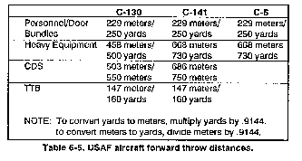
j. Forward throw is the effect
that inertia has on a falling object. When an object leaves an
aircraft, it is traveling at a speed equal to the speed of the
aircraft. The parachutist (or bundle) continues to move in the
direction of flight until the dynamics of gravity and the parachute
take effect. Forward throw for rotary-wing aircraft is half the
aircraft speed expressed in meters. To determine the amount of
forward throw when using a USAF aircraft, apply the following
distances:
6-8. APPROACH AND DEPARTURE
ROUTES
Routes for the aircraft into
and away from the DZs must be adequate. To ensure this, consider
the following factors:
-
Enemy situation and location.
-
Obstacles to the aircraft
(TV towers, high tension lines).
-
Terrain higher than the DZ.
-
No-fly areas.
The drop zone support team
will plan, establish, and operate day and night drop zones for
personnel/resupply missions flown by Air Force and Army aircraft.
The DZST is ultimately responsible for the accomplishment of the
mission on the DZ. In operations in which the USAF combat control
team is not present, the DZST has overall responsibility for the
conduct of operations on the DZ. It represents both the airborne
and airlift commanders. The DZST leader assumes all the responsibilities
normally associated with the USAF CCT and the DZSO.
The DZST will have at least
two members. More personnel maybe required depending on the complexity
of the mission; however, they may not have to be DZST qualified.
The senior member of the DZST will function as the drop zone support
team leader and he must bean NCO, sergeant or above officer; or
civilian equivalent. He must have completed the appropriate initial
training as a DZST member and satisfy current parent service requirements.
He must also be a qualified and current jumpmaster to conduct
personnel and heavy equipment drops. (See also paragraph 6-13.)
Primary missions of the DZST
include wartime CDS drops to battalion or smaller size units,
and peacetime visual meteorological conditions drops involving
one to three aircraft for personnel, CDS, and heavy equipment.
Secondary missions include wartime drops of brigade size or larger
units, peacetime drops of C-130 AWADS (all-weather aerial delivery
system) involving one to three aircraft, or VMC drops of four
or more aircraft.
6-11. EQUIPMENT FAMILIARIZATION
The DZST leader must have
a working knowledge of the equipment he will use during the establishment,
marking, and operation of his drop zone. The following basic equipment
is used by the DZST, however, there may be more or less equipment,
depending on the mission.
a. Anemometer. The
AN/PMQ 3A (NSN: 6660-00-515-4339) is a calibrated, hand-held wind
measuring device used for measuring surface wind. Oriented correctly,
it will give wind direction in degrees by pressing the trigger.
It is capable of reading the wind from 0 to 15 knots on the low
scale and from 0 to 60 knots on the high scale. The anemometer
must be calibrated every six months.
b. VS-17 Marker Panel Aerial.
The VS-17 marker panel (NSN: 8345-00-174-6865) is a two-sided
panel, 2 feet wide by 6 feet long. One side is fluorescent orange,
sometimes referred to as international orange, and the other side
is cerise, commonly referred to as red. It has six tie-down points
used to attach the panel to stakes. It also has three snap fasteners
on the short ends in the stow pocket. It should be folded up so
that the olive drab green is showing. The color of the panel used
should be the one that best contrasts with the surrounding area.
c. Light, Marker, Ground
Obstruction. This marker (NSN: 6230-00-115-9996) is also known
as the "beanbag light. " It is powered by one BA-200
battery, and its color can be changed by using interchangeable
colored plastic domes. The markers can be used in light holes
or on the surface and can be secured with tent pegs or by filling
the bottom with sand or rocks.
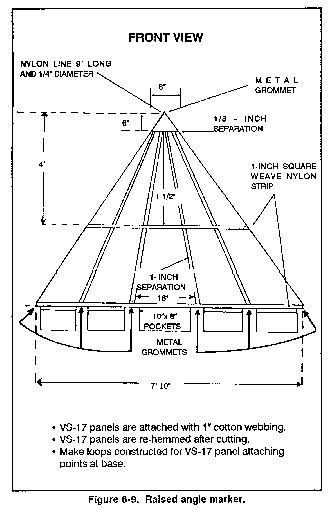
d. Raised Angle Marker.
The RAM is a locally constructed visual signal used to mark
the PI on CARP DZs. It is constructed by assembling five VS-17
panels as shown in Figure 6-8.
e. Whelen Light. This
light is powered by either the BA-4368 or the lithium battery
used in the PRC-77 radios. The light is placed on top of the battery
and is ready for operation. The color of the light can be changed
with different colored domes. It is a local purchase item.
f. M-2 Light Baton. The
M-2 (NSN: 6230-00-926-4331) is a flashlight powered by two BA-30s.
The color of the light can be changed with different lenses that
are stored in its base compartment. This light is used in light
holes or on top of the ground attached to a tent peg.
g. Aerial, Marker, Distress.
This marker (NSN 6230-00-67-5209) is an omnidirectional flashing
(strobe) light with a very long range. A directional cover can
snap on the top for tactical operations. Colors can be changed
with snap-on caps. The strobe light also has infrared capabilities.
h. Mirror, Emergency Signaling,
Type II. The signal mirror (NSN 6350-00-105-1252) can be used
to signal aircraft by reflected sunlight. There is a set of instructions
on the back of the signal mirror for proper use and aiming. The
signal mirror can still be used on hazy days. One misconception
is that it can only be used when facing the sun. It can be used
in all directions and can be seen as far as the horizon will go.
i. SE-11 Light Gun. This
light gun is a long-range, directional, visual-signaling device
used to signal aircraft to mark the release point on the drop
zone. It is powered by five BA-3030 batteries and can be set up
for remote operations. It has a red cap/lens, which is normally
used as a no-drop signal. The Air Force has a light, traffic air
B-2 (NSN 6210-00-578-67547) that is comparable to the SE-11 (NSN
5820-00-4074671).
j. Pilot Balloon. The
PIBAL is a 10- or 30-gram rubber balloon that when filled with
helium to the specified circumference is used to measure the mean
effective wind, which is the average wind from the ground to drop
altitude. The NSN for the Balloon Meteorological 10-Gram is 6660-00-663-7933.
The NSN for the Balloon Meteorological 30-Gram is 6660-00-663-8159.
k. Lighting Unit. This
light (NSN 6660-00-839-4927) is attached to the PIBAL for night
operations. The PIBAL is over-inflated to compensate for the weight
of the light so that the same ascension rate is achieved. The
PIBAL light has a wet-cell battery that is activated by water
or fluid. When temperatures fall below 50 degrees, the PIBAL light
activates faster by using warm water.
l. Drift Scale. This
slide-type scale uses a 90-degree angle to measure the ascent
of the PIBAL for determining the mean effective wind. It is locally
produced by TSC. (Also used for this purpose are the theodolite
(NSN 6675-00-861-7939) pocket transit with built-in clinometer
(NSN 6675-00-641-5735) or the clinometer (NSN 6675-01-313-9730).
m. AN/PRC-l19A Radio or
SINCGARS. This man-portable radio NSN 5820-01-267-9482) is
used for contacting the aircraft with FM communication capabilities.
This radio can also be used for NAVAID with aircraft that have
FM homing capabilities. It has a range of 4 to 16 kilometers without
power increasing accessories.
n. PRC-113 Radio. This
is a man-portable UHF/VHF AM radio (NSN 5820-01-136-1519) that
has a quick, jam-resistant, ECCM transceiver. It is designed for
short range (5 to 16 miles), tactical, ground-to-ground, or ground-to-air
communication.
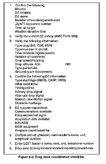
The drop zone coordination
checklist was designed so that the DZST leader could conduct a
pre-mission coordination without communicating with the aircraft
(Figure 6-2).
The following support requirements
apply to multiple aircraft formations (USAF aircraft), personnel,
and equipment; or to single aircraft operations on DZs more than
2,100 meters in length.
a. The DZST leader ensures
the DZ control group is in place on the DZ and operational one
hour before the drop. The composition of a complete control group
is as follows:
-
DZST leader.
-
Assistant DZST leader (must
be DZST qualified).
-
Malfunction officer or NCO
(with camera).
-
Parachute recovery detail
(with saw and tree climbing equipment).
-
Radios, one each for the DZST
leader and the assistant leader (minimum).
-
Anemometers, AN/PMQ-3A one
each for the DZST leader and the assistant DZST leader.
-
Smoke grenades/flares (as
required).
-
Vehicles (as required).
-
Road guards (as required).
-
Military police (if required
to control vehicles and spectators)
-
* Two medical personnel with
front line ambulance.
-
* Boat detail (if required).
If water more that 4-feet deep is within 1,000 meters of any edge
of the drop zone, at least one boat with operator and assistant
operator is required. The boat must be in the water with the engine
running, and there must be a life jacket on board for every parachutist
on the first pass. For deliberate water jumps, each parachutist
will wear a life vest.
c. If there are single aircraft
(no more than 20 seconds exit time or 2,100 meters or less of
usable DZ), a partial control group with at least the following
personnel and equipment can handle the DZ.
-
DZST leader.
-
Assistant DZST leader (not
necessarily DZSTL qualified).
-
Anemometers, AN/PMQ-3A.
-
* One medic (with FLA).
-
Malfunction officer or NCO
(with camera).
-
Parachute recovery detail.
-
Radio.
-
Anemometer, AN/PMQ-3A.
-
Compass.
-
Smoke grenades/flares (as
required).
-
VS-17 panels.
-
Smoke grenades/flares.
-
White lights (Whelen or M-2
light baton).
-
Air traffic control light
(SE-11 or B-2).
-
Signal mirror.
-
Strobe light.
-
Binoculars.
-
Anemometer, AN/PMQ-3A (required
for personnel and heavy equipment drops, recommended measuring
for all types of drop).
-
Compass.
-
PIBAL kit with helium.
-
Night vision goggles (for
night drops).
6-14. DROP ZONE SUPPORT
TEAM LEADER'S DUTIES
The DZST leader is responsible
for the overall establishment and operation of the DZ He selects
the locations of the control center, point of impact, and release
point. He is ultimately responsible for the accomplishment of
the mission. Specifically, the leader ensures he
a. Has the drop zone fully
operational one hour before drop time and conducts pre-mission
coordination.
b. Opens the drop zone through
range control and closes it when accountability of personnel,
air items, and equipment is completed.
c. Conducts ground or aerial
reconnaissance of the drop zone for obstacles or safety hazards
at least one hour before the drop.
d. Establishes communication
with departure airfield control officer no later than one hour
before drop time.
NOTE: The DZST leader may
perform this additional duty provided he has received specialized
Chapter 17, FM 57-230.
e. Controls all ground and
air medical evacuations. (Refer to paragraph 6-26 for MEDEVAC
format.)
f. Submits post mission reports
to appropriate agency.
g. Operates all visual acquisition
aids.
h. Ensures no-drop signals
are relayed to the drop aircraft.
i. Ensures all DZ markings
are correctly displayed.
j. Establishes a 10-minute
window. A continuous monitoring of the surface winds must commence
no later than 12 minutes before TOT. For example, if the TOT is
0700 hours, then the window begins at 0648 hours (two minutes
are added to allow adequate time to relay a no-drop signal if
needed). If at any time during the 10-minute window the winds
exceed allowable limits, the DZST leader will relay a no-drop
to the aircraft. Once a no-drop has been called, a new 10-minute
window is established. So, if the winds pick up at 0655 hours,
a no-drop is called and a new window runs from 0655 to the new
TOT of 0705 hours.
k. Takes surface wind readings
from the control center location and from the highest point of
elevation on the DZ when the DZ exceeds 2,100 meters in length
or when it is a multiple aircraft operation.
l. Calls a no-drop when surface
winds exceed the following limits:
| TYPE OF LOAD | SURFACE WIND KNOTS |
| Personnel (land) | 13 |
| Personnel (water) | 17 |
| HALO/HAHO | 17 |
| Equipment without ground disconnects | 13 |
| Equipment with ground disconnects | 17 |
| CDS/door bundles using G-13/14 type parachutes | 20 |
| USAF tactical training bundles | 25 |
| High-velocity CDS | No Restrictions |
The control center is where
the DZST leader controls and observes the airborne operation.
This is one of the locations where wind readings are taken. The
DZST leader should have all radios, signaling devices, and appropriate
forms positioned at the control center. The location of the control
center will be determined by the type of mission.
a. For personnel drops, the
control center will be located at the PI.
b. For CDS drops, the control
center is located 150 yards to the 6 o'clock of the PI.
c. For free drops, heavy equipment,
and AWADS with a ceiling of less than 600 feet, the control center
will be located off the drop zone. However, it should be located
so that the approaching aircraft can be observed along with the
PI. For example, the leading edge may be a poor location due to
obstruction by the woodline.
d. For all GMRS and VIRS DZs,
the control center will be located at the release point.
When voice control of aircraft
becomes limited, visual communication becomes a very important
way to relay information to the aircraft. No-drop and mission
cancellation situations are two of the most important of these
visual signals.
a. To identify a no-drop situation
to the aircraft, scramble the shape designator and remove the
markings or any other pre-coordinated signal on the DZ.
-
(1) The drop aircraft should
continue to do racetracks until a signal for clearance to drop
is given. A no-drop maybe given when winds exceed the maximum
limitations for that type of drop, when there are vehicles moving
on the drop zone, or when any other unsafe act is observed on
the drop zone.
(2) In pre-mission coordination,
it should be determined how many no-drop passes the aircraft will
fly until the mission is cancelled and they begin their return
to base.
c. At night, your clear-to-drop
signals could include shape designator illumination, a flashing
white light, a green light, or any other device available that
was coordinated in advance.
6-17. DETERMINATION OF
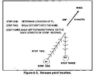
RELEASE POINT LOCATION
Procedures for determining
a release point on a GMRS drop zone, Air Force VIRS drop zone,
or Army rotary wing VIRS drop zone areas follows:
STEP 1. Determine the location
of the point of impact which is where the first parachutist or
load will land. The following criteria should apply. For door
bundles the PI maybe located at the leading edge of the tree line,
centerline. For personnel, the PI should be on the leading edge
of the 100-meter buffer zone, centerline. For CDS and heavy equipment,
refer to MAC Form 339 for the surveyed PI location. For CDS and
heavy equipment on nonsurveyed DZs, refer to the standard PI locations
for tactical assessments.
STEP 2. Determine the drift
direction and distance. Computes D = KAV formula for your mission.
Determine back azimuth of wind direction. From the PI location
pace off the distance computed from D = KAV formula into the wind.
If the wind is blowing to an azimuth of 200 degrees, then the
pace-off azimuth is 020 degrees.
STEP 3. Determine the forward
throw. Once you have paced off the drift, walk off the forward
throw. To do this, shoot a back azimuth of drop heading and walk
the distance of the forward throw (for Air Force aircraft forward
throw, refer to Table 6-5. For rotary wing aircraft, divide the
drop airspeed in half, and express in meters. For example, the
drop speed of 90 knots equals 45 meters of forward throw. The
release point is at the end of the forward throw (Figure 6-3).
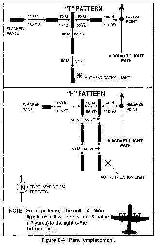
6-18. GROUND MARKING RELEASE
SYSTEM
The GMRS is a means for the
DZST to identify the release point to the drop aircraft. The pilot
uses the markings to adjust his flight path 100 meters to the
right of the comer panel/light and parallel to the approach-comer
panel/light axis. (Wherever panel is used in the following subparagraphs,
light may be substituted.) This method was designed for use without
radio communication between the drop zone and the aircraft.
a. The DZ will be marked with
an inverted "L," "H," or "T" pattern
using VS-17 panels. The inverted L consists of 4 panels; the approach
panel, the comer panel, the alignment panel, and the flanker panel.
The comer panel is located 100 meters to the left (as seen from
drop heading) of the release point. (Refer to Figure 6-4, for
panel emplacement). All other panels are aligned with and oriented
to the comer panel. For establishment of the seven panel "H"
and six panel "T" pattern, which are recommended for
C-141/C-5 airdrops due to the aircraft side-angle-vision limitations
pattern, refer to Figure 6-4.
b. The alignment panel is
50 meters to the left of the corner panel. The approach panel
is 50 meters in front of the corner panel as seen from drop heading.
The flanker panel is 150 meters to the left of the alignment panel
as seen from drop heading.
c. The DZST places the markings
where obstacles will not mask the pilot's line of sight. As a
guide, he uses a mask clearance ratio of 1 to 15 units of horizontal
clearance (Figure 6-5).
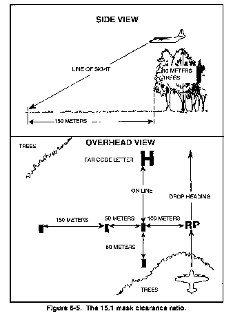
-
(1) For example, if you must
position a drop zone marker near a terrain mask such as the edge
of a forest that is on the drop zone approach, and the trees are
10 meters (33 feet) high, the markings would require 150 meters
(492 feet) of horizontal clearance from the trees (Figure 6-6).
(2) If any of the GMRS markings
fall within a 15:1 mask clearance ratio on the approach end of
the drop zone, an Army code letter (H, E,A, T), or a far (marker)
panel may be placed on the trailing edge of a drop zone if coordinated
for during the DZST/aircrew mission briefing. If a code letter
is used, it can be used to distinguish the drop zone from other
drop zones in the area.
e. The release point should
be marked with some type of identifiable light source distinct
from all other DZ markings.
6-19. ARMY VERBAL INITIATED
RELEASE SYSTEM
Army VIRS is a method of establishing
the release point on the DZ by using radio communications. A code
letter may mark the RP if this is tactically feasible, but the
aircraft initiates the drop on verbal command from the ground.
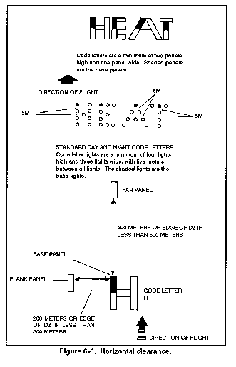
a. A standard Army code letter
using VS-17 panels for daytime operations will be emplaced at
the release point. The base panel of this code letter will be
positioned exactly on the RP. The code letter will be either H,
E, A, or T and will be at least two panels high and one panel
wide (Figure 6-6).
b. A flank panel is emplaced
to the left of a code letter at a distance of 200 meters or the
edge of the DZ, whichever is less. A far panel is emplaced 500
meters from the code letter along drop heading or at the end of
the DZ, whichever is less. Both far and flank panels are positioned
with the long axis parallel to drop heading and raised at 45 degrees
back toward the code letter. The GTA radio operator will be positioned
at the release point.
c. At night the panels in
the code letter are replaced with lights. The code letter will
be at least four lights high and three lights wide with 5 meters
between each light. The code letter and far light will be placed
in directional holes and the flank light will be in a bidirectional
hole.
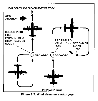
d. In case the release point
(RP) falls off the DZ making the markings not visible, or the
GTA operator cannot see the aircraft, the parachute drop can be
changed to a jumpmaster-directed release operation using the wind
streamer vector count (Figure 6-7).
e. In situations where the
RP falls off the DZ and the jumpmaster is unable to conduct a
wind streamer vector count, a delayed release or an early release
maybe conducted. For example, a late release is done by determining
how many seconds the aircraft must fly past the GTA operator before
the release is initiated. An example with the drop speed of 70
knots is 70 x .51 = 36 meters per second of flight.
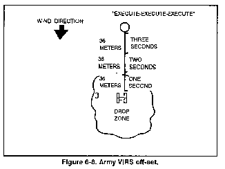
f. On an Army VIRS DZ where
the RP is in the woodline, an off-set may be used (Figure 6-8).
For example, a UH- lH is traveling 70 knots. Converted to meters
per second, this is about 36 meters per second. If the RP is 108
meters into the woodline, the GTA operator will allow the aircraft
to pass the code letter. As the aircraft passes over the code
letter, the GTA operator will begin counting "one thousand,
two thousand, three thousand." At the end of three seconds,
the GTA operator will transmit, "Execute, execute, execute."
6-20. AIR FORCE VERBAL
INITIATED RELEASE SYSTEM
The USAF VIRS drop zone does
not require markings. This specialized procedure is normally used
when regular markings are not tactically feasible or would not
be visible from the air. However, before considering a USAF VIRS
DZ, you must have radio communications with the drop aircraft,
and at least two FM/VHF/UHF radios should be on the DZ.
a. To establish a USAF VIRS
drop zone, a release point is determined the same way as a GMRS
or rotary-wing VIRS release point. (Refer to paragraph 6-17 and
Figure 6-2 to determine release point location.)
b. At the release point location,
the DZST leader will verbally guide the pilot over the release
point to align the aircraft so the drop can be initiated.
c. Instructions transmitted
to the aircraft must be concise: Left and right turns will be
given to align aircraft on desired inbound heading. Stop turn
is given when aircraft is on course. Standby is given about 5
seconds prior to release or as pre-briefed, and execute will be
given three times when the aircraft reaches the predetermined
release point. An example of a USAF VIRS Transmission is as follows:
AIRCRAFT: T2S26, THIS IS HERC
30, OVER.
DZST: HERC 30, THIS IS T2S26,
AUTHENTICATE DELTA FOXTROT, OVER.
AIRCRAFT: T2S26, THIS IS HERC
30, GOLF, OVER.
DZST: HERC 30, T2S26 - NOT
IN SIGHT, CONTINUE OVER.
-- ONCE THE AIRCRAFT IS ABOUT
ONE MINUTE OUT --
DZST: HERC 30, THIS IS T2S26,
HAVE YOU IN SIGHT, TURN LEFT.
DZST: (ELIMINATE CALL SIGNS)
TURN LEFT. . . STOP TURN.
DZST: ON COURSE, STAND BY.
(5 SECONDS FROM DROP).
DZST: EXECUTE, EXECUTE, EXECUTE,
T2S26 OUT.
d. When transmitting the MEW
to the aircraft, make sure that it is identified as the mean effective
wind and that the altitude to which it was taken is included.
Any indications of erratic winds or wind sheers reported by previous
aircraft should also be reported at this time.
6-21. AIR FORCE COMPUTED
AIR RELEASE POINT
The DZST leader and DZ party
mark the point of impact on a surveyed DZ, and the aircraft navigator
computes the release point from the air.
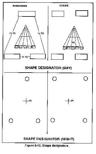
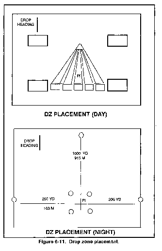
a. During day operations,
the point of impact will be marked with a RAM (Figure 6-9) and
a shape designator patterned in either a triangle (for personnel
airdrop operations, or a square for CDS/HE airdrops (Figure 6-10).
b. Night markings will consist
of a shape designator (made of lights) placed at the point of
impact, one flanker light placed 200 yards/183 meters to the left
and right of the shape designator, and a trailing edge light placed
1000 yards/915 meters from the shape designator, or at the trailing
edge of the surveyed DZ whichever is closer to the PI (Figure 6-11).
c. During day operations,
authentication or identification of different sites can be accomplished
by specified drop times, alternating panel colors, or drop headings.
d. During night operations,
authentication or identification of different sites can be accomplished
by having one light in the shape designator replaced with any
color light, except white.
NOTE: Authentication markings
must be pre-coordinated with the aircrew.
e. Circular DZ markings must
be coordinated 24 hours in advance to determine the desired drop
heading.
f. Smoke, other than red,
may be displayed adjacent to, and on the downwind side of the
RAM/shape designator to assist in visual acquisition of the DZ
and to indicate the surface wind direction.
NOTE: The panels in the shape
designator are not elevated.
g. The Army ground unit commander
may position the PI anywhere on the "surveyed DZ" and
insert his forces as necessary to accomplish the mission. He must
make the PI location known to the supporting airlift and the DZST
leader in sufficient time to plan the mission. The GUC accepts
the responsibility for an off-the-DZ impact if he selects a PI
closer than 300 yards from any edge of the surveyed DZ.
NOTE: A 200-yard buffer
zone on the trail edge of the drop zone is required for personnel
if the PI is located closer than 300 yards from any edge of the
drop zone.
6-22. ASSAULT ZONE AVAILABILITY
REPORT
The Air Force has a listing
of all available drop zones that are approved for use. The list
is called an Assault Zone Availability Report. The AZAR is compiled
from input provided by 21 AF, McGuire AFB, NJ; and 22 AF, Travis
AFB, CA. It identifies CONUS drop zones, landing zones, and extraction
zones available for use by the Air Mobility Command.
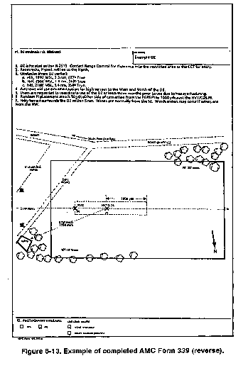
All needed information concerning
the drop zone is on the Air Force AMC Form 339 (Figure 6-12 and
6-13). The boxes on the AMC Form 339 are self-explanatory; however,
a detailed explanation is in AMC Regulation 55-60.

During Contingency/wartime
and major training exercise participation, DZST leaders maybe
expected to tactically locate and assess a potential drop zone
for follow-on airdrop resupply/reinforcement missions.
a. Normally, the Air Force
combat control teams would be tasked to accomplish this reconnaissance
type mission using the AMC Form 339; but when a CCT is unavailable,
the DZST leader may accomplish a tactical drop zone assessment
using the tactical assessment checklist for a guideline (Figure 6-14).
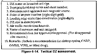
b. Airdrop operations on tactically
assessed DZs will be made ONLY under the following conditions:
-
(1) During training events,
the airdrop will be located within a military reservation or upon
US government leased property.
(2) The supported service
will accept responsibility for any damage that occurs as a result
of the airdrop activity.
(3) There must be adequate
time for safe effective planning.
6-25. AIRDROP/AIRLAND/EXTRACTION
ZONE CONTROL LOG
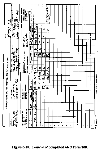
The AMC Form 168 is basically
a scorecard for the Air Force. Since the release point is computed
by the aircrew on the CARP drop zone, the Air Force must have
some documentation of the crew's performance. The DZST leader
fills it out. a. The following is an explanation of the blocks
on the AMC Form 168 (Figure 6-15). The individual named in blocks
2, 3, or 4 may all be the same person or may be different people.
-
(1) Location. Name
and grid coordinates of DZ/LZ/EZ.
-
E = Estimated
-
P = Paced
-
M = Measured
(2) CCT and unit. Name
of combat control team and unit controlling the DZ.
(3) DZ/LZ/EZ control officer
and unit. Name of the individual and unit controlling the
DZ.
(4) DZ safety officer and
unit. Name of DZ safety officer and unit.
(5) Legend. Explanations
of abbreviations used on this form.
(6) Line number. Each
line number on any given DZ mission represents an individual pass
over the DZ, even on a multiple aircraft DZ. For example, a three-ship
operation uses three lines. No-drop passes should use a line number
also, with the remarks column reflecting the reason for the no-drop.
(7) Unit. The unit
of the flight crew, usually a number designator.
(8) Call sign. The
correct call sign if you have radio communications with the pilot.
(9) Pilot/navigator. Last
name and rank of pilot and navigator.
(10) Type mission. The
letter designator in the legend for the type of mission.
(11) ETA. Estimated
time of arrival over target; it can be a hard time or a block
time.
(12) ATA/ATD. Actual
time of arrival or departure.
(13) Strike report. The
strike report yards/clock is the actual purpose of the 168. The
DZST leader observes the first parachutist, bundle, or heavy equipment
platform from the control center; he uses NVGs at night.
-
(a) He determines the distance
to the first parachute in yards and the clock direction in relationship
to the point of impact (12 o'clock is drop heading [magnetic]).
(b) If the first parachute
lands within 25 yards of the point of impact, then he puts the
letters PI in this block to indicate that a direct hit was made.
(c) If it was impossible to
maintain visual contact with the first parachute, especially during
multiple aircraft operations, then use an "S" or a "U"
(satisfactory or unsatisfactory) to score them. If 90 percent
of the parachutes land on the DZ,
then an "S" will be put in this column. If less than
90 percent land on the DZ, then a "U" will be put in
this column.
(d) If radio communication
is maintained with the drop aircraft, relay the strike reports
to the drop aircraft so that the aircrew can make adjustments
on following passes over the DZ. (14) AL/EX. For an airland/extraction,
enter an "S" or "U" as appropriate
(16) Score method. Mark which method was used to
determine the distance to the first parachute from the PI.
-
(a) Time. Note the time the
MEW was determined.
(b) Alt: Note what altitude
MEW was determined for.
(c) Direction and velocity.
The magnetic azimuth to the pilot balloon is measured and the
reciprocal heading noted. This will give the MEW direction to
be reported. When transmitting the MEW, make sure that the altitude
to which it was taken is included. Any indications of erratic
winds or wind shears should also be reported at this time.
6-26. AIR MEDICAL EVACUATION
REQUESTS
The following information
is necessary when requesting a MEDEVAC for casualties.
a. Location. Grid coordinates
will contain the six-digit grid location and be preceded by the
100,000-meter grid identification.
b. Radio/Frequency/Call
Sign. The frequency and call sign should be that of the radio
at the site of the unit requesting the MEDEVAC.
c. Patient Category of
Precedence. You should be prepared to classify the casualties
priority to be evacuated.
-
(1) Urgent: Within
2 hours to save life or limb.
(2) Priority: When
casualty's medical condition will deteriorate and become urgent
within 4 hours.
(3) Routine: Requires
evacuation, but when patient's condition is not expected to deteriorate
for several hours.
(4) Tactical immediate:
Evacuation needed so as not to endanger tactical mission.
e. Number and Type of Casualties.
Self-explanatory.
f. Security of Pickup Site.
Describe conditions of security.
g. Site Marking. Describe
marking method used.
h. Patient Nationality
and Status. Self-explanatory.
i. NBC Contamination Area.
Give location of NBC area.
* INDICATES ITEMS NOT NECESSARY ON CDS DROPS.
|
NEWSLETTER
|
| Join the GlobalSecurity.org mailing list |
|
|
|