

| THIS CHAPTER IMPLEMENTS
STANAGs 3218 AND 3619 AND QSTAG 585. |
Helicopter landing zones
contain one or more helicopter landing sites. A control center
is established at each landing site and a release point (manned
or unmanned) is normally selected for the LZ ( STANAG 3619).
The ground unit commander,
in coordination with the supporting aviation unit, selects the
location of helicopter LZs that support the ground tactical plan.
Minimum landing space requirements
and minimum distance between helicopters on the ground depend
upon a number of variables. These requirements are covered by
aviation unit SOPs, or they are prearranged by the aviation unit
commander in coordination with the pathfinder leader. The final
decision concerning minimum landing requirements rests with the
aviation unit commander. In selecting helicopter landing sites
from maps, aerial photographs, and actual ground or aerial reconnaissance,
the commander considers the following factors.
a. Number of Helicopters.
Animportant factor is the number of helicopters required
to land at one time at one site to accomplish the mission. It
maybe necessary to provide another landing site(s) nearby or to
land helicopters in successive lifts at the same site.
b. Landing Formations.
When they can, helicopters should land in the same formation
in which they are flying. However, planned formations may require
modification for helicopters to land in restrictive areas. If
a modification in flight formation is required for landing, use
the change requiring the least shift in the formation (Figure
4-1).

c. Surface Conditions,
Surfaces must be firm enough to prevent helicopters from bogging
down, creating excessive dust, or blowing snow. Rotor wash on
dirt, sand, or snow-covered surfaces may obscure the ground and
should be avoided, especially at night. Remove from landing points
debris that could damage the rotor blades or turbine engine(s).
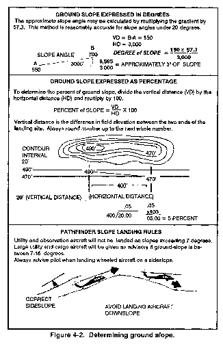
d. Ground Slope. The
ground should be relatively level and the slope should not exceed
7 degrees if the helicopter is to land safely (Figure 4-2). However, observation and utility helicopters can terminate
at a hover over ground slopes exceeding 7 degrees to load or to
off-load personnel or supplies. Large utility and cargo helicopters
can also land on terrain with a slope ranging from 0 degrees to
7 degrees. From a 7- to 15-degree slope, direct pilots to hover,
as appropriate. Make landings upslope whenever possible and avoid
landing downslope. NOTE: To determine slope in percentage or degrees,
all measurements may be expressed in feet or meters. If the elevation
on the map sheet is expressed in meters, convert meters into feet
by multiplying by three. If in feet, convert to meters by dividing
by three.
e. Approach and Departure
Directions. The direction of landing should be over the lowest
obstacles and generally into the wind, especially at night. However,
if there is only one satisfactory approach direction, or if it
is desired to make maximum use of the available landing area,
most helicopters can land with a crosswind of 6 to 9 knots or
a tailwind of 0 to 5 knots. For wind stronger than 9 knots, the
pilot lands into the wind. The same considerations apply to departures
from landing sites.
f. Prevailing Wind. Consideration
of approach and or departure routes is more important than that
of prevailing wind unless a crosswind velocity exceeds 9 knots.
The ability to land crosswind or downwind depends on the type
of helicopter. Small helicopters can accept less crosswind or
tailwind than larger, more powerful helicopters.
g. Density Altitude. The
density altitude is determined by altitude, temperature, and humidity.
For planning, as density altitude increases, the size of the LZ
must also be increased because high, hot, and humid conditions
decrease the lift capabilities of helicopters using that site.
h. Loads. Most helicopters
cannot climb or descend vertically when fully loaded. Therefore,
a large area and better approach/departure routes are required
for fully loaded helicopters than for empty or lightly loaded
ones.
i. Obstacles. Landing
zones should be free of tall trees, power lines, and similar obstructions
on the approach/departure ends of the landing site. Obstacles
within the landing site, such as rocks, stumps, holes, and thick
grass or brush (over 0.45 meter or 18 inches), must be removed.
For planning, an obstacle ratio of 10 to 1 should be used; that
is, a landing point requires 100 feet of horizontal clearance
from a 10-foot tree if helicopters must approach or depart directly
over the tree.
NOTE: The helicopter unit
commander makes the final decision on minimum landing requirements
based on the effects of air density, slope, and surface conditions.
These requirements should be available in oral instructions during
early mission planning.
Enemy action, unfavorable
terrain, or changes in the tactical or logistical situation may
require alternate landing sites. These are selected primarily
by the ground unit commander to support the tactical plan. On
the recommendations of the aviation unit commander and the pathfinder
on the site, the ground commander (or his representative) decides
when alternate sites will be used. Instructions concerning their
use must be given to pathfinders by the fastest means available.
Pathfinder and aviation unit commanders do not have the authority
to shift to an alternate LZ(s) unless such authority has been
specifically delegated by the supported ground unit commander.
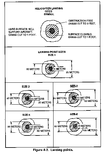
These are areas/points (designated
by the pathfinder leader) that can support the weight of a helicopter.
As a guide, a helicopter requires a relatively level, cleared,
circular area from 25 to 100 meters in diameter for landing. This
depends on the type of helicopter. The area around the landing
point must be cleared of all trees, brush, stumps, or other obstacles
that could damage the helicopter. Generally, a helicopter requires
more landing area during darkness than during daylight. Considerations
such as helicopter type, nature of load, climate, and visibility
affect what size landing point is used for a particular landing site.
a. The surface of the landing
point center must be level and sufficiently firm to allow a fully
loaded helicopter to land and, if necessary, to shut down, restart,
and depart without sinking into the ground. The term "hard
surface" indicates the proper condition.
b. The entire landing point
must be cleared of any loose material that could be blown up by
the rotors. The term is "cleared to ground level."
It would not, for instance, be necessary to clear grass up to
0.3 meter (1 foot) high that might cover a level field unless
a fire risk existed. A dusty surface can be stabilized with water,
if available. Snow can be packed to reduce the amount of blowing
snow and removed to reveal hazards.
c. If ground obstructions
cannot be cleared, some helicopter operations can be performed
without the helicopter landing. The same dimensions for clearing
and ground markings are required, but the helicopter hovers above
ground obstructions that prevent it from landing. However, every
effort is made by ground troops to improve landing point surfaces
to allow the aircraft to land.
d. Recommended minimum distances
between landing points within a landing site are measured from
center to center as follows:
-
Size 1 landing point . . .
. .25 meters.
Size 2 landing point . . . . .35 meters.
Size 3 landing point . . . . .50 meters.
Size 4 landing point . . . . .80 meters.
Size 5 landing point . . .
. .100 meters.
The pathfinder element is
task-organized to establish and operate the installations required
by the tactical plan of the supported unit(s). These facilities
may be within a single LZ or widely separated through-out a large
area of operations. The pathfinder leader is normally at the most
important site. For the establishment and operation of one helicopter
LZ, the pathfinder element is organized in two working parties--a control center and a landing site party (also called the marking
party). A landing site party is required for each site in the
landing zone. The control center party and the RP party provide
the same function for LZs or DZs.
The purpose of the CC is to
coordinate aircraft in and around an LZ or DZ and to promote a
safe, orderly, and expeditious flow of air traffic. The pathfinder
leader selects the exact location of the CC upon arrival in the
area. The CC is positioned to facilitate visual control of aircraft
in and around the LZ or DZ.
a. For helicopter landing
zones, the most desirable CC location is along the aircraft flight
route, but displaced from the landing site. This will reduce compromise
of the actual landing site location by enemy electronic warfare
assets, although the tactical situation might dictate that the
pathfinder leader be on the site for control purposes. When an
LZ has more than one landing site, or during reduced visibility,
the CC may be located to perform as a manned release point, or
final approach fix, to provide positive navigational assistance
to arriving aircraft.
-
(1) The RP is an established
traffic control checkpoint and the final navigational checkpoint
for aircraft approaching the landing site or air delivery facilities
within an LZ or DZ.
(2) The RP is also used by
helicopter serials as a final coordination point for control of
planned ground or aerial supporting fires in and around LZs during
the air movement phase of an air assault operation. The RP is
normally not manned unless extremely difficult navigational problems
are anticipated by the air movement commander. The location is
tentatively selected from map or air photograph studies as an
easily identifiable point on the planned flight route to the landing
site. If manned, the RP should be on terrain that allows maximum
effective use of long-range electronic and visual navigation aids.
c. A control center is organized
to meet mission requirements. It may consist of a single pathfinder
operating the GTA radio for a limited period at a small site,
or it may be staffed as follows:
-
(1) LZ or DZ commander.
He supervises aircraft landings and departures, airdrops,
and other pathfinder activities in the LZ or DZ He may also be
the GTA radio operator.
(2) GTA radio operator.
He operates the radio used to maintain communications with
pilots and provides the necessary advisories for his airspace.
(3) Internal radio net
recorder. He operates the radio used to communicate with other
pathfinder elements (when such a net is applicable and required).
He aids in the control of aircraft by observation and maintains
a record of aircraft arrivals/departures and the type loads (if
required).
The landing site party consists
of a site team leader and additional pathfinders/attached personnel,
as required. However, a single pathfinder may establish and operate
a small landing site for limited periods. a. The site team leader
is responsible for the reconnaissance, establishment, and operation
of the landing site. He supervises the site and, at any time,
may supervise the GTA radio operator. Some of his responsibilities
include:
-
(1) Organizes at an objective
rally point.
(2) Reconnoiters to determine:
-
(a) Long axis.
(b) Usable area.
(c) Ground slope (compute).
(d) Land heading.
(4) Designates slingload point(s).
(5) Emplaces and briefs GTA
radio operator.
(6) Clears touchdown and slingload
points.
(7) Organizes personnel and
loads for air movement.
(8) Clears or marks obstacles.
(9) Prepares for night/day
missions.
(10) Continues to improve
site.
c. Other personnel from supported
units may be attached to the landing site party to provide security,
assist pathfinders in establishing and operating the landing site,
reconnoiter and mark assembly areas, and operate assembly aids.
Attached personnel must be briefed and rehearsed. If they are
given a reconnaissance assignment, it should not include actual
landing areas; these areas are reconnoitered by pathfinders.
Once a site has been selected
and communications established, the operation of the site begins.
Additional markings and improvements are continually made until
the site is ready to support the ground tactical plan.
Communications are established
in the GTA net and the pathfinder internal net (if used) immediately
upon arrival at the landing site. These radio nets are monitored
at all times (unless otherwise directed) until operations at the
site are completed.
a. Each helicopter landing
site should be within ground communication range of the other
sites and RPs (if manned). However, the tactical situation may
preclude this requirement. The range of available radios dictates
the ability of facilities within the LZ to communicate with each
other.
b. The utility cargo helicopter
landing site commander rapidly reconnoiters the area to determine
the exact direction of landing. He calculates an intercept heading
from the RP, if necessary. He selects the location of the landing
point of the lead helicopter of each flight and determines if
the terrain or situation dictates any change to the planned landing
formation. The site commander must also ensure that landing instructions
are compiled for transmittal to inbound helicopters, and that
obstacles in or around the site are removed or marked.
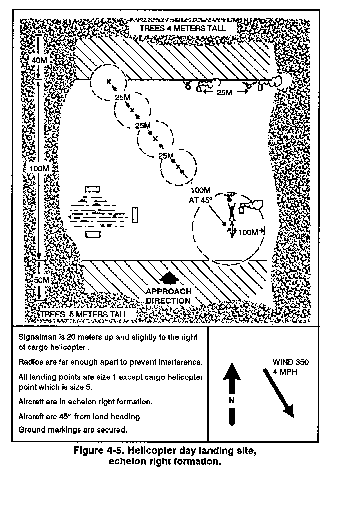
Helicopters should land simultaneously
in a planned flight formation. If it becomes necessary to land
in a formation different from that in which they are flying, the
landing site commander ensures that this information is given
to the flight leader as part of the landing instructions. The
exact layout of the landing site depends upon helicopters not
flying directly over other aircraft on the ground, available landing
space, number and type of obstacles, unit SOPs, and prearranged
flight formations.
4-8. LANDING ZONE AND OBSTACLE
MARKING
Normally, no LZ marking is
used for day operations except smoke or some other minimum identification
means. For night operations, lanterns or field expedients are
used to indicate the direction of landing and to mark individual
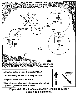
landing points (Figures 4-4 through 4-9).
However, obstacles should be marked for daylight and night air
assault operations.


a. At night, lights of different
colors may be used to designate different helicopter sites or
to separate flights within a larger formation. Alighted T or inverted
Y indicates the landing point of the lead helicopter of each flight
and the direction of approach (Figure 4-10). Additional
lights are provided for touchdown points of other helicopters
in the flight. Helicopters should land with the right landing
gear or skid just to the left of the light. (Red lights are avoided
because they mark obstacles.)
b. When helicopters are inbound,
all lights should be hooded or turned upside down for security
until the last practical moment. Lights should be beamed in the
direction from which the helicopters approach. A signalman should
be used to direct the landing of the lead helicopter.
The intensity of
lights may be too bright for NVGs, and colors cannot be seen through
the NVGs; therefore, an aircrew member may have to look under
the NVGs to distinguish the colors.
During daylight air assault
operations, obstacles that may be difficult to detect and impossible
to remove (such as wires, holes, stumps, and rocks) are marked
with colored panels or any other easily identifiable means (colored
red). During night air assault operations, red lights are used
to mark all obstacles within a landing site that cannot be easily
eliminated.
a. In most combat situations,
the need for security prohibits the use of red lights to mark
the tops of trees on the departure end of a landing zone. In training,
however, or in a rear area landing site, red lights should be
used whenever possible. If obstacles or hazards cannot be marked,
aviators should be fully advised of existing conditions by GTA
radio. In any case, the pathfinder landing site leader ensures
that the most dangerous obstacles are marked first and, if possible,
eliminated.
b. Pathfinders may mark initial
assembly points for troops, equipment, and supplies if required
by the supported unit. These points are located to facilitate
assembly and clearing of the helicopter site quickly and efficiently.
If unit assembly areas are to be used, they arc selected by the
ground unit commander. If necessary, supported ground unit personnel
accompany the pathfinders to reconnoiter and mark the unit assembly
areas, establish assembly aids, act as guides, and assist in landing
and unloading operations. Such help for pathfinders ensures the
rapid clearing of troops, supplies, and equipment from the landing
points.
c. Pathfinders have a limited
capability to secure a landing site. If they precede the initial
assault elements into a landing site, personnel from the supported
ground unit may accompany them for security.

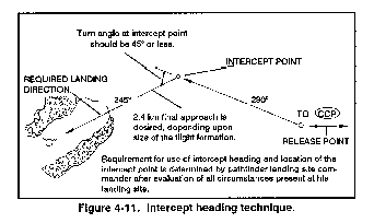
The heading from the RP (or
CCP if no RP is used) to the landing site coincides as closely
as possible with the landing direction to preclude sharp turns
by helicopter formations. The larger the formation, the more important
this becomes. If a straight-in landing approach is not possible,
then an intercept heading should be established (Figure 4-11).
The intercept point should be far enough from touchdown that it
allows helicopters in formation a final approach of at least 1
to 2 miles. Visual steering commands, time and distance, terrain
features, and electronic or visual navigation aids may be required
by flight leaders to determine the intercept point and the landing
direction at the landing site.
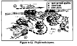
Helicopters approach the LZ
along a designated flight route. They are normally organized into
serials containing four or five helicopters but may be platoon-size
lifts. One serial may contain a flight for each helicopter site.
However, flights of medium or heavy transport helicopter (CH-47
and CH-54), carrying artillery or other bulk cargo, can often
be expected to arrive at LZs in increments of one or two helicopter
(Figure 4-12). Subsequent flights follow at minimum
time intervals, which depend on the number of helicopters per
flight, the configuration and conditions of the landing site,
and the nature of the cargo to be loaded or unloaded. The aviation
unit commander determines the time between successive flights
during planning. Once an operation is in progress, pathfinders
at the site may recommmend changes to ensure helicopter safety
or to expedite operations. (Night operations may increase the
time and distance between formations.)
4-11. COMMUNICATIONS CHECKPOINT
As each helicopter serial
reaches the CCP on the flight route, the flight leader contacts
the appropriate helicopter landing site control center. The CC
then gives the flight leader the heading from the CCP to the landing
site, the landing direction, and the following other pertinent
information:
-
The enemy situation.
-
Friendly Field elevation.
-
Landing formation.
-
Terrain conditions.
-
Traffic situation.
-
Obstacles.
-
Availability of smoke or light
gun.
-
Visual approach path indicator
setting.
-
The next reporting point.
NOTE: Pathfinders are
prepared at all times to provide ATC and navigation assistance
to all aircraft in and around the landing site in the event those
aircraft do not follow a specified flight plan.
b. The helicopter formation
continues along the flight route to the RP. Pilots are assisted
by the electronic and visual navigation aids at the RP (if manned).
All helicopters pass over or near the RP, and each flight RP (if
manned). All helicopters pass over or near the RP, and each flight
serial leader reports passage of the RP to his respective landing
site CC and then flies directly to his assigned landing site.
The individual landing site CC assists any flight that cannot
locate its site, using visual signals, steering commands, or electronic
homing techniques.
-
(1) Day operation signals.
For daylight operations, a specified smoke color may be assigned
to identify different landing sites. Since the number of smoke
colors is limited, the same color may have to be used by more
than one helicopter site. Sites that use the same color should
be farther apart. Smoke is employed sparingly because it marks
a location not only for friendly forces, but for enemy observers
as well. Generally, smoke is used only in response to a pilot's
request for help in identifying or locating his helicopter site.
(2) Night operation signals.
For night operations, pyrotechnics or other visual signals
are used in lieu of smoke. As in daylight, red signals mean do
not land, or they indicate other emergency conditions. Emergency
codes must be planned and understood by all concerned. Each flight
lands at its assigned site in the manner indicated by CC messages
and the visual aids displayed. Pathfinders may use arm-and-hand
signals to assist in controlling the landing, hovering, and parking
of helicopters.
As required, pathfinders
maybe tasked to manage ACPs to assist aircraft en route to the
LZ.
a. The ACP party consists
of two or three pathfinders, or at least one pathfinder with assistants.
They position and operate the electronic and or visual navigation
aids. They also operate radios in the pathfinder internal net
(if used) and the GTA net. Monitoring the GTA net permits ACP
personnel to respond immediately to requests from pilots for assistance
in locating an ACP.
b. The pathfinder in charge
of the ACP (assisted by available personnel as needed) installs
navigation aids immediately upon arrival at the site (or according
to plan). Whenever possible, aids should be established concurrently.
If a priority for installing these aids is required due to limited
personnel or other factors, then the following priority is used.
-
(1) GTA radio This
is placed into operation first. The electronic homing beacon is
then installed, if requested by the aviation unit commander, since
it affords long-range guidance. If used, the beacon must be far
enough away to prevent excessive interference with the radios
and to reduce the possibility of enemy fire destroying the radios
and the beacon simultaneously.
(2) Visual navigation aids.
These navigation aids vary in number and type depending upon
aviation unit SOPs and requirements, and the need for security.
Grass or brush masking these aids is removed, but a method of
concealing the markings is necessary if enemy aircraft is sighted.
(3) Pathfinder internal
net recorder He establishes communication with the landing
zone CCs as quickly as possible to report the state of ACP readiness
and to provide information on the enemy situation near his location
(if appropriate). He constantly monitors the radio unless directed
to operate a beacon on a definite time schedule.
(4) Security personnel.
The ACP party may include attached personnel from supported
units who are used to provide security. They move to assigned
locations and take up security positions or assist in establishing
and operating navigation aids and communications equipment.
Daytime visual references
(checkpoints for positive identification) are difficult to see
at night. Visual aids for night navigation emit illumination.
Too few visual references may cause pilots to concentrate on a
single light or a group of lights in a concentrated area. This
may induce visual illusions and can cause vertigo. To eliminate
this unsafe phenomenon, avoid marking LZs with a single light.
Landing areas should always be lighted with two or more lights
that are widely separated.
The tactical landing light
system provides visual cues for landing in a tactical landing
site. The inverted Y is the recommended system when the approach
is made from terrain flight altitudes. Approaches to a tactical
landing site are normally made without the aid of the search landing
light. The lighting for a tactical landing zone may consist of
hand-held flashlights or "beanbag" lights arranged on
the ground. Regardless of the type lighting device used, a minimum
of two lights will be used to identify the touchdown point.
a. At night, lights of different
colors maybe used to designate different helicopter sites or to
separate flights within a larger formation. A lighted (inverted)
Y indicates the landing point of the lead helicopter in the flight
(Figure 4-13). At additional touchdown points, helicopter should
land with the right landing gear or skid just to the left of the
light. All lights should be hooded or turned upside down for security
until the last practical moment when helicopters are inbound.
Lights should be beamed in the direction from which the helicopters
approach. A signalman should be used at a slingload point.

b. During darkness, approaches
are slightly steeper and slower than a daylight approach.
When fully night-adapted,
the eyes become extremely sensitive to light, and exposure to
a light source causes partial or complete loss of night vision.
Caution must be taken to avoid exposure of pilots to light sources.
When pilots are wearing NVGs, pathfinders must either avoid shining
the light directly at the aircraft. or else use only NVG compatible
light sources.
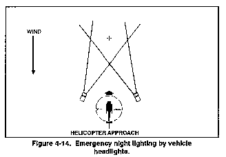
c. One example of emergency
night lighting is to use vehicle headlights. Place two vehicles
about 35 meters apart and 35 meters downwind of the landing point
with their headlight beams intersecting at the center of the landing
point (Figure 4-14). The helicopter approaches into the wind,
passes between the vehicles and lands in the lighted area. This
method is not suitable for large helicopters.
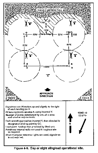
External load employment can
be difficult during darkness; however, several methods are available
to the pathfinder. In the absence of sufficient signalmen, reference
lights (three lights spaced triangularly 5 meters apart) are positioned
25 meters in front of the load as a marker. This lighting configuration
aids the flight-crew during hookup, lift-off, and landing. Upon
lift-off, the aircraft climbs vertically until the load clears
the ground. As the helicopter begins forward movement, sufficient
power is applied to maintain a climb that allows the slingload
to clear obstacles along the lift-off path. The shorter the sling,
the less altitude required to clear obstacles. Sling length should
be added to obstacle height for computation of the distance required
for departure clearance.
4-15. MULTI-HELICOPTER
OPERATIONS
Due to reduced vision at night,
formation flying cannot be safely conducted in a complete blackout
mode at terrain flight altitudes unless the unit is equipped with
night vision goggles.
To operate at terrain flight
altitudes during low- or mid-light levels, use night vision goggles.
Because the lights in the tactical lighting set are too bright
for these goggles, place a filter over the clear lens cover. If
a filter is not available, paint the lens cover or cover it with
plastic tape to reduce light intensity.
The pathfinder unit can anticipate
supporting the aviation commander and ground unit commander in
a variety of climates and terrains. The requirements for establishing
a landing site or zone are similar. However, some land areas require
extra precautions and care in the selection and preparation of
an LZ to safely and expeditiously receive aircraft.
It is important to remember
that the pilot (based on his experience and responsibilities to
aircraft and crew) determines whether or not a proposed landing
site is safe.
a. Climatic and terrain environments
include cold weather, jungle, desert, and mountainous terrain.
(For more detailed information on the climate, terrain, and operational
aspects of these areas, see FM 90-3, FM 90-5, and FM 90-6.)
b. Each area requires special
procedures on the part of the pilot. The pathfinder who is knowledgeable
regarding these procedures can better advise and assist aviators
and the supported ground unit.
Cold weather flying conditions
may be encountered in many parts of the world. Extreme cold and
blowing snow pose special problems in ground operations and flight
conditions. The problems presented by ice, snow, or rain are incorporated
into pathfinder mission planning. The pathfinder's knowledge of
flight procedures enables him to advise the pilot on the existing
surface conditions.
a. Communications. Radio
communications are generally good, but may be disrupted by electrical
disturbances (the aurora borealis). Some frequencies may be blocked
while other frequencies will not always permit operators to transmit
clearly. Communications are often limited or restricted by mountainous
terrain. Relay stations may have to be established. Conditions
of "radio skip" are prevalent in cold weather areas,
and it is common to experience long-distance radio traffic on
tactical frequency modulated networks.
b. Navigation. In snow-covered
areas with flat terrain, pilots may require RPs to be reamed and
marked. When flight is over loose snow, the movement of the air
picks the snow up and circulates it, forming a snow cloud. If
this condition exists, a phenomenon referred to as "whiteout"
may occur. Visibility is reduced to zero as the aircraft descends
or climbs through a snow cloud. The occurrence of whiteout conditions
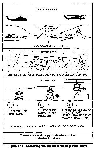
places additional requirements on the landing site party (Figure
4-15).
c. Surface Conditions.
The surface must be
evaluated to determine if aircraft can land without sinking too
deep into the snow. Testing the snow surface hardness can be done
with a tactical vehicle. The landing site party should also try
to determine the degree of ground slope and whether or not there
are any obstacles beneath the snow cover at each landing point.
-
(1) The distance between aircraft
is increased along with the size of the landing point: 100-meter-diameter
landing point with 100 meters between aircraft.
(2) Marking the landing points
presents other problems. Pilots lose depth perception in snow-covered
areas. A signalman on the ground provides a good reference for
estimating height. Touchdown points in daytime are marked so the
pilot has references to clear and safe landing areas.
(3) The GTA radio operator,
if the tactical situation permits, advises the pilot of the surface
conditions so he may anticipate how to make an approach. The echelon
left or right landing formation is preferred to reduce the chances
of snow clouds or whiteouts for the other aircraft. The pathfinder
should also plan to stagger aircraft arrivals to the landing site
to allow for the settling of snow clouds from preceding aircraft.
(4) Depending on the mission
requirements, climatic conditions, and the time the landing site
is used, the pathfinder leader considers the use of multiple landing
sites instead of only one site.
(5) Aircraft making night
approaches to snow sites require a reference point on-the ground
(tactical landing lights or runway lights). These lights provide
the pilot with a reference for judging angle of descent and rate
of closure. The pilot plans his approach to land short of the
touchdown point to ensure that he will not overshoot the point
and have to decelerate rapidly in a snow cloud. Approaching short
allows the pilot to maintain airspeed after the level-off, thus
keeping the aircraft in front of the snow cloud until touchdown.
(6) The pathfinder, if coordinated
with the flight commander, may adjust his inverted Y forward 10
meters in front of his designated number 1 touchdown point. This
allows the landing site party to employ all usable areas on the
site.
(7) If personnel are available,
they may be positioned to act as signalmen for aircraft approaching
additional touchdown points. Caution is exercised to ensure that
signalmen are in safe areas as aircraft approach and land. Additional
signalmen should also control the loading of personnel on the
aircraft (as instructed by the crew chief or the crew) when the
aircraft is ready to be loaded.
e. Slingload Operations.
Hookup and lift-off with a slingload over snow can be unsafe
unless the pilot anticipates being engulfed by a snow cloud. (The
CH-47 requires a sling length of at least 60 feet. The sling length
for other aircraft is shorter.) The usual technique of hovering
the helicopter over the load and attaching the sling to the hook
mayor may not be used over snow-covered terrain.
-
(1) An alternate procedure
for hooking up a slingload is for the pilot to land the helicopter
to the left of the load but close enough so that the sling can
be attached to it.
(2) When ready for lift-off,
the pilot initiates a slow, vertical ascent with enough lateral
movement to position the aircraft over the load. He continues
a vertical ascent until the load is off the ground and a hover-power
check is completed. When the load is clear, the pilot begins acceleration
while continuing to climb.
Ground personnel should be properly dressed and equipped with face mask and goggles due to the increased danger of frostbite from the rotor wash. |
f. Static Electricity.
During cold weather, static electricity creates serious problems.
It can be generated by the movement of an aircraft through the
air, by brushing snow and ice from the aircraft, or by dragging
steel cables over the snow. During external load operations, aviators
should key the FM radio immediately before load pickup to discharge
the aircraft's static electrical charge. However, the charge rapidly
builds up again. Therefore, hookup personnel should use a grounding
device to avoid electrical shock (Chapter 6, static probe).
g. Safety Considerations.
The accumulation of ice on aircraft structural and moving
parts may be dangerous to nearby ground personnel. The aircraft
may accumulate ice up to three-quarters of an inch thick during
flight in temperatures and altitudes where icing conditions exist.
During flight at less extreme temperatures, this ice begins to
loosen and fall off. Ice may shed while the helicopter is losing
altitude during the landing approach and during touchdown, and
pieces of ice shed by the main rotor may travel up to 300 feet.
Ground personnel should stay a safe distance away from helicopters
during landingdhutdown(after flight in icing conditions), and
passengers should not get out until the rotor blades have stopped.
Jungle areas impede military
operations and tend to obstruct military lines of communication.
Jungle areas maybe characterized by heat, humidity, rainy seasons,
and other weather conditions that affect the performances of aircraft.
Thick vegetation, irregular terrain, and adverse atmospheric conditions
screen radio transmissions. Radio relays may have to be used.
The CCP may have to be manned and marked, and GTA communications
provided to advise and direct the pilot to the landing site if
communications are limited in range.
a. Landing sites in the jungle
are generally small and may accommodate only a few aircraft. The
ACL will be drastically reduced. The surface conditions of the
landing site should be evaluated to ensure that the aircraft will
not sink or bog down in the soil. The site is surveyed for vines,
trees, and other obstructions in the approach path and near the
touchdown point.
b. On the approach, the pilot
avoids a high rate of descent. The aircraft angle of descent should
be steep enough to permit clearance of any obstacles. Normally,
a 10-to-l obstacle ratio is used, but the ratio can be reduced
to no less than 5 to 1. The pathfinder leader considers obstacle
height on approach and departure ends. Due to density altitude
problems in tropical areas, the aircraft may not be able to develop
enough lift to clear tall obstacles. When the size of the site
and terrain conditions permit, the pilot may consider running
lift-offs and landings. However, a running-type lift-off may not
be possible in the jungle due to the size of the site, soft terrain,
and obstacles.
c. Depending on the tactical
situation, the use of lights in night jungle LZ operations maybe
restricted.
d. Site security is critical
to the success of the ground unit commander's mission. Due to
the cover and concealment provided by jungle terrain, landing
site security is difficult to accomplish. The pathfinder team
leader coordinates with the flight commander to set a specific
time period to light the site.
e. It is important that the
site is oriented to the direction of the wind and that departure
obstacle ratios are as low as possible due to climatic conditions,
jungle vegetation, and reduced lift capability of the helicopter.
The pilot will hover as low as possible and no longer than necessary
due to the aircraft's decreased lift efficiency caused by ground
effects.
The typical desert is a dry,
barren region, generally treeless and sandy. A region of environmental
extremes, it has violent and unpredictable changes in weather
and contains terrain that does not conform to any particular model.
While frequent clear days offer unequaled visibility and flight
conditions, a sandstorm can quickly halt all operations. Therefore,
successful desert operations require special training, acclimatization,
and a lot of self-discipline.
a. Communications. In
desert operations, the radio is usually the prime means of communication.
Radio range normally is good due to the low, rolling terrain.
However, because of the increased distance involved with military
operations in the desert, FM radio communications maybe inadequate,
especially when using the higher FM frequencies. High-frequency
radio equipment is essential. Factors attributed to communication
problems include poor electrical ground, and sand and dust entering
equipment. Because of increased distances between land force units
engaged in desert operations, helicopters maybe used to provide
air or ground relay, or to help deploy ground radio rebroadcast
facilities.
b. Navigation Assistance.
Many of the conditions experienced in cold weather operations
are similar to desert operations. Distances and altitudes are
also difficult to judge in the desert. The lack of definable terrain
features makes navigation difficult, especially at night and over
long distances. The sameness of the terrain makes it easier for
a pilot to become less attentive to his surroundings, and it may
be necessary to mark and man release points.
c. Landing Sites. The
climatic conditions in the desert will have a profound impact
on establishing and operating landing sites. The three most important
factors to consider are density altitude, wind, and sand (dust).
Sand on a landing site could produce brownout conditions similar
to those found in snow areas, and the same precautions are applicable.
Therefore rocky areas are preferable to sandy areas, hollows,
depressions, and sandy valleys.
d. Wind. Desert wind
generally dies down about sundown for an hour or two, and there
is also a calm before sunrise. At times the wind can achieve hurricane
force. In all deserts, rapid temperature changes invariably follow
a strong wind that often raises dense clouds of dust and sand.
Consideration should be given to the time of day when the landing
site will be operational.
-
(1) The extreme heat often
experienced in the desert also affects the aircraft's ACL. When
in support of a ground unit, the pathfinder leader coordinates
with the aviation element to determine the ACL per type of aircraft.
The distance between aircraft and landing point size are increased
in desert operations (100 meters between aircraft, 100-meter-diameter
landing points). In daylight hours, the touchdown points are marked
(sandbags painted a bright color or other expedient method). The
use of signalmen, if available, is encouraged.
(2) When establishing a landing
site, the pathfinder leader considers taxi procedures. When it
is necessary to taxi, the pilot gets the aircraft into a vertical
position as quickly as possible to minimize sand (dust) intake
by the engines and to avoid a brownout. He should avoid taxiing
over the same area repeatedly.
f. Landings. Running-type
landings should be used when possible to minimize sand intake.
If a running landing can be made, the touchdown roll is kept to
a minimum to prevent overloading the landing gear. If the terrain
does not permit a running landing, the pilot makes a landing using
an approach angle that is greater than the angle used for normal
approaches. A landing should not be made from a hover.
g. Safety Considerations.
Ground crew personnel should wear clothing that affords adequate
protection from the blowing sand created by rotor wash. Special
care should be taken to keep sand out of the eyes, ears, nose,
and mouth. The use of goggles, ear plugs, and cloth masks provide
adequate protection for facial areas. Other ground crew procedures
are similar to cold weather operations.
Mountains are characterized
by rugged, divided terrain with steep slopes and few natural or
man-made lines of communication. Weather in the mountains is seasonal
and fluctuates from extreme cold with ice and snow to extreme
heat. Although these weather extremes are important planning considerations,
the variability of weather over short periods of time also influences
operations.
a. Communications. Communications
are often limited or restricted by mountain terrain. To maintain
them within the area of operations, aircraft may have to restrict
operations to the vicinity of the unit or be assisted by additional
aircraft employed as radio relay stations. Pathfinder units may
have to establish radio relays at the RP and or CCP.
-
(1) Mountain operations are
the most demanding on aviation and require the pilot to use large-scale
terrain maps for precise flying.
(2) Since GTA communication
is degraded by intervening terrain, navigation assistance and
control over extended ranges may be difficult.
c. Density Altitude. In
the mountains, density altitude can vary significantly between
pickup points and landing zones and also at different times during
a 24-hour period. For example, density altitude will normally
peak in the late afternoon and reach its low point at dawn.
d. Mobility. The helicopter
is the principal vehicle for rapidly moving forces in the mountains.
During the offense, air assault operations may be conducted to
infiltrate forces into the enemy's rear area and to bypass or
envelop his defenses. In the defense, reinforcements and reserves
can be moved rapidly by helicopter.
e. Landing Sites. Airfields
for fixed-wing aircraft and multiple helicopter LZs in mountainous
regions are limited. When only single aircraft LZs are available,
in-flight spacing between helicopters is increased; this places
an additional load on each crew. When conducting multiship operations
into a small LZ, the pathfinder controller should allow sufficient
time between lift-off and landing for the turbulent air generated
by the aircraft during departure to stabilize. The pilot will
experience a loss of lift and turbulent conditions if spacing
between lift-offs and landings is inadequate.
-
(1) Mountain LZs are generally
sloped, rough, and small. Because of this, pilots must use extreme
care during touchdown. Depending on the angle of slope and available
torque, a normal slope landing maybe made. Due to the size of
cargo helicopters, some difficulty may be experienced in positioning
the entire fuselage in the available area. The pilot loses visual
reference to the ground when the cockpit extends over the landing
area. Direction must be given by the crew chief and the signalman
regarding the direction in which the helicopter should be maneuvered.
LZs should be established on the windward side since the wind
is more stable. However, location of the enemy is more important
than placing the LZs on a leeward or windward side.
(2) During a mountain approach
with uneven terrain surrounding the LZ, the pilot receives a poor
visual clue as to the actual aircraft altitude and rate of closure.
Where the terrain slopes up to the LZ, a visual illusion occurs,
giving the pilot an impression that the aircraft is too high and
the rate of closure is too slow. If the terrain slopes down to
the LZ, the feeling is that the aircraft is too low and that the
rate of closure is too fast. The employment of a signalman on
the ground will provide a visual reference for pilot control adjustments.
It maybe necessary to provide more than one signalman.
-
(1) Determine the size, slope,
amount of surface debris, and the area covered by shadows and
obstacles in and around the site.
(2) Determine the approximate
direction, speed, and characteristics of the wind.
(3) Assess the inbound route
if necessary. The aircraft may terminate at a hover to off-load
troops and supplies if the slope is too great to permit a landing.
(4) Assess the departure route.
Lift-off routes should be into the wind and over the lowest obstacles.
It is desirable to land the
aircraft into the wind; however, the terrain and its effect on
the wind may require that the pilot execute a crosswind landing.
When making a crosswind landing, the approach path should be planned
so that the wind is from the left side of the aircraft for single-rotor
helicopters. This condition assists the pilot in overcoming the
effects of torque, reduces power requirements, and aids in heading
control. Other considerations include vertical air currents, escape
routes, terrain contour and obstacles, and the position of the
sun.
It is desirable to have updrafts
on the approach path. The severity of the vertical currents encountered
(updrafts or downdrafts) may be more critical than landing into
the wind and may require a downwind approach.
There should be one or more
escape routes along the approach path that can be used if a go-around
is required.
4-24. TERRAIN CONTOUR AND
OBSTACLES
The terrain and obstacles
along the approach path should be low enough to permit the pilot
to conduct a shallow approach angle into the landing site. When
possible, select a landing point on or near the highest terrain
feature.
Although the wind direction and nature of the terrain are the primary factors in selecting an approach path, consideration should be given to the location of the sun relative to the approach path and the presence of shadows on the landing site. If the landing point is in a shadow, the approach path should also be in a shadow. This would eliminate problems encountered by the pilot when adjusting from one light condition to another. An approach directly into the sun must be avoided when the sun is low on the horizon.
|
NEWSLETTER
|
| Join the GlobalSecurity.org mailing list |
|
|
|