


K.4.0 UNCERTAINTY IN ENVIRONMENT TRANSPORT
The estimated movement of contaminants through environmental media such as soil, groundwater, surface water, and air is associated with uncertainties. These uncertainties are described in Sections K.4.1 through K.4.4, respectively.
K.4.1 TRANSPORT IN SOIL
This discussion on potential transport mechanisms is provided because 1) there may be other vadose zone transport mechanisms in effect in addition to what has been calculated; 2) there is insufficient information to determine whether any or all of the other transport mechanisms are active. The available data indicate that the primary vadose zone transport mechanism is advective flow through the interstitial spaces of the porous media. Recent observations of relatively immobile contaminants at depths of up to 38 m (125 ft) below the tanks are not fully explained with interstitial flow and may indicate there are other transport mechanisms in effect. These observations are currently the focus of a DOE program. The initial phase of the program is to determine if the observations are representative of extensive vadose zone contamination beneath the tanks or if they are related to other phenomena such as borehole contamination. The results from this program including subsequent phases are not expected to be available for several months.
All of the remedial alternatives would result in some waste tank release to the vadose zone. The impacts of these releases were predicted using the approach described in Volume One, Section 5.2.1. This approach required the mathematical definition of the waste tank releases (source terms), calculation of when and at what rate the release would move through the underlying vadose zone (vadose zone modeling), and calculation of when and at what rate the release would move through the underlying groundwater system and ultimately discharge to the Columbia River (groundwater models). A one-dimensional model capable of simulating partially saturated conditions was selected to calculate the transport of a waste tank release through the vadose zone to the underlying groundwater. The impact assessment of all the alternatives relied on a common conceptual model of the vadose zone, which included the geometry of each site (i.e., number and thickness of strata) where the releases would occur, the assumption that each strata was an isotropic and homogenous porous medium, that contaminant transport would be driven primarily by advection downward through the interstitial spaces of the various strata, that contaminant transport would be an isolinear process (i.e., independent of contaminant concentration), and that contaminant mobility as expressed by the distribution coefficient (Kd) parameter would remain constant in the various strata of the vadose zone. The conceptual model is the basis of the one-dimensional model used in the assessment approach.
Provided in the following subsections are discussions of 1) data on migration of past tank leaks in the vadose zone; 2) calculated transport of a past tank leak from tank 241-T-106 using the impact assessment assumptions; 3) potential vadose zone transport mechanisms other than what is inherently assumed in the impact assessment analyses; and 4) how the other potential vadose zone transport mechanisms could impact each alternative.
K.4.1.1 Past Tank Leaks
Sixty-seven of the 149 SSTs are assumed to leak (Hanlon 1995). The assumed leaking tanks are fairly evenly distributed in the 200 Areas with 32 assumed leaking tanks in the 200 East Area and 35 in the 200 West Area. There are no reported leaks from the 28 DSTs. The range of leak volume is from approximately 1,300 liters (L) (350 gallons [gal]) from tank 241-C-204 in the 200 East Area to 435,000 L (115,000 gal) from tank 241-T-106 in the 200 West Area. Total leak volume from all 67 assumed leakers ranges from 2.27E+06 to 3.41E+06 L (600,000 to 900,000 gal). Interim stabilization has been completed on all but five assumed leaking tanks. The tank identification number, date the tank was declared a leaker, estimated leak volume, estimated activity of leak, and date the tank was stabilized are provided in Table K.4.1.1.
Cesium (Cs) and plutonium (Pu) were transported to the tank farms in various waste streams. Both contaminants are relatively immobile in subsurface materials at Hanford and because of this immobility, are expected to be found near waste disposal sites (especially under ambient infiltration conditions) dispersed throughout the unsaturated materials and in groundwater in some instances, depending on the volume of liquid associated with the waste discharge or leak.
Information has been emerging that associates migration of several radioisotopes, including Cs and Pu, to depths of 30 m (100 ft) or greater with leaks from the waste tanks. There are two major sources of this data as follows:
- Downhole logging of existing drywells; and
- Discrete samples from a borehole completed in multiple stages to avoid cross contamination.
Downhole Logging of Drywells
DOE has a system of monitoring wells called drywells installed in the vicinity of each waste tank. The depth of these drywells varies, but they do not extend to the water table of the unconfined aquifer.
Table K.4.1.1 Summary of Tank Leak Estimates from Single-Shell Tanks
These drywells were installed as a way of detecting gamma emissions and serve as an indirect means of detecting or confirming waste tank leaks and mobilization of existing contamination in the vadose zone by other waste sources such a potable water line leaks. Until recently, the gamma emissions that were detected were indicative of undifferentiated radioisotopes. Such emissions have been detected in many of the drywells at depths ranging from ground surface to depths up to 38 m (125 ft) belowground surface. Recent improvements in the borehole logging detection equipment has resulted in the identification of specific gamma-emitting radioisotopes. Thus, previously characterized gross gamma contamination is now specifically linked to several radioisotopes. The most prevalent radioisotope detected was Cs-137, while other gamma-emitting radionuclides such as cobalt-60 (Co-60), europium-152 (Eu-152), and Eu-154 were generally found near the surface and are believed to be the result of spills (Brodeur 1996).
The improved geophysical logging uses a spectral gamma logging system (SGLS) with high-purity intrinsic germanium detection device to provide assays of gamma-emitting radionuclides near the drywells. The approach, data, and interpretation are provided in Brodeur 1995. Application of the improved logging equipment has resulted in additional information on conditions at the SX Tank Farm. Application of the improved logging equipment has resulted in additional information on conditions at the SX Tank Farm.
Ten of the 15 tanks in the SX Tank Farm are assumed or verified as leaking. Tanks in the SX Tank Farm have been verified as leaking as early as 1962 (Table K.4.1.1). The last reported tank to leak in the SX Tank Farm was in 1988. Cumulative estimated leak volume from this tank farm ranges from 5.02E+05 L (132,000 gal) to 6.31E+05 L (167,000 gal) as shown in Table K.4.1.1. Ninety-five drywells ranging in depth from 23 m (75 ft) to 38 m (125 ft) from ground surface were logged with the SGLS in the SX Tank Farm. The most abundant and highest-concentration radionuclide detected was Cs-137, which was detected in virtually every borehole (Brodeur 1995). The Cs-137 was detected at the following depths in several drywells: 23 m (75 ft) in drywells 41-09-03 and 41-08-07; 32 m (105 ft) in 41-09-04; 27 m (90 ft) in 41-11-10, and 38 m (125 ft) in 41-12-02.
Other human-made gamma-emitting radionuclides detected include Co-60, Eu-152, and Eu-154, which generally were found near the surface and are believed to be the result of spills (Brodeur 1995). The Co-60 was found in drywell 41-14-06 only and was detected a depth of 17 m (55 ft) to 23 m (76 ft) below ground surface.
The transport of Cs-137 in the vadose zone sediments at the Hanford Site is believed to be greatly retarded due to adsorption. The Cs would not be expected to be found at depths of up to 38 m (125 ft) if it were being transported via interstitial flow through the sediment pore spaces and under ambient conditions that include neutral pH and infiltration rates ranging from 2 millimeters (mm)/year to 10 centimeters (cm)/year. The detection of Cs-137 at this depth raises several questions concerning the active transport mechanisms. These questions and others are being addressed by DOE in a Resource Conservation and Recovery Act Groundwater Assessment of the S and SX Tank Farms (Caggiano et al. 1996) has recently been implemented. The improved borehole logging detection equipment provides information on the specific contaminant in the vicinity of the drywells, but there is still uncertainty on the lateral distribution of these contaminants within the vadose zone.
Borehole Samples from Multiple-Stage Well
The borehole sample data were collected as a part of a 1993 investigation (Freeman-Pollard 1994) of contaminant migration from a leak from tank 241-T-106. The data from the 1993 investigation consist of 43 split-spoon samples from borehole 299-W10-196. These samples were taken for physical, chemical, and radiochemical analysis in addition to spectral gamma geophysical logging of the borehole on eight occasions.
The 1993 subsurface investigation of the tank 241-T-106 leak was the third to be performed since the initial leak was discovered in 1973. The first investigation was conducted from June to August 1973 in which 16 single-cased boreholes were drilled, the deepest to approximately 27 m (88 ft) below ground surface, as summarized in the 1993 investigation report (Freeman-Pollard 1994). Samples were collected at 1.5-m (5-ft) intervals as the boring was advanced. From this investigation, it was concluded that contamination penetrated to a maximum depth of about 27 m (88 ft).
Freeman-Pollard indicates that in 1979, a second investigation was completed based on numerous additional single-cased boreholes drilled between 1973 and 1978 (Freeman-Pollard 1994). One of the conclusions of this investigation was that there was no evidence that contaminants from the tank 241-T-106 leak had reached the underlying aquifer nor would it during the "hazardous lifetime" of the radionuclides. The 1993 investigation resulted in data on the vertical distribution of several radionuclides and chemicals. Most notably are the following results.
- The Pu concentrations increased greatly at the depth of the bottom of the tank 11 m (36 ft) below ground surface, reached a peak at 13 m (43 ft), decreased to less than 1 pCi/g at 28 m (92 ft), spiked at 29 m (95 ft), and then decreased to background at greater depths.
- The Cs-137 was the only radionuclide that had a high concentration within the fill around the tanks to a depth of 4 m (13 ft) below ground surface, above the presumed depth of the tank leak. The concentration decreased to a depth of 9 m (30 ft), then began to increase to a maximum at 14 m (46 ft), followed by a decrease to below background until two spikes were detected at 24 m (78 ft) and 30 m (100 ft).
- The spikes at approximately 30 m (100 ft) are observed for both mobile (e.g., Tc-99) and attenuated (e.g., Cs-137) contaminants and may be concentrated by a caliche layer that occurs at this depth. This may be due to a hydraulic conductivity contrast, adsorptive capacity from the increased clay content, and/or substitution of radionuclides in the calcium carbonate.
From the 1993 investigation, it was concluded that the mobile contaminants in the leading edge of the plume such as Tc-99 from the 1973 leak had penetrated to the contact with the Ringold unit E at 37 m (121 ft) below ground surface (Freeman-Pollard 1994). This represents a distance of 26 m (85 ft) over approximately 10 years. There was a spatial distribution of radioisotopes in the vadose zone that reflected the differences in their mobility (Freeman-Pollard 1994). At shallow depths, 10 to 24 m (33 to 82 ft), the less mobile or relatively immobile contaminants Cs-137, americium-241 (Am-241), Pu-239/240, Eu-154, strontium-90 (Sr-90), and C-14 were found. Carbon is assumed to be a mobile (Kd = 0) contaminant in Hanford Site sediments, thus its inclusion here is unclear.
K.4.1.2 Transport of Mobile Contaminants Associated with Past Tank Leaks
As stated previously, the groundwater impact assessments all are based on the assumption that contaminant transport occurs as the downward advection of water through the interstitial pores spaces of the various strata. It is difficult to provide an intuitive comparison between contaminant distribution from past leaks and contaminant distributions in the vadose zone calculated for the Tank Waste Remediation System (TWRS) alternatives because the volumes and rate of volume released from the TWRS alternatives generally would be much lower than the past tank leaks, specifically, the leak from tank 241-T-106. The leak from tank 241-T-106 was estimated to be approximately 435,000 L (115,000 gal) over a 52-day period. Contaminants from this leak have been identified in the vadose zone at depths of up to 30 m (100 ft) below ground surface. Scoping calculations consisting of two vadose zone simulations of the tank 241-T-106 leak were performed using the major assumptions used for the impact assessment described in Volume Four, Appendix F to provide a comparison of predicted contaminant distribution from the leak to observed contaminant distribution. A brief description of the simulations and the results follow.
The vadose zone model (VAM2D) was used to perform two axi-symmetric simulations of the vadose zone transport of contaminants due to a leak from tank 241-T-106. The upper boundary of the model was taken as the bottom elevation of the tank. The model domain extended a distance of 52 m (170 ft) from the upper boundary to the water table. Strata thicknesses and properties were the same as assumed for source area 1WSS for the impacts assessments in Volume Four, Appendix F. The axis of symmetry is the centerline of the tank, which has a radius of 11 m (37 ft). For both simulations, the flow field is first equilibrated to steady-state conditions, assuming no flow from the lateral boundaries, a zero pressure head along the bottom boundary, which represents water table conditions, and a spatially varying infiltration rate along the surface domain. The infiltration rate is zero for the domain from the centerline to 11 m (37 ft) radially to represent the umbrella effect of the tank. From 11 m (37 ft) to 111 m (365 ft), infiltration is 10 centimeters (cm)/year (4 inches [in.]/year) to represent enhanced infiltration due to the gravel surface around the tank. From 111 m (365 ft) to 161 m (530 ft), the infiltration rate drops linearly from 10 cm/year to 2 millimeters (mm)/year (4 to 0.08 in./year). Beyond 161 m (530 ft) to 1,500 m (4,900 ft), the infiltration rate is 2 mm/year (0.08 in./year), representing ambient conditions on relatively undisturbed land.
Both simulations assumed the leak to be 435,000 L (115,000 gal) over a 52-day period infiltrating into an area of 10 square meters (m2) (1,000 square feet [ft2]) at the centerline of the tank. The first simulation assumed the leak as described is superimposed on the infiltration scenario (no infiltration under the tank). The second simulation assumed that there would be an infiltration rate of 10 cm/year (4 in./year) over the domain from the tank centerline to 11 m (37 ft). Beyond this distance, the infiltration rate was assumed to be the same as described above. Table K.4.1.2 summarizes the calculated travel distance and elapsed time for the contaminant front from the tank 241-T-106 leak. This is for a mobile contaminant (Kd = 0) and the major assumptions used for the impact assessment.
For a mobile contaminant such as Tc-99, the above described simulations agree with the observation from the 1993 investigation of the tank 241-T-106 leak (Freeman-Pollard 1994) where it was found that Tc-99 had penetrated 37 m (120 ft) below ground surface. The 1993 investigation also indicates that normally much less mobile contaminants such as Cs-137 and Pu were found at nominal depths of 30 m (100 ft). This could be the result of an additional transport mechanism(s). Several potential transport mechanisms could be contributing to the transport of Cs-137 and Pu to depths of 30 m (100 ft). DOE currently has undertaken an investigation that should provide the information needed to ascertain if other transport mechanisms such as preferential flow paths and/or chemically enhanced mobility of selection contaminants are active.
K.4.1.3 Potential Vadose Zone Transport Mechanisms
In this section, potential vadose zone transport mechanisms are identified. The potential vadose zone transport mechanisms are divided into two categories: transport mechanisms controlled by physical processes and transport mechanisms controlled by chemical processes. Included in this discussion are occurrences or phenomena that could enhance or speed up contaminant transport in the vadose zone.
K.4.1.3.1 Potential Physical Vadose Zone Transport Mechanisms
Physical transport mechanisms can be either natural or human-made. Potential physical transport mechanisms and transport enhancing phenomena that could occur at the tanks include the following:
- Advective flow through clastic dikes and clastic sills that might naturally occur beneath and/or near the tank farms;
- Advective flow through breaks in the caliche layer (where it occurs) in the Plio-Pleistocene unit of the Ringold Formation that might naturally occur beneath and/or near the tank farms;
- Advective flow through the unsealed annular space surrounding the well casing and borehole in drywells/monitoring wells installed near the tanks;
- Infiltration of surface runoff into the unsealed annular space between the well casing and borehole in drywells/monitoring wells installed near the tanks;
- Inflow of surface water into the top of drywells and discharge out through casing perforations at depth;
- Movement of contamination during drilling from near-surface sources to various depths; and
- Near surface leaks from water lines and/or waste transfer lines.
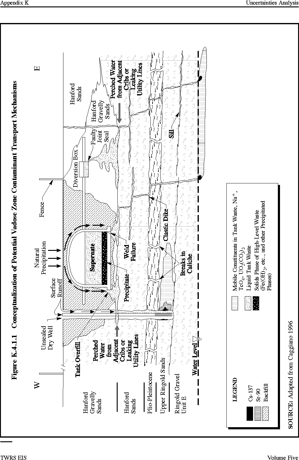
Each of the identified potential physical transport mechanisms listed are illustrated conceptually in Figure K.4.1.1. In the following paragraphs, a description of the potential transport mechanisms is provided.
Advective Flow Through Clastic Dike and Clastic Sills
Clastic dikes are ubiquitous in the 200 Areas and have been observed in the excavation of most major facilities in the 200 Areas including processing facilities and waste tanks (Fecht-Weekes 1996). Clastic dikes are lenses or tabular bodies, relatively narrow 18 to 38 cm (7 to 15 in.) (Fecht-Weekes 1996), with textural characteristics similar to the host sediment (clay and sand). Clastic dikes occur as near-vertical sediment-filled structures that cut across bedding planes of the Hanford Formation. Clastic sills are tabular structures of sedimentary material similar to clastic dikes but they are oriented parallel to the plane of the surrounding sediments. Figure K.4.1.1 depicts a conceptual cross section under a tank farm and includes an illustration of what a clastic dike and clastic sill would look like if exposed in an excavation. Clastic dikes have been observed to form polygons, based on observations of the Environmental Restoration Disposal Facility (ERDF) excavation (Fecht-Weekes 1996). A multisided polygonal cell encloses the host sediments. Individual polygonal cells are bounded by other polygons to form what is described as a honeycomb pattern when viewed from the air. The genesis of clastic dikes in not certain. There are several theories but the evidence is limited and does not conclusively support one theory. As with the genesis of clastic dikes, little is known about their hydraulic characteristics. Some inferences can be made from material descriptions where they have been intercepted by excavations and the lack of discernable impacts to groundwater levels and quality. The margins or vertical boundaries of clastic dikes are characterized by "clay skins," which are thin silt laminae that vary in thickness from 0.2 to 1 cm (0.08 to 0.4 in.). Internally, the dikes are composed of unconsolidated sedimentary infilling that trend parallel to the dike walls (Fecht-Weekes 1996).
The degree to which clastic dikes would function as a conduit (preferential flow path) or barrier to flow would depend on the relative amounts of clay and sand in the clastic dike and the continuity of any sand stringers within the clastic dike. Based on the observations of clastic dikes in excavations on the 200 Areas Plateau, the inferred hydraulic nature of the dikes is that of potentially a minor barrier to flow perpendicular to the dike. The clay content and lack of sand stringer continuity suggests that clastic dikes do not function as preferential flow paths for vertical flow.
Figure K.4.1.1 Conceptualization of Potential Vadose Zone Contaminant Transport Mechanisms
Advective Flow Through Breaks in the Caliche Layer in the Plio-Pleistocene Unit
Caliche layers generally would be a barrier to downward migration of contaminants in the vadose zone, if the layers were sufficiently extensive. Caliche layers were not included as discrete layers in the vadose zone modeling of contaminant transport. The Plio-Pleistocene unit, in which caliche layers generally are found, was included in the modeling assessment for source areas in the 200 West Area, and appropriate average material properties for this unit were used (Wood et al. 1995).
The presence of an intact, laterally extensive caliche layer would promote lateral spreading of infiltrating water. As a potential transport mechanism, breaks in the caliche layer in the Plio-Pleistocene unit would result in less lateral spreading and could allow for faster downward contaminant transport. Such breaks would function as a preferential flow path but only over a relatively short vertical distance. The overall thickness of the Plio-Pleistocene unit assumed for the vadose zone modeling assessments varies from approximately 4 to 5 m (13 to 16 ft) and caliche layers within this unit would be expected to be from 0 to 1 m (0 to 3 ft) thick.
Advective Flow Through the Unsealed Annular Space in Drywells and Groundwater Monitoring Wells
The unsealed annular space between the well casing and borehole in drywells affords the potential for 1) mobilizing contaminants that may be located at various elevations adjacent to the drywell; and 2) providing an additional driving force that could mobilize contaminants from past tank leaks that have migrated deeper into the vadose zone but not necessarily adjacent to the drywell.
Drywells and older groundwater monitoring wells have been installed near each tank for environmental monitoring and were drilled through near-surface contamination from tank leaks and other releases. These wells all were constructed with a cable tool drilling method in which the steel casing was driven down as the bottom of the borehole was cleaned out with the cable tool. A hardened steel drive shoe with a outside diameter larger than the casing diameter (diameters vary with driller and with available materials) by approximately 1.3 cm (0.5 in.) was attached to the bottom of the casing as it was being driven down the borehole. The annular space between the casing and borehole was not sealed. In the drywells, perforations in the steel casings have been made at various depths. The groundwater monitoring wells were installed with a screened section at the bottom that typically extended from 3 m (10 ft) above the water table to 6 m (20 ft) below the water table.
Drywells are similar to the older groundwater monitoring wells (Figure K.4.1.1) in the tank farm area except that drywells do not extend to the groundwater table and perforations in the drywells were made at various elevations. Drywells were installed to allow for periodic monitoring of radioactivity in the vadose zone from ground surface to the depth of the drywell. Increases in radioactivity detected in the drywells were indicative of a tank leak or migration of existing radioactivity in the vadose zone in response to another water source such as a leaking water line.
The hydraulic characteristics of the annular space between the well casing and borehole are not known. Because this space was not sealed and a drive shoe with larger outside diameter than the casing was used, there exists the potential of voids and loosely packed sand and gravel that potentially could function as a preferential flow path for contaminant migration vertically through the vadose zone.
Infiltration of Surface Runoff into the Unsealed Annular Space of Drywells/Monitoring Wells
Infiltration of surface water or other near-surface liquid sources such as from a leaking water line (Figure K.4.1.1) has the potential for 1) mobilizing the near-surface contamination through which some of the wells were drilled; and 2) providing an additional driving force that could mobilize contaminants from past tank leaks that have migrated deeper into the vadose zone.
Large volumes of water, such as flooding of drywells, have been known to occur at some of the tank farms and water line leaks have been extensive enough to cause surface subsidence. Water sources such as described, combined with potential preferential flow paths created by unsealed annular spaces of drywells and monitoring wells could result in the mobilization of near-surface contaminants to greater depths within the vadose zone. Contaminants such as Cs-137, which are immobile in Hanford-type sediments under ambient conditions, would be expected to travel down the annular space with the saturation front and remain relatively close to the drywell. Mobile contaminants such as Tc-99 also would travel down the annular space with the saturation front but would be able to move farther laterally than less mobile contaminants, especially if lower conductivity units such as a caliche layer were encountered, which would promote lateral spreading. This potential phenomena is illustrated in Figure K.4.1.1.
The potential mobilization of near-surface contaminants as described also could apply to contaminants that are deeper in the vadose zone such as might occur from a past tank leak. The Cs is not expected to migrate far from the tank under ambient conditions and advective flow through the interstitial pore spaces of the sediments. Thus, a Cs plume from a past tank leak would have to intercept the annular space near the leak for Cs-137 to be mobilized and transported deeper in the vadose zone via the potential annular space pathway (Figure K.4.1.1).
Inflow of Surface Water into the Top of Drywells
This potential transport mechanism entails pipe flow down the inside of the drywell casings. The construction of drywells is discussed previously. Inflow of surface water into the drywell casings has the potential of mobilizing the deep-seated contaminants from past tank leaks or other sources by providing an addition driving force.
As discussed, large volumes of water such as flooding of drywells, which has been known to occur at some of the tank farms potentially could enter drywell casings. If sufficient water from sources such as this enter the drywell casings, they would flow out of casing perforations and/or the bottom the casing if unsealed. This could result in the mobilization of deep-seated contaminants. This potential transport mechanism would not affect contaminants such as Cs-137, which are immobile in Hanford-type sediments under ambient conditions unless there are casing perforations near the elevation of the bottom of the tank leak and/or the Cs-137 was transported to a greater depth via a transport mechanism such as one involving a preferential flow path or chemically enhanced movement.
Movement of Contamination During Drilling
This potential transport mechanism involves the physical movement of particles during the drilling process from a higher elevation to a lower elevation. Many of the drywells were drilled through near-surface contamination. In addition, the drilling was not staged to prevent cross-contamination, the annular space between the single casing and the borehole was not sealed, and the cable tool drilling method potentially could carry near-surface contaminants to a greater depth. The impact on the underlying groundwater would be expected to be insignificant. Such occurrences could complicate data analyses or cause misinterpretation of data collected from the drywell monitoring programs.
Near-Surface Leaks from Water Lines And/Or Waste Transfer Lines
Even in the absence of potential preferential flow paths such as the annular space between well casings and boreholes or clastic dikes, large volumes of water such as from water line leaks, construction activities, or surface flooding could provide a driving force to quicken the transport of contaminants at all elevations.
K.4.1.3.2 Potential Chemical Vadose Zone Transport Mechanisms
As discussed in the introduction to this section, potential chemical-related transport mechanisms are the least understood of all the transport mechanisms especially considering the extremely high pH liquors present in the waste tanks. However, as will be discussed in the following paragraphs, chemical-related transport mechanism(s) may be responsible in part for the observation of contaminants such as Cs-137 at 38 m (125 ft) below the SX Tank Farm, which is deeper in the vadose zone than would have been expected based on the present understanding of the leak volume and contaminant mobility in the near-tank environment.
Potential chemical transport mechanisms may be associated with 1) sodium (Na) from the waste tanks and its effect on the mobility of some contaminants; 2) the reaction of hydroxide in the waste tanks with minerals in the vadose zone resulting in greater mobility of otherwise relatively immobile contaminants; and 3) the reaction of complexing agents that may be in the waste tanks with otherwise relatively immobile contaminants such as Co-60 and Sr-90 causing them to be more mobile. Potential chemical transport enhancing phenomena that could be in effect at the tanks include enhanced mobility resulting from; Na exchange, dissolution, and formation.
Enhanced Mobility Resulting from Sodium Exchange
Many of the defense mission processes involved acid dissolution. The resulting waste was neutralized with sodium hydroxide before being routed to the waste tanks. This practice has resulted in the presence of Na in the tank wastes at high concentrations and high pH (e.g., pH 12). As a consequence, Na may exchange for naturally occurring divalent cations such as calcium (Ca) and magnesium in the soil column. At high pH values, such as would occur when the tank contents had first exited the tanks, the surfaces of the mineral particles would be negatively charged and would attract cations. The presence of high Na concentrations near these mineral surfaces could cause the desorption of other ions from the mineral surfaces as shown in the following equation modified from Caggiano 1996:
mNa+ (bulk solution) + nCa++ (mineral surface
double-layer) =
xNa+ (mineral surface double-layer) + yCa++ (bulk
solution)
This exchange process could result in more divalent cations reaching the groundwater and less Na than expected. This is consistent with observations and groundwater quality analyses from a well downgradient of the S and SX Tank Farms. An important consequence is that, under high Na conditions, Sr-90, which is chemically similar to Ca, may likewise be mobilized and migrate to a greater extent than previously expected. Other waste tank constituents may be affected similarly.
Enhanced Mobility Resulting from Silicate Mineral Dissolution
The neutralization of the wastes with sodium hydroxide meant that the tank contents were high pH, sometimes approaching a pH of 12. Many studies have shown that dissolution of silicate minerals such as those in the underlying vadose zone sediments would be accelerated at high pH and high temperature (Caggiano 1996). The dissolution reactions would occur when leaks from the tanks, some of which were self-boiling, contacted the mineral particles in the vadose zone. Such dissolution processes potentially could result in gelatinous reaction products that could cover the mineral exchange sites, which would enhance the mobility of contaminants such as Cs-137 that normally are retarded by exchange. However, the gelatinous reaction products could have the opposite effect by impeding moisture migration through the soil. This potentially could cause the soil permeability to be lower than that of the unaltered material, resulting in slower contaminant movement.
Another possible effect of silicate mineral dissolution is the leaching of previously adsorbed Cs-137. If the surface of silicate minerals in the vadose zone was dissolved, micro- and macropores could be opened. This in turn could lead to the leaching of Cs-137 that previously had been adsorbed. Heat from the tanks and the heat of leaking waste could increase the rate of silicate mineral dissolution and increase the Cs-137 release rate.
Enhanced Mobility Resulting from Complex Formation
Metal-organic complexes are compounds with a cyclic structure in which the organic components are bonded to the central metal ion. Millions of pounds of complex-forming organic chemicals such as citrate, glycolate and ethylenediaminetetraacetic acid (EDTA) were used for the recovery of U and Sr and subsequently discharged to the tanks. Once in the tanks, it would be possible for these complex-forming chemicals to react with other cationic constituents of the tank waste. Not all contaminants will react with organic complexing agents such as EDTA; generally, this interaction does not take place with monovalent cations such as Na, potassium, or Cs (Hill 1992). The Cs has very little potential for complexing with the organic chemicals found in the waste tanks. Complexing reactions may take place with other cations including the actinides and lanthanides. While it is known that metal-organic complexes will remain in solution under conditions where the metal ion itself would precipitate, there is a lack of data on the mobility of these complexes. Presumably, the complex would move relatively further and faster than the ion, but Kd values for metal-organic complexes remain a subject for future study and investigation. Also, the ability of the complexing agents to remain active in the presence of high temperature and ionizing radiation is uncertain.
K.4.1.4 Potential Impact on TWRS Alternatives
Most of the potential vadose zone transport mechanisms, if active, would result in earlier contaminant first arrival at the vadose zone/groundwater interface, earlier peak concentrations, and higher peak concentrations for some or all of the contaminants, depending on the mechanisms. The following provides a qualitative description of the potential impact of the vadose zone transport mechanisms on each alternative and mitigation measures where applicable.
Preferential flow through clastic dikes and sills would result in earlier contaminant first arrival and peak times and higher peak concentrations in groundwater for all alternatives and contaminants and would be difficult to mitigate directly. The dikes first would have to be located with methods that possibly could include surface geophysics and test pits. Then, a sealing material that would withstand the chemicals in the tank waste would have to be injected effectively into the structure. Alternatively, a grout barrier could be considered. Overall, it may be unlikely that clastic dikes and sills could be directly mitigated. For ex situ alternatives, an effective indirect mitigation would be to reduce retrieval loss volume and contaminant concentrations.
Flow through breaks in a caliche layer is not expected to impact any of the alternatives because "credit" was not taken for caliche layer attenuation in the impacts analyses. Flow through drywell annular space from TWRS releases would have an effect on the No Action and Long-Term Management tank waste alternatives similar to that described for clastic dikes and sills. Mitigating the effect of flow through drywells would be relatively easily accomplished with a drywell removal (plugging) and/or drywell rehabilitation program. The other in situ and ex situ alternatives presumably would not be impacted because the drywells would be removed and plugged prior to installation of a cap over the tank farms.
Inflow of surface water into the drywell casings and annular space could decrease vadose zone contaminant transport time for the No Action and Long-Term Management alternatives. The effect on peak concentrations is uncertain. Peak concentrations could be reduced due to the dilution effect of surface water in flow. Mitigation such as plugging could be performed as described previously. The other in situ and ex situ alternatives would presumably not be affected because the drywells would be removed prior to installation of a cap over the tank farms. Cross contamination during drywell construction would not have an impact on any of the TWRS alternatives. Near-surface leaks from potable waste and waste water could decrease vadose zone contaminant transport time for the No Action and Long-Term Management alternatives. Mitigation would be relatively easy and would involve the removal of all utility lines from the tank farms area. The other in situ and ex situ alternatives would not be impacted because the utility lines would be removed prior to installation of a cap over the tank farms.
The three identified chemical transport mechanisms would result in earlier contaminant first arrival at the vadose zone/groundwater interface, earlier peak concentrations, and higher peak concentrations for some of the otherwise relatively immobile contaminants for all of the alternatives except the In Situ Vitrification alternative. The potential effects of the Na exchange and sediment dissolution transport mechanisms could be limited to near-tank due to the dilution of Na and hydroxide with natural water and would be rendered totally inactive at the saturated water located at 65 to 85 m (210 ft to 270 ft) below ground surface. The potential effect of enhanced mobility from complexing agents and the extent into the vadose zone and groundwater remain a subject for future study and investigation.
Depending on the resolution of the transport mechanisms that are currently active, it might or might not be necessary to take additional measures to control leaks during retrieval and remediate contaminants in the soil during tank farm closure.
It is not known if any of the potential transport mechanisms are active. Further, the potential transport mechanisms involving chemical enhancement are poorly understood. Mitigation of the chemical-related transport mechanisms could include indirect approaches such as reducing the volume and concentration of contaminants released during retrieval. Direct mitigation may be effective but much more information is needed about this type of potential transport mechanism.
K.4.2 TRANSPORT IN GROUNDWATER
The analyses of potential impacts on groundwater required several assumptions to address uncertainties. The major assumptions and uncertainties either are related to natural variables (e.g., vadose zone and aquifer parameter values) or are inherent to the assessment approach. Modeling assumptions are described in Section 4.2.1.
Post-remediation health risks to the public from TWRS alternatives would result from contaminants in the groundwater. The first arrival of any contaminant at the interface between the vadose zone and groundwater would occur between 140 and 250 years following remediation with the Long-Term Management and No Action alternatives. The tank inventory would be released faster for these alternatives than for any of the other alternatives, because it is assumed that there would be no engineered barriers to reduce infiltration or any attempt to remove or stabilize the tank waste. The first arrival of contaminants from the other alternatives would occur at about 2,000 years and the peak concentrations at about 5,000 years in the future.
Cumulative radionuclide concentrations that could occur in the groundwater from a potential combination of contamination from past disposal practices, currently anticipated future waste disposal, and the contamination from the TWRS alternatives are discussed in Volume Four, Appendix F.4.5. Peak groundwater concentrations from the various potential sources may occur at different times and different locations. However, to maximize the potential cumulative impacts, the peak concentrations of the past and reasonably foreseeable future sources were assumed to combine with the peak concentrations from the TWRS alternatives. This results in a conservative bounding of the maximum potential cumulative groundwater impact for each TWRS alternative. A more detailed modeling of the potential cumulative impacts will be done in a future Hanford Site EIS. The results of the future analysis likely would indicate lower cumulative groundwater impacts than presented in this bounding analysis.
The highest cumulative groundwater concentrations occur for the No Action and Long-Term Management alternatives. The tank waste is the dominant contributor to the predicted concentrations. The other alternatives result in much lower cumulative radionuclide concentrations, and the dominant contributor is contamination from past disposal practices. The radiation dose and risk to the potential future user of the contaminated groundwater, the time at which it could occur, and the percent attributable to TWRS waste for each alternative are presented in Volume One, Table 5.13.5. The table is based on a hypothetical onsite farmer who is assumed to use the groundwater at the maximum cumulative point of concentration for each alternative. The groundwater is assumed to be used for all purposes, including drinking, washing, and gardening for 30 years. Future solid waste disposal at the 200 West Area solid waste burial ground and the ERDF collectively would contribute about 5 rem of the hypothetical 30-year resident farmer dose presented. Less than 10 mrem of the hypothetical 30-year resident farmer dose would be attributed to past and future solid waste disposal at the US Ecology solid waste burial ground.
K.4.2.1 Modeling Assumptions
Volume Four, Appendix F provides the basis of the groundwater impact analysis for the TWRS alternatives. The groundwater assessments in Volume Four, Appendix F required several assumptions to address uncertainties in some of the data. The major assumptions and uncertainties are related to either the natural system (i.e., an understanding and ability to assign vadose zone and aquifer parameter values) or uncertainties inherent to the assessment approach.
The most important assumptions and uncertainties are as follows:
- The rates of infiltration into natural ground and through a cap;
- Distribution coefficient (Kd) of contaminants;
- Uncertainty in future groundwater flow direction due to decay of groundwater mounds onsite and future land-use changes;
- Uncertainty in future groundwater flow direction and vadose zone thickness due to climate change;
- Uncertainty in vadose zone transport due to use of one-dimensional flow and transport simulation; and
- Uncertainty due to calculation of releases during retrieval.
Infiltration
Infiltration is one of the key driving forces for contaminant movement through the vadose zone. It affects the time of contaminant transport through the vadose zone: a higher rate results in a faster flow rate within the vadose zone and a shorter contaminant transport time.
Infiltration varies temporally and spatially. The temporal variation occurs seasonally with changes in temperature, plant activity, and precipitation and over longer periods as a result of climatic change. The spatial variation occurs with changes in vegetation type, surficial soil type, and human-made structures, such as paved parking lots. The vadose zone flow field varies temporally and spatially in response to infiltration rate changes. However, it is not directly measurable with conventional techniques and is modeled based on vadose zone parameters and the assumed infiltration rate. There is also a lag time between a change in infiltration rate at the surface and a change in the flow field in the vadose zone as the water percolates into the ground.
For each alternative, the initial infiltration rate (i.e., the rate before implementing remediation or no action) is assumed to be 5 cm/year (2 in./year). This rate is within the range of reported values for the Hanford Site and is appropriate given 1) the recent ground cover changes in the tanks vicinity; 2) the uncertainties in future ground cover conditions; and 3) the one-dimensional vadose zone flow and transport model used for the simulations. Infiltration in the 200 Areas is reported to range from near zero, where the ground cover is a shrub-steppe type characteristic of predevelopment conditions, to 10 to 13 cm/year (4 to 5 in./year), where the ground is unvegetated sand and gravel, characteristic of conditions around the tank farms since the mid-1940's or later (Gee et al. 1992). For alternatives that incorporate a cap, limited sensitivity analysis has shown that the contaminant transport through the vadose zone is not sensitive to the initial infiltration rate (Volume One, Section 4.3.5).
The higher infiltration in the vicinity of the tanks is a relatively recent occurrence in response to ground cover modifications in the last 50 years. These modifications are not expected to have changed the flow field at depth within the vadose zone from that of predevelopment conditions. For alternatives involving a cap, conditions after the cap is installed are assumed to be representative of predevelopment conditions in that the infiltration in the tank vicinity would be low. Infiltration is assumed to remain at 5 cm/year (2 in./year) for the No Action and Long-Term Management alternatives.
Spatially, the rate would be expected to be lower away from the tanks where vegetation is present and surficial soils are of a finer texture. The one-dimensional model used for contaminant transport simulations through the vadose zone does not account for these infiltration changes with time and space. Thus, the assumed infiltration rate of 5 cm/year (2 in./year) was chosen as a conservative estimate.
The No Action and Long-Term Management alternatives are the only two tank waste alternatives that would not involve placement of a cap over the tanks. If a higher infiltration rate was assumed (i.e., greater than 5 cm/year [2 in./year]), the result would be earlier contaminant arrival in the groundwater with higher peak concentrations. Conversely, use of a lower infiltration rate would result in a delayed effect with somewhat lower peak contaminant concentrations.
Distribution Coefficients
The various contaminants in the tank waste each have their own chemical characteristics and would interact with the groundwater and geologic materials differently. An indication of a contaminants mobility in the vadose zone and groundwater aquifer is the distribution coefficient (Kd). A contaminant moves with the speed of water if its Kd is zero and progressively slower than water as the Kd value increases. This difference would result in different rates of contaminant movement in the vadose zone and groundwater, ranging from that of groundwater to no measurable movement over a period of hundreds of years.
The tanks contain more than 100 radioactive and nonradioactive contaminants that potentially would impact groundwater. Contaminants that are insoluble were assumed not to leach to groundwater. The Kd values for the contaminants range from zero (in which the contaminant's movement in water is not retarded) to more than 100 (in which the contaminant moves much more slowly than water). Therefore, the contaminants were grouped as follows based on their mobility in the vadose zone and underlying unconfined aquifer:
- Group 1 - Nonsorbing (Kd = 0); Kd values in this group ranged from 0 to 0.99 mL/g;
- Group 2 - Slightly sorbing (Kd = 1); Kd values ranged from 1 to 9.9 mL/g;
- Group 3 - Moderately sorbing (Kd = 10); Kd values ranged from 10 to 49.9 mL/g; and
- Group 4 - Strongly sorbing (Kd = 50); Kd values are 50 mL/g or greater.
Contaminant transport simulations were performed for each group, using the lowest value of the range. These results were used to design a limited sensitivity analysis (Volume Four, Section F.4.3.5).
The distribution coefficient for a given contaminant depends not only on the chemical characteristics of the contaminant but also on the chemistry of the aquifer (or vadose zone) and the water within. For example, a contaminant with a Kd value of 0 in saturated sands might have a nonzero Kd value in a clay-rich zone. There is a large uncertainty with regard to contaminant mobility in all the different material and water types at the Hanford Site. For example, the Kd value of U has a reported experimental value that varies from a low estimate of 0 to a high estimate of 79.3 mL/g (best estimate value is 0.6 mL/g) in Hanford Site sediments with waters of neutral to high pH, low ionic strength, low organic content, and toxic solutions. In Hanford Site sediments with waters of neutral to high pH levels, low ionic strength, low organic, and anoxic solutions, this same contaminant has a reported experimental value that varies from a low estimate of 100 to a high estimate of 1,000 mL/g (best estimate value is 100 mL/g) (Kaplan et al. 1994).
Given the uncertainty in the mobility of U, U was initially assumed to have a zero Kd. Assuming a high Kd would mean the contaminant did not reach groundwater within the 10,000-year period of interest.
Vadose zone simulations show that U with an assumed Kd of zero does reach groundwater within the 10,000-year period of interest for all the alternatives and that drinking water standards are potentially exceeded. Based on these results, the sensitivity of the U mobility assumption can be better understood with additional simulations with slightly higher values of Kd. Vadose zone simulations indicate that contaminants with a Kd of 0.125 mL/g do not reach the groundwater within the 10,000-year period of interest, using the Ex Situ Intermediate Separations alternative as the base case.
Future Groundwater Flow Direction
Under present land use conditions, groundwater flow direction and gradient on the Hanford Site is dynamic and changes primarily in response to wastewater disposal to the vadose zone and future land-use changes. Other factors could influence groundwater flow and gradient to a lesser degree. These factors include irrigation to the west of the Site and water level in the Columbia and Yakima Rivers.
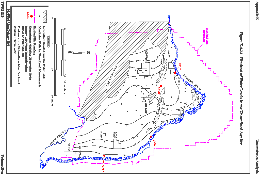
The groundwater impact assessment for the TWRS EIS was based on a conceptual model with the following salient features: 1) water movement from surface infiltration, tank releases, and other near-surface sources is through the vadose zone, into the underlying aquifer, and ultimately to the Columbia River, 2) flow and transport of water and contaminants in the vadose zone and underlying aquifer are by advection through the interstitial pore spaces of the sediments, 3) the Columbia and Yakima Rivers form hydraulic boundaries: the Yakima River recharges the unconfined aquifer in the southern part of the Site and the Columbia River receives discharge from the unconfined aquifer, 4) the Cold Creek and Dry Creek valleys recharge the unconfined aquifer, part of which is derived from infiltrating irrigation waters to the west of the Site, 5) the Rattlesnake Hills to the west of the Site are a no-flow boundary, and 6) natural infiltration on the Hanford Site is assumed to be zero. This resulted in an expectation that most of the contaminants from the tank sources would move in a west to east/southeast direction with a small amount flowing northerly through the gap between Gable Butte and Gable Mountain. The December 1979 groundwater level data on which the impact assessments were based are the most recently available groundwater levels consistent with the conceptual model and have been extensively used and tested by other investigators (Wurstner-Devary 1993).
The December 1979 groundwater level data represent a period of relative steady conditions but also a period in which there were major groundwater mounds on the Site. These mounds are associated with wastewater disposal to B Pond, U Pond, and Gable Mountain Pond. Gable Mountain Pond has been closed, and waste disposal to the U and B Ponds has diminished. Both of these ponds ultimately will be closed. The groundwater mounds present in December 1979 have diminished with these changes and ultimately will totally dissipate.
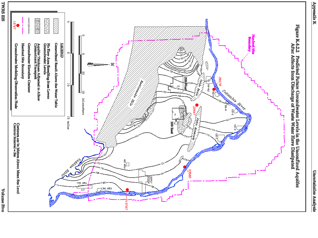
The appropriateness of the December 1979 groundwater level data as a basis for impact analysis was tested in two ways: 1) qualitatively, by comparing the December 1979 groundwater level surface with predicted Site groundwater levels prior to Site development (i.e. hindcast) and 2) quantitatively, by calculating future Site groundwater levels using the VAM2D model and the same assumptions of boundary conditions and infiltration as used for the impact analysis, except that there was no water inflow from Site wastewater disposal to the vadose zone. Contaminant concentrations and associated risks were predicted for the Ex Situ Intermediate Separations alternative using this "no mound" predicted future flow field.
The differences among the December 1979 groundwater levels as simulated by the CFEST model (Volume Four, Figure F.2.4.2), the interpolated and contoured groundwater levels based on individual groundwater levels measured in site monitoring in December 1979, and the December 1979 groundwater levels as simulated by the VAM2D model were insignificant. The inferred groundwater flow directions in the hindcast (Figure K.4.2.1) were similar to the December 1979 simulated groundwater levels (Volume Four, Figure F.4.3.1). Groundwater flow directions inferred in the December 1979 representation were generally southeast/east, with a small component flowing northeast through the gap between Gable Butte and Gable Mountain. Groundwater flow directions inferred in the hindcast were due east, with a slight component of flow to the southeast and a slight component flowing northeast through the gap between Gable Butte and Gable Mountain.
The appropriateness of the December 1979 groundwater levels as a basis for impact analysis was examined quantitatively by predicting future groundwater levels assuming no impacts (e.g., groundwater mounds) from Site wastewater disposal and analyzing the associated risks for the Ex Situ Intermediate Separations alternative. Future groundwater levels were predicted by a steady-state simulation of the groundwater flow system assuming no inflow from Site wastewater discharges. These wastewater discharges were active in December 1979 and their estimated flow rates are provided in Volume Four, Table F.2.4.1. All the sites listed in this table, except the Rattlesnake Mountain Springs site, are waste disposal sites. The predicted future groundwater levels for these assumed conditions are provided in Figure K.4.2.2.
The future predicted groundwater levels, the December 1979 groundwater representation, and the hindcast all were very similar. As expected, the groundwater mounds from U Pond and B Pond evident in the December 1979 groundwater levels are not evident in Figure K.4.2.2. Recharge on the western portion of the Site from the valley out of the Rattlesnake Hills, coupled with the relatively low hydraulic conductivity of the sediments west of the 200 West Area, resulted in a relatively large groundwater gradient as indicated by the close contour spacing in that area. The gradient magnitude and direction in the area midway between 200 West and 200 East to the Columbia River on the east side of the Site were similar to the hindcast, which indicated a primary easterly flow direction from the 200 Areas.
The dissipation of the groundwater mounds, which would occur when the wastewater discharge was terminated, and the overall groundwater level drop, resulted in a larger area of Gable Mountain extending above the groundwater table. This difference in the Gable Mountain area above the groundwater table for the December 1979 groundwater levels and the forecasted "no mound" groundwater levels is illustrated in Figure K.4.2.2. This resulted in a slightly smaller aquifer area in which contaminants released from the waste tanks would dilute. The change would tend to prevent contaminants from diluting as quickly in the area immediately east of the 200 East Area, compared to the prediction based on the December 1979 groundwater levels. The larger Gable Mountain area above the groundwater table was predicted to extend to the northern portion of the 200 East Area, including the area around waste tank source area 1ESS. For comparison purposes, the aquifer in this area (Figure K.4.2.2) was assumed to be thicker by approximately 1 to 3 m (3 to 10 ft). This was necessary to simulate the transport of contaminants from the 1ESS source area through the aquifer. This adjustment to aquifer thickness may have artificially resulted in higher contaminant concentrations in the area near 1ESS.
Figure K.4.2.1 Hindcast of Water Levels in the Unconfined Aquifer
Section K.7.5 compares the calculated risks for the Ex Situ Intermediate Separations alternative based on December 1979 groundwater levels with those based on the predicted future groundwater levels shown in Figure K.4.2.2.
Climate Change
A climate change scenario was examined that included the return of an ice age. At present, the earth is in an interglacial phase. A transition to a glacial climate during the next few thousand years is highly unlikely. Such a transition during the next 10,000 years is more probable. Over a million-year time scale the global climate is virtually certain to pass through several glacial-interglacial cycles (National Research Council 1995).
Three potential changes associated with an ice age would likely impact waste disposed of onsite. These include 1) a cooler, wetter climate during early and late phases of the ice age that would increase infiltration through the waste and cause a faster movement of contaminants from onsite disposal locations to the Columbia River; 2) a cold, dry climate during the middle phase of the ice age that would reduce infiltration through the waste and slow migration of waste to the Columbia River; and 3) a catastrophic flood that would reach the Central Plateau and dislodge and scatter waste from the disposal site. During previous ice ages, ice dams have formed on upper tributaries of the Columbia River. These dams, when broken through, have resulted in floods of up to 2E+06 m3 (5E+08 gal) of water in a period of a few weeks compared to the present average flow of the Columbia River of about 1E+05 m3/year (3E+07 gal/year). Such floods would be likely to impact any waste disposed of near the surface on the Hanford Site, scouring out waste sites to a depth of several meters and then redepositing waste from the tanks throughout the Pasco Basin.
Radioactive decay would have reduced the hazard from wastes disposed of onsite under all of the alternatives by the time of the postulated glacial flood in the next 40,000 to 50,000 years. For all of the alternatives, peak impacts on groundwater beneath the 200 Areas would have occurred at 210 to 350 years from the present for the No Action and Long-Term Management alternatives for Kd=0 and at 3,600 to 8,900 years from the present for all other alternatives. Because of the low concentrations of Pu and other radionuclides that would remain at the time of the postulated flood, the radiological consequences of a glacial flood would be small in comparison to the effects of the flood itself (DOE 1987).
One-Dimensional Flow
Two-dimensional or three-dimensional simulations of contaminant flow and transport in the vadose zone could provide more accurate estimates of contaminant arrival time, peak time, and peak concentrations (compared to one-dimensional simulations), provided that the spatial vadose zone hydraulic and transport properties were known. However, adequate knowledge of these parameters for two- or three-dimensional modeling currently is not available.
The one-dimensional simulations provided for this assessment were conservative and resulted in comparable estimates for each alternative. The simulations were conservative compared to two- or three-dimensional simulations using the same vadose zone properties. Because two- or three-dimensional flow and transport simulations allow for lateral flow and transport (slowing vertical movement), the transport times for the one-dimensional simulations were as fast or faster and the peak concentrations were higher because all transport and flow were in one direction only: downward within a uniformly porous medium.
Contaminants were assumed to move downward by advection with infiltration from precipitation and dissolution and leaching from tanks. The flow of water and transport of contaminants in the vadose zone would principally be in the vertical direction because of the hydraulic gradient and geologic structure (layering) in the vadose zone, which was assumed insufficient to result in extensive lateral spreading. Therefore, only one-dimensional modeling was performed in the vadose zone assuming a uniformly porous media and uniform hydraulic gradient.
Releases to the Soil During Retrieval
The ex situ alternatives were all assumed to result in contaminant releases from SSTs during retrieval operations. Each SST was conservatively assumed to lose 15,000 L (4,000 gal) during retrieval for a total of 2E+06 L (6E+05 gal) from the 149 SSTs. This assumption was based on current information from the waste retrieval program and the assumption that the average leakage volume from an SST would be one order of magnitude lower than the maximum release volume estimated for tank 241-C-106 during sluicing operations (DOE 1995d).
Based on the nominal retrieval scenario, all of the ex situ alternatives would have a contaminant first arrival time at the vadose zone/groundwater interface of approximately 1,000 years because of losses during retrieval. The lower bounding retrieval scenario would not change the time of release, and the contaminant first arrival time would not be expected to change either.
The rising limb of the concentration versus time curves at the vadose zone/groundwater interface (see Volume Four, Figure F.3.5.1 for characteristics of the ex situ alternatives) would shift to the right and calculated peak concentrations would be lower and could occur slightly later. Even though retrieval releases occur early compared to residual releases, the maximum peaks for the lower bounding scenario could be somewhat lower because the total mass released would be lower.
The following general alternative-specific assumptions were made for the modeling effort.
General Assumptions
- For the radioactive contaminants, the mass was estimated for each isotope based on the decay of that isotope to December 31, 1995.
- Some contaminants in the tank inventory are of little importance and were not considered further in the groundwater assessment (Volume Four, Table F.2.2.3 provides a list of these contaminants).
- Contaminants were assumed to be released by their desorption and dissolution into pore fluids (this assumption holds for tank saltcake/sludge (No Action), grouted, and vitrified waste forms) and then moved by advection and diffusion from the waste source into the surrounding natural material or engineered barrier. Contaminants that are insoluble were assumed not to leach to groundwater.
- The LAW disposal facility was considered one source area even though 41 vaults are anticipated. The vaults would be covered with a continuous Hanford Barrier and the contents of each vault were assumed similar.
- The 177 tanks were divided into eight source areas based on configuration, tank proximity, and groundwater flow direction.
- Ingrowth of decay products was not calculated.
- No preferential flow paths (e.g., macropore flow) exist in the vadose zone.
- No Action (Tank Waste) and Long-Term Management alternatives assumptions included the following.
- Releases to the groundwater system were associated with the complete inventory of contaminants in the waste tanks (Volume Four, Table F.2.2.2) except for insoluble contaminants.
- Infiltration would be 5 cm/year (2 in./year) initially and throughout the period of interest.
- Contaminant releases for the five SST source areas were assumed to begin at the end of institutional control.
- Contaminant releases from the three DST source areas were assumed to begin 100 years after the end of institutional control.
- The duration of this release was based on a congruent dissolution model. In this model, all constituents in the waste inventory were assumed to be released in proportion to the most abundant material in the waste inventory, nitrate. The concentration of nitrate is 360 g/L (Serne-Wood 1990). The initial unit concentration assumed in modeling for Kd groups 1 and 2 (Kd equals zero and one) was 400 g/L. The only difference between these alternatives is that under the Long-Term Management alternative, DSTs would be replaced during the institutional control period and assumed to begin leaking 100 years after the institutional control.
- In Situ Fill and Cap alternative assumptions included the following.
- Releases to the groundwater system were associated with the complete inventory of contaminants in the waste tanks (Volume Four, Table F.2.2.2).
- The initial vadose zone flow field was based on an infiltration rate of 5 cm/year (2 in./year).
- In 1997, the infiltration rate was assumed to decrease to 0.5 cm/year (0.2 in./year) in response to Hanford Site activities and decrease again to 0.05 cm/year (0.02 in./year) after the Hanford Barrier was installed. The Hanford Barrier was assumed to have lost integrity 1,000 years after installation, which would cause infiltration to increase to 0.1 cm/year (0.04 in./year) throughout the remainder of the 10,000-year period of interest.
- Five hundred years after the Hanford Barrier was installed, contaminant releases for the eight tank source areas were assumed to begin (NRC 1994).
- The principal constituent of the waste would be nitrate and the congruent dissolution release model was used to estimate release from the waste, which was the same approach as described for the No Action and Long-Term Management alternatives. The dissolution concentration of nitrate was assumed to remain constant at 360 g/L (Serne-Wood 1990), regardless of the water flux. The initial unit concentration assumed in modeling was 400 g/L.
- The initial contaminant inventory and concentrations were the same as for the No Action and Long-Term Management alternatives.
- In Situ Vitrification alternative assumptions included the following.
- Releases to the groundwater system were associated with the contaminants in the waste tanks, but the vitrification process would result in a different waste form (Volume Four, Table F.2.2.4).
- The initial vadose zone flow field was based on an infiltration rate of 5 cm/year (2 in./year).
- The infiltration rate was assumed to decrease to 0.05 cm/year (0.02 in./year) after the Hanford Barrier was installed. The Hanford Barrier was assumed to lose integrity 1,000 years after installation, which would cause infiltration to increase to 0.1 cm/year (0.04 in./year) throughout the remainder of the 10,000-year period of interest.
- Five hundred years after the Hanford Barrier was installed, contaminant releases for the eight tank source areas were assumed to begin (NRC 1994).
- The release model for the vitrified mass was based on a constant total mass loss rate of 1.0E-03 g/m2 per day (Shade et al. 1995). The mass loss rate was independent of the water flux from recharge. The composition of the vitrified mass was assumed to be identical to the soda-lime glass formed in the Ex Situ No Separations alternative (WHC 1995c). The release concentration of contaminants was then assumed to be proportional to their concentration in the soda-lime glass. Because the total mass loss rate would be constant, the composition of the released solution would be unaffected by the recharge rate. Because the infiltration rate would double after the barrier lost integrity, the mass flux would increase proportionately. The low value of the total mass loss rate, combined with the very large quantity of vitrified mass, would result in a release time measured in millions of years.
- Ex Situ Intermediate Separations alternative assumptions included the following.
- Releases to the groundwater system were associated with 1) releases during retrieval from the SSTs; 2) releases from residuals that could not be removed from the waste tanks; and 3) releases from the LAW disposal facility.
- The amount of liquid released from each SST during retrieval operations would be 15,000 L (4,000 gal). The mass associated with retrieval operations at each source area is provided in Volume Four, Table F.2.2.5.
- The tank residual materials were assumed to be 1 percent of those for the No Action and Long-Term Management alternatives (Volume Two, Appendix A).
- The mass associated with the contaminants in the LAW vaults was based on the vitrified form of the retrieved waste (Volume Four, Table F.2.2.6).
- The initial vadose zone flow field was based on an infiltration rate of 5 cm/year (2 in./year) for tank source areas and the LAW source area.
- In 1997 the infiltration rate was assumed to decrease to 0.5 cm/year (0.02 in./year) in response to Site activities and decrease again to 0.05 cm/year (0.02 in./year) after the Hanford Barrier was installed at tank source areas and the LAW source area. The Hanford Barrier was assumed to lose integrity 1,000 years after installation, which would cause infiltration to increase to 0.1 cm/year (0.04 in./year).
- Contaminant releases for the five SST source areas were assumed to occur 1) during retrieval in 1997; and 2) from residual materials 500 years after Hanford Barrier construction.
- Contaminant releases for the three DST source areas were assumed to result from releases from residual materials 500 years after Hanford Barrier construction.
- Contaminant releases for the LAW facility were assumed to begin 500 years after the Hanford Barrier was constructed over the vaults (NRC 1994).
- The solubility of each contaminant for retrieval releases and tank residuals would be proportional to the solubility of nitrate. For the tank source areas, the initial unit concentration assumed in modeling was 400 g/L.
- The release model for the glass cullet was based on a constant corrosion rate of 3E-06 cm/year (1E-06 in./year) (Jacobs 1996). This corrosion rate would be independent of the water flux from infiltration. The composition of the LAW glass was taken from the engineering data package for this alternative (WHC 1995j). The release concentration of the contaminants was assumed to be proportional to their concentration in the LAW glass. Because the total mass loss rate would be constant, the composition of the released solution would be unaffected by the infiltration rate. Because the infiltration rate would double after the barrier lost integrity, the mass flux would increase proportionately. The low value of the corrosion rate, combined with the large quantity of vitrified mass, would result in a calculated release time of 170,000 years.
- For the tank source areas, the initial contaminant concentrations were the same as for the No Action and Long-Term Management alternatives. The initial concentrations for the LAW disposal facility are provided in Volume Four, Table F.2.2.17.
- Ex Situ No Separations alternative assumptions included the following.
The assumptions for this alternative were the same as for the tank retrieval and tank residual components of the Ex Situ Intermediate Separations alternative (i.e., 1 percent of tank waste was assumed to remain as a residual in the tanks).
- Ex Situ Extensive Separations alternative assumptions included the following.
The assumptions for this alternative were the same as for the tank retrieval and tank residual components of the Ex Situ Intermediate Separations alternative (i.e., 1 percent of tank waste was assumed to remain as a residual in the tanks). For this alternative, the contaminant inventory in the LAW vaults would be smaller than estimated for the LAW vault component of the Ex Situ Intermediate Separations alternative (see Volume Four, Table F.2.2.7).
- Ex Situ/In Situ Combinations 1 and 2 alternatives assumptions included the following.
These alternatives would incorporate all of the assumptions listed for the Ex Situ Intermediate Separations alternative and the In Situ Fill and Cap alternative except as noted as follows. For the tanks remediated ex situ:
- Releases to the groundwater system would be due to losses during retrieval (Volume Four, Table F.2.2.8).
- Residual waste that could be left in a tank after retrieval was assumed to be 1 percent of the initial tank inventory.
- The 1 percent residual waste was added to the inventory of tanks remediated in situ.
For the tanks remediated in situ:
- Releases to the groundwater system would be due to leaching from the waste form within the tanks (Volume Four, Table F.2.2.9). Table F.2.2.9 contains the initial waste inventory.
- Phased Implementation alternative assumptions included the following.
- There would be no groundwater impacts associated with the first phase of this alternative because there would be no contaminant releases from the tanks.
- The assumptions for the total alternative would be the same as those for the Ex Situ Intermediate Separations alternative.
K.4.2.2 Parameter Sensitivity
Parameter sensitivity was investigated for the following areas:
- The effect of higher glass surface areas for the In Situ Vitrification alternative;
- The effect of changing the performance period of the Hanford Barrier from 1,000 to 500 years;
- The effect of the decay of the potentiometric head from groundwater mounding due to discharge to the Hanford Site ponds;
- The effect of variations in infiltration rate; and
- The effect of variations in distribution coefficient (Kd).
In Situ Vitrification Surface Area
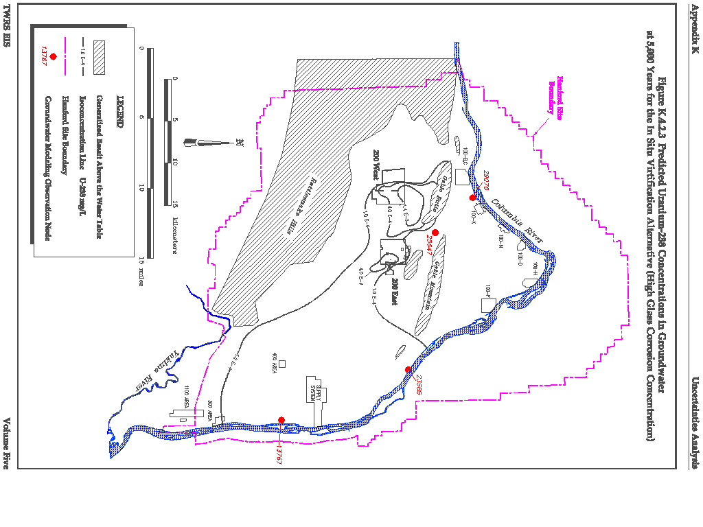
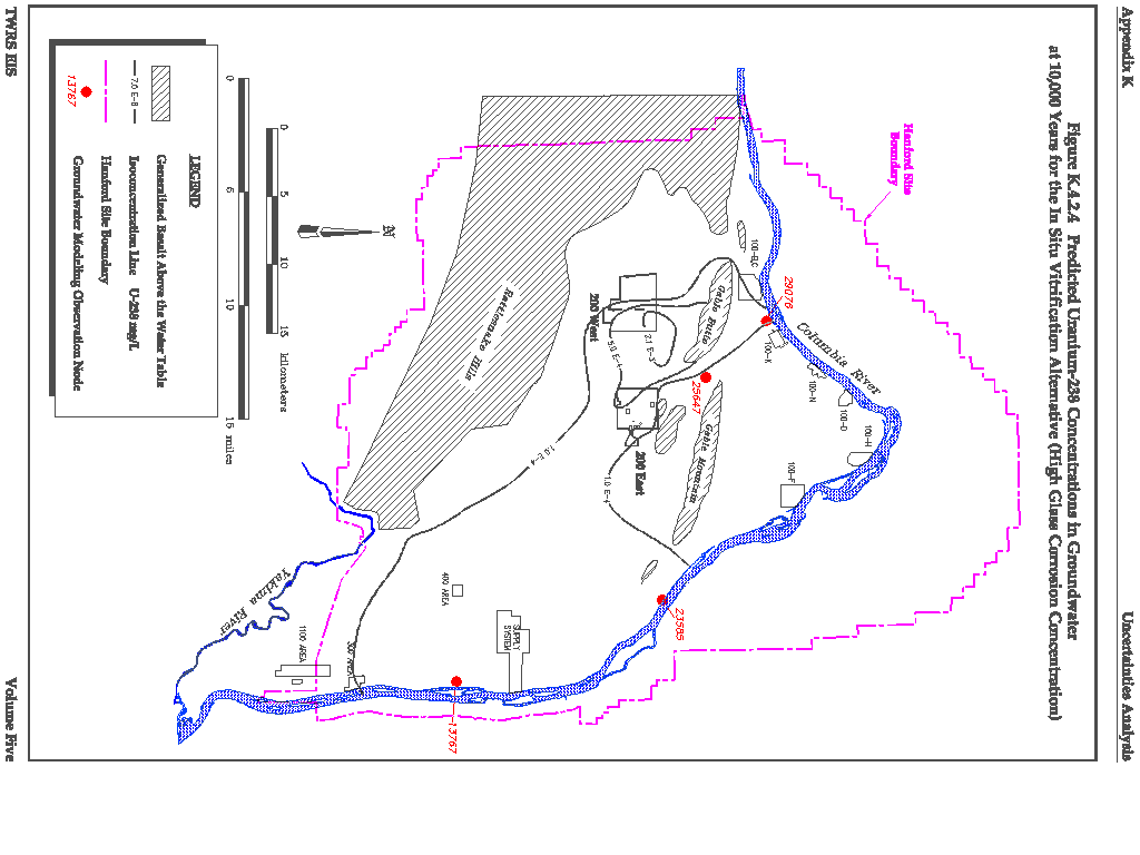
As part of the parameter sensitivity analysis, the vitrified glass surface area was assumed to have doubled to represent the case where extensive cracking of the waste form occurred. This higher surface area doubled the corrosion rate. The predicted U-238 concentrations in groundwater at 5,000 and 10,000 years, respectively, at the higher corrosion rate are provided in Figures K.4.2.3 and K.4.2.4. Comparing these figures with Volume Four, Figures F.4.3.4 and F.3.4.5, which were based on the original corrosion rate, shows that the estimated contaminant concentrations in groundwater at the higher surface area are almost indistinguishable from those calculated for the base case analysis.
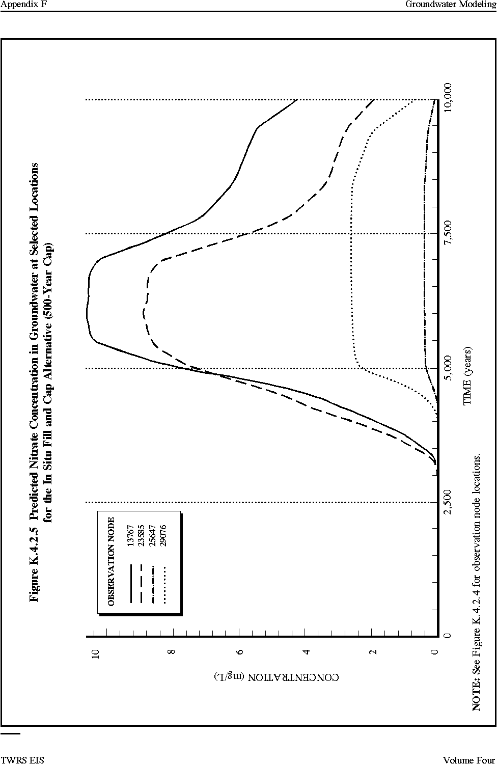
500-Year versus 1,000-Year Hanford Barrier
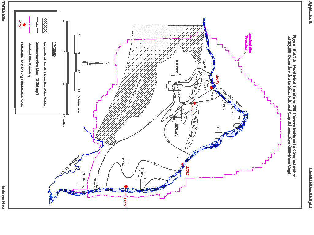
There is some uncertainty concerning the long-term performance of the Hanford Barrier that would be placed over the tanks and the LAW vaults. This uncertainty was investigated using the In Situ Fill and Cap alternative as a basis for comparison. The Hanford Barrier was assumed to degrade 500 years after placement instead of after 1,000 years as assumed in Volume Four, Section F.3.3. At 500 years, the water flux through the Hanford Barrier was assumed to double from 0.05 to 0.1 cm/year (0.02 to 0.04 in./year). The calculated nitrate concentration at selected locations within the unconfined aquifer is provided in Figure K.4.2.5. Comparing Figure K.4.2.5 with Volume Four, Figure F.3.3.3 shows no significant difference in peak concentrations of nitrate, the most abundant and mobile contaminant. The time of arrival of contaminants (using nitrate as an example) is slightly earlier for the 500-year Hanford Barrier. A comparison of Figures K.4.2.6 and Volume Four, Figure F.3.3.16 indicates that U-238 concentrations in groundwater at 10,000 years from the present are low for both cases, and for the 500-year Hanford Barrier, U-238 concentrations are lower by a factor of approximately 5 to 10. This occurs because the higher water flux through the 500-year Hanford Barrier would allow U-238 to travel faster through the vadose zone and the groundwater system.
Variations in Infiltration Rate
An infiltration rate of 5 cm/year (2 in./year) was assumed as the initial condition for all the alternatives. For those alternatives involving active remediation, such as the In Situ Vitrification and Ex Situ Intermediate Separations alternatives, the infiltration rate was assumed to be reduced to 0.5 cm/year (0.2 in./year) during the remediation period (e.g., during waste removal and cap construction).
The assumed infiltration rate of 5 cm/year (2 in./year) is an appropriate value that is within the range of reported values. Prior to Site development in the early 1940's, the infiltration rate was likely much lower, on the order of a few millimeters per year, characteristic of the 200 Areas Plateau under naturally vegetated conditions. As the tank farms were constructed, the natural vegetation was removed and the vicinity around the tanks was covered with sand and gravel. The current infiltration rate in the vicinity of the tanks is believed to be on the order of 10 cm/year (4 in./year). This higher infiltration rate would be greatly reduced with the installation of a cap or return to natural shrub-steppe type ground cover.
To estimate the sensitivity of the overall results (e.g., concentration of tank wastes predicted in groundwater) to the initial infiltration rate of 5 cm/year (2 in./year), an alternative infiltration scenario was developed for the In Situ Fill and Cap alternative. For this scenario, the initial infiltration rate was assumed to be 1 cm/year (0.4 in./year) for the 200 Areas Plateau under natural vegetation. It was assumed that in 1955, the infiltration rate increased to 10 cm/year (4 in./year) and would remain at this rate until 2023, after the cap construction was complete for all source areas. At this time, the infiltration rate would be reduced to 0.05 cm/year (0.02 in./year) and would remain at this level for 1,000 years. All other aspects of the In Situ Fill and Cap alternative are the same as assumed in Volume Four, Section F.2.2.3.3. Contaminant flow and transport through the vadose zone were simulated using this infiltration scenario for three of the eight source areas. The source areas and their total vadose zone thicknesses (from the base of the tanks to the water table) are as follows:
| Source Area | Vadose Zone Thickness
m (ft) |
| 1WSS | 51 (170) |
| 2WSS | 48 (160) |
| 5EDS | 68 (220) |
These source areas were chosen because they bound the range of vadose zone thicknesses. When the results of this alternative infiltration scenario, graphed as concentration versus time, were compared to the nominal case (i.e., initial infiltration rate of 5 cm/year [2 in./year]), they were nearly identical, with less than a 1 percent difference between estimated concentrations.
Variations in Distribution Coefficients
As explained in earlier sections, the distribution coefficient (Kd) for a specific contaminant is an indication of the mobility of the contaminant within the aquifer system. Contaminants with lower Kds are more mobile, and contaminants with higher Kds are less mobile. Contaminants with Kds of 0 and 1 mL/g have been calculated to arrive at the interface between the vadose zone and groundwater within the 10,000-year period of interest for both the No Action and Long-Term Management alternatives. For the other alternatives, only contaminants in Kd Group 1 (Kd equal to 0) have been calculated to arrive at the vadose zone groundwater interface within 10,000 years because the influx of precipitation into the waste would be greatly reduced by the cap. Not all the contaminants in Kd Group 1 have a Kd of zero. Uranium is an example of a contaminant that, while conservatively placed in Kd Group 1, likely has a Kd between zero and one. The Ex Situ Intermediate Separations alternative was selected as representative of alternatives that incorporate a cap and was used as the basis for estimating the sensitivity of contaminant transport for Kd values between zero and one.
The sensitivity of contaminant travel time through the vadose zone to various Kd values was evaluated by varying Kd for this alternative and for the 1WSS source area and then tabulating the arrival time at the vadose zone/groundwater interface. The range of Kd values selected for analysis and the times of first arrivals calculated by the model is as follows:
| Kd Value
(mL/g) |
First Arrival at Vadose Zone/
Groundwater Interface (years) |
| 0.00 | 1,500 |
| 0.05 | 5,300 |
| 0.075 | 7,000 |
| 0.10 | 8,600 |
| 0.125 | 10,000 |
For Kd greater than 0.125 mL/g, first arrival did not occur until just after 10,000 years. This is important for contaminants such as U that are reported to have Kd values of approximately 0.6 mL/g at the Hanford Site, as they would not reach the groundwater within the period of interest for alternatives that include a cap.
K.4.3 TRANSPORT IN SURFACE WATER
The primary sources of uncertainty in estimating surface water transport are associated with the rate of dilution of contaminants in groundwater entering the Columbia River. These sources are the turbulence of river flow, which depends on the velocity; irregularities in the stream channel, including bends; and the width of the river. All these factors ultimately depend on the total flow in the river at the point(s) where contaminated groundwater would be discharged.
K.4.4 TRANSPORT IN AIR
Various assumptions and other factors can introduce uncertainty into air dispersion modeling studies. With regard to the modeling performed to analyze air impacts from the various EIS alternatives, these uncertainties can be separated broadly into the following categories:
- Uncertainty inherent in the air dispersion models;
- Uncertainty in data used as model inputs; and
- Uncertainty in interpretation of model output.
These categories are discussed in more detail in the following text.
K.4.4.1 Air Dispersion Modeling
Air dispersion models are mathematical tools designed to estimate pollutant concentration and/or deposition at specific locations. These predictions are based on various input parameters and physical assumptions, such as the following:
- Pollutant release characteristics (emission rate, temperature, flow rate);
- Meteorological conditions (ambient temperature, mixing height, stability, wind speed and direction, atmospheric temperature, and wind speed profile); and
- Pollutant transport behavior (dispersion, plume rise, interaction with terrain).
In an ideal case, the values entered into the model for these known parameters will closely duplicate the range of conditions that exist for a particular scenario. However, the stochastic nature of the atmosphere results in other unknown factors (e.g., wind perturbations) that influence the dispersion at a particular time or place. It has been estimated that even when the known conditions are exactly duplicated in the model, the unknown factors can contribute to variations in concentration as much as ±50 percent.
Gaussian air dispersion models are accurate within a factor of two when properly executed with accurate data. In general, models are more reliable when estimating long-term average concentrations as opposed to short-term averages, and are reasonably reliable in estimating the highest concentration occurring, but are not capable of predicting the exact time or position of the occurrence. In other words, the highest concentration that can be expected in an area can be predicted with reasonable accuracy; the location and time that the maximum concentration will occur are less reliably predicted.
The air dispersion models used in this study are considered to be state-of the-art for regulatory modeling and are recommended by the U.S. Environmental Protection Agency (EPA) for this type of analysis. To compensate for the uncertainties in model results, conservative input values were used that provide conservative (higher than might occur under average conditions) results.
K.4.4.2 Model Input Data
Two types of input data were used for the air dispersion models: meteorological data and source data. Both types of input data are discussed in the following text.
Meteorological Data
Two types of meteorological data (i.e., long-term and short-term) were used in the dispersion modeling study. Long-term (i.e., annual) average concentrations were estimated using meteorological data collected at the Hanford Meteorological Station from 1989 to 1993. The assumption inherent in this choice is that these data represent future meteorological conditions. A 5-year record is generally accepted as an adequate sample set for modeling purposes. Although long-term climatic shifts may occur, many of the air pollutant emitting activities analyzed in this study are expected to occur within several decades of project initiation, which is a relatively short time frame on a climatic scale. Therefore, the use of these data is not expected to adversely affect the results.
Typically, short-term average (i.e., 1- 3- 8- and 24-hour) concentrations are predicted using hourly meteorological measurements from a station located at or near the site of interest. Because appropriate data were not available for this study, a screening approach was taken, and a standard set of hourly meteorological conditions were incorporated in the modeling. These standard conditions are accepted by the EPA to encompass the range of atmospheric stabilities and wind speeds that could be expected to occur anywhere. Each combination of wind speed and atmospheric stability was assumed to occur in every possible wind direction. The predicted concentrations represent the highest value that could reasonably be expected to occur anywhere. This approach is conservative because the meteorological conditions leading to the reported result may not occur at the site for all wind directions.
Source Data
Data describing the location, emission rate, and emission characteristics of the sources were input to the models. Information concerning pollutant emission rates was derived from data packages supplied by the Site Management and Operations contractor and analyzed by the EIS contractor. In general, conservative values were used to develop emissions estimates.
The location of the pollutant emitting sources was not known with complete certainty in all cases. Pollutant emitting activities associated with the existing tank farms will occur in the present locations. However, the exact location of future facilities is subject to some uncertainty. In general, the closer a source to a receptor, the higher the predicted concentration at that receptor. As a consequence, if the eventual location of an emitting activity is closer to a plant boundary than depicted in the model, the impacts may be higher. Of course, if the activity is located farther from the boundary than depicted in the model, the impacts may be lower.
The temporal arrangement of the pollutant emitting activities affects the predicted concentrations as well. The predicted concentration at any receptor includes the contributions from each individual emitting source. To properly analyze a scenario, all the pollutant emitting activities that could occur at the same time must be considered. In general, most of the scenarios analyzed involved a period of facility construction followed by an operational period.
In some cases, an emitting source is expected to move from place to place as the project progresses. An example of this would be emissions related to remedial activities at tank farm locations. In most cases at a given time, work would be occurring at one or two of the possible 17 locations. Given these uncertainties, a conservative analysis was ensured by assuming that activities that may or may not overlap would occur simultaneously. In addition, activities that are expected to move from place to place were modeled as if occurring in the location producing the highest potential impact.
Sources were modeled as either point or area sources. Point sources were used to approximate pollutant releases from a stack or other fixed, functional opening, or vent. The dispersion algorithms used for point sources modify the effective release height to take into account plume buoyancy (from a heated release) and momentum (from vertical release velocity). Typically, area sources were used to approximate pollutant releases that would not occur at a single, well-defined point, but instead can be defined as occurring within a defined area. For instance, an area source could include many small fixed point sources that were too numerous to model individually, or could be made up of several mobile sources that could move about within the fixed area. In this study, the construction activities were represented as area sources. The classification of the sources into these two categories involved some degree of uncertainty as well as some assumptions. The models used different algorithms to represent dispersion from point and area sources, and the predicted concentration at a receptor could vary depending on the algorithm chosen. In general, these effects would be more noticeable at locations close to the source and tend to diminish as the distance between source and receptor increased.
K.4.4.3 Interpretation of Model Output
The short-term model was run using screening meteorology to produce predicted maximum 1-hour average concentrations. These 1-hour average values were converted to 3- ,8-, and 24-hour average concentrations, when appropriate, to compare to applicable standards. This was accomplished by applying conversion factors to the 1-hour average values. Consistent with modeling guidelines (EPA 1988), the factors of 0.9, 0.7, and 0.4 were applied to convert to 3-, 8-, and 24-hour averages, respectively. These factors involve an implied assumption regarding the persistence of the meteorological condition producing the highest 1-hour impact. In other words, conservative meteorological conditions that produced the highest 1-hour concentration can be expected to persist for most of a 3-hour period, and to a lesser degree over an 8- or 24-hour period. The modeling guidelines indicate a range of values for each conversion factor: the 3-hour conversion factor can range from 0.8 to 1.0, the 8-hour factor from 0.5 to 0.9, and the 24-hour factor from 0.2 to 0.6. Use of the midpoint values was considered appropriate for this study.
Chronic (Routine) Air Dispersion
In the routine risk assessment, the airborne transport is based on the 9-year average (1983 to 1990) wind data measured at 10 m (33 ft) and 61 m (200 ft) at the Hanford Meteorological Station (HMS) in the 200 Areas. The variation in the chronic atmospheric dispersion coefficient (Chi/Q) was estimated using wind data collected at 10 m (33 ft). The values for joint frequency were computed by GXQ Version 4 (Hey 1993 and 1994).
The locations of the onsite maximum individuals were taken to be 100 m (330 ft) from the release point for ground level releases, and 800 m (2,640 ft) for stack releases. The locations of the site boundary maximum individuals were averages of the distances from the Plutonium Finishing Plant (PFP) and the Plutonium-Uranium Extraction (PUREX) Plant. These distances are shown in Table K.4.4.1.
The maximum normalized time-integrated exposures (Chi/Q) for each year estimated with available data are listed in Table K.4.4.2. The observed variation in the annual Chi/Q at the chosen locations is approximately a factor of 2. Population weighted Chi/Q values are subject to similar variation. The observed variation in population-weighted Chi/Q values is less than a factor of 2 (Table K.4.4.3).
Acute (Accident) Air Dispersion
Bounding Chi/Q values were generated consistent with the methods described in Nuclear Regulatory Commission (NRC) Regulatory Guide 1.145 (NRC 1982). The Chi/Q values were calculated assuming the receptor was located at the peak concentration. Because atmospheric conditions fluctuate, a bounding atmospheric condition was considered to be that which causes a downwind concentration of airborne contaminants that is exceeded for only a small fraction of time due to weather fluctuations. Regulatory Guide 1.145 defines this fraction as 0.5 percent for each sector or 5 percent for the overall site. The site is broken up into 16 sectors, which represent 16 compass directions (e.g., S, SSW, SW, ESE, SE, SSE). Chi/Q values are generated for weather conditions that result in downwind concentrations that are exceeded only 0.5 percent of the time in the maximum sector, or 5 percent of the time for the overall site. These Chi/Q values also are referred to as 99.5 percent maximum sector or 95 percent overall site Chi/Q values. The greater of these is called the bounding Chi/Q value and was used to assess the bounding dose consequences for accident scenarios presented in this EIS (Table K.4.4.4). These bounding Chi/Q values represent minimum dispersing conditions that result in maximum downwind concentrations (i.e., concentrations that are exceeded only a small fraction of the time). These Chi/Qs will result in conservative estimates of potential accident consequences.
Table K.4.4.1 Site Boundary Distance from PFP and PUREX
Table K.4.4.2 Maximum Individual Annual Chi/Q for Selected Receptor Locations
Table K.4.4.3 Maximum Population - Weighted Annual Chi/Q for Selected Receptors Locations
Annual average Chi/Q values also were generated for each sector. The sector with the highest annual average Chi/Q value was selected as presented in Table K.4.4.5. These values were used in conjunction with nominal source terms to calculate nominal dose consequences. The annual average Chi/Q values were calculated assuming the receptor was located at the peak concentration. The dose calculated using the annual average Chi/Q value for a particular sector represented the average dose to an individual located in that sector, accounting for the frequency of time that the wind blew in that direction during the year. This, it accounted for the fact that the receptor in a particular direction would experience no dose if the wind was blowing in a different direction at the time of the accident, and would receive a dose higher or lower than the annual average if the wind was blowing in the direction of the receptor. In summary, the dose based on annual average meteorology represented the average that an individual in a particular sector would receive for all meteorological conditions over the year. The ratio between the bounding and the annual average meteorology is presented in Table K.4.4.6.
Table K.4.4.4 Bounding Meteorology Chi/Q Values Generated for Ground Level Releases from Tank Farms
|
NEWSLETTER
|
| Join the GlobalSecurity.org mailing list |
|
|
|