


APPENDIX H PREHISTORIC AND HISTORIC CULTURAL RESOURCES
H.1 INTRODUCTION
This appendix provides an evaluation of the prehistoric and historic cultural resources at the Lawrence Livermore National Laboratory (LLNL) Livermore site, LLNL Site 300, and Sandia National Laboratories, Livermore (SNL, Livermore). Prehistoric cultural resources refer to any material remains of items utilized or modified by people prior to the establishment of the Mission Dolores in San Francisco, the first San Francisco Bay Area mission, in 1776. These resources can include artifacts of stone, bone, shellfish, or wood. Physical alteration of the landscape that occurred during the prehistoric time, such as hunting blinds, remains of structures, excavated house pits, caches of artifacts, and concentrations of stones (such as cooking stones), are also considered prehistoric cultural resources. Historic cultural resources include all material remains from the time period subsequent to the establishment of Mission Dolores, including trash dumps; architectural features such as structures, foundations, basements, and wells; and any other physical alteration of the landscape, such as ponds, roads, landscaping and fences.
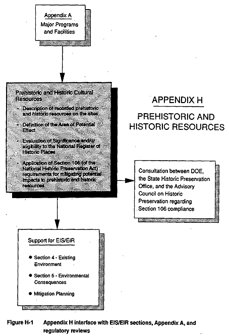
The relationship of this appendix to other appendices and to sections and requirements of the EIS/EIR, is shown in Figure H-1. Implementation of major programs and facilities described in Appendix A could affect potentially important cultural resources at the three sites. Evaluation of important cultural resources, and implementation of appropriate mitigation for impacts to these resources, will occur in compliance with the requirements of the National Historic Preservation Act.
Sections H.1.1 and H.1.2 of this appendix contain an overview of the federal and state regulatory requirements concerning cultural resources. Compliance with these requirements forms the basis of the project's mitigation of potential impacts to prehistoric and historic cultural resources. Section H.1.3 defines the Area of Potential Effect where impacts to cultural resources could occur as a result of the proposed action. Section H.2 includes a description of cultural resources (both prehistoric and historic) recorded at the three project sites and their potential importance under federal and state criteria for assessing significant cultural resources. In addition to a review of previous cultural resources investigations, an updated literature review and field investigations were conducted. Section H.3 identifies the necessary steps LLNL will undertake prior to approval of funding for proposed action construction projects to comply with Section 106 of the National Historic Preservation Act.
H.1.1 Federal Regulations Related to Cultural Resources
The National Historic Preservation Act was passed in 1966 to identify, record, and preserve significant prehistoric and historic properties. Section 106 of the National Historic Preservation Act (16 U.S.C. 470 et seq.) requires a federal agency (in this case, the U.S. Department of Energy) with jurisdiction over a proposed federal undertaking to take into account the effect of the agency's undertaking on properties included in or eligible for the National Register of Historic Places. Prior to approval of an undertaking, Section 106 also requires DOE to afford the Advisory Council on Historic Preservation a reasonable opportunity to comment on the undertaking. Section 110(f) of the National Historic Preservation Act (16 U.S.C. 470h-2) requires that federal agency heads, to the maximum extent possible, undertake such planning and actions as may be necessary to minimize harm to any National Historic Landmark that may be directly and adversely affected by an undertaking and, prior to approval of such undertaking, afford the Advisory Council on Historic Preservation a reasonable opportunity to comment. The process used by a federal agency to meet these responsibilities, is commonly called the Section 106 process.
The Advisory Council on Historic Preservation seeks through the Section 106 process to accommodate historic preservation concerns with the needs of federal undertakings. The Section 106 process is designed to identify potential conflicts between the two and to help resolve such conflicts in the public interest. The Advisory Council on Historic Preservation encourages this accommodation through consultation among the federal agency official (in this case, DOE), the State Historic Preservation Officer, and other interested persons during the early stages of project planning.
The State Historic Preservation Officer coordinates state participation in the implementation of the National Historic Preservation Act and is a key participant in the Section 106 process. The State Historic Preservation Officer reflects the interests of the state and its citizens in the preservation of their cultural heritage and will help DOE identify those persons interested in an undertaking and its effects on historic properties. It is also the role of the State Historic Preservation Officer to consult with and assist DOE in identifying historic properties, assessing effects on them, and considering alternatives to avoid or reduce those effects.
Section 106 of the National Historic Preservation Act specifies the following review process:
- Step one requires federal agencies (in this case, DOE) to identify and evaluate prehistoric and historic properties that may be affected by a project. For Section 106 review, properties are those that are eligible for, or listed on, the National Register of Historic Places, and may have significance at a national, state, or local level.
Properties to be considered include those that (1) are associated with the events that have made a significant contribution to the broad patterns of history; or (2) that are associated with the lives of persons significant in the past; or (3) that embody the distinctive characteristics of a type, period, method of construction, or that represent the work of a master, or that possess high artistic values, or that represent a significant distinguishable entity whose components may lack individual distinction; or (4) that have yielded, or may be likely to yield, information important in prehistory or history (36 C.F.R. section 60.4).
- Step two requires DOE, in consultation with the State Historic Preservation Officer, to determine what effect a project may have on historic properties.
- If the effect will be adverse, step three requires DOE to consult the relevant State Historic Preservation Officer (and, in many cases, the Advisory Council on Historic Preservation) to avoid, minimize, or mitigate the adverse effect.
- Step four requires the federal agency to provide the Advisory Council on Historic Preservation an opportunity to comment on the process, usually in the form of a review of the preceding steps and the subsequent execution of an agreement document.
In response to concerns on the part of the scientific community that efforts to preserve or protect historic scientific and technological resources through compliance with federal historic preservation law might impede efforts to remain at the forefront of international research and achievement, in 1989 Congress requested the Advisory Council on Historic Preservation to study the designation of scientific research institutions as historically significant. Concerns were raised by agencies faced with altering or renovating existing or abandoned research facilities which were considered eligible for the National Register by the Advisory Council on Historic Preservation. The resulting document, entitled "Balancing Historic Preservation with the Operations of Historic Technical or Scientific Facilities," discusses the needs of research institutions to upgrade their facilities and the responsibility of preservation agencies to implement the requirements of federal historic preservation regulations. LLNL and SNL, Livermore are "active," "pure," or "applied" research facilities carrying out "essential, often state-of-the-art, research and development" and as such are directly addressed by the report (Advisory Council on Historic Preservation, 1991).
The study concluded that Advisory Council regulations and the Section 106 review process are flexible enough to accommodate the legitimate needs of the scientific and engineering community and their activities at historic facilities. Among the recommendations outlined in the 1991 report are the following:
- Congress should reaffirm the national commitment to historic preservation by upholding the existing national historic preservation program and rejecting individual program or project requests for legislative waivers of historic preservation statutes.
- Future scientific achievement, as well as an adequate serving of the public interest, depends on an understanding of past scientific successes and failures. To the extent that they do not already, future authorizations for major scientific and technological programs should include public education components focusing in part on the communication of the relevant history of science.
- Decisions about projects that may affect historic properties need to be made with as complete an understanding as possible of such effects. However, considerations of preservation options should be kept distinct from the peer review process of awarding research grants and the determination of research priorities central to the scientific research process.
- The Advisory Council on Historic Preservation and affected federal agencies should jointly subscribe to a statement of policy that acknowledges the sensitive relationship between scientific research and the evolving history of science and its physical manifestations.
- Over the next two years, affected federal agencies, in cooperation with the Advisory Council on Historic Preservation, should examine current administrative procedures for historic preservation. This should include evaluating existing mechanisms for meeting responsibilities for National Historic Landmarks and other properties eligible for or listed on the National Register of Historic Places. As part of this process, affected federal agencies should determine how they might better coordinate historic preservation programs and planning among facilities managers, public affairs offices, archivists, historians, external affairs offices, and other staff. The Advisory Council should recommend measures to these agencies to improve the effectiveness, consistency, and coordination of those procedures with the purposes of the National Historic Preservation Act as prescribed by Section 202(a)(6).
- Innovative ways for minimizing and meeting the costs of historic preservation that may be associated with the operation and management of historic facilities must be explored by federal agencies, in cooperation with other concerned parties.
- The Advisory Council on Historic Preservation, in cooperation with the Smithsonian Institution and the National Park Service, should foster better communication between the preservation and museum communities and federal agencies, with the aim of establishing a consensus about what kinds of facilities and objects should be physically preserved for the future. This would include deciding how the historic value of facilities and objects should be determined, and which of these could be "preserved" through documentation. Most probably that option would be best suited to historic facilities that remain active today.
In conducting the historic evaluation of the LLNL Livermore site that is required to comply with the National Historic Preservation Act (presented later in this appendix), DOE will integrate recommendations from the 1991 Advisory Council on Historic Preservation publication.
A comprehensive discussion of the compliance process for both Section 106 and the California Environmental Quality Act (CEQA) (see section H.1.2) is presented by Busby and Garaventa (1990).
H.1.2 State Regulations Related to Cultural Resources
CEQA (California Resource Code, section 21083.2) requires the lead agency to determine whether a project may have a significant effect on prehistoric and historic cultural resources (referred to in CEQA as archaeological resources). Appendix K of the State CEQA Guidelines (California Office of Planning and Research, 1986) states that "public agencies should seek to avoid damaging effects on an archaeological resource whenever feasible. If avoidance is not feasible, the importance of the site shall be evaluated using the criteria outlined in Section III [of State CEQA Guidelines Appendix K]" (California Office of Planning and Research, 1986). Section III of CEQA Guidelines Appendix K states:
If the Lead Agency determines that a project may affect an archaeological resource, the agency shall determine whether the effect may be a significant effect on the environment. If the project may cause damage to an important archaeological resource, the project may have a significant effect on the environment. For the purposes of CEQA, an "important archaeological resource" is one which:
A. Is associated with an event or person of:
- Recognized significance in California or American history, or
- Recognized scientific importance in prehistory.
B. Can provide information which is both of demonstrable public interest and useful in addressing scientifically consequential and reasonable or archaeological research questions;
C. Has a special or particular quality such as oldest, best example, largest, or last surviving example of its kind;
D. Is at least 100 years old and possesses substantial stratigraphic integrity; or
E. Involves important research questions that historical research has shown can be answered only with archaeological methods.
With regard to determining the significance of cultural resources under CEQA, Appendix G in the State CEQA Guidelines states that "a project will normally have a significant effect on the environment if it will disrupt or adversely affect a prehistoric or historic archaeological site or a property of historic or cultural significance to a community or ethnic or social group" (California Office of Planning and Research, 1986).
In certain instances where federal- and state-related projects overlap, Section VI of the State CEQA Guidelines Appendix K states that "a public agency following the federal clearance process under the National Historic Preservation Act or the National Environmental Policy Act may use the documentation prepared under the federal guidelines in the place of documentation called for in this appendix" (California Office of Planning and Research, 1986).
H.1.3 Definition of the Area of Potential Effect
In the context of Section 106 of the National Historic Preservation Act, the Area of Potential Effect is the area in which planned development may directly or indirectly affect a cultural resource. Direct effects would include alteration of the surface by construction, while indirect effects would include human activity around the construction area. The Area of Potential Effect for each of the Laboratory sites is as follows:
LLNL Livermore Site
For purposes of this EIS/EIR, the Area of Potential Effect for prehistoric and historic cultural resources evaluation at the LLNL Livermore site is defined as the entire site.
LLNL Site 300
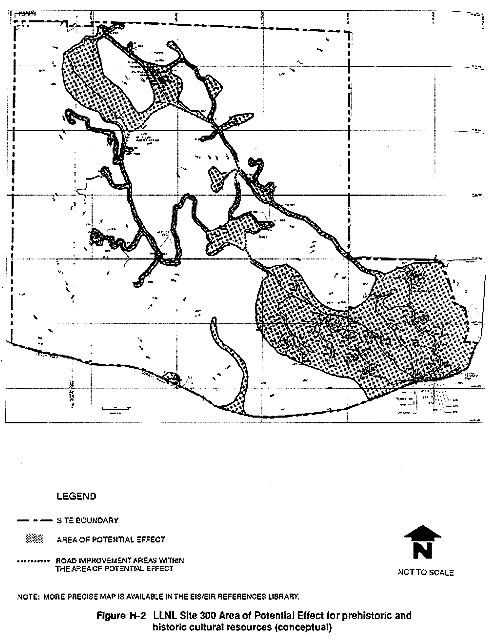
The Area of Potential Effect for LLNL Site 300 (for both prehistoric and historic cultural resources) is delineated on Figure H-2 and includes several discrete areas across the site. These areas represent areas of activity/disturbance anticipated in conjunction with the proposed action.
SNL, Livermore
The Area of Potential Effect for prehistoric and historic cultural resources at SNL, Livermore is defined as the entire site.
H.2 EXISTING SETTING AND REVIEW OF PREVIOUS INVESTIGATIONS
The following sections describe the current knowledge of prehistoric and historic cultural resources on the LLNL Livermore site, LLNL Site 300, and SNL, Livermore. These sections consider previously published investigations, archival research, and field verification of recorded resources.
H.2.1 Prehistoric Resources
The following brief overview of prehistoric resources in the vicinity of the Laboratories is derived from many sources and represents a consensus view of current knowledge. Additional information regarding the prehistoric settlement of the Livermore Valley and the vicinity of LLNL Site 300 is presented in the Basin Research Associates reports prepared for LLNL Site 300 and SNL, Livermore (Busby, Garaventa, and Kobori, 1981; Busby and Garaventa, 1990).
Native Americans are known to have inhabited Central California for the last 10,000 to 12,000 years, including the area in and around the LLNL Livermore site, LLNL Site 300, and SNL, Livermore. During that period, the amount and type of use of the land by Native American groups varied primarily due to environmental conditions, and also due to changes in cultural conditions. The remains and effects (archaeological sites) left from this human use vary as well (e.g., different amounts of faunal remains; different types of tools and other artifacts) which enables scientists to reconstruct both environmental changes and human cultural history.
The people who first inhabited Central California were most likely generalized hunter-gatherers spreading across the area, speaking a "Hokan" language, and having the ability to use a wide range of natural resources. The most ancient sites in the area reflect this type of economy. Later, perhaps 3000 to 5000 years ago, depending on location, the Hokan speakers were replaced by a physically and culturally distinct people who spoke "Penutian" languages. The Penutians seem to have perfected more specialized economies based on intensive use of specific abundant resources. These people are the ancestors of the Native Americans who inhabited Central California when the first Europeans arrived in the 1770s. The people in the San Francisco–Monterey Bay area at that time were called "Costaños" or coast-dwellers (Costanoans) by the Spanish, and are now perhaps better known as Ohlones. Native American Yokuts occupied the Central Valley, and the ranges of these two groups probably met somewhere in the vicinity of LLNL Site 300. Late prehistoric Indian tribelets in these areas had developed elaborate religious, cultural, economic, and social systems grounded in thousands of years of tradition.
Central California contains numerous prehistoric archaeological sites, many of which contain irreplaceable and valuable scientific information. The LLNL Livermore site, LLNL Site 300, and SNL, Livermore are perhaps not as relatively rich due to environmental factors (such as scarcity of food resources and other raw materials used as tools and ornamentation), but the area along the eastern slopes of the Diablo Range, which includes the area encompassed by LLNL Site 300, is poorly known due to lack of research. The scarcity of data for this area makes any archaeological data recovered relatively more important.
H.2.1.1 Resources at the LLNL Livermore Site
Information on prehistoric resources at the LLNL Livermore site is from an updated archival literature review conducted at the California Archaeological Inventory at Sonoma State University and at California State University Stanislaus; from records in the possession of Basin Research Associates, San Leandro, California; and from records on file at the LLNL Livermore site. These sources are cited in the text where appropriate. In addition, the results of field surveys conducted on May 16, 1991 and October 28, 1991 by Holman & Associates are presented.
Previous Prehistoric Resources Investigations
In 1974, a visual inspection of the LLNL Livermore site was completed, concentrating on areas where historic alteration of the ground was limited (Archaeological Consulting and Research Services, 1974). No surface indicators (i.e., artifacts or features found on the ground surface) of prehistoric resources were discovered. Approximately 35 acres were surveyed in 1982, including a short stretch of the small, intermittent Arroyo Seco at the southwest corner of the LLNL Livermore site and northward up Vasco Road to Mesquite Way, and no cultural (prehistoric or historic) resources were recorded (Busby, 1982). Woodruff (1990) evaluated two LLNL Livermore site properties, Building 310 on East Avenue and the Lighty property (Building 051) on Vasco Road, an area of less than two acres. Neither area was reported to contain significant cultural resources. A recent (1991) records search by Holman & Associates at the California Archaeological Inventory Northwest Information Center at Sonoma State University did not report any recorded sites or cultural resources on or near the LLNL Livermore site.
Field inspections for cultural resources in the western and northern perimeter areas surrounding the developed LLNL Livermore site were conducted on May 16 and October 28, 1991, by Holman & Associates. No prehistoric resources were discovered during the field inspection of the two perimeter areas.
The hot, flat valley floor environment and only intermittent sources of potable water in the immediate vicinity of the LLNL Livermore site made the property an unlikely location for prehistoric habitation, though the area has undoubtedly been used as a resource exploitation area. Rapid sedimentation since the advent of European culture in the region has very often obscured Livermore Valley floor prehistoric sites. The area with the greatest potential for harboring prehistoric materials is the southwest corner of the LLNL Livermore site, where the seasonal Arroyo Seco crossed the property prehistorically; however, previous surveys of the site have not located resources in this area.
H.2.1.2 Resources at LLNL Site 300
Previous Prehistoric Resources Investigations
LLNL Site 300 has been the subject of a Class III cultural resources inventory according to Bureau of Land Management standards (Busby, Garaventa, and Kobori, 1981). This inventory essentially involved an intensive visual field inspection of the site to identify surface indicators of cultural activity, but no subsurface presence or absence testing. A total of 24 cultural resource sites (both prehistoric and historic) and several more areas of potential resources were recorded during the 1981 report, and the recent 1991 field and archival research. A small 14-acre portion of the eastern protrusion of the property was surveyed in 1990 (Banet and Busby, 1990). The 1990 survey did not result in the discovery of any additional cultural resources.
The 1981 report presented the prehistoric background and resources of the region, outlined current archaeological research paradigms and problems, and detailed field, archival, and public response methods. The records search in conjunction with the report showed that no prehistoric cultural resources had been previously recorded at LLNL Site 300, nor had the project area been surveyed for cultural resources prior to 1981 (Busby, Garaventa, and Kobori, 1981).
The area in which LLNL Site 300 is located is generally known as "Corral Hollow." The approximately 7000-acre site consists of rolling to steeply divided grass-covered hills, with small tree-lined seasonal or intermittent drainages running mostly to the south into Corral Hollow Creek. Currently, the area is composed largely of introduced grassland, with some coastal sage scrub and oak woodlands. Prehistorically, the site probably contained more varied habitats, which would have been attractive to either prehistoric or historic populations, that have since been eliminated by modern agricultural and industrial uses. LLNL Site 300 does, however, contain at least a few potentially important prehistoric resources. This potential importance arises at least partly from the scarcity of prehistoric sites in the region.
During the 1981 survey, most of the 7000 acres of LLNL Site 300 was surveyed on foot in straight transects spaced at 25-meter intervals; a smaller portion was surveyed in contour transects (i.e., following the natural topographic contours). The 1981 report specifies certain areas that were not inspected due to pavement and other surface disturbances, extreme slopes, and areas where access was not allowed. A survey coverage map is not furnished in the report. One area not surveyed was an area called the "golf course" (grassy, landscaped area) of unstated size, which has since been determined to encompass approximately 0.25 acre. The percentage of the total LLNL Site 300 area not inspected is not estimated in the 1981 report. However, based on the recorded areas of LLNL Site 300 which are discussed in the 1981 report, and the recent 1991 field surveys by Holman & Associates, it has been determined that the areas within the currently defined Area of Potential Effect have been adequately surveyed with the exception of the Carnegie area in the southern portion of the site.
The 1981 surface reconnaissance of LLNL Site 300 resulted in the recording of three sites with prehistoric cultural resources and one site with both prehistoric and historic resource components. The prehistoric sites included three rock shelters with associated artifacts and one surface lithics resource (stone artifact). Sites and isolates (i.e., single items not associated with a site) were defined by the then-current Bureau of Land Management criteria (five artifacts within a 20-meter circle). Sites, isolates, rock art, and historic graffiti were sketched and/or sketch-mapped and photographed. The recorded prehistoric and multicomponent sites were submitted to the relevant Information Center of the California Archaeological Inventory and "trinomials" (i.e., a three-part unique identification number in the format: state abbreviation–county code–site number; for example, CA-SJo-177 refers to State of California–County of San Joaquin–Site Number 177) were issued by those facilities. The three prehistoric sites and one site with a prehistoric and historic component were registered in San Joaquin County.
The 1981 reconnaissance report noted that research through the ethnographic literature and the California Archaeological Inventory records searches, as well as an inquiry to the California Native American Heritage Commission, did not reveal the presence of any known Native American Indian traditional use areas, sacred areas, or resources.
Potential for Eligibility to the National Register of Historic Places
Although documentation on the recorded sites was submitted to the State Historic Preservation Office for a formal concurrence of National Register eligibility in accordance with the provisions of 36 C.F.R. 800.4(c), no record of a formal Determination of Eligibility is currently available. The 1981 report provides preliminary field evaluations of the resources recorded, based on the professional opinion of the researchers involved, using the Bureau of Land Management evaluation criteria (Bureau of Land Management Cultural Resource Evaluation System). Under these criteria, as applied in the field and based on recorded visible surface data and informal mapping, the report concluded: "Of the 24 cultural properties identified during the inventory, only four are either potential or eligible resources for the National Register of Historic Places" (Busby, Garaventa, and Kobori, 1981). Two of the four "potential or eligible" sites were prehistoric rock shelter/bedrock mortar sites with probable subsurface deposits. The prehistoric/historic site was listed as potentially eligible to the National Register of Historic Places. The historic townsite of Carnegie, a portion of which is within LLNL Site 300 boundaries, was assessed as eligible for National Register listing and is discussed in section H.2.2.2. In addition to the four sites identified as "potential or eligible," two other historic resources were noted as possibly meeting National Register criteria, and testing was recommended. No further evaluation or testing has been conducted for the above six sites since the 1981 report.
Following Bureau of Land Management procedures (the Cultural Resource Evaluation System Rating), significance levels were assigned for all other recorded resources on the basis of the surface survey.
Specific research or management recommendations were made for the six sites evaluated as eligible, potentially eligible, or possibly eligible. Interim management measures were proposed to protect the resources until impacts were specified. For the remaining prehistoric and historic resources field evaluated as not significant at the National Register level, a variety of "passive" resource protection and preservation measures were identified and recommended in the 1981 report. These included patrolling, fencing, or leaving the area undisturbed. These recommendations have not been implemented at LLNL Site 300.
Adequacy of Previous Research
Though generally comprehensive and thoroughly documented, a few important fields of data required in resource management deliberations are not present in the 1981 investigation; this is partly the result of Bureau of Land Management methods in use at that time, and partly the result of the level of the investigation conducted in 1981. The 1981 cultural resources investigation was a Level I evaluation only, which means that the sites were located and recorded, but the importance of the sites was not evaluated. The 1981 report acknowledged these limitations, which are discussed below, and recommended additional efforts in prehistoric and historic field and archival research to fully and accurately evaluate the resources in LLNL Site 300. It should be noted that not all the limitations cited in the 1981 report are required to be addressed as part of this EIS/EIR evaluation. This EIS/EIR focuses on areas at LLNL Site 300 that are within the identified Area of Potential Effect (refer to section H.1.3) and, therefore, only includes an evaluation of prehistoric and historic resources within this defined area. Resources outside the Area of Potential Effect do not require additional evaluation in conjunction with this EIS/EIR.
- It cannot be determined from the 1981 report exactly where and how much of LLNL Site 300 was inspected due to the lack of a survey coverage map. However, as stated earlier, the data that is contained within the 1981 report, supplemented by the 1991 field surveys by Holman & Associates, provides an adequate survey of the area contained within the Area of Potential Effect with the exception of the Carnegie area in the southern portion of the site.
- The criteria used in 1981 for identification and evaluation of cultural
resources in the field (the Bureau of Land Management Cultural Resource
Evaluation System) is not congruent with current practice advocated by the
State of California Office of Historic Preservation, in compliance with Section
106 and other historic preservation statutes and regulations. Specifically, the
definition of what constitutes a "site" under Bureau of Land
Management standards in 1981 is considerably different from the definition now
advocated by the Office of Historic Preservation. The following definition was
utilized in the 1981 evaluation:
For the purposes of the project, a site was defined as an area with five or more cultural objects occurring within a 20-meter diameter circle. Locations of fewer than five cultural objects were treated as isolated finds. Site loci were identified utilizing standard Bureau of Land Management–Department of the Interior site definitions. . . . Rock art and rockshelter sites were identified by the presence of one or more permanent cultural features . . . as well as by the presence of any portable cultural objects (Busby, Garaventa, and Kobori, 1981).
Though not directly stated, the common standard in use for assessing historic sites on most federal projects in 1981 was a requirement that the historic resource be 50 years or older to qualify as a site. However, the Bureau of Land Management–defined "Class III Inventory," completed for LLNL Site 300 sought to identify and record "all cultural resources" within the project area. The site and isolate records appended to the 1981 report included some historic features (graffiti) less than 50 years old, but the ages of most historic artifacts and features were not stated or estimated. It is unclear, therefore, whether the 50-year standard was applied.
At the present time, the Office of Historic Preservation advocates the use of the standards set forth in the California Archaeological Inventory Handbook for Completing an Archaeological Site Record (California Office of Historic Preservation, 1989):
. . . a "Site" is defined as a location of associated artifacts and features, regardless of temporal placement or complexity. Minimally, a "Site" must meet two criteria:
- It must consist of at least three associated artifacts or a single feature. "Isolates" (less than three associated artifacts) will not be assigned a Trinomial Designation. . . .
- A site must be at least 45 years of age. The age of the site may be determined by artifactual evidence, documentary evidence, or similarity of the site to others which have firm dating.
The differences between these definitions presents at least two potential difficulties. The more restrictive definition of a "site" used in the 1981 report may have prevented some resources from being recorded. First, what were recorded as "isolates" under the numerical definition from Bureau of Land Management may be more properly considered "sites" under current practice. Second, the above California Archaeological Inventory definition of the spatial criterion for a site is nonspecific, allowing for artifacts that are "associated" even if separated by more than the dimensions of a 20-meter circle. These two factors could increase the number of "sites" found within LLNL Site 300 boundaries, especially in the zones identified in 1981 as "areas of probable historic archaeological impact," which include the Carnegie area in the southern portion of the site. Conversely, if in the unlikely event the 1981 investigation recorded all visible, nonrecent cultural manifestations as resources, the number of sites could be reduced.
Over 10 years have passed since the 1981 reconnaissance, and therefore the historic resources on LLNL Site 300 are perhaps past or at least much closer to the 45-year limit. Further, if the 1981 study only recorded resources that appeared to be at least 50 years old, and the more current Office of Historic Preservation standard of 45 years is now applied, resources up to 15 years more recent than those recorded in 1981 may now merit recording. This factor could increase the number of Section 106 properties within LLNL Site 300.
Based on a review of the 1981 report by Holman & Associates and their followup surveys in 1991, no additional sites are expected within the Area of Potential Effect except those potentially associated with the townsite of Carnegie, which have recently undergone additional evaluation (William Self Associates, 1992; see section H.3.2).
- The existing sketch maps and field evaluations of the LLNL Site 300 cultural resources were made from surface observations; these are appropriate for a Phase I Inventory but most likely insufficient for specific planning purposes. Subsurface investigations were not undertaken in 1981. The 1981 report indicated that some of the historic areas were not adequately mapped, and that the three prehistoric rock shelter sites may have subsurface deposits that still require accurate mapping. However, only sites falling within the Area of Potential Effect would need to be mapped as part of the current cultural resources evaluation (see section H.3.2). In addition, none of the above-mentioned prehistoric sites fall within the Area of Potential Effect, so no subsurface testing of these sites is required for purposes of this EIS/EIR evaluation.
Reinspection of Prehistoric Resources
A reinspection of the 24 previously recorded prehistoric and historic resource sites was conducted during field visits in April, May, and July, 1991. The reinspection visits were designed to accomplish the following objectives:
- Ensure that the original recorded locations and descriptions of the sites were accurate. The reinspections also allowed an assessment of the relationship of the recorded resource locations to the Area of Potential Effect designated in Figure H-2.
- Evaluate the adequacy of the 1981 field inspections. Any areas within the Area of Potential Effect having a high potential to contain cultural materials (such as rock outcrops, rock shelters) that may not have been field inspected in 1981 necessitated a resurvey.
Although the primary focus of the 1991 field visits to LLNL Site 300 was to inspect the currently defined Area of Potential Effect for adequacy of field coverage, and to relocate the cultural resources inside or near the Area of Potential Effect, an attempt was also made to relocate all 24 cultural resources inside the LLNL Site 300 borders. The field inspection of the previously recorded site locations yielded the following results for the prehistoric sites, none of which are located within the Area of Potential Effect (historic sites are described in section H.2.2.2):
CA-SJo-188: Described as a light lithic scatter of white chalcedony and chert waste flakes from tool manufacture, this site is accurately mapped along the northern border of the LLNL Site 300 property and shows no signs of alteration in the 10 years since it was recorded. This site is outside the Area of Potential Effect.
CA-SJo-184: Described as a rock shelter with three bedrock mortars, this location may have an extended midden (cultural soils) extending from the mouth of the shelter to the east. This site was relocated and found to fall outside the Area of Potential Effect. Dense grasses and weeds prevented plotting the actual surface extent of the midden outside the cave.
CA-SJo-183: Described as a shallow and narrow rock shelter with one bedrock mortar, facing northwest in a ravine 960 meters southeast of Building 812E and 220 meters northeast from Elk Ravine Road. Repeated attempts to relocate this site in the designated ravine and the ravines to the north and south of it were unsuccessful. Either the previous 1981 mapping is inaccurate, or the sandstone conglomerate which housed the shelter has fallen in and destroyed or obscured the shelter. The site is not located within the currently designated Area of Potential Effect.
CA-SJo-174H: This site contains both a prehistoric and historic component. Described as a prehistoric milling rock shelter (and historic petroglyphs), this site was found to be largely intact; there appears to have been some erosion to the surface of the rock shelter since 1981. This site does not fall within the Area of Potential Effect.
The 1991 field investigation by Holman & Associates concluded that the 1981 field inspection of the area encompassed by the currently defined Area of Potential Effect was adequate in determining the presence or absence of cultural resources. Those areas where prehistoric and historic resources have not been recorded to date from a surface inspection are not likely to yield such resources in the future.
H.2.1.3 Resources at SNL, Livermore
Previous Prehistoric Resources Investigations
SNL, Livermore has been the subject of a recent, thorough cultural resources overview and inventory (Busby and Garaventa, 1990) and a cultural resources assessment (Busby, Garaventa, and Harmon, 1990). Prior to these reviews, a records search conducted by the California Archaeological Inventory Northwest Information Center during the preparation of the above reports showed that the SNL, Livermore area had not been previously inventoried, nor were any cultural resources recorded within the SNL, Livermore property. The 1990 studies were completed under the most recent guidelines and regulations regarding federal cultural resources procedures. A prehistoric background, a thorough history of the Livermore area and the LLNL Livermore site, and the recent history of SNL, Livermore since its inception are presented in the 1990 reports. Although all structures and features at SNL, Livermore were informally evaluated in the 1990 reports for potential inclusion in the National Register of Historic Places or National Historic Landmark status, no structures or features were found that could potentially qualify for inclusion. The State Historic Preservation Office concurred with this finding (State Historic Preservation Office, 1990). Consequently, no further investigation of prehistoric resources, or evaluation pursuant to the National Historic Preservation Act, is needed at SNL, Livermore.
H.2.2 Historic Resources
The following regional overview of the historic background of LLNL and SNL, Livermore areas is summarized from the 1981 report for LLNL Site 300 (Busby, Garaventa, and Kobori, 1981), and the 1990 report on SNL, Livermore (Busby and Garaventa, 1990).
The Livermore family farmed and ranched in the Livermore Valley in the early American period, and by 1869 the town of Livermore was established as an important rail stop on the Niles to Stockton route. Livermore and Stockton were the only important towns on the overland route from San Francisco to Sacramento and the East. The population remained sparse, however, and the area continued to be used for agriculture (including viticulture), and cattle and sheep ranching well into this century. At the turn of the century, the town of Livermore was much less heavily populated than the Corral Hollow area. The establishment of the Livermore Naval Air Station during World War II, and its subsequent decommissioning, led to the transfer of the properties to what are now the LLNL Livermore site and SNL, Livermore. The role of these two facilities in nuclear weapons research and development, as well as important research in other advanced technologies, has contributed to the growth of the urban area and altered the character of the region.
The LLNL Site 300 area was not traversed during the earliest Spanish explorations of Central California in the 1770s, but by about 1795 the route along Corral Hollow Road was in use by the Spanish as "El Camino Viejo." During the Hispanic era (approximately 1776 to 1849), the area was isolated and virtually unused, except for grazing of horses and cattle, due to the hilly terrain, lack of water, and the usually high winds. The low rate of use of the area continued during the early American period except for the establishment of several roadhouses along the Corral Hollow route. Coal was discovered in the steep hillsides in the 1850s and the first mining began in 1857. The Tesla mines, located primarily to the west of LLNL Site 300 and north of Corral Hollow Road, eventually produced coal used throughout central California. The coal was of poor quality and high sulfur content, and the mines went through repeated cycles of operation and closure before they were finally abandoned around 1912.
Suitable clay and other materials for commercial ceramic production were also found in the canyon. The towns of Pottery (Walden) and Carnegie succeeded Tesla as population centers, and were the centers of ceramic pipe, pottery, tile, and brickmaking industries which exported goods to an international market. The town of Pottery, just outside the southwest corner of LLNL Site 300, was established before Carnegie and was so successful in the manufacturing of ceramic specialties that the larger Carnegie facility was constructed about 1895. The boom period for the ceramics industry was brief (1892 to 1912), after which the company towns closed. During that boom period, however, population in the canyon reached 10,000. Carnegie produced ceramic pipes for the growing cities of San Francisco and Oakland, and it was the source of the renowned "Carnegie" firebricks (the term "carnegie" came to mean the best quality firebricks; carnegie bricks are commonly in post-earthquake San Francisco buildings). Portions of the Carnegie area are located to the south and north of Corral Hollow Road, including an area in the southern portion of LLNL Site 300. Because Tesla, Pottery, and Carnegie were classic company towns with distinct ethnic group neighborhoods of immigrant workers, the area presents an opportunity to study economic, demographic, and ethnic history.
LLNL (then known as the University of California Radiation Laboratory, Livermore site) was established in 1952 on the previous site of the Livermore Naval Air Station. The facility was owned by the federal government and operated and managed by the University of California under a contract with the Atomic Energy Commission (a predecessor agency to DOE). DOE and UC began LLNL Site 300 in 1953 to perform non-nuclear high explosives testing in support of LLNL's mission. In 1956, Sandia National Laboratories (then the Sandia Corporation) established facilities at Livermore (SNL, Livermore) to support LLNL in ordnance engineering.
H.2.2.1 Resources at the LLNL Livermore Site
Previous Historic Resources Investigations
As discussed under section H.2.1, none of the previous surveys (Archaeological Consulting and Research Services, 1974; Busby, 1982; Woodruff, 1990) nor the 1991 records search conducted as part of this EIS/EIR identified any significant cultural (prehistoric or historic) resources in the areas surveyed. Work has recently been conducted to address the history of the LLNL Livermore site facility and its potential eligibility for the National Register in relation to the facility's Cold War mission during the 1950s and early 1960s (William Self Associates, 1992). In the 1991 field survey of the western perimeter area, remnants of what may be a former historic building location were seen at the northwest corner of the perimeter. Several eucalyptus trees and other ornamental trees surround a small area in a configuration typical of vegetation planted as a windbreak around a farmhouse. This area was not considered to be eligible for the National Register of Historic Places by the researcher involved (Woodruff, 1990); however, formal State Historic Preservation Office concurrence on eligibility has not yet been sought.
H.2.2.2 Resources at LLNL Site 300
Previous Historic Resources Investigations
Archival research prior to and during the 1981 field survey revealed that the LLNL Site 300 area has a high potential to contain important historic resources (Busby, Garaventa, and Kobori, 1981). A previously recorded historic resource was found in 1981 to have been designated by the State of California near LLNL Site 300 (i.e., the town of Carnegie, State Historic Landmark Number 740). The historic landmark marker is on the opposite side of Corral Hollow Road from LLNL Site 300; however, research indicates that the historic townsite was on both sides of the road. Corral Hollow is also designated as a State Historic Landmark (Number 755), but the marker is placed well outside LLNL Site 300 (about 1.5 miles west of Interstate 5 on Corral Hollow Road). Neither State Historic Landmark designation delineates an exact areal extent of the historic resources (i.e., no map exists that outlines the historic resource area on the ground).
The 1981 surface reconnaissance of the LLNL Site 300 project area resulted in the recording of 21 historic cultural resource sites, including 20 sites with historic resources and one site with both prehistoric and historic resource components. In addition to the historic townsite of Carnegie, the historic sites recorded on LLNL Site 300 during the 1981 surface reconnaissance included two isolates, seven historic graffiti sites, three trash scatters, two structures, one foundation, two rubble piles, one pipeline, one mine adit, and one telegraph or power line (Busby, Garaventa, and Kobori, 1981). As mentioned previously under the discussion of prehistoric resources, sites and isolates (i.e., single items not associated with a site) were defined by the then current Bureau of Land Management criteria (five artifacts within a 20-meter circle). Sites, isolates, rock art and historic graffiti were sketched and/or sketch-mapped and photographed. The recorded historic and multicomponent sites were submitted to the relevant information Center of the California Archaeological Inventory and "trinomials" (i.e., a three part unique identification number in the format: state abbreviation-county code-site number; for example, CA-SJo-177 refers to State of California-County of San Joaquin-Site Number 177) were issued by those facilities. Three historic sites were registered in Alameda County and 18 sites (17 historic sites and one site with a prehistoric and historic component) in San Joaquin County.
Potential for Eligibility to the National Register of Historic Places
As described in section H.2.1.2, the townsite of Carnegie was recommended for nomination to the National Register following a proposed subsurface testing program and formal evaluation report (Busby, Garaventa, and Kobori, 1981). The report recommended that the townsite be made a "special management area" with active protective measures then contemplated for the near future. The combined prehistoric and historic site recorded during the 1981 survey (CA-SJo-174H) was also identified as being eligible for National Register listing. Two other historic resources were listed as possibly meeting National Register criteria; testing, as a means of establishing National Register eligibility, was recommended. The above four sites, and two additional prehistoric sites, constitute the six sites at LLNL Site 300 recommended in 1981 as eligible, potentially eligible, or possibly eligible for the National Register. As discussed in section H.2.1.2, with the exception of the Carnegie townsite, no management measures or further testing have been conducted for these sites to date. Of these six sites, only the historic townsite of Carnegie, a portion of which falls within the Area of Potential Effect in the southern portion of LLNL Site 300, requires evaluation in conjunction with this EIS/EIR.
General comments were offered on three other "areas of probable historic archaeological impact" in which materials may "be of potential archaeological significance" (Busby, Garaventa, and Kobori, 1981). Most of the potential resources identified were not recorded as sites; either these areas could not be visited, surface indications were lacking, or definitions used in the field did not require the recording of some materials. These potential resource areas, which are associated with the Carnegie era, included mining effects and artifacts, in addition to site CA-Ala-425H, along the slopes north of Corral Hollow Road for virtually the entire length of the LLNL Site 300 boundary. Residential areas in Sections 33 and 34, also along the north side of the road, were thought to contain additional resources in the wide general area of site CA-SJo-173H (the town of Carnegie). Finally, the potential for historic resources associated with ranching existed in several widely separate areas, which are located within six different sections. At least two resources identified with ranching were recorded as sites (CA-SJo-177H and CA-SJo-168H).
The 1981 report recommended additional historic research to clarify the locations and characteristics of the Carnegie townsite-era residential, industrial, and other types of resources (Busby, Garaventa, and Kobori, 1981) within LLNL Site 300. The report contained recommendations for the completion of historical archival research to identify existing resources and to predict the potential locations of additional resources associated with historic Carnegie that are within the LLNL Site 300 boundaries. Additional archival research recently conducted will assist in defining the extent and potential significance of the Carnegie site (William Self Associates, 1992). The 1981 report discussed various uncertainties concerning the exact locations of numerous historic resources that should be found north of Corral Hollow Road. Correlations between extant records, old topographic maps, and discoveries on the ground were apparently not possible with the level of data developed for the 1981 inventory.
Adequacy of Previous Research
As previously discussed in section H.2.1.2, the 1981 cultural resources investigation was a Level I evaluation only. The sites were located and recorded, and a preliminary field evaluation of the sites' eligibility to the National Register was made. A formal request for concurrence regarding National Register eligibility was submitted to the State Historic Preservation Office; however, no record of a formal Determination of Eligibility is currently available. Additional archival research recently conducted (William Self Associates, 1992) will provide information necessary to permit documentation and evaluation of the Carnegie townsite. This issue is discussed in section H.3.2.
Reinspection of Historic Resources
For this EIS/EIR, all 21 previously recorded historic sites at LLNL Site 300 were reinspected. Seven of these sites, four of which are within the Area of Potential Effect, were not relocated, and an eighth site was revisited but the artifact associated with the site had been collected during the 1981 survey. The results of the field investigation of the historic sites are as follows:
CA-SJo-185H: This site is described as a petroglyph consisting of four vertical lines incised into sandstone, probably historic in origin. This site was located, is accurately mapped, and shows no signs of damage since it was recorded. This site is not within the currently defined Area of Potential Effect.
CA-SJo-186H: Described as a localized trash scatter on a flat south of the road to Bunker 851, this site was not found, and may have been removed over the past 10 years. It is not within the Area of Potential Effect.
CA-SJo-182H: Described as a rusted metal band, this find was located near the southeastern border of the property very near the fence line. High grasses in this area hampered the relocation of this item; it is either obscured or was removed. This site is within the Area of Potential Effect.
CA-SJo-187H: Described as a pile of weathered wood mixed in with some bailing wire in the southeastern corner of the property. This site is within the Area of Potential Effect in the southeastern portion of LLNL Site 300. The entire area surrounding the recorded location of the material was visually inspected and it appears that this resource has been removed.
CA-SJo-181H: Described as a jumbled pile of assorted wood boards, some of which are standard-gauge railroad ties with spikes. This site is within the Area of Potential Effect in the southeastern portion of LLNL Site 300. Inspection of the recorded location failed to find any traces of the material; it appears that this resource has been removed.
CA-SJo-180H: Described as a wooden structure, partly collapsed, which crossed the streambed in this area. The recorded location of the material was visually inspected as well as approximately 1000 ft of the creek to the north and south of it, but no remains of this structure were encountered. It appears that this structure has been removed. The site is not within the Area of Potential Effect.
CA-SJo-179H: Described as a historic trash dump containing the frame of a Model T, this feature is undisturbed on the side of the road near Bunker 812. It is not within the Area of Potential Effect.
CA-SJo-178H: Described as a historic site comprised of wood and metal pipes, this site was found to be intact in the location recorded in 1981. It does not fall within the Area of Potential Effect.
CA-SJo-177H: Described as a wooden building, this site was found to be intact in the location recorded in 1981. It does not fall within the Area of Potential Effect.
CA-SJo-175H: Described as a historic dump, this location failed to yield any of the materials described in 1981. It should be noted that grasses were extremely dense in this area at the time of the field inspection; the resource could still exist at this location. The site does not fall within the identified Area of Potential Effect.
CA-SJo-176H: Described as historic graffiti (a single date) carved into a sandstone rock shelter. This location is intact and is accurately mapped. It is not within the Area of Potential Effect.
CA-SJo-174H: This site contains both a prehistoric and historic component. Described as historic petroglyphs (and a prehistoric milling rock shelter), this site was found to be largely intact, although there appears to have been some erosion to the surface of the rock shelter since 1981. It does not fall within the Area of Potential Effect.
CA-Ala-425H: Described as a mine shaft, it was discovered during the 1991 field visit that this site was not accurately recorded. The site includes a rock shelter with a fire-blackened ceiling which may be prehistoric and/or historic in nature. This area falls outside of the designated Area of Potential Effect.
CA-SJo-173H: Described as a residential area of the factory town of Carnegie, historic surface indicators were observed in areas roughly corresponding to the 1981 mapped locations. The Carnegie site extends for about a mile along the southern perimeter of LLNL Site 300, north of Corral Hollow Road, both within and outside the Area of Potential Effect.
CA-SJo-172H: Described as a rock shelter with historic petroglyphs, the location was originally described by Dietz and Jackson (no date) as a prehistoric site. The reinspection of the site in May 1991 indicated that this designation may be accurate based on the surface presence of prehistoric midden; however, additional subsurface testing would be required to verify the designation. This site falls outside of the currently designated Area of Potential Effect; therefore, no additional evaluation is required.
CA-SJo-171H: Described as historic graffiti on the wall of a shallow rock shelter, this site was revisited and has suffered some erosion since it was originally mapped. The site does not fall within the currently designated Area of Potential Effect.
CA-SJo-170H: Described as historic graffiti on two panels of a sandstone face in the canyon, this feature is intact and is accurately mapped. It is not located within the Area of Potential Effect.
CA-SJo-169H: Described as an historic rock shelter with historic petroglyphs, this location is intact and is accurately mapped. It is not located within the Area of Potential Effect.
CA-SJo-168H: Described as a possible windmill foundation of concrete measuring 13.5 sq ft and 7 inches thick. This site is within the Area of Potential Effect in the southeastern portion of LLNL Site 300. An inspection of the recorded location of this feature, along with the surrounding area, was undertaken and it appears that the slab has been removed, possibly during construction activities in the area.
Ala-426H Described as a number of telegraph poles with wires strung between them, this site was found to be intact in the location recorded in 1981. It is not located within the Area of Potential Effect.
Ala-427H Described as an historic isolate consisting of a single claw hammer hanging from the section line fence, this item was collected by Basin Research Associates during their 1981 survey. The site area was revisited and does not fall within the Area of Potential Effect.
It should be noted that some of the above historic sites recorded in 1981 would likely be considered isolates by current standards. Because these resources have already been officially recorded (in conjunction with the 1981 study), no action is required to revise these records.
H.2.2.3 Resources at SNL, Livermore
Previous Historic Resources Investigations
As discussed previously in section H.2.1.3, it has been determined that no existing cultural resources at the SNL, Livermore facility are currently eligible for inclusion on the National Register of Historic Places (Busby and Garaventa, 1990; Busby, Garaventa, and Harmon, 1990). Consequently, no further review of historic cultural resources at SNL, Livermore, pursuant to the National Historic Preservation Act, is needed (State Historic Preservation Office, 1990).
H.3 SECTION 106 COMPLIANCE ASSOCIATED WITH THE PROPOSED ACTION
This section discusses the resources on the two LLNL sites that require further investigation to satisfy the Section 106 process, and outlines the necessary steps LLNL will undertake prior to approval of funding for proposed action construction projects to comply with the National Historic Preservation Act. Preliminary informal consultation with the State Historic Preservation Office has been made regarding potentially important historic resources at the LLNL Livermore site and LLNL Site 300 (Meeting on April 4, 1991, with Mr. Hans Kreutzberg and Ms. Leslie Hartsell, State Historic Preservation Office, Sacramento, California). Additional consultation will be undertaken as the Section 106 process unfolds. As discussed previously, it is not anticipated that any facilities at SNL, Livermore qualify for inclusion on the National Register. Consequently, no further Section 106 review of prehistoric or historic cultural resources is needed at SNL, Livermore.
H.3.1 LLNL Livermore Site
A final determination of the historic value and potential National Register significance of the LLNL Livermore site has yet to be determined. Given the overview of LLNL operations and history presented in section H.2.2.1, it appears that the LLNL Livermore site may contain resources that are eligible for the National Register.
With regard to the age criteria for eligibility to the National Register, preliminary research indicates that few portions of the LLNL Livermore site are 45 years old or older; however, most of the facility was built in the 1950s and would reach 45 years of age during the time frame of the proposed action (5–10 years). In addition, the Advisory Council on Historic Preservation (1991) indicates that under Section 106 guidelines, the 45-year rule does not apply to facilities where the historic importance of their operations override the consideration of age.
Associating the historic importance of the LLNL Livermore site and events that have occurred there with actual buildings or locations may be problematic. The perceived "historic importance" of LLNL was discussed with the director of the LLNL Livermore site archives. It was noted that while actual buildings or locations were not necessarily considered to be historically significant, the people who have worked at the site since its inception and the results of the various research programs may be. Many such people are now gone and the material results of their work and programs are not necessarily found at the LLNL Livermore site, other than reports or other documentation currently stored in the archives.
Although DOE is required to consider the historic importance of facilities at the LLNL Livermore site, there is no obligation to nominate the LLNL Livermore site in its entirety to the National Register. To satisfy the National Historic Preservation Act, DOE will evaluate which facilities within the Laboratory are eligible to the National Register, consider the potential effects of the proposed action on these facilities, and describe mitigations for adverse effects, if any. The following actions will, thus, be undertaken:
- Prior to approval of federal funding for proposed action construction projects, and in compliance with Section 106 of the National Historic Preservation Act, a comprehensive evaluation of the historic importance of buildings and facilities within the LLNL Livermore site will be conducted to identify which are eligible for the National Register. This will require research in conjunction with the LLNL Livermore site archives and other relevant sources, as well as documentation of descriptive information about specific buildings or facilities that are potentially eligible. It will also be necessary to associate historic events with specific buildings or facilities if possible. The objective of this evaluation is to identify the discrete facilities within the LLNL Livermore site that are eligible for the National Register.
- Also in compliance with the National Historic Preservation Act, LLNL and DOE will coordinate efforts to define a process for securing an agreement document between DOE, the Advisory Council on Historic Preservation, and possibly the State Historic Preservation Officer. Once a process is defined, DOE will consult with the Advisory Council on Historic Preservation and the State Historic Preservation Officer to agree on the process for determining eligibility of portions of the LLNL Livermore site to the National Register and of developing the agreement document pursuant to Section 106. Approval of the agreement by all parties would conclude compliance with Section 106 requirements. The agreement will outline the process for establishing a cultural resources management plan, if necessary, for handling eligible facilities at the LLNL Livermore site. This approach is consistent with the intent of the 1991 Advisory Council on Historic Preservation publication to protect the ability of the LLNL Livermore site to perform its mission and upgrade facilities, while fulfilling regulatory requirements to consider significant historic resources. For instance, the cultural resources management plan will define which facilities are eligible for the National Register; how alterations of those facilities will be managed in order to consider the historic importance of the facility (e.g., recording information before alterations affecting historic value are made); when and how consultation with the Office of Historic Preservation will occur; and what role the LLNL Livermore site archives and visitor center will play in preserving and interpreting historic information.
- Prior to completion of an agreement document, if individual projects of the proposed action are being considered for funding, Section 106 compliance will occur through the normal environmental review of individual projects in accordance with the National Historic Preservation Act, NEPA, and CEQA.
H.3.2 LLNL Site 300
Reconnaissance in 1981 (Busby, Garaventa, and Kobori, 1981) located a number of historic resources described in preceding sections of this appendix. Seven of these resources (none of which were considered by the researchers to be eligible for the National Register) could not be relocated during the 1991 field survey and are either obscured or have disappeared. No record of a formal Determination of Eligibility by the State Historic Preservation Office is currently available. One additional historic resource was collected during the 1981 survey. The recorded locations of four of the historic resources which have apparently disappeared fall within the Area of Potential Effect in the southeastern portion of LLNL Site 300. Because these resources could not be relocated in the field, and the initial evaluation of the sites was, in the researchers opinion, one of non-significance, they are considered no further in this EIS/EIR.
Busby, Garaventa, and Kobori (1981) stated that the inventory of potentially important historic resources at LLNL Site 300 is not considered complete; additional archival research was recommended in the 1981 report to clarify identification of existing resources and to locate new areas of potential historic resources associated with the industrial uses of the Corral Hollow area at the turn of the century. Archival research and site evaluation for the Carnegie area has recently been conducted (William Self Associates, 1992).
The presence of historic resources in the Carnegie area within the southern portion of LLNL Site 300 is being evaluated. No record of a formal Determination of Eligibility by the State Historic Preservation Office is currently available for any identified cultural resources at LLNL Site 300. The following measures have been or will be undertaken to address historic resources inside LLNL Site 300 in compliance with the Section 106 process.
- In compliance with Section 106 of the National Historic Preservation Act, additional archival research for the area in the southern portion of LLNL Site 300 has recently been undertaken to further define what historic remnants of the town of Carnegie lie within the LLNL Site 300 boundaries. The archival leads identified in the 1981 report have been investigated and efforts have been made to rectify the lack of correlation between resources located in archives and surface indicators discovered onsite.
- If warranted, based on the results of the archival research, a program of surface inspections and subsurface testing will be implemented in those portions of the Area of Potential Effect along the southern site boundary. This will clarify the locations and characteristics of the additional historic resources associated with the town of Carnegie thought to be on the hills and in the drainages on the north side of Corral Hollow Road.
- Precise mapping of all historic cultural resource areas discovered within the Area of Potential Effect will be prepared. This mapping may require small-scale mechanical subsurface investigations and/or surface clearing. If exact resource boundaries cannot be defined, resource areas will be mapped to include a buffer area clearly outside the cultural deposits or features.
- Additional steps to satisfy the Section 106 process will be implemented if any sites are determined, in consultation with the State Historic Preservation Office, to be eligible for the National Register. Application of the Criteria of Effect and Adverse Effect would be applied to sites determined eligible for the National Register. Should adverse effects be anticipated, an agreement document would be prepared between DOE, the Advisory Council on Historic Preservation and/or the State Historic Preservation Office as a means of mitigating potential effects and developing a cultural resource management plan to direct preservation and custodial responsibilities for the properties. Approval of the agreement by all parties would conclude the Section 106 process.
- Until such time that a cultural resources management plan is developed as part of the agreement document, if necessary, Section 106 compliance will occur through the normal environmental review of individual projects in accordance with the National Historic Preservation Act, NEPA, and CEQA.
|
NEWSLETTER
|
| Join the GlobalSecurity.org mailing list |
|
|
|