


4.2 LAND USES AND APPLICABLE PLANS
This section summarizes existing onsite and surrounding land uses at the LLNL Livermore site and offsite leased properties, LLNL Site 300, and SNL, Livermore, as well as adopted land use plans applicable to surrounding land uses. It also describes local land use plans and city and county programs. Because LLNL and SNL, Livermore are federal facilities owned by the U.S. Department of Energy (DOE), city or county organizations have no planning jurisdiction at the sites.
4.2.1 Existing Land Uses
LLNL Livermore Site and SNL, Livermore
While operated by separate contractors and managed by different DOE operational offices, for purposes of this discussion of land use, the LLNL Livermore site and SNL, Livermore are addressed together solely because of their proximity.
Onsite Land Uses
Onsite land uses at the 821-acre LLNL Livermore site include offices, laboratory buildings, support facilities (e.g., cafeterias, storage areas, maintenance yards, and a fire station), roadways, parking areas, and landscaping. See Section 2 and Appendix A for a detailed description of onsite land uses, facilities, and major programs. A 500-ft-wide security buffer zone lies along the northern and western borders of the LLNL Livermore site.
Onsite land uses at the 413-acre SNL, Livermore site include offices, laboratory buildings, support facilities, roadways, parking areas, and landscaping. A security buffer, ranging in width from approximately 600 ft to 1200 ft, surrounds the developed area of SNL, Livermore along the western, southern, and eastern boundaries of the site. See Section 2 and Appendix A for a detailed description of onsite land uses, facilities, and major programs.
Surrounding Land Uses
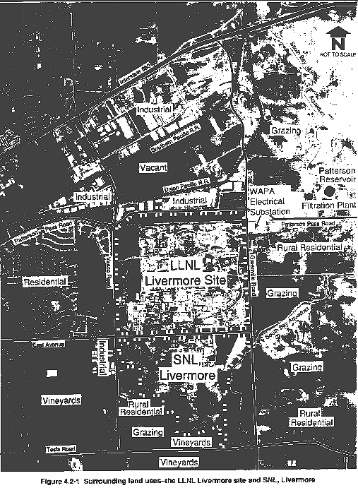
Figure 4.2-1 illustrates land uses near the LLNL Livermore site and SNL, Livermore. East Avenue divides the two Laboratory sites along the southern boundary of the LLNL Livermore site and the northern boundary of SNL, Livermore.
The LLNL Livermore site is bordered on the east by Greenville Road. The property east of Greenville Road, agricultural with a few scattered rural residences, is used primarily for grazing. A Western Area Power Administration electrical substation is on the southeast corner of Greenville Road and Patterson Pass Road. The South Bay Aqueduct, a branch of the California Aqueduct, traverses in a north-south direction the land east of the LLNL Livermore site and SNL, Livermore. The Patterson Reservoir and filtration plant for the South Bay Aqueduct are northeast of the LLNL Livermore site along Patterson Pass Road.
Patterson Pass Road runs along the northern boundary of the LLNL Livermore site. Across Patterson Pass Road to the north is a light-industrial park. A Union Pacific Railroad line runs in an east-west direction along the northern boundary of the industrial park. Land uses farther north include vacant land, industrial uses, a Southern Pacific Railroad line, and Interstate 580 (I-580). Land northeast of the site is agricultural and is used primarily for grazing. Wind turbines are installed on the hills of the Altamont Pass, northeast of the site.
On the west, the LLNL Livermore site is bordered by Vasco Road. A low-density, single-family residential subdivision begins at the southwest corner of Patterson Pass Road and Vasco Road and extends south and west. An area of vacant land lies directly west of the site (north of East Avenue), and low- to medium-density residential areas occur on the west side of this vacant land (approximately 2000 ft west of Vasco Road).
With the exception of the LLNL Livermore site to the north and a small light-industrial park on the southwest corner of East Avenue and Vasco Road, the primary land uses surrounding SNL, Livermore are rural residential and agricultural. Grazing is the primary agricultural activity to the west and east. Approximately 50 acres immediately to the south of SNL, Livermore are cultivated in vineyards. The agricultural lands south of Tesla Road and west of Greenville Road are also cultivated in vineyards.
Several easements for utilities cross the SNL, Livermore site. PG&E, for example, has easements for overhead high-voltage electric power transmission lines and an underground high-pressure gas line. Chevron U.S.A. has an easement for an underground oil line. In addition, the South Bay Aqueduct runs parallel to SNL, Livermore's eastern boundary.
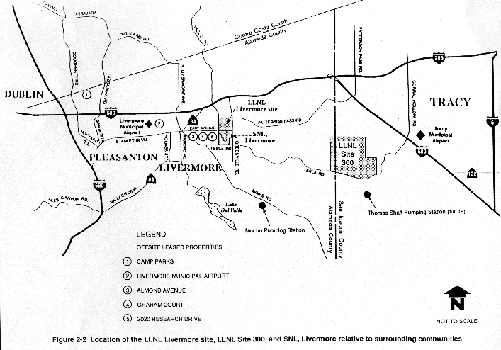
Additionally, LLNL conducts limited activities at various leased properties near the Livermore site. These include a storage area and office space at the Camp Parks facility in Dublin; a hangar at the Livermore Municipal Airport for an airplane that travels to and from DOE Nevada Test Site located north of Las Vegas, Nevada; a combination office, childcare, and classroom facility at Almond Avenue Site in Livermore; a storage warehouse with a service shop for the assembly of laser components at Graham Court in the City of Livermore; and a combination office and training center at 2020 Research Drive in Livermore. These nearby offsite leased properties are shown on Figure 2-2 in Section 2.
LLNL Site 300
Onsite Land Uses
LLNL Site 300 is on approximately 7000 acres of largely undeveloped land. The site has two remote high explosive firing areas supported by a chemistry processing area, a weapons test area, maintenance facilities, and a general services area at the site entrance.
Surrounding Land Uses
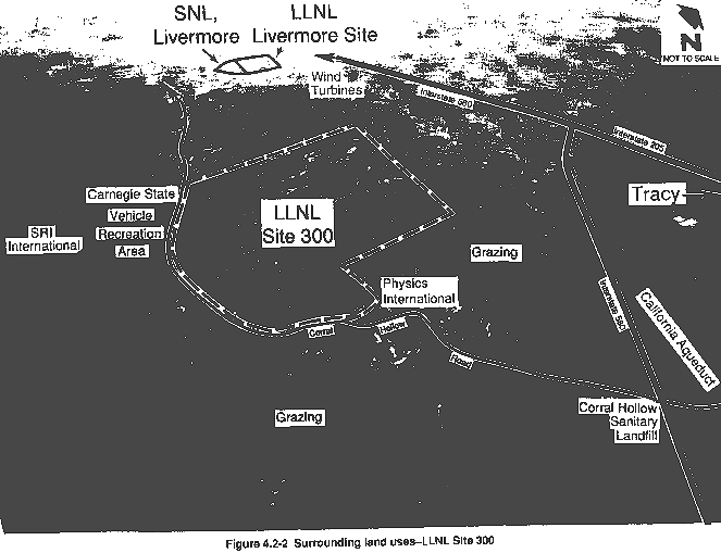
Figure 4.2-2 shows the existing land uses surrounding LLNL Site 300, the majority of which are agricultural, primarily for the grazing of cattle and sheep. Two other smaller, privately operated defense-related research and testing facilities are located near LLNL Site 300. East of and adjacent to LLNL Site 300 is the Physics International facility; a similar facility, operated by SRI International, is approximately 0.6 mile south of LLNL Site 300. Both of these facilities conduct high explosive tests.
Corral Hollow Road borders LLNL Site 300 on the south. South of the western portion of LLNL Site 300 across Corral Hollow Road is the Carnegie State Vehicular Recreation Area, covering approximately 16,020 acres and operated by the California Department of Parks and Recreation Off-Highway Motor Vehicle Recreation Division for the exclusive use of off-highway vehicles. The nearest urban area is the City of Tracy, approximately 8 miles northeast of LLNL Site 300. Several rural residences are located along Corral Hollow Road, west of LLNL Site 300 and the Carnegie State Vehicular Recreation Area. Power-generating wind turbines occupy the land northwest of the site.
4.2.2 Land Use Plans and Programs
For land use planning purposes, a city or a county general plan land use element generally contains a map showing land use designations. A land use designation is assigned to an area of land to indicate its planned and intended use to guide future development. While land use designations serve as a general guide for development, zoning designations are used as a tool for more specific land use regulation. A zoning designation is assigned to an area of land for the purpose of regulating its permitted use. Restrictions are placed upon use of the land according to its zoning designation as defined in the city or county zoning ordinance.
LLNL Livermore Site and SNL, Livermore
The City of Livermore and the County of Alameda do not have planning jurisdiction over the LLNL Livermore site and SNL, Livermore because they are federal facilities owned by DOE. However, for purposes of providing a complete description to the public and decision makers of the existing and potentially affected environment, local land use planning in the vicinity of the two sites is presented in this section.
The LLNL Livermore site and SNL, Livermore are in Alameda County. The western 1100 ft and the northern 500 ft of the LLNL Livermore site are within the City of Livermore. Although the remainder of the LLNL Livermore site and all of SNL, Livermore are outside the Livermore city limits, the sites remain within the City of Livermore's sphere of influence. The LLNL Livermore site, SNL, Livermore, and surrounding areas have land use designations under both the County of Alameda and City of Livermore general plans.
County of Alameda Planning Programs
County of Alameda General Plan: Livermore-Amador Valley Planning Unit. The Livermore-Amador Valley Planning Unit General Plan was adopted by the Alameda County Board of Supervisors on November 3, 1977. An update of the General Plan was adopted by the Board of Supervisors on December 12, 1989, but this update was challenged in a lawsuit and rendered invalid. The County of Alameda is presently preparing another update, which is scheduled for completion in April 1992 (Stein, 1992).
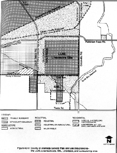
Figure 4.2-3 shows the Livermore-Amador Valley Planning Unit General Plan land use designations for the LLNL Livermore site, SNL, Livermore, and surrounding areas. The county describes its major land use designations as follows:
- Industrial Areas. This category provides for manufacturing and processing uses, as well as for administrative and laboratory uses.
- Industrial or Agricultural Areas. This category encourages the continuation of agricultural uses on large parcels that have been previously planned and/or zoned for industrial uses; however, it allows for industrial development when and if there is a need for land outside those areas specifically shown as industrial on the plan map. The plan encourages implementation measures, including rezoning to the "agricultural district" and use of the Agricultural Preserve program, to allow retention of agricultural uses on designated sites.
- Agricultural. This category allows for both intensive and extensive agricultural activities and for other open space uses, such as range and watershed management, consistent with site conditions and plan objectives and policies. The category includes privately held lands, as well as public ownerships not otherwise designated in the General Plan for "major park" or "major public" uses.
- Urban Residential Areas. Density and housing unit assumptions for the Livermore planning area are based on analysis of existing development, current zoning, and city and county plan development proposals. The General Plan indicates four urban residential density ranges: suburban, low, low medium, and high medium.
Most of the LLNL Livermore site is designated "industrial," and the perimeter areas on the western and northern portions of the site are designated "industrial or agricultural." Portions of SNL, Livermore are designated "industrial" and "industrial or agricultural."
Areas north and west of the LLNL Livermore site are designated for "industrial" and "low" to "low medium density" residential uses, respectively. Areas west of SNL, Livermore are designated "agricultural" and "industrial." Areas south and east of the LLNL Livermore site and SNL, Livermore are designated "agricultural."
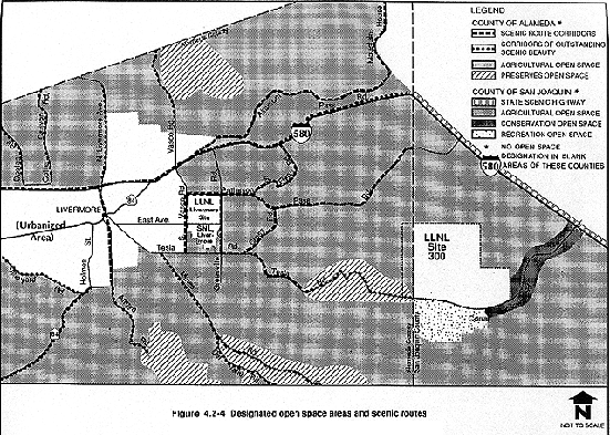
Open Space Element of the County of Alameda General Plan. The County of Alameda Board of Supervisors adopted the open space element of the County of Alameda General Plan on May 30, 1973. The open space element, consisting of a plan and a map, is designed to serve as a guide for the establishment of programs and legislation dealing with the preservation and enhancement of open space in the county. Four primary types of open space are defined in the element: agricultural open space, preserves, residential-canyon open space, and connecting open space corridors (County of Alameda, 1973). Figure 4.2-4 shows the open space element map designations for areas in the vicinity of the LLNL Livermore site and SNL, Livermore. Relevant principles from the open space element include:
- Locate Power, Research, or Defense Projects in Urban Areas Where Feasible. Installation of large-scale nuclear power plants, nuclear research projects, or defense installations requiring large shoreline or inland areas, should only be located in open-space areas when no alternative within an urban area is feasible; facilities should be located in such a manner to cause a minimum of interference with natural resources and wildlife.
- Convey Surplus or Excess Government Lands to Other Open-Space Uses. Large-scale government installations in planned open-space areas should be converted to other acceptable open-space uses when no longer required by the federal government. Such lands should be kept free of urban development whether acquired by public or private interests.
- Convert Excess Federal, State, and Local Parcels in Urban Areas to Open-Space Uses. Whenever feasible, local agencies should acquire excess federal, state, and local parcels in open areas for open-space uses, where they would enhance the county or local open-space plan.
- Limit Development in Agricultural Areas. Agricultural areas should be free of urban development, with dwellings permitted only for those persons involved in agricultural production.
Livermore-Amador Valley Planning Unit General Plan. Portions of the open space element of the County of Alameda General Plan have been superseded by the Livermore-Amador Valley Planning Unit General Plan, which was adopted by the Alameda County Board of Supervisors on November 3, 1977. The Livermore-Amador Valley Planning Unit General Plan includes an open space map, policies, and proposals (County of Alameda, 1977). Open space areas designated by the Livermore-Amador Valley Planning Unit General Plan are illustrated on Figure 4.2-4. As the figure indicates, two major categories of open space are specified:
- Agricultural Open Space. This category includes cultivated and uncultivated agricultural areas.
- Preserve Open Space. This category includes existing and proposed major parks, as well as major publicly owned open space areas, such as the watershed lands of the San Francisco Water Department.
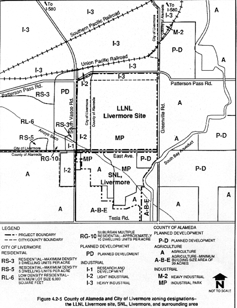
County of Alameda Zoning. County of Alameda Zoning Code designations for the LLNL Livermore site, SNL, Livermore, and surrounding areas are shown in Figure 4.2-5 (County of Alameda, 1988). The LLNL Livermore site lies within the County of Alameda and most of it is zoned "M-P" for industrial park use. The Alameda County Ordinance Code specifies "laboratory, including research, commercial, testing, developmental, experimental or other types" as a permitted use within the M-P zone. The remaining portions of the LLNL Livermore site lie within the City of Livermore and are not subject to county zoning. The developed portion of SNL, Livermore is zoned "M-P" for industrial use; the western and southern perimeter areas are designated "A" for agricultural; and the undeveloped northeast corner of the site is designated "P-D" for planned development.
Areas east of the LLNL Livermore site are designated "A" for agricultural uses and "P-D" for planned development. Areas surrounding SNL, Livermore to the west, south, and east are designated "A" for agricultural use, "A-B-E" for agricultural use with a minimum building lot size of 20 acres, and "P-D" for planned development.
South Livermore Valley General Plan Amendment. The South Livermore Valley Plan Area encompasses approximately 15,585 acres in the southeastern portion of Alameda County. An amendment to the Alameda County General Plan for the Livermore-Amador Valley Planning Unit is being proposed to revise the land classifications for the area and to establish boundary areas, densities, and development conditions to protect viticultural uses (cultivation of grapes) and to promote the area as a wine region (County of Alameda, 1991). On August 6, 1991, the Alameda County Planning Department released a Notice of Preparation of an Environmental Impact Report for the South Livermore Valley General Plan Amendment. The environmental documentation is expected to be completed by March 1992 (Madigan, 1991).
City of Livermore Planning Programs
Livermore Community General Plan 1976–2000. The Livermore Community General Plan 1976–2000 was adopted by the Livermore City Council on March 8, 1976. The planning area for the City of Livermore encompasses approximately 139 square miles and is bounded on the north generally by the Alameda County line, on the east by the ridgeline of the Altamont Hills, on the south by a line 8 miles south of the Livermore City Hall, and on the west by the Murray-Pleasanton Township (City of Livermore, 1976a). Among the relevant land use policies in the General Plan are the following:
- The City shall encourage the retention in open space of as much land as possible for agriculture, viticulture, rangeland, and grassland (Resolution No. 167-83).
- Open space shall be used to protect and enhance local community character and identity, and to guide the physical shape and direction of urban growth to preserve the rural characteristics of the area.
- Open space shall be used as a buffer between incompatible land uses within urban or essentially undeveloped areas.
- The City shall apply regulations that reserve large tracts for exclusive industrial use to encourage development of an industrial "community" and prevent encroachment by incompatible uses.
- The City shall make industrial development subject to design principles and performance standards that support environmental resources management policies.
Figure 4.2-6 illustrates the land use designations for the LLNL Livermore site, SNL, Livermore, and surrounding areas as determined by the Livermore Community General Plan land use map (City of Livermore, 1988a). Most of the LLNL Livermore site is designated "low intensity industrial," with the northern 500-ft perimeter area designated "high intensity industrial." A portion of SNL, Livermore is designated "low intensity industrial," and the remainder is designated "limited agricultural" with a 20-acre minimum lot requirement (i.e., a maximum of one housing unit per 20 acres).
Areas north of the LLNL Livermore site are designated "high intensity industrial." Areas west of the LLNL Livermore site are designated for "low medium density" to "high density" residential uses. Areas west of SNL, Livermore are designated "limited agricultural" with a 20-acre minimum lot requirement, "low intensity industrial," and "viticulture" with a 100-acre minimum lot requirement. Areas south and east of the LLNL Livermore site and SNL, Livermore are designated "limited agricultural" with a 20-acre minimum lot requirement, and "range and grassland" with a 100-acre minimum lot requirement.
North Livermore Area "A" General Plan Amendment. The Livermore City Council adopted the North Livermore Area "A" General Plan Amendment in March 1988 (City of Livermore, 1988b). North Livermore Area "A" comprises the portion of North Livermore bordered on the west by the western city limits of the Springtown community, on the north and east by the base of the Livermore foothills, and on the south by I-580. The North Livermore Area "A" General Plan Amendment revised the pattern of residential land uses and densities, and provided for supporting neighborhood commercial facilities, community facilities, and open space uses. The amendment provides for a 35 percent increase in residential land use, a 54 percent increase in commercial use, a 32 percent reduction in public facility use, and a 51 percent reduction in open space and agriculture use over a 20–25 year planning horizon. In 1988, it allowed for approximately 3000 more dwelling units and approximately 170 more commercial acres to be built in the Springtown Community.
City of Livermore Zoning. City of Livermore zoning designations for the LLNL Livermore site and surrounding areas within the City of Livermore are shown in Figure 4.2-5 (City of Livermore, 1990). The northern perimeter area is zoned "I-3" for heavy industrial use, and the western perimeter area is zoned "I-2" for light industrial use. The City of Livermore Zoning Ordinance specifies "research and development facilities; professional and administrative offices; and off-street parking" as principal permitted uses within the I-2 and I-3 zones (City of Livermore, 1991b).
Surrounding areas north of the LLNL Livermore site are designated "I-3" for heavy industrial use. Areas west of the LLNL Livermore site are designated "PD" for planned development, "RS-3" for residential use with a maximum density of 3 dwelling units per acre, "I-1" for research and development use, "I-2" for light industrial use, "RG-10" for suburban multiple-residential use (approximately 10 dwelling units per acre), "RS-5" for residential use with a maximum density of 5 dwelling units per acre, and "RL-6" for low-density residential with a minimum lot size of 6000 sq ft.
LLNL Site 300
Most of LLNL Site 300 is in San Joaquin County, with a small portion in Alameda County. The City of Tracy is located approximately 8 miles east of the site. Planning programs of these three agencies are addressed below to provide a basis for evaluating LLNL Site 300's compatibility with future surrounding land uses. The counties of San Joaquin and Alameda and the City of Tracy do not have planning jurisdiction over LLNL Site 300 because it is a federal facility owned by DOE.
County of San Joaquin Planning Programs
San Joaquin County General Plan. The San Joaquin County General Plan was adopted by the San Joaquin County Board of Supervisors on April 13, 1976 (County of San Joaquin, 1976). The land use/circulation element of the General Plan contains goals, objectives, and principles for land use development and circulation and transportation within the County of San Joaquin. An update to the General Plan is being prepared by the County of San Joaquin and is scheduled to be complete by April 1992 (Islas, 1992). The update will consider several new proposed communities within the county.
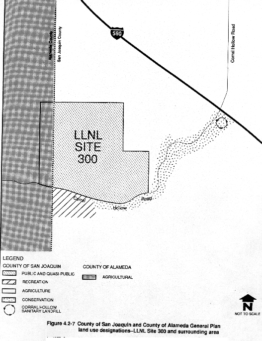
Figure 4.2-7 shows the land use designations for LLNL Site 300 and the surrounding areas. San Joaquin County General Plan land use designations can be summarized as follows:
- Public and Quasi-Public—Other Governmental and Institutional. This category indicates the locations of a variety of activities including military installations, correctional institutions, fire stations, hospitals, civic centers, fairgrounds, and major government buildings, as well as public transportation facilities.
- Recreation. These areas encompass lands with important recreational potential. It is intended that these areas be utilized through either public or private development. Within the Commercial Recreation areas, the building density shall not exceed one dwelling unit per 2 gross acres. The population density in Commercial Recreation areas is three persons per 2 gross acres.
- Agriculture. This category includes areas where there are high-quality soils and where water is, or is expected to be, available for irrigation. It also includes foothill pasture areas that support livestock production and are intended to remain in agricultural use. This designation allows 1 to 16 primary dwelling units per 160 gross acres.
- Conservation. This category identifies areas that are intended to remain in open space to conserve natural resources or to protect development from probable hazards. Included are floodplains, areas of substantial aquifer recharge, sand and gravel deposits, and wildlife habitats. This designation allows 1 to 16 primary dwelling units per 160 gross acres.
The portion of LLNL Site 300 in the County of San Joaquin is designated "public and quasi-public." Areas north and east of LLNL Site 300 are designated "agricultural." Areas south of LLNL Site 300, along Corral Hollow Road, are designated "recreation" and "conservation."
Open Space/Conservation Element of the San Joaquin County General Plan. The open space/conservation element of the San Joaquin County General Plan was adopted by the San Joaquin County Board of Supervisors on June 19, 1973. The plan map and text description were amended by the Board of Supervisors on May 9, 1974. The goal of the element is "to stimulate the creation and maintenance of an open space system, balanced with other land uses to enhance the present and future environments in San Joaquin County" (County of San Joaquin, 1973).
The open space/conservation element refers to the General Plan land use map to show the locations of open space and conservation areas. As illustrated in Figure 4.2-4, a corridor along Corral Hollow Road is designated as a "conservation area," and the areas surrounding LLNL Site 300 to the north, south, and east are designated as "extensive agricultural areas." The following is a brief description of these designations as provided in the open space/conservation element:
- Extensive Agricultural Areas. These areas contain poorer quality soils and cannot generally be considered prime agricultural land.
- Conservation Areas. These are areas of substantial aquifer recharge, floodplains, excellent wildlife habitat, sand and gravel deposits, and regional parks. Designated conservation areas are intended to remain in open space to protect natural resources.
County of San Joaquin Zoning. The portion of LLNL Site 300 in San Joaquin County is zoned "AG-160" for general agriculture with a 160-acre minimum parcel size. The AG zone was established to preserve agricultural lands for the continuation of commercial agricultural enterprises. In addition, hazardous industrial operations using explosives are permitted within the AG zone, subject to use permits (County of San Joaquin, 1988).
County of Alameda Planning Programs
County of Alameda General Plan: Livermore-Amador Valley Planning Unit. As illustrated in Figure 4.2-7, the County of Alameda General Plan for the Livermore-Amador Valley Planning Unit designates this portion of LLNL Site 300 as "agricultural." The above discussion under "LLNL Livermore Site and SNL, Livermore" provides a definition of the "agricultural" land use designation of the County of Alameda General Plan.
County of Alameda Zoning. The portion of LLNL Site 300 in the County of Alameda is zoned "A" for agricultural use. The Alameda County Ordinance Code specifies "remote testing facilities" as a conditional use within the A district, subject to approval by the zoning administrator for Alameda County (Sections 8-94.0 and 8-25.0).
City of Tracy Planning Programs
City of Tracy General Plan. LLNL Site 300 is approximately 8 miles southwest of the City of Tracy. According to the City of Tracy General Plan land use map, LLNL Site 300 is outside the city's sphere of influence, which extends as far south as the Tracy Municipal Airport (City of Tracy, 1990). Therefore, the City of Tracy General Plan is not applicable to LLNL Site 300, but its provisions have been studied for implications relevant to LLNL Site 300. The City of Tracy General Plan is being updated and is scheduled for completion in June 1992 (Bell, 1991).
Other Relevant Planning Programs
Livermore Municipal Airport Master Plan
LLNL leases a hangar at the Livermore Municipal Airport for the storage of a Fairchild F-27F aircraft operated by Aviation Methods Incorporated under contract to LLNL. (Section 4.13 and Appendix K provide information on current airport operations.)
The Master Plan for the Livermore Municipal Airport, prepared for the City of Livermore in 1975, provides guidelines for the future development of airport facilities (City of Livermore, 1975). The master plan includes a land use map for the airport vicinity, illustrating projected land uses for the year 1995. Land uses shown on this map are consistent with existing land uses surrounding the airport, with the exception that the area adjacent to the southern boundary of the airport is designated for future "general or light industry."
On March 25, 1991, the City Council of the City of Livermore established an airport protection area (Resolution No. 90-91) (City of Livermore, 1991a). The amendment prohibits new residential land use designations or the intensification of existing land use designations within the airport protection area, which covers an area 5000 ft north, east, and south and 7100 ft west of the airport runways. The protection area was established to ensure continued safety in the airport region and to avoid potential noise incompatibilities between the airport and encroaching residential uses.
Tracy Municipal Airport Master Plan
The Tracy Municipal Airport is located within the southwestern portion of the City of Tracy. The airport is surrounded by aggregate mineral extraction operations to the north, south, and east. The Delta-Mendota Canal borders the airport on the west and southwest. LLNL utilizes the airport for the transport of high explosive shipments according to a verbal agreement with airport authorities. Section 4.13 provides information on current airport and LLNL-related operations.
The Tracy Municipal Airport Master Plan was prepared in 1975 for the City of Tracy (City of Tracy, 1975). The master plan provides data from 1975 on airport facilities and operations, airport capacity, and a forecast of future airport demands. An updated 20-year master plan for the Tracy Municipal Airport is expected to be released in June 1992 (Pellegrino, 1992).
|
NEWSLETTER
|
| Join the GlobalSecurity.org mailing list |
|
|
|