


4.17 SITE CONTAMINATION AND REMEDIATION
This section presents a general overview of historic operations that contributed to contamination (4.17.2.1, 4.17.3.1, 4.17.4.1), describes and summarizes soil contaminant areas (4.17.2.2, 4.17.3.2, 4.17.4.2) for the LLNL Livermore site, LLNL Site 300, and SNL, Livermore, respectively, and describes ground water contamination at the LLNL Livermore site (4.17.2.3) and LLNL Site 300 (4.17.3.2). The LLNL Livermore site and LLNL Site 300 have been identified as Superfund sites under CERCLA/SARA and were placed on the National Priorities List (NPL) in 1987 and 1990, respectively. This section is complemented by section 4.13, which provides detailed information about hazardous and radioactive materials used onsite, and section 4.14 and Appendix C, which present detailed information regarding health risks associated with materials present at the Laboratories. Section 4.19 presents a discussion of the environmental effects on the existing environment assuming no remediation of areas contaminated by past activities.
4.17.1 Regulatory Oversight
Regulatory oversight of environmental restoration activities is provided by numerous entities including federal, state, and county agencies. A listing of applicable laws and regulations and the implementing agencies is included in Table 4.17-1.
LLNL Livermore Site
Pursuant to CERCLA Section 120, a Federal Facility Agreement (FFA) was signed by DOE, the EPA, the Regional Water Quality Control Board, and the Department of Health Services (now part of the California Environmental Protection Agency, Department of Toxic Substances Control [DTSC]), covering cleanup activities at the LLNL Livermore site. The Federal Facility Agreement coordinated efforts among these agencies to standardize requirements and to ensure compliance with applicable or relevant and appropriate requirements, orders, and permits (DOE, 1989a). The Federal Facility Agreement also specifies a schedule and details of project operation and management. An Environmental Assessment (EA) on the remediation activities subject to the Federal Facility Agreement was written as a chapter within the Feasibility Study documents prepared pursuant to NEPA and CERCLA (LLNL, 1991f).
The LLNL Ground Water Project of the Environmental Restoration Division has primary responsibility for investigation and remediation efforts under the Federal Facility Agreement. The project's name reflects the emphasis of the investigation at the LLNL Livermore site. As closely related media for contamination, ground water and soil receive primary emphasis from investigation and remediation efforts. The Ground Water Project holds public meetings, publishes a newsletter, and has formed a Community Work Group to keep the public informed and to provide a pathway for public input to the remedial action process (LLNL, 1991f).
Before the LLNL Livermore site Federal Facility Agreement was executed in 1989, the Ground Water Project activities were conducted under regulatory orders and permits and the primary oversight by the San Francisco Bay Regional Water Quality Control Board. Beginning in 1984, LLNL discharges to land and water were regulated by a series of orders issued by the Regional Water Quality Control Board or by the Department of Health Services (now the Department of Toxic Substances Control) (Table 4.17-2). Two orders specifying waste discharge requirements are currently in effect (Table 4.17-2). The remaining orders have been rescinded, or their provisions have been incorporated into the Federal Facility Agreement. Air emissions from treatment of ground water associated with the Ground Water Project are regulated by the Bay Area Air Quality Management District.
LLNL Site 300
LLNL Site 300 was placed on the National Priorities List in 1990 because volatile organic compounds were discovered in the regional aquifer underlying the site and because of the proximity of the contamination to private drinking water supplies. A Federal Facility Agreement covering cleanup activities at LLNL Site 300 was executed on June 29, 1992.
SNL, Livermore
The Regional Water Quality Control Board, San Francisco Bay Region, has identified Environmental Restoration Program activities at SNL, Livermore to be performed under a Revised Site Cleanup Order (No. 89-184), which modified Order No. 88-142, and the rescission of Order No. 85-106, dated September 21, 1988. Order No. 88-142 was issued to "consolidate all site work accomplished by Sandia Corporation and within DOE Environmental Restoration Program, and to set forth provisions and specifications for development and implementation of site cleanup alternatives for identified areas of soil and ground water pollution."
Table 4.17-1 Representative Listing of Federal, State, and Local Regulatory Requirements Affecting Environmental Restoration
| Laws, Regulations and Requirements | Responsible Agencies |
| Air Toxics "Hot Spots" Information and
Assessments Act (Health and Safety Code sections 44300 et seq.) |
California Air Resources Board |
| California Clean Air Act (Health and Safety Code sections 39000 et seq.) |
California Air Resources Board |
| California Safe Drinking Water and Toxic
Enforcement Act (Health and Safety Code sections 25249.5 et seq.)* |
California Environmental Protection Agency |
| California Porter-Cologne Water Quality Act (Water Code sections 13000 – 13999.16) |
California Water Resources Control Board and Regional Water Quality Control Board |
| California Hazardous Waste Control Act (Health and Safety Code sections 25100 et seq.) |
California Environmental Protection Agency |
| City of Livermore Sewage Discharge Regulations | City of Livermore, CA |
| Clean Air Act
(42 U.S.C. sections 7401 et seq.) |
U.S. Environmental Protection Agency |
| Clean Water Act (33 U.S.C. sections 1251 et seq.) |
U.S. Environmental Protection Agency |
| Comprehensive Environmental Response Compensation
and Liability Act/Superfund Amendments and Reauthorization
(42 U.S.C. sections 9601 et seq.) |
U.S. Environmental Protection Agency |
| National Environmental Policy Act of 1969 (42 U.S.C. sections 4321 et seq.) |
Council on Environmental Quality |
| Noise Control Act of 1972
(42 U.S.C. sections 4901 et sq.) |
U.S. Environmental Protection Agency |
| Occupational Safety and Health Act of 1970 (29 U.S.C. sections 651 et seq.) |
U.S. Department of Labor |
| Resource Conservation and Recovery Act (42 U.S.C. sections 6901 et seq.) |
U.S. Environmental Protection Agency |
| Safe Drinking Water Act (42 U.S.C. sections 300 et seq.) |
U.S. Environmental Protection Agency |
| Toxic Substance Control Act
(15 U.S.C. sections 2601 et seq.) |
U.S. Environmental Protection Agency |
| DOE Order 5000.3A
"Occurrence Reporting and Processing Operating Information" |
U.S. Department of Energy |
| DOE Order 5400.1
"General Environmental Protection Program" |
U.S. Department of Energy |
| DOE Order 5400.2A
"Environmental Compliance Issue Coordination" |
U.S. Department of Energy |
| DOE Order 5400.5
"Radiation Protection of the Public and the Environment" |
U.S. Department of Energy |
| DOE Order 5400.6C
"Quality Assurance" (draft) |
U.S. Department of Energy |
| DOE Order 5480.1B
"Environment, Safety, and Health Program for Department of Energy Operations" |
U.S. Department of Energy |
| DOE Order 5480.4
"Environmental Protection, Safety, and Health Protection Standards" |
U.S. Department of Energy |
| DOE Order 5480.8
"Contractor Occupational Medicine Program" |
U.S. Department of Energy |
| DOE Order 5480.10 "Contractor Industrial Hygiene Program" |
U.S. Department of Energy |
| DOE Order 5480.11 "Radiation Protection for Occupational Workers" |
U.S. Department of Energy |
| DOE Order 5480.19
"Conduct of Operations Requirements for DOE Facilities" |
U.S. Department of Energy |
| DOE Order 5482.1B
"Environment, Safety, and Health Appraisal Program" |
U.S. Department of Energy |
| DOE Order 5484.1
"Environment, Safety, and Health Protection Information Reporting Requirements" |
U.S. Department of Energy |
| DOE Order 5484.1A
"Occupational Safety and Health Program for Government-Owned, Contractor-Operated Facilities" |
U.S. Department of Energy |
* Applies to SNL, Livermore, but not to LLNL.
4.17.2 Site Contamination-LLNL Livermore Site
4.17.2.1 Contamination History
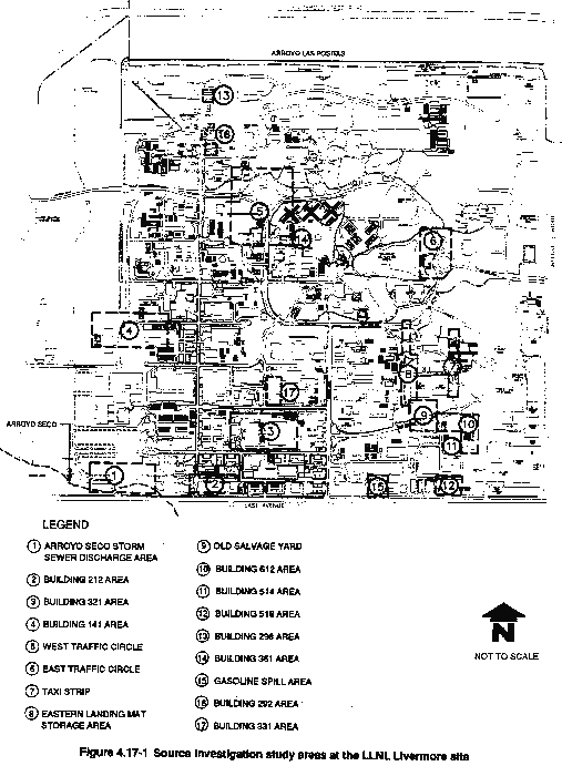
To simplify compliance with CERCLA/SARA, LLNL combined the entire LLNL Livermore site and offsite leased properties into one remedial investigation/feasibility study unit (Thorpe et al., 1990). The following section describes the historic use of hazardous and radioactive material within this unit. Sections 4.17.2.2 and 4.17.2.3 describe each of 17 potential contaminant release areas investigated by March 1991 at the LLNL Livermore site. The locations of the 17 areas are shown in Figure 4.17-1. The results from sitewide ground water investigations are summarized in section 4.17.2.3. Table 4.17-3 lists activities at each area that may have contributed to contamination.
The earliest use of the LLNL Livermore site by the federal government began in 1942 with the Livermore Naval Air Station. Subsequently, other federal entities assumed ownership or occupation. In 1952, the University of California Radiation Laboratory assumed care, custody, and control of the government-owned land to conduct research on nuclear weapons and magnetically confined nuclear fusion (LLNL, 1989a).
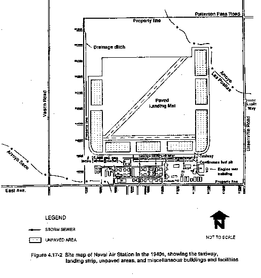
The earliest use of hazardous materials at the LLNL Livermore site was by the U.S. Navy. A site map of the Naval Air Station is shown in Figure 4.17-2. Based on information obtained from records at the Navy Historical Center at the Washington Navy Yard and the Military Records Branch of the National Archives in Washington, D.C., it was determined that trichloroethylene (TCE), perchloroethylene (PCE), 1,1-dichloroethylene (1,1-DCE), 1,2-dichloroethylene (1,2-DCE), and carbon tetrachloride (CCl4) were used routinely by the U.S. Navy at the Livermore Naval Air Station during World War II (LLNL, 1989a).
During the Navy's occupation of the area, much of the engine assembly, repair, and overhaul operations involving these compounds was performed in Building 511 and Building 514, located in the southeastern part of the site. Additionally, aircraft were reassembled and wiped down on parking aprons adjacent to the main runways. Paint stripping compounds included dichloroethylene, ethyl acetate, ethylene dichloride, carbon tetrachloride, methanol, and acetone (Graham, 1987). Organic solvents were also used in the unpaved and undeveloped areas flanking the paved runway and aprons (Webster-Scholten et al., 1987). These unpaved zones overlap areas where concentrations of volatile organic compounds (VOCs) are currently above action levels (Webster-Scholten et al., 1987; Graham, 1987). There is evidence that residues from "empty" barrels and drums were drained in the unpaved area above the northwest corner of the old salvage yard and along the east side of the Taxi Strip (Dreicer, 1985). An aerial photograph taken some time between 1942 and 1944 shows a disposal and burn pit located between the middle and southern blocks of the eastern unpaved areas. This pit was graded and covered when the U.S. Navy left the site (Graham, 1987).
From 1950 to 1952, in the area currently occupied by Building 431, the California Research and Development Corporation constructed the Materials Test Accelerator to demonstrate the feasibility of using high-energy neutrons to produce nuclear materials, such as tritium and plutonium, although these materials were never processed there. Cells were built just south of Building 412 to house large hardware for chemical engineering work. It is likely that oils, grease, and solvents were used in this building. Radioactive and hazardous materials were used in the California Research and Development Corporation facilities at Building 514, and the building housed a decontamination laundry. In 1953 and 1954, Pratt and Whitney leased Building 412 and converted the previously established cells into hot cells for metallurgical research using uranium (Dreicer, 1985).
During the 1950s and 1960s, new plastics, composite materials, and coatings required the use of small quantities of diverse types of hazardous and radioactive materials. Operation and maintenance of buildings, utilities, and specialized equipment generated the same types of hazardous wastes as those produced by any large vehicle and facility maintenance operation, including waste fuels, oils, hydraulic fluids, coolants, pesticides, biocides, acids, bases, paints, and varnishes.
Table 4.17-2 California Regulatory Orders for the LLNL Ground Water Investigation Governing the Discharge of Treated Ground Water to Land or Waterways
| Order Number | Date | Purpose | Issuing Agency | Currently in Effect |
| 91-106 | 6/18/91 | Waste Discharge Requirements (NPDES No. CA 0029289) Allows discharge of treated ground water. This NPDES permit rescinds order No. 90-106. | RWQCBa | Yes |
| 90-106 88-103 |
6/15/88 | Site Cleanup Order. Allows discharge of ground water (with specified quality limits), and specifies time frame for investigation and cleanup activities. This order rescinds 87-108. | RWQCB | Nob |
| 88-075 | 5/18/88 | Waste Discharge Requirements and Self Monitoring Program. Allows discharge of treated water associated with pilot treatment facility A (with specified quality limits) to the ground. | RWQCB | Yes |
| 88-065 | 4/20/88 | Waste Discharge Requirements (NPDES No. CA 0029289). Allows discharge of ground water (with specified quality limits) to the ground, to storm sewers, or to existing arroyos. | RWQCB | No |
| 87-108 | 8/19/87 | Site Cleanup Order. Allows discharge of ground water (with specified quality limits) and specified time frame for investigation and cleanup activities. This order rescinds 86-95 and 85-134. | RWQCB | No |
| 86-95 | 12/17/86 | Waste Discharge Requirements for Short-Term Well Tests. Allows discharge of ground water (with specified quality limits) to land during short-term hydraulic tests. | RWQCB | No |
| 85-134 | 11/20/85 | Waste Discharge Requirements. Allows discharge of ground water (with specified quality limits) to land during early investigations to determine (1) the extent that the ground water has been affected by hazardous constituents, and (2) the hydrogeologic conditions. | RWQCB | No |
| --- | 9/11/84 | Order for Compliance. Requires investigation of ground water quality at LLNL and orders bottled water to be provided to area residents whose domestic wells have been affected by hazardous constituents. | DHSc | Nob |
a Regional Water Quality Control
Board.
b Provisions of this order were
incorporated into the Federal Facility Agreement.
c Department of Health Services.
Table 4.17-3 Activities at LLNL That May Have Contributed to Environmental Contamination
| Areas Investigated | Period of Operation | Comments |
| Arroyo Seco Storm Sewer Discharge Area (1) | 1940s to present | Storm drain discharge to natural surface water drainage for LLNL and SNL during Navy Operations. |
| Building 212 Area (2) | 1940s to present | Built in 1940s; accelerator research 1950s to present. |
| Building 321 Area (3) | 1954 to present | Machine, plating, and small shops. |
| Building 141 Area (4) | 1953 to present | Built over and added to since 1953; old taxiway and unpaved areas, materials staging area and circuit board shop. |
| West Traffic Circle (5) | 1940s to 1975 | Former landing mat; traffic circle built in 1975. |
| East Traffic Circle (6) | 1942 to 1946 | Former unpaved parking apron for planes 1942–1946; used for paint stripping, degreasing and cleaning. Landfill established in late 1940s; excavated 1984. |
| Taxi Strip (7) | 1942 to 1983 | Constructed circa 1942; planes were cleaned; glass carboy storage 1953–1959; radioactive evaporation tray 1963–1976 known to have leaked; area excavated 1982–1983. |
| Eastern Landing Mat Storage Area (8) | 1942 to 1970s | Constructed circa 1942; used for salvage and storage. |
| Old Salvage Yard (9) | 1958 to 1979 | Salvage and scrap operations. |
| Building 612 Area (10) | 1966 to present | Constructed in 1966; solid waste holding and shipment facility for radioactive and hazardous materials. |
| Building 514 Area (11) | 1942 to present | Engine cleaning area. Radionuclide and mixed waste storage and treatment, 1960s to present; possible plutonium release 1967. |
| Building 518 Area (12) | 1959 to present | Gas cylinder, solvent, and oil storage. |
| Building 298 Area (13) | 1970s | Circa 1970s; used kerosene, gasoline, and jet fuel. |
| Building 361 Area (14) | 1950s to 1960s | Used kerosene, gasoline, and jet fuel at Fire Training Area. |
| Gasoline Spill Area (15) | 1952 to 1979 | Between 1952 and 1979, about 17,500 gal of leaded gasoline may have been lost. |
| Building 292 Area (16) | 1977 to 1987 | A rotating target neutron source (RTNS) was used for research between 1977 and 1987. In 1989 a leak test identified leaks in a 1000-gal underground tank that had contained tritiated rinsewater. On December 23, 1990, a cold water pipe froze and broke in Building 292 releasing 4000 gal of tritiated water to floor drains connected to the tank. A portion of the water was recovered; an unknown quantity of tritiated water leaked into soils near the tank. |
| Building 331 Area (17) | 1956 to present | Hydrogen Research Facility. Tritium contaminated solvents and water. Tritium contaminated solid handling materials, oils, solvents, and chlorinated solvents. Tritium gas. |
4.17.2.2 Soil Contamination Areas
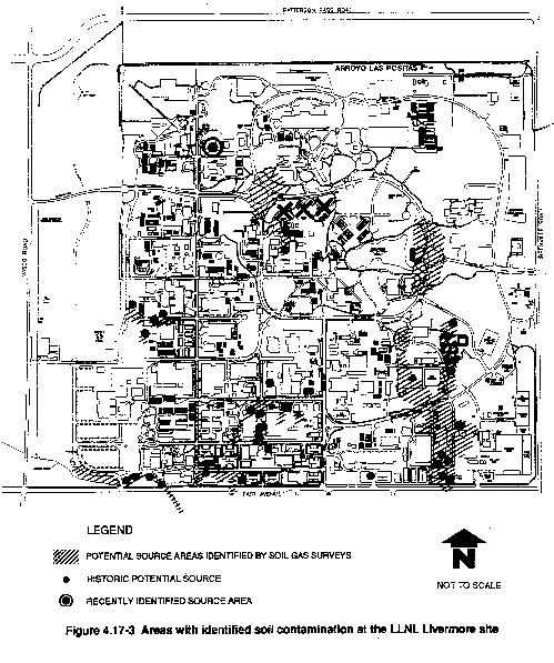
Unsaturated or vadose zone soil and sediment contaminants and their distribution were identified during investigations of potential source areas (Figure 4.17-3) through surface sediment sampling, unsaturated zone soil vapor surveys, and boring programs. Potential contaminants identified include volatile organic compounds, fuel hydrocarbons, pesticides, polychlorinated biphenyls, metals, and tritium. Many potential source areas have been investigated at the LLNL Livermore site (Thorpe et al., 1990), and other source investigations are ongoing (Devany et al., 1990).
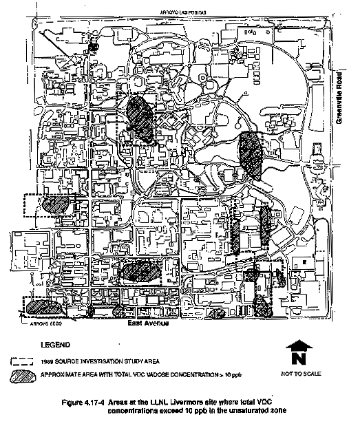
Tables 4.17-4 and 4.17-5 summarize contaminants detected in potential source areas investigated at the LLNL Livermore site. The areas investigated are shown in Figure 4.17-1. This document uses the common nomenclature of parts per million (ppm) and parts per billion (ppb) to identify concentrations of contaminants in soils and ground water. For reference, mg/kg (or mg/L) is equivalent to ppm and mg/kg (or mg/L) is equivalent to ppb. Sediment samples from potential source areas generally contained total concentrations of volatile organic compounds ranging from less than 5 ppb to 500 ppb, with most containing less than 100 ppb. The estimated volume of volatile organic compounds in unsaturated sediments beneath the LLNL Livermore site is about 54 gals (see Table 4.17-6). Figure 4.17-4 shows the approximate areas where total concentrations exceed 10 ppb in the unsaturated zone at the LLNL Livermore site.
Only one surficial sediment sample contained detectable levels of pesticides (88 ppb Lindane). Polychlorinated biphenyls (Aroclor-1254) were found at nine storm drain and surficial sediment sample locations at concentrations up to 1300 ppb (Thorpe et al., 1990). No metals have been detected in soils or in the vadose zone in concentrations exceeding Soluble Threshold Limit Concentrations except for lead which was detected at one location at 18 mg/kg (Soluble Threshold Limit Concentration=5 mg/kg).
Tritium activities from unsaturated sediments are reported in picocuries per liter of soil moisture (pCi/Lsm). Areas with soil tritium activities significantly above the LLNL Livermore site background level (500 pCi/Lsm) include Building 514, Building 292, Eastern Landing Mat, Building 331, and Taxi Strip areas (Isherwood et al., 1990; Dresen et al., 1991; Stone et al., 1982). Maximum concentrations reported for these areas range from 9.4×10⁴ pCi/Lsm (Eastern Landing Mat) to 2.2×10⁸ pCi/Lsm (Building 292).
Continuing investigation of sites to determine the existence and extent of contamination is a key element in the Environmental Program at LLNL (LLNL, 1991i). Currently, over 17 additional sites are being investigated.
The following sections describe individual areas, including for each the site history, nature and extent of soil contamination, existing situation, and any planned remediation activities for sites that have been identified and fully characterized. Table 4.17-7 presents the key references to additional technical information for each area. Table 4.17-5 presents an overview of the potential soil contamination from identified industrial activity or the discharge of hazardous materials, and the contaminants identified by laboratory analyses of the soil samples.
Arroyo Seco Storm Sewer Discharge Area
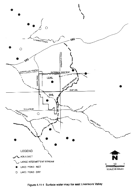
The Arroyo Seco channel historically has been the natural drainage for surface waters in the southern portion of LLNL and SNL, Livermore. The Arroyo Seco originates in the hills southeast of LLNL and flows northwest across SNL, Livermore before entering the southwest corner of LLNL as shown in Figure 4.11-1. A 300-ft section of the channel was diverted in 1966 so that Building 113 could be constructed. Beyond this diversion, the channel returns to its original course.
Release of hazardous materials such as solvents, fuels, and oils to the subsurface is thought to be principally from storm drain discharge during the U.S. Navy's use of the site (Dresen and Hoffman, 1986). Solvent spills, potassium dichromate from Building 113, fuel and oil from an auto repair shop, and polychlorinated biphenyls from a ruptured transformer are other potential sources of contamination.
Contaminants identified in the soil and vadose zone are presented in Table 4.17-5. Perchloroethylene was the most widespread volatile organic compound, although minor quantities of fuels and aromatic hydrocarbons were also found. There was no evidence of any release of metals or radioactive material in this area.
Building 212 Complex
Building 212, in the southwest area of the LLNL Livermore site (see Figures 4.17-1 and 4.17-2), was constructed by the U.S. Navy in the early 1940s and used as a drill hall and gymnasium. From the early 1950s to the present, LLNL has used the building for accelerator research. The building also housed machining, plating, electronic fabrication shops, and a mercury reclaimer, which generated small amounts of nonradioactive hazardous waste. Although possible releases of hazardous materials by the mercury reclaimer have not been evaluated, mercury has not been detected above the maximum contaminant level in LLNL ground water (Thorpe et al., 1990).
Volatile organic compounds listed in Table 4.17-5 have been found in trace to low concentrations in sediments. Although there is no surficial or other recorded evidence of previous release of aromatic hydrocarbons in this area, saturated and unsaturated sediments from one borehole showed from trace to very low concentrations of benzene, toluene, ethylbenzene, and xylene. There is no evidence of any release of metals or polychlorinated biphenyls in this area.
Building 321 Complex
Construction of the Building 321 complex began in 1954, with additions made in 1959, 1962, 1967, and 1985. The complex (shown in Figure 4.17-1) overlies portions of the "warm-up" concrete apron used by naval aircraft when the site was the Livermore Naval Air Station (see Figure 4.17-2). At that time, a fuel line was buried a few feet beneath the surface of the concrete apron near Building 321.
The LLNL facilities in Building 321 were designed for the operation of various machine, plating, and small project support shops (e.g., a paint shop near the north end of the west wing of the building). The Materials Fabrication Division of the Mechanical Engineering Department has occupied this building complex since the Laboratory began operations.
Sources of hazardous and radioactive material releases include a barrel storage rack area, a sump that received solvent degreaser waste, storm drains that received spilled oil, a holding area for beryllium and low-level radioactive solids and liquids, a vapor degreaser, a wastewater tank, a collection reservoir, a concrete sump, overflows from the ion exchange plant, historic plating shop trenches, sump vacuum units, and the arc welding shop.
Tests for contamination in soils show that of the several organics present, perchloroethylene is the predominant contaminant (Table 4.17-5). There is no evidence of any release of metals or polychlorinated biphenyls in this area.
Building 141 Area
The original structure in the Building 141 Complex was built in 1953. Figure 4.17-1 shows its location in the southwest area of the site. This building complex overlies portions of the taxiway and unpaved areas of the former Livermore Naval Air Station (see Figure 4.17-2). LLNL used this complex primarily as a staging area for materials destined for the Nevada Test Site and as a security badge fabrication area. Additions were made to the structure in 1954 and 1966. LLNL's original salvage yard was located just to the north of Building 141 (Thorpe et al., 1990). The LLNL Electronics Engineering Department has been the principal occupant since 1960. In 1980, the printed circuit fabrication facility, as part of the Electronics Engineering Department, moved into the facility.
Historical site records for the Building 141 Area show that sources of potential contamination include a plating shop sump (Dreicer, 1985), an unlined drainage ditch adjacent to Building 141, a wastewater retention tank and an adjacent sump and tank, portable tanks, a solvent degreaser, waste accumulation areas, and a hood and ventilation area (Thorpe et al., 1990). Additionally, oils that may have been dumped just east of Building 141, an underground gasoline tank, a second possible underground tank, a drum rack, and an open storm sewer line may have contributed to the contamination.
Trichloroethylene was the dominant volatile organic compound detected in the unsaturated sediment; other constituents were reported in trace to low concentrations (Table 4.17-5). Trace to very low concentrations of fuels and aromatic hydrocarbons were detected at various depths. There is no evidence of any release of metals or polychlorinated biphenyls in this area.
West Traffic Circle Area
The West Traffic Circle Area was constructed in 1975. It is located on the former Livermore Naval Air Station landing mat, northwest of the former air strip (see Figures 4.17-1 and 4.17-2). Currently, the West Traffic Circle Area is bordered by the Laser Program, Biomedical and Environmental Program, and Technical Services facilities. Historical and site records indicate that a fire training area and a "swamp" were located in the West Traffic Circle Area. Evidence suggests some hazardous materials releases there (Dreicer, 1985). Additionally, the biomedical facility and the open storm sewer drainage are reported as potential sources of contamination (Thorpe et al., 1990).
Chemical analyses of the unsaturated soil samples collected from boreholes, however, found only trace and low concentrations of trichloroethylene, chloroform, chloroethylene, Freon-113, 1,1-dichloroethylene, toluene, and benzene. There is no evidence of any release of metals or polychlorinated biphenyls in this area.
East Traffic Circle Landfill Area
The East Traffic Circle Landfill Area (Figure 4.17-1) was formerly one of the unpaved parking aprons flanking the runways of the Livermore Naval Air Station (see Figure 4.17-2), and was used from 1942 to 1946 for cleaning, repairing, and stripping paint from airplanes. The Navy also operated a disposal and burn pit between the middle and southern blocks of the eastern unpaved areas. This facility was graded over and covered when the U.S. Navy stopped operations at the site (Graham, 1987).
LLNL used the East Traffic Circle Landfill Area from about 1956 to 1970, when it was returned to grade. Aerial photographs from this period show the landfill to be a large depression. Materials in the landfill included metal debris, capacitors containing polychlorinated biphenyls, various drums possibly containing chemical wastes and plating solutions, sandblasting sand, miscellaneous paper, and gardening debris (Thorpe et al, 1990). During the late 1970s, gasoline was stored above ground immediately south of the East Traffic Circle Area.
During 1984 and 1985, the landfill was excavated and the contents disposed of offsite (McConachie, et al., 1986). Seven distinct areas of waste disposal containing a variety of hazardous and nonhazardous waste were uncovered. Soil samples from these areas were analyzed for organic compounds, polychlorinated biphenyls, radioactivity, and metals. The analyses showed some areas with above background levels of polychlorinated biphenyls, metals, radioactivity, oil, and volatile organic compounds.
All sediment containing metals and polychlorinated biphenyls above the soluble threshold limit concentrations was excavated and removed (McConachie et al., 1986). Metals analyses of samples from boreholes in this area after remediation showed metals below regulatory soluble threshold limit concentrations.
Post-excavation soil samples collected from the same boreholes in this area were analyzed for polychlorinated biphenyls. Except for one borehole, polychlorinated biphenyls were not found in concentrations above the detection limit of 300 ppb in any samples. The one exception contained 690 ppb of Aroclor-1254 and 370 ppb of Aroclor-1260. This level would not require remediation under existing regulatory requirements.
In the East Traffic Circle area, total volatile organic compounds in the unsaturated zone have been reported in concentrations up to 800 ppb (Thorpe et al., 1990). Vadose zone sediment tests show that trichloroethylene and perchloroethylene are the volatile organic compounds with the highest concentrations. Trace and low concentrations of other volatile organic compounds were also found (see Table 4.17-5). When selected samples were analyzed for fuels and aromatic hydrocarbons, only trace to very low concentrations were found.
Taxi Strip Area
The Taxi Strip Area (see Figures 4.17-1 and 4.17-2) was a concrete paved taxiway constructed and used by the U.S. Navy. The Navy cleaned and repaired airplanes using chlorinated solvents, principally trichloroethylene, on either side of this taxiway.
From 1953 to approximately 1976, LLNL used a strip of this taxiway, along with about 55 ft of unpaved land along its eastern edge, to store solid and liquid radioactive wastes and processed radioactive liquid wastes in evaporation ponds. These wastes were initially stored in evaporation ponds consisting of depressions, of unknown dimensions, in the ground lined with plastic. Later, the ponds were replaced by 10-ft-wide by 20-ft-long and 1-ft-deep ponds lined with epoxy-painted concrete.
Selected borehole samples were analyzed for fuels and aromatic hydrocarbons and only trace concentrations of benzene, toluene, and xylene were detected in any of the samples (Table 4.17-5). There is no evidence of any release of metals or polychlorinated biphenyls in this area. Gross alpha, gross beta, and tritium analyses were conducted on borehole samples. Most samples had no detectable tritium activity, and only background levels of gross alpha and gross beta. Tritium was detected at 3000 pCi/Lsm in one location and at slightly above estimated background (3500 pCi/Lsm) at two other locations. Results for vadose zone soils show trichloroethylene to be the most prevalent volatile organic compound. Other soil contaminants include 1,1,1-trichloroethane and perchloroethylene (Table 4.17-5).
In 1982, the upper 6 ft of the entire unpaved portion of the area, about 50 ft wide by 750 ft long, was stripped to remove radioactive and contaminated soils. Several small disposal pits were discovered during the excavation, and soil in some of the pit areas contained volatile organic compounds in concentrations exceeding 900 ppm. One old disposal pit (25 ft by 50 ft) was excavated to 34 ft below grade (Buerer, 1983). Surface and subsurface soils containing radionuclides including uranium-235, cesium-137, cobalt-60, europium-152, thorium-232, americium-241, and other transuranics were excavated and disposed of at the Nevada Test Site (Buerer, 1983; Thorpe et al., 1990). Since the excavation, many new boreholes have been drilled that indicate that there are still areas with elevated concentrations of volatile organic compounds and tritium. Other than in one sample which contained plutonium at levels slightly above background ((.072 pCi per gram or 0.5 percent of the EPA regulatory limit for unrestricted use of surface soil (Dresen et al., 1991)), no radionuclides other than tritium have been reported. This area is under further investigation.
Eastern Landing Mat Storage Area
The Eastern Landing Mat Storage Area was a strip of land parallel to the East Taxi Strip at the former Livermore Naval Air Station, but separated by an unpaved parking area (see Figures 4.17-1 and 4.17-2). LLNL used the landing mat for salvage and storage of reclaimable material. Available data indicate that only nonradioactive chemicals and oils were processed at this location.
Records for the Eastern Landing Mat Area indicate four potential sources of oil and chemical spills: a transformer dismantling area, an area where transformers were kept, an area with stained soils where hazardous materials may have been spilled (Dreicer, 1985), and an underground tank that may have been present (Thorpe et al., 1990). Recent soil and vadose zone sampling show that sediments contain a variety of volatile organic compounds, predominantly trichloroethylene and perchloroethylene.
There is no evidence of any release of fuels and aromatic hydrocarbons, metals, or polychlorinated biphenyls. No tritium above the detection limit of 1000 pCi/L was found in the sample collected from a soil borehole drilled in 1989 to evaluate this area. More recent investigations (Dresen et al., 1991), however, have identified tritium activities as high as 9.4×10⁴ pCi/Lsm in soil.
Old Salvage Yard Area
The Old Salvage Yard Area was located at the southern end of the U.S. Navy's eastern unpaved parking aprons (see Figure 4.17-1). Salvage operations began in the area between 1954 and 1958 when reclaimable materials (e.g., chemicals, solvents, oils, mercury, scrap metal) were stored and prepared for resale or disposal. Although most transferring activities reportedly took place in the East Taxi Strip Area, these materials may have leaked into the salvage yard storage area. The unpaved area north of the northwest corner of the salvage yard was reportedly used to drain residue from empty barrels and drums (Dreicer, 1985). The salvage yard was moved to its present location in the southeastern corner of the LLNL Livermore site in approximately 1979. The old salvage yard is now primarily a parking lot.
The entire Old Salvage Yard Area is considered a potential source of contamination. Soil and vadose zone sampling show trace levels of trichloroethylene, perchloroethylene, chloroform, and Freon-113 (Table 4.17-5). There is no evidence of any release of fuels and aromatic hydrocarbons, metals, or polychlorinated biphenyls.
Building 612 Area
Building 612 and a portion of the surrounding yard (Figure 4.17-1) were constructed by LLNL in 1966. This area serves as a hazardous, radioactive, and mixed waste storage facility. Before its construction, the Building 612 Area was apparently little used, except for U.S. Navy–built ammunition bunkers in the northern portion of the current storage yard. No surface storage or disposal areas are known to have been associated with the bunkers during the Navy era. In 1978, the facility was expanded to the north to include the area formerly occupied by the Navy bunkers.
The Building 612 Area has been identified as a possible area of release of hazardous materials. Potential sources of contamination include a waste evaporation area (Dreicer, 1985), shipping and receiving areas, a waste processing area, a yard storage area, polychlorinated biphenyls and transuranic material storage, hazardous waste drum storage, mixed waste storage, an incinerator and incinerator waste storage areas, a historical spill area, and an area that handled miscellaneous transport equipment (Thorpe et al., 1990).
Vadose zone sediments near Building 612 are characterized by three areas of soil vapor volatile organic compound concentrations between 10 and 100 ppm located in the northern, central, and southern portions of the study area. The dominant constituents are perchloroethylene and trichloroethylene (Table 4.17-5), with the highest value occurring 11 ft below the surface and generally low concentrations in the upper 25 ft. Traces of Freon-113 were also found. No evidence exists suggesting a release of fuels and aromatic hydrocarbons, metals, or polychlorinated biphenyls. This area will undergo more extensive sampling as part of RCRA activities to close the incinerator.
Building 514 Area
Building 514 (see Figure 4.17-1) was constructed in 1943 by the U.S. Navy as a facility to test and repair aircraft engines. In 1954, LLNL converted the building to a waste disposal and decontamination facility for both radioactive and hazardous wastes. These waste disposal and decontamination operations, as described in Appendix B, have continued since LLNL acquired the operation in 1954.
Due to the nature of its past operations, Building 514 is suspected to have been a potential source of contamination at LLNL. Large quantities of solvents were used by the Navy to clean aircraft engines. Surface drainage during that time flowed through storm sewers and into Arroyo Seco.
Locations of potential contamination in the Building 514 Area have been identified and investigated as possible release areas of hazardous materials. These locations include an evaporation pit, solvent and oil spills, pipe shop, dip tank, drum storage site, wastewater treatment system (including aboveground tanks, vacuum filter press, sumps, and retention tanks), hood and ventilation system, and a steam cleaning site.
Soil and vadose zone samples show a variety of volatile organic compounds that suggests multiple releases. Fifty soil borings and monitor wells found 15 different compounds in the unsaturated zone (see Table 4.17-5). Soil samples show trichloroethylene, perchloroethylene, 1,2-dichloroethane, Freon-11, and Freon-113 as the major volatile organic compounds, with up to moderate concentrations of less than 600 ppb. Perchloroethylene was detected in one shallow soil sample (2 ft) at 2.8 ppm, although subsequent boreholes in close proximity could not confirm that value and had much lower concentrations. Perchloroethylene and trichloroethylene are the most common constituents, varying with both depth and location.
Aromatic hydrocarbons were not detected in the eight boreholes drilled in this area (Carpenter et al., 1984). Selected samples collected from a borehole north of the Building 514 Area were analyzed for fuels and aromatic hydrocarbons. Trace concentrations of benzene, toluene, ethylbenzene, and xylene were reported only in saturated sediments. The depth at which these compounds were detected, however, indicates that either they have been transported into the Building 514 Area from a minor distant source or the analyses are erroneous. Samples from the recent soil boreholes in the area revealed no aromatic hydrocarbons above 100 ppb. Trace concentrations of benzene have also been reported in unsaturated sediments from several boreholes but appear to be minor and of limited extent.
No metals above Soluble Threshold Limit Concentrations were detected, and there is no evidence of any release of polychlorinated biphenyls in this area. Tritium above the estimated background level of 3500 pCi/Lsm was detected in three of the five soil boreholes drilled in this area in 1989. Concentrations in this area ranged up to 49,000 pCi/Lsm at 6 ft. Boreholes subsequent to 1989 have detected tritium as high as 2.68 × 10⁶ pCi/Lsm in shallow sediments, but tritium appears not to have reached the water table based on nearby monitor well data. Gross alpha, gross beta, and gamma spectrum results were all within background levels. Plutonium was detected at a concentration of 0.266 pCi/g in a sample at 5 ft from one shallow borehole, but this value is far below the EPA action threshold. Suggested sources include drum racks, the evaporation pit south of Building 514, and solvent spills near Building 513 (Thorpe et al., 1990). No sources remain that have the potential to contribute volatile organic compounds to the ground water.
Building 518 Area
Building 518 was constructed in 1959 for use as a storage dock area for gas cylinders and solvent and oil drums. The facility continues to serve as a storage area and is shown in Figure 4.17-1. Until the 1970s, the area east of Building 518 was unpaved. Anecdotal information indicates that leaking drums were taken to the southeast corner of the facility and allowed to drain onto unpaved ground. The Building 518 site is currently paved and bermed.
Other potential sources include drum rack spills (Dreicer, 1985), a steam cleaning facility, an old oil tank, solvent spills on the asphalt, and a solvent storage area (LLNL, 1989a).
Eighteen soil boreholes were drilled to develop a model of the subsurface distribution of volatile organic compounds in the known area of hazardous material release, and to evaluate the significance of soil vapor survey anomalies detected in the area. Fifteen of these were drilled in and around a major soil vapor survey anomaly in the southern portion of LLNL to also calibrate the soil vapor survey data against soil analyses. Tables 4.17-4 and 4.17-5 show the hazardous constituents identified in this investigation. The maximum volatile organic compound concentration measured here was 6000 ppb at a depth of 20 ft. These results show the site of significant release of trichloroethylene to the vadose zone which probably reached the ground water. These results also show perchloroethylene concentrations diminishing with depth, suggesting that this area is either near or at the perchloroethylene release point, but that the releases were of insufficient volume to reach the water table.
A soil vapor survey anomaly in the eastern portion of the area shows moderate levels of perchloroethylene of relatively small magnitude, which decrease in concentration with depth. Only small amounts of perchloroethylene may have reached the ground water in this area.
Trichloroethylene was the major constituent found in the northern anomaly, and results indicate that the source may be the old drum rack at Building 514. The concentrations generally decreased with depth, suggesting that the volume of trichloroethylene in the area was not sufficient to reach the water table.
There is no evidence of releases of fuels and aromatic hydrocarbons, metals, polychlorinated biphenyls, or tritium above the detection limit in this area.
Building 298—1970s Fire Training Area
Chemicals such as kerosene, gasoline, and jet fuel were used at the 1970s Fire Training Area near Building 298. The likelihood that significant quantities of hazardous materials were released to the subsurface by this activity is relatively low because (1) the operational procedure at this unit was to keep flammable liquids contained in pans, and (2) the combustible material was allowed to burn off before it was wetted down.
The entire 1970s Fire Training Area is considered to be a potential source. Soil and vadose contamination tests revealed trace to low concentrations of trichloroethylene throughout the vadose zone and trace concentrations of other volatile organic compounds (Table 4.17-5). Available data indicate that the presence of halogenated hydrocarbons is unrelated to the activities at the 1970s Fire Training Area.
Selected unsaturated sediments were analyzed for total fuel hydrocarbons; none were detected above the detection limit of 10 ppb (Thorpe et al., 1990). There is no evidence of any release of metals, polychlorinated biphenyls, or radioactive materials in this area. Trace concentrations of benzene were detected. All of these results indicate that no major releases have occurred in this area.
Building 361—Former Fire Training Area
The Building 361 former Fire Training Area has the same characteristics as those described for the northwest Firing Area. This area has been evaluated as part of the West Traffic Circle Area investigation.
Gasoline Spill Area
Between 1952 and 1979, about 17,500 gal of leaded gasoline may have leaked from the southernmost of four 10,000-gal underground fuel tanks near the since-demolished Building 403, located in the south-central part of LLNL (Thorpe et al., 1990). A records inspection indicated an inventory discrepancy of about 17,500 gal from 1952 to 1979, including unrecorded removal of gasoline at the self-serve pump for government vehicles and a leak (or leaks) in the southernmost tank. All four tanks were taken out of service and filled with sand in 1980.
Twenty monitor wells and 17 boreholes were installed to define the vertical and horizontal extent of hydrocarbons in soil and ground water in the Gasoline Spill Area. The vertical and horizontal distribution of fuel hydrocarbons in the vadose and saturated zones of the Gasoline Spill Area is discussed in detail in Dresen et al. (1986), Nichols et al. (1988), and Thorpe et al. (1990). Total fuel hydrocarbons were detected at concentrations up to 1.1 percent (weight/weight), and total aromatic hydrocarbons up to 4.8 percent (weight/weight) were detected in the vadose zone prior to the initiation of remediation efforts (see Tables 4.17-4 and 4.17-5).
Aromatic hydrocarbons in the vadose zone do not appear to have migrated appreciably in any particular direction from the leak point. Therefore, the distribution of benzene, toluene, ethylbenzene, and xylene and other fuel hydrocarbons in the vadose zone resembles a cylinder centered on the spill point, with benzene, toluene, ethylbenzene, and xylene concentrations above 1 ppm limited to an area of less than about 30 to 35 ft from the leak point. The maximum total benzene, toluene, ethylbenzene, and xylene concentration reported in the unsaturated zone was 4800 ppm at a depth of 31 ft (Dresen et al., 1991). Most of the benzene, toluene, ethylbenzene, and xylene concentrations are between 10 ppm and 100 ppm, with a relatively small proportion exceeding 1000 ppm. These are limited to an area about 35 ft from the source (Isherwood et al., 1990). Concentrations decrease to 0.1 ppm within about 40 to 45 ft of the leak point.
An EPA-approved pilot study using vacuum-induced venting is being conducted at LLNL in the Gasoline Spill Area. Over 2200 gal of condensed fuel hydrocarbon vapors have been removed from the vadose zone of the Gasoline Spill Area. Experiments suggest that hot air or steam injection may improve recovery of the fuel. Fuel hydrocarbon vapors have been destroyed by a thermal oxidizer with better than 99.8 percent efficiency.
Building 292 Area
Building 292 (Figure 4.17-1) is used for energy research, and from 1977 to 1987 a rotating target neutron source was used to study the effects of high energy neutrons on various materials. A 1000-gal underground tank (292-R1U1) received rinsewater and washwater from the experiment room floor drains in Building 292.
This underground tank, installed in 1974, was constructed of precast concrete and includes a tank inlet pipe approximately 9 ft underground (Dresen et al., 1991). A precision leak test of the tank and piping was completed in July 1989. When the tank was filled with water during this test, water was discovered leaking at an approximate rate of 180 gals per hour. Once the test water was removed from the tank, an interior inspection showed several possible leak sites. The total amount of tritiated water leakage has never been quantified. On December 23, 1990, a water line inside Building 292 froze and broke, releasing approximately 4000 gal of water. Tritiated water within the tank was removed that evening, and sampling showed 3.7×10⁶ pCi/L tritium in this water (Dresen et al., 1991). An unknown quantity of tritiated water was released to soils surrounding the tank. From January to February 1991, the piping system associated with tank 292-R1U1 was tested for leaks. This testing revealed a potential leak in the piping outside the northeast corner of Building 292.
After the leak was discovered in 1989, unsaturated sediment samples were collected from five boreholes near the tank to a maximum depth of 18 ft. The highest tritium concentration (31,000 pCi/Lsm) was observed on the northern side of the tank, where the effluent pipe joins the tank (Dresen et al., 1991). As of April 15, 1991, 15 boreholes have been drilled and sampled in the Building 292 Area. Three of these boreholes have been converted to piezometers in the uppermost portion of the saturated zone. Depth to ground water in this area is about 47 ft. Table 4.17-4 lists detected soil contaminants at this site. Tritium activities for borehole sediments ranged from not detected to 2.2×10⁸ pCi/Lsm. The highest concentrations are within 10–20 feet of the tank vertically and horizontally (Dresen et al., 1991).
Building 331 Area
Building 331, the Hydrogen Research Facility, is located in the southwest quadrant of the LLNL Livermore site. Building operations began in approximately 1960, continue today and may continue in the future. Research laboratories in this building conduct experiments with hydrogen isotopes, including tritium gases and hydrides. Facility operations include the handling and storage of up to 5 g of tritium, usually in the form of pressurized tritiated hydrogen gas (HT). The Building 331 ventilation system circulates large volumes of air through laboratories and exhausts it through two 100-ft high stacks. Liquid effluent released from Building 331 drains into the sanitary sewer system, where it mixes with other LLNL wastewater.
Two soil profiles from boreholes installed at opposite ends of Building 331, presented by Stone et al. (1982), exhibit similar soil characteristics. Tables 4.17-4 and 4.17-5 list detected soil contaminants in the Building 331 area. The highest tritium concentrations identified in these borehole samples were 24,320 pCi/Lsm and 91,200 pCi/Lsm, at depths of 2 to 3.5 ft and 10 to 12.5 ft, respectively. Relative concentrations decreased with depth, and no soil moisture sample contained tritium greater than the drinking water standard (20,000 pCi/L) at the approximate depth to ground water (80 ft). These soil profiles indicate that tritium has moved from the ground surface to the saturated zone. However, tritium has not been detected in nearby monitor wells (Dresen et al., 1991).
The LLNL Environmental Restoration Division is evaluating the Building 331 Area for additional information about past and current operations. Further investigation of the area, including the historical record searches and possible additional boreholes and soil sampling, will proceed. Continued ground water monitoring will further evaluate the potential for tritium ground water contamination.
Table 4.17-4 Summary of Potential and Detected Soil Contaminants at the LLNL Livermore Site
| Areas Investigatedb | Potential Soil Contaminanta | Soil Contaminants Reported at Concentrations Above Detection Limitc | ||||
| VOC | FHC | Metals | PCB | Rad | ||
| Arroyo Seco Storm Sewer Discharge Area (1) |
Y | Y | Y | Y | N | VOC: chloroform, 1,1-DCA, 1-DCE, PCE,
TCE, 1,1,1-TCA, FHC: B, T, E, X, oil Metals: lead PCB: Aroclor-1260 |
| Building 212 Area (2) | Y | Y | Y | Y | N | VOC: chloroform, 1,1-DCA, 1,2-DCE, 1,1-DCE, 1,2-DCE, Freon-113, PCE, TCE, 1,1,1-TCA, CCl4, Freon-11, acetone |
| Building 321 Area (3) | Y | Y | Y | N | N | VOC: chloroform, 1,1-DCA, 1,2-DCA,
1,1-DCE, CCl4, Freon-11, 1,1-TCA, PCE, TCE, acetone FHC: B, T, E, X |
| Building 141 Area (4) | Y | Y | Y | N | N | VOC: CCl4, chloroform, Freon-113, PCE,
TCE, 1,2-DCE, Freon-11, chloroethane, dibromochloromethane FHC: B, T, X |
| West Traffic Circle Area (5) | Y | Y | Y | N | Y |
VOC: chloroform, 1,1-DCE, Freon-113, TCE, chloroethylene FHC: B, T |
| East Traffic Circle Landfill Area (6) | Y | Y | Y | Y | N | VOC: CCl4, chloroform, 1,1-DCA, 1,2-DCA,
1,1-DCE, 1,2-DCE, Freon-11, Freon-113, PCE, 1,1,1-TCA, TCE, acetone,
1,2-dichloropropane FHC: B, T, X PCB: Aroclor-1260 Aroclor-1254 |
| Taxi Strip (7) | Y | Y | Y | N | Y | VOC: Freon-11, Freon-113, PCE, TCE,
1,1-DCE, CCl4, 1,1,1-TCA, chloroform, bromoform, 1,1-DCA, 1,2-DCA FHC: B, T, X Rad: tritium, plutonium |
| Eastern Landing Mat
Storage Area (8) |
Y | Y | Y | Y | N | VOC: chloroform, TCE, PCE, 1,1-DCE, 1,1,1-TCA, acetone, Freon-113 |
| Old Salvage Yard (9) | Y | Y | Y | N | N | VOC: CCl4, Freon-113, PCE, TCE, chloroform |
| Building 612 Area (10) | Y | N | Y | N | N | VOC: Freon-113, PCE, TCE, 1,1,1-TCA, PCE |
| Building 514 Area (11) | Y | Y | Y | N | Y | VOC: CCl4, chloroform, 1,1-DCA, 1,2-DCA,
1,1-DCE, 1,2-DCE, Freon-113, Freon-11, PCE, 1,1,1-TCA, TCE, fluorobenzene,
acetone, methylethyl ketone, dibromochloromethane FHC: B, T, E, X Rad: tritium, plutonium |
| Building 518 Area (12) | Y | Y | N | N | N | VOC: 1,1-DCE, 1,2-DCE, 1,1-DCA, 1,2-DCA, CCl4, chloroform, Freon-113, Freon-11, acetone, PCE, 1,1,1-TCA, TCE |
| Building 298 Area (13) | Y | Y | N | N | N | VOC: chloroform, 1,1-DCE, Freon-113,
1,1,1-TCA, TCE, 1,2-DCE, dichloromethane FHC: B |
| Building 361 Area (14) | Y | Y | N | N | N | VOC: chloroform, 1,1-DCE, Freon-113,
1,1,1-TCA, TCE, Freon-11 FHC: B, T, E, X |
| Gasoline Spill Area (15) | Y | Y | Y | N | N | VOC: 1,2-DCE, 1,2-DCA, TCE, ethylene
dibromide, CCl4, chloroform FHC: B, T, E, X Metals: lead |
| Building 292 Area (16) | N | N | N | N | Y | Rad: tritium |
| Building 331 Area (17) | N | N | N | N | Y | Rad: tritium |
| Y = Potential soil contaminant N = Not a potential soil contaminant VOC = Volatile organic compound FHC = Fuel hydrocarbon constituent PCB = Polychlorinated biphenyls Rad = Radiological constituent CCl4= Carbon tetrachloride 1,1-DCA = 1,1-Dichloroethane 1,2-DCA = 1,2-Dichloroethane |
1,1-DCE = 1,1-Dichloroethene 1,2-DCE = 1,2-Dichloroethene 1,1,1-TCA= 1,1,1-Trichloroethene PCE = Tetrachloroethene (perchloroethylene) TCE = Trichloroethene (trichloroethylene) B = Benzene T = Toluene E = Ethylbenzene X = Xylene |
a Based upon known or suspected
releases, hazardous materials use, storage, or disposal practices strongly
suggestive of potential release(s).
b
See Figure 4.17-1 for area numbers.
c
For ranges of concentrations for key contaminants and tritium activities
detected at each area investigated, see Table 4.17-5.
Table 4.17-5 Summary of the Potential Source Investigations at the LLNL Livermore Site
| Areas Investigated | Rangea of Total VOCs (ppb) | Range of Total Aromatic Hydrocarbons (ppb) | Range of Total PCBs (ppb) | Range of Tritium (pCi/Lsm)b | Metals |
| Arroyo Seco Storm Sewer Discharge Area (1) | Trace–Low | Trace–Low | NDc | NAd | NA |
| Building 212 Area (2) | Trace–Very Low | NA | ND | <1000e–3800 | NA |
| Building 321 Area (3) | Trace–Low | Trace–Low | NA | <1–3940 | <STLCf |
| Building 141 Area (4) | Trace–Very Low | Trace–Very Low | NA | <1000–1400 | NA |
| West Traffic Circle Area (5) | Trace | Trace–Very Low | NA | <1000–3300 | NA |
| East Traffic Circle Landfill Area (6) | Trace–Low | Trace–Very Low | Moderate (1 sample) | <1000–3000 | <STLC |
| Taxi Strip Area (7) | Trace–Low | Trace | NA | <1000–3500 | NA |
| East Landing Mat Storage Area (8) | Trace | NA | NA | <1000–9.4×10⁴ | NA |
| Old Salvage Yard Area (9) | Trace–Very Low | NA | NA | <1000 | NA |
| Building 612 Area (10) | Trace–Low | NA | NA | <1000 | NA |
| Building 514 Area (11) | Trace–Moderate | ND | NA | <1000–2.68×10⁶ | <STLC |
| Building 518 Area (12) | Trace–High | ND | NA | <1000 | NA |
| Building 298 Area (13) | Trace–Low | Trace | NA | NA | NA |
| Building 361 Area (14) | Included in West Traffic Circle Area Investigation | ||||
| Gasoline Spill Area (15) | Trace–Moderate | Trace–High | NA | NA | >STLC |
| Building 292 Area (16) | NA | NA | NA | <200–2.2x10⁸ | NA |
| Building 331 Area (17) | NA | NA | NA | 830–4.2x10⁶ | NA |
| aTrace = <5 ppb. Very Low = 5–49 ppb. Low = 50–449 ppb. Moderate = 500–5000 ppb. High = > 5000 ppb. |
bpCi/LSm = picocuries per liter soil
moisture. c ND = None detected. dNA = None analyzed. e <1000 = < detection limit. f STLC = Soluble Threshold Limit Concentration. |
Note: Concentration ranges and qualifiers (e.g. low, medium, high, etc.) not
based on regulatory action levels. See text for discussion of those areas which
have been determined, based on site specific risk assessment criteria, to
require remediation.
Source: Thorpe et al., 1990; Dresen et al., 1991 (Building 292); Stone et
al., 1982 (Building 331).
Table 4.17-6 Estimated Volume and Mass of Volatile Organic Compounds (VOCs) in Unsaturated Sediment
| Concentration Range (ppb) | Estimated Sediment Volumea (cu yd) | Estimated Total VOC Massb (kg) | Estimated Total VOC Volume (gal) |
| 10–100 | 2,330,000 | 92.0 | 17.3 |
| 100–1000 | 605,000 | 164 | 30.9 |
| 1000–10,000 | 8,780 | 32.6 | 6.14 |
| >10,000 | 0 | 0 | 0 |
| Totals:c | 2,940,000 | 289 | 54.3 |
a Calculated using interactive volume
modeling by Dynamic Graphics Incorporated, Berkeley, California.
b Calculated assuming a dry bulk density of 120
lb/ft3 and 15 percent moisture by weight.
c Rounded to three significant figures.
Source: Isherwood et al., 1990.
Table 4.17-7 Key References for LLNL Areas Investigated
| Area* | Key References |
| Arroyo Seco Storm Sewer Discharge Area (1) | Dreicer, 1985
Dresen and Hoffman, 1986 Ragaini, 1988 Thorpe et al., 1990 Isherwood et al., 1990 |
| Building 212 Area (2) | Carpenter et al., 1984 Dreicer, 1985 Lindeken, 1987 Yukic et al., 1988 Thorpe et al., 1990 |
| Building 321 Area (3) | EG&G, 1985 Dreicer, 1985 Henry et al., 1987 Yukic et al., 1988 Thorpe et al., 1990 |
| Building 141 Area (4) | Dreicer, 1985 Lindeken, 1987 Graham, 1987; Webster-Scholten et al., 1987 Thorpe et al., 1990 |
| West Traffic Circle Area (5) | Dreicer, 1985 Thorpe et al., 1990 |
| East Traffic Circle Area (6) | Carpenter et al., 1984 McConachie et al., 1986 Graham, 1987 Thorpe et al., 1990 |
| Taxi Strip Area (7) | Stone et al., 1982 Buerer, 1983 Burklund and Raber, 1983 Carpenter et al., 1984 Thorpe et al., 1990 |
| Eastern Landing Mat Storage Area (8) | Dreicer, 1985 Thorpe et al., 1990 |
| Old Salvage Yard Area (9) | Dreicer, 1985 Thorpe et al., 1990 |
| Building 612 Area (10) | Carpenter et al., 1984 Dreicer, 1985 Thorpe et al., 1990 |
| Building 514 Area (11) | Carpenter et al., 1984 Dreicer, 1985 Thorpe et al., 1990 |
| Building 518 Area (12) | Carpenter et al., 1984 Dreicer, 1985 Dresen et al., 1989 Thorpe et al., 1990 |
| Building 298—1970s Fire Training Area (13) | Thorpe et al., 1990 |
| Building 361—Former Fire Training Area (14) | Thorpe et al., 1990 |
| Gasoline Spill Area (15) | Carpenter et al., 1984 O.H. Materials Co., 1985a, 1985b, 1985c Weiss Associates, 1985a, 1985b Dresen et al., 1986 Nichols et al., 1988 Thorpe et al., 1990 Isherwood et al., 1990 |
| Building 292 Area (16) | Thorpe et al., 1990
Dresen et al., 1991 |
| Building 331 Area (17) | Stone et al., 1982 |
* See Figure 4.17-1 for area numbers.
4.17.2.3 Ground Water Contamination-LLNL Livermore Site
This section summarizes the vertical and horizontal extent of volatile organic compounds, trace elements, and radionuclides in the LLNL Livermore site area ground water (Isherwood et al., 1990; Dresen et al., 1991). Contaminants from the 17 soil and sediment contamination areas investigated at the LLNL Livermore site that contribute to the ground water contamination are shown in Table 4.17-8. Maximum contaminant levels (MCLs) and state discharge limits for compounds of concern in ground water at the LLNL Livermore site are shown on Table 4.17-9.
Volatile Organic Compounds in Ground Water
The following sections summarize the horizontal and vertical distribution of volatile organic compounds in the LLNL Livermore site and vicinity ground water. A summary of the potential human health risks associated with this contamination can be found in sections 4.16 and 4.19 and Appendix C.
Ground water beneath and near the LLNL Livermore site is currently monitored on a quarterly basis through a network of over 325 monitoring wells and piezometers located both on- and offsite. Ground water monitoring and remedial assessments are currently conducted under DOE Environmental Restoration and LLNL Environmental Protection Division programs.
Horizontal Distribution of Total Volatile Organic Compounds
The distribution of total volatile organic compounds detected in ground water at concentrations above drinking water standards (Thorpe et al., 1990) in the LLNL Livermore area is shown in Figure 4.17-5. Total volatile organic compounds are defined by LLNL as the sum of perchloroethylene, trichloroethylene, 1,2-dichloroethylene, 1,1-dichloroethylene, 1,1,1-trichloroethane, 1,2-dichloroethane, 1,1-dichloroethylene, carbon tetrachloride, and chloroform.
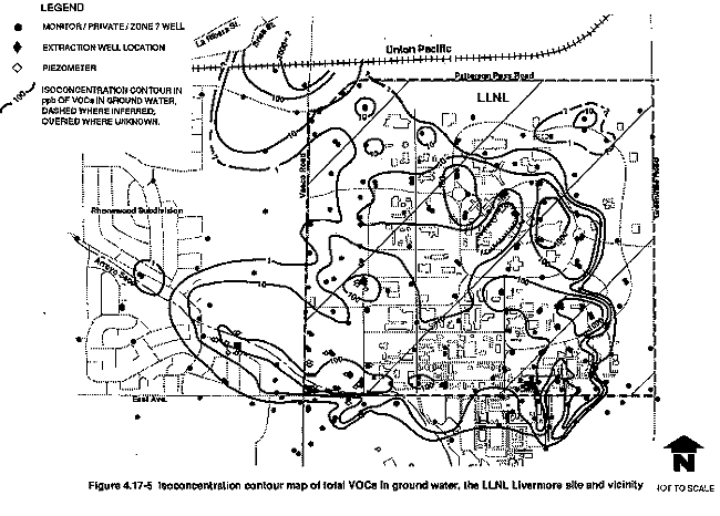
Volatile organic compounds occur in ground water beneath about 85 percent of the 1.4-square-mile LLNL Livermore site. Several overlapping smaller plumes, each with separate origins, make up the large composite plume. The largest of these is a plume about 4000 ft long and 2500 ft wide, the leading edge of which has migrated about 2500 ft west of Vasco Road from a release point in the southwest area.
The highest concentration of total volatile organic compounds detected in ground water samples collected in February 1991 was 5808 ppb, in the southeastern part of the LLNL Livermore site. Total volatile organic compound concentrations exceed 1000 ppb in three other areas: west of the East Traffic Circle Area, the Eastern Landing Mat Area Taxi Strip Area, and northwest of the LLNL Livermore site (north of the Patterson Pass–Vasco Road intersection), where 2700 ppb of trichloroethylene was reported in March 1991 (Iovenitti et al., 1991). Existing data suggests the source of the volatile organic compound contamination in the northwest corner of the LLNL Livermore site is located offsite (Dresen et al., 1991). Total volatile organic compounds exceed 1000 ppb in only 8 out of 324 LLNL-sampled monitor wells (Dresen et al., 1991).
Other than in the immediate vicinities of the 1000-ppb "hot spots" (see Figure 4.17-5), total volatile organic compound concentrations in excess of 100 ppb occur in the western part of the LLNL Livermore site, in the southwest corner, in the West Traffic Circle Area, and in the southeast corner near Building 518.
Horizontal Distribution of Individual Volatile Organic Compounds
Volatile organic compounds occur in ground water beneath about 85 percent of the 1.4-sq-mi LLNL Livermore site in diffuse plumes. However, the calculated volume of volatile organic compounds in the ground water is less than 200 gal (Isherwood et al., 1990).
Trichloroethylene, the most common volatile organic compound at the LLNL Livermore site, is present in 158 of 259 monitor wells, and is found in concentrations up to 4800 ppb (Thorpe et al., 1990). This concentration is the highest recently detected for any single volatile organic compound (excluding fuel hydrocarbons) at the LLNL Livermore site. Trichloroethylene is migrating west of the LLNL Livermore site from the southwest corner and west-central areas.
Perchloroethylene plumes occur in the eastern part of the LLNL Livermore site and in the southwest corner and offsite area. In addition, several other small, low-concentration perchloroethylene plumes occur in the study area (Thorpe et al., 1990).
There are at least two overlapping perchloroethylene plumes in the eastern part of the LLNL Livermore site. The highest concentration of perchloroethylene in ground water occurs in the Landing Mat Storage Area and in the southwest corner of the LLNL Livermore site. The persistence of perchloroethylene near the suspected release site may result from the relatively high sorptive capacity of fine-grained sediments. Perchloroethylene has migrated about 4000 ft west-northwest from the southwest corner of the LLNL Livermore site, generally following Arroyo Seco. Plumes with concentrations exceeding 100 ppb extend about 3300 ft northwest and show a strong alignment with Arroyo Seco, reflecting the prevalent ground water flow direction. Former discharges from storm sewers into Arroyo Seco were probably the major source of perchloroethylene, which is found in concentrations as high as 97 ppb in unsaturated soil at the Arroyo Seco storm sewer discharge area (Thorpe et al., 1990).
Vertical Distribution of Volatile Organic Compounds
In the saturated zone, downward vertical gradients exist over much of the site; however, the lithologic conditions prevent significant downward migration of volatile organic compounds (Isherwood et al., 1990).
Soil borings were drilled in areas of high (typically greater than 100 ppm) soil vapor total volatile organic compound concentrations. Sediment samples were collected at 10-ft increments down to the saturated zone (Thorpe et al., 1990). Total volatile organic compound concentrations exceeding 1 ppm in unsaturated sediment occur only near Building 518, in the southeast corner of the LLNL Livermore site, where a total volatile organic compound concentration of 6 ppm was measured at a depth of about 20 ft (Isherwood et al., 1990). Unsaturated zone total volatile organic compound concentrations from other potential source areas ranged from below 5 ppb to below 500 ppb. However, total volatile organic compound concentrations up to 800 ppb were reported for the unsaturated zone beneath the East Traffic Circle Area (Isherwood et al., 1990).
Of the 325 LLNL monitor wells and piezometers, only 10 are completed below a depth of 200 ft although many were drilled deeper for sampling purposes and then grouted back to shallower depths. Of these 10, only 3 wells contain volatile organic compounds: one in the Southeast Corner Area and two on DOE property southeast of the Vasco Road–East Avenue intersection. In these three wells, only the monitor well located near the Vasco Road–East Avenue intersection (MW-462) contained perchloroethylene in excess of the maximum contaminant level, with a concentration of 13 ppb. Here, perchloroethylene and 1,1-dichloroethylene were detected above the maximum contaminant levels at depths between 331 and 336.5 ft.
At greater distances from the sources, volatile organic compounds are limited to the more permeable deposits, which generally contain higher concentrations, and to some of the fine-grained sediments next to the coarse sediments. The plumes are about 30 ft to 100 ft thick, and volatile organic compounds are seldom found below a depth of 200 ft (Thorpe et al., 1990). Existing data indicate that beginning several hundred feet downgradient from the contaminant plume source area, volatile organic compounds do not extend into the fine-grained sediments more than about 5 ft from the coarser, more permeable layers. This is consistent with transport dominated by advection (volatile organic compound migration by the bulk flow of ground water) in the higher permeability sediments. Diffusion appears to play a secondary role in volatile organic compound transport at LLNL. Specifically, these preliminary data suggest that diffusion is responsible for vertical migration on the order of tens of feet in the offsite perchloroethylene plume. In the same plume, constituents are dispersed horizontally for hundreds of feet.
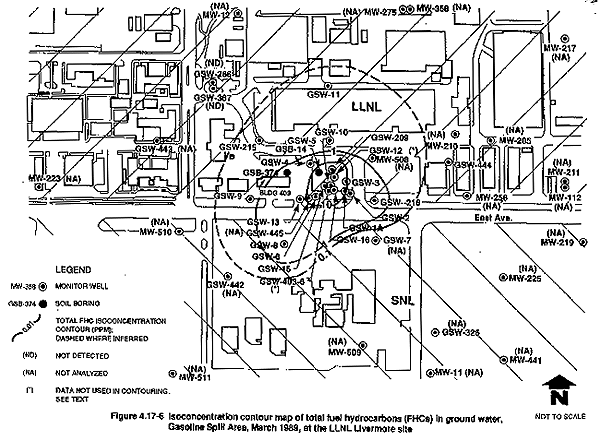
Fuel Hydrocarbon Compounds (FHCs) in Ground Water
Ground water samples from over 300 monitor wells, piezometers, and private wells have been analyzed for fuel hydrocarbon compounds including gasoline, diesel, some fuel oils, and aromatic hydrocarbons (benzene, toluene, ethylbenzene, and xylene). These analyses show that fuel hydrocarbon compounds are generally restricted to the Gasoline Spill Area in the south central area of the LLNL Livermore site.
Ground water from three monitor wells outside the Gasoline Spill Area was reported to contain benzene at concentrations up to 4.0 ppb, which is greater than the 1.0 ppb maximum contaminant level. Subsequent sampling in two of these monitor wells revealed no detectable benzene concentrations. Similarly, no benzene has been reported for the remaining monitor wells outside the Gasoline Spill Area. Toluene, total xylenes, and ethylbenzene, above their action levels of 100 ppb, 1750 ppb, and 680 ppb, respectively, were not detected in ground water outside the Gasoline Spill Area.
In the Gasoline Spill Area, total fuel hydrocarbons occur at concentrations of 1.0 ppb to approximately 300 ft from Building 403 (Figure 4.17-6). Total fuel hydrocarbon concentrations exceeding 10 ppm are restricted to the immediate vicinity of the gasoline leak point (see Figure 4.17-6) just southeast of Building 403 (Thorpe et al., 1990). Ground water concentrations of benzene, toluene, ethylbenzene, and xylene in the Gasoline Spill Area between 10 and 100 ppm are restricted to a small area near the probable gasoline leak point. Total benzene, toluene, ethylbenzene, and xylene ground water concentrations between 1.0 ppm and 10 ppm extend up to 300 ft away from the leak point. The vertical extent of fuel hydrocarbons and benzene, toluene, ethylbenzene, and xylene in ground water was investigated by sampling three deeper monitor wells in the Gasoline Spill Area at intervals greater than 155 ft. Ground water samples from these monitor wells identified fuel hydrocarbons and benzene, toluene, ethylbenzene, and xylene compounds below maximum contaminant or action levels (Thorpe et al., 1990).
Trace Elements in Ground Water
Total chromium was detected above maximum contaminant levels (see Tables 4.17-8 and 4.17-9). Total chromium concentrations exceed the maximum contaminant level (50 ppb) in 16 wells (Dresen et al., 1991), as shown in Figure 4.17-7. Evidence suggests that some chromium occurs naturally in the LLNL area; however, additional chromium (in the hexavalent state) may have entered the ground water from discharges of corrosion inhibitors and biocides used in the early 1970s in cooling-tower piping. Of the onsite monitor wells containing chromium above the California drinking water standard, four are near a north-flowing drainage channel east of the West Traffic Circle (see Figure 4.17-1). One additional well is located in the southeast corner of the LLNL Livermore site, close to a storm sewer around the perimeter of Building 511 that may have received blowdown water from the cooling tower at that facility.
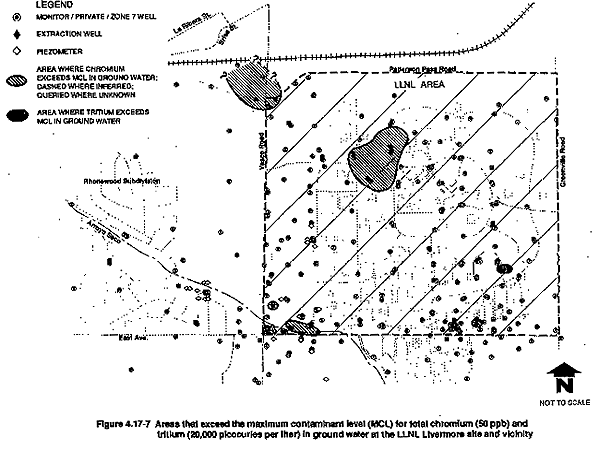
Although data are limited, four other trace elements—barium, cadmium, selenium, and silver— possibly exceed maximum contaminant levels. Of these, cadmium and selenium have occurred above the maximum contaminant level only once. The four metals, to a very limited extent, exist in LLNL Livermore site area ground water (see Table 4.11-2) and are probably not the result of present or past LLNL activities. Two additional trace metals (iron and manganese) occur at levels above EPA secondary drinking water standards. These metals, natural constituents of most ground water, do not appear to be related to present or past LLNL activities. Lead concentrations exceeded the maximum contaminant level in two monitor wells, both in the Gasoline Spill Area where leaded gasoline leaked. Recent analyses show lead below the maximum contaminant level.
Radionuclides in Ground Water
Since 1984, ground water from 187 wells has been analyzed for radionuclides. Gamma emission measurements for ground water samples from 38 wells from 1984 to 1988 indicated no gamma-emitting radionuclides above background levels. Tritium is the only radionuclide present in ground water in concentrations that exceed regulatory limits (LLNL, 1990c).
Tritium contamination greater than the maximum contaminant level of 20,000 pCi/L for tritium has been detected in only two monitor wells, both located in the southeast quadrant of the LLNL Livermore site. Boreholes in that area have measured tritium activities as high as 105,000 pCi/L. Currently, tritium activities in water samples from only one of these wells (MW-206) located in the East Taxi Strip Area exceed the tritium maximum contaminant level (see Figure 4.17-7) (Dresen et al., 1991). The source of this tritium was apparently leakage from one of the former evaporation ponds in the East Taxi Strip waste storage area (Buerer, 1983).
Tritium has been detected at activities as high as 7700 pCi/L in ground water near an underground tank leak near Building 292. To date, all ground water samples collected near Building 292 have tritium activities below 20,000 pCi/L (Dresen et al., 1991).
Polychlorinated Biphenyls and Pesticides in Ground Water
No polychlorinated biphenyls or pesticides have been detected in ground water at LLNL, Livermore. From 1984 to 1989, ground water from 153 monitoring and private wells were analyzed for polychlorinated biphenyls and pesticides using EPA methods with detection limits ranging from 0.05 to 1.0 ppb. Although transformers containing polychlorinated biphenyls were buried in the former East Traffic Circle Landfill, these were removed during the excavation and cleanup of that area, and no polychlorinated biphenyls have been detected in LLNL ground water.
Table 4.17-8 Summary of Potential and Detected Ground Water Contaminants at the LLNL Livermore Site
| Areas Investigatedb | Potential Ground Water Contaminanta | Water Contaminants Detected at Concentrations or Activities Above Maximum Contaminant Level | ||||
| VOC | FHC | Metals | PCB | Rad | ||
| Arroyo Seco Storm Sewer Discharge Area (1) | Y | Y | Y | Y | Y | VOC: CCl4, 1,1-DCA, 1,1-DCE, 1,2-DCE,
PCE, TCE Metal: chromium |
| Building 212 Area (2) | Y | Y | Y | Y | Y | VOC: CCl4, 1,1-DCA, 1,1-DCE, PCE, TCE, 1,2-DCA |
| Building 321 Area (3) | Y | Y | Y | N | Y | VOC: TCE, PCE, 1,1-DCE, CCl4 |
| Building 141 Area (4) | Y | Y | Y | N | Y | VOC: CCl4, PCE, TCE |
| West Traffic Circle Area (5) | Y | N | Y | N | Y | VOC: chloroform, 1,1-DCE, TCE, 1,2-DCE,
Metal: chromium |
| East Traffic Circle Area (6) | Y | Y | Y | Y | Y | VOC: CCl4, chloroform, 1,1-DCA, 1,2-DCA, 1,1-DCE, 1,2-DCE, TCE, PCE |
| Taxi Strip (7) | Y | Y | Y | N | Y | VOC: CCl4, chloroform,
1,1-DCA, 1,2-DCA, 1,1-DCE, PCE, TCE Rad: tritium |
| Eastern Landing Mat Storage Area (8) | Y | Y | Y | Y | Y | VOC: 1,1-DCA, 1,1-DCE, 1,2-DCE, PCE, 1,1,1-TCA, TCE |
| Old Salvage Yard (9) | Y | Y | Y | N | N | VOC: CCl4, 1,2-DCA, 1,1-DCE, 1,2-DCE, PCE, TCE |
| Building 612 Area (10) | Y | N | Y | N | Y | VOC: CCl4, 1,1-DCE, TCE |
| Building 514 Area (11) | Y | Y | Y | N | Y | VOC: CCl4, 1,1-DCA, 1,2-DCA, 1,1-DCE, 1,2-DCE, PCE, TCE |
| Building 518 Area (12) | Y | Y | N | N | N | VOC: CCl4, 1,1-DCE, 1,2-DCE, PCE, TCE |
| Building 298 Area (13) | Y | Y | N | N | N | VOC: 1,1-DCE, TCE |
| Building 361 Area (14) | Y | Y | N | N | N | VOC: 1,1-DCE, TCE |
| Gasoline Spill Area (15) | Y | Y | Y | N | N | VOC: 1,2-DCE, 1,2-DCA, ethylene
dibromide, CCl4
Metal: cadmium FHC: B, T, E, X |
| Building 292 Area (16) | N | N | N | N | Y | None identified |
| Building 331 Area (17) | N | N | N | N | Y | Rad: tritium |
| Y = Potential soil contaminant N = Not a potential soil contaminant VOC = Volatile organic compound FHC = Fuel hydrocarbon constituent PCB = Polychlorinated biphenyls Rad = Radiological constituent CCl4= Carbon tetrachloride 1,1-DCA = 1,1-Dichloroethane 1,2-DCA = 1,2-Dichloroethane |
1,1-DCE = 1,1-Dichloroethene 1,2-DCE = 1,2-Dichloroethene 1,1,1-TCA= 1,1,1-Trichloroethene PCE = Tetrachloroethene (perchloroethylene) TCE = Trichloroethene (trichloroethylene) B = Benzene T = Toluene E = Ethylbenzene X = Xylene |
a Based upon known or suspected releases
or hazardous materials use, storage, or disposal practices strongly suggestive
of potential release(s).
b See Figure 4.17-1 for area
numbers.
Table 4.17-9 MCLs and State Discharge Limits for Compounds of Concern in Ground Water at the LLNL Livermore Site
| Concentration Limit for Drinking Watera | |||||
| Constituent | Non-zero Federal MCLG (ppb) | Federal MCL (ppb) | CA MCL (ppb) | Concentration range at LLNL March 1990—1991 (ppb) | Discharge Limit for Treated Water |
| PCE | --- | 5c | 5 | <0.1–1,050 | 4 |
| TCE | --- | 5 | 5 | <0.1–4,800 | 5 |
| 1,1-DCE | 7 | 7 | 6 | <0.5–370 | 5 |
| cis-1,2-DCE | 70c | 70c | 6 | <0.5–24 | 5 (total 1,2-DCE) |
| trans-1,2-DCE | 100c | 100c | 10 | <0.5–1 | 5 (total 1,2-DCE) |
| 1,1-DCA | --- | --- | 5 | <0.5–60 | 5 |
| 1,2-DCA | --- | 5 | 0.5 | <0.1–190 | 5 |
| Carbon tetrachloride | --- | 5 | 0.5 | <0.1–91 | 5 |
| Total THMd | --- | 100d | 100d | <0.5–270 | 5 |
| Benzene | --- | 5 | 1.0e | <0.1–4,600 | 0.7 |
| Ethyl benzene | --- | 700 | 680 | <0.2–610 | 5 |
| Toluene | 2,000c | 1,000c | 100c,f | <0.5–4,200 | 5 |
| Xylenes (total) | 10,000c | 10,000c | 1,750g | <0.5–3,700 | 5 |
| Ethylene dibromide | --- | 0.05c | 0.02 | <0.1–51 | 5 |
| Total VOCs | --- | --- | --- | up to 5,808 | 5 |
| Chromium+3h | 100c (total) | 50h (total) | 50 (total) | <5–150 (total) | 50 (total Cr) |
| Chromium+6h | 100c (total) | 50h (total) | 50 (total) | <10–140 | 11 |
| Lead | --- | 15i | 50 | <2–10 | 5.6 |
| Tritiumj | --- | 20,000 pCi/L | 20,000 pCi/L | <200–33,100 pCi/L | ---k |
a Human receptor. The limits on this
table were established through negotiations with regulatory agencies and will be
in full effect for 5 years. After 5 years LLNL will comply with the most
stringent MCL requirements.
b From NPDES Permit No. CA0029289
(revised 8/1/90) and RWQCB Order No. 90-106. VOC-specific state discharge limits
exist in RWQCB Order No. 90-106 only for PCE (4 ppb) and benzene (0.7 ppb).
Other VOCs listed in this table are included in the 5 ppb total VOC limit.
Discharge limits for metals differ slightly according to discharge location.
c These are proposed values, which
means they are not enforceable by law.
d Total trihalomethanes; includes
chloroform, bromoform, chlorodibromomethane, and bromodichloromethane.
e The DTSC AAL for benzene is 0.2
ppb.
f California Department of Health
Services Action Level.
g MCL is for either a single isomer
or the sum of the ortho, meta, and para isomers.
h National Interim Primary Drinking
Water Regulation for total chromium is 50 ppb.
i
National Primary Drinking Water Regulation Enforceable Action Level (Federal
Register, volume 56, number 110, June 7, 1991.
j Thorpe et al., 1990, show that
ground water in the one well that currently exceeds the tritium MCL will be
naturally remediated long before it migrates offsite.
k There is currently no NPDES discharge limit for
tritium. LLNL will use the MCL for tritium as the discharge limit.
Note: Because non-zero Federal MCLGs (Maximum Contaminant Level
Goals) are equal to Federal MCLs in all cases above, these are referred to
simply as MCLs throughout this document.
Source: Dresen et al., 1991
4.17.2.4 Site Characterization and Remediation Efforts
Geologic, seismologic, and hydrologic investigations were initiated as early as 1979 at the LLNL Livermore site and nearby areas. Since that time, numerous reports have documented the results of ongoing investigations. Based upon these investigations, remediation activities have been implemented. Examples of such investigations are as follows:
- In 1979, a fuel leak was discovered in the area of Building 403, the Gasoline Spill Area, in the southern part of the LLNL Livermore site. In 1985, this was the subject of several reports. These reports discussed investigations into the fuel leak and possible remedial actions. Additionally, wells west of the site were evaluated to determine whether any interaquifer cross-connection existed (Dresen and McConachie, 1986). To evaluate the integrity of underground tanks onsite, the tanks were tested, and findings were reported (Henry et al., 1986).
- In 1982, a hydrogeologic investigation to determine the likelihood of contaminant movement to the saturated zone from near the ground surface at the LLNL Livermore site was completed (Stone et al., 1982). The investigation included a survey of potential contaminant sources and identified several potential sources. The study concluded that the migration of contaminants from the vadose zone to the saturated zone beneath the site was likely.
- In 1983, documentation of the assessment and cleanup in the Taxi Strip waste storage area (see Figure 4.17-1) was prepared (Buerer, 1983). The earlier work of Stone et al. (1982) was extended by further evaluation of the potential for ground water contamination (Stone and Ruggieri, 1983).
- In 1987, reports evaluated possible releases of volatile organic compounds to ground water from the following areas: the Taxi Strip and Old Salvage Yard areas, the Southwest Corner and the Arroyo Seco area, and the remainder of the site (Webster-Scholten et al., 1987).
- Twenty-three wells historically affected by or potentially affected by the contaminant plume(s) were taken out of service. Some of the properties containing the wells were acquired by DOE in 1987. In other cases, affected residences were connected to the municipal water system by LLNL. The wells were permanently sealed between 1984 and 1989 to eliminate the potential for the wells to act as conduits for the migration of contaminants (Thorpe et al., 1990).
- In 1988, a proposal was prepared to conduct pilot ground water and soil vapor extraction and treatment in the Gasoline Spill Area (Nichols et al., 1988). This proposal evaluated potential remediation strategies for cleanup of the gasoline leak. Qualheim (1988) provided a compilation of all hydrogeologic well logs prepared through 1987 for the Ground Water Project.
Soil and ground water monitoring continue to the present, and two pilot studies are being conducted in the southwestern corner of the LLNL Livermore site and gasoline spill areas (Isherwood et al., 1990).
The Remedial Investigation (Thorpe et al., 1990) performed at the LLNL Livermore site characterized the contamination at each potential source area and throughout the ground water underlying LLNL (DOE, 1989c). For the Remedial Investigation, source characterization included the onsite and offsite areas identified in the Federal Facility Agreement, but ground water investigations were performed sitewide. LLNL prepared a feasibility study to evaluate and select alternative technologies for remediation of hazardous materials in the LLNL Livermore site subsurface (Isherwood et al., 1990). The Feasibility Study (Isherwood et al., 1990), and more recently the Proposed Remedial Action Plan (Dresen et al., 1991), summarize the recommended alternatives to the LLNL Livermore site sediment and ground water remediation.
Table 4.17-10 identifies the schedule of tasks and compliance dates associated with the LLNL Livermore site remediation. The schedule has been periodically renegotiated based on changing needs and requirements. As of June 1991, the following environmental restoration activities had taken place (LLNL, 1991f; Dresen et al., 1991):
- Taxi Strip Impoundments—Removed soil and cleaned up area.
- East Traffic Circle Landfill—Removed waste and cleaned up area.
- Polychlorinated biphenyls–Containing Units—Remedied affected areas, removing 11 transformers, 12 capacitors, and miscellaneous switch gear.
- Leaking Tanks—Removed 17 tanks and cleaned up affected areas.
- Community Relations Plan—Submitted final plan to regulatory agencies.
- Community Relations Group—Established work group with regularly scheduled meetings and a quarterly publication to keep members informed.
- Quality Assurance Project Plan—Submitted final plan to regulatory agencies.
- Work Plan for Remedial Investigation/Feasibility Study—Submitted final plan to regulatory agencies.
- Baseline Public Health Assessment—Submitted report to regulatory agencies.
- Southwest/Offsite Areas and Gasoline Spill Area—Began Pilot Studies.
- Potential Conduit Wells—Destroyed and sealed 19 wells to prevent vertical migration of contaminants.
- Remedial Investigation Report—Submitted final report to regulatory agencies.
- Installed Monitor Wells—More than 300 wells drilled, sampled, and flow-tested.
- Feasibility Study Report—Submitted draft of final report to regulatory agencies.
- Pilot Studies—Two treatment facilities have been installed to remove volatile organic compounds from the ground water using an ultraviolet-light/hydrogen-peroxide system to oxidize halogenated hydrocarbons. Gas venting system installed to remove hydrocarbons from the unsaturated zone at the Gasoline Spill Area.
- Draft Proposed Remedial Action Plan—Submitted to regulatory agencies.
Additionally, quarterly ground water quality assessments have been performed since 1983. As a result, all tasks identified in the Federal Facility Agreement have been performed, or documentation has been submitted in draft form on schedule. Full remedial actions are pending following public and regulatory reviews, and are expected to be phased in over 2 to 3 years.
Table 4.17-10 Schedule of Tasks, Compliance Dates, and Reports Documenting Environmental Compliance at the LLNL Livermore Site
| Document | Deadlines/Target Dates |
| RI/FS Work Plana | Draft submitted 10/28/88
Final submitted 5/8/89 |
| Quality Assurance Project Plana | Draft submitted 5/25/88
Final submitted 1/11/89 |
| Community Relations Plana | Draft submitted 10/26/88
Final submitted 5/12/89 |
| Remedial Investigation Reporta | Draft submitted 12/1/89
Final submitted 3/14/90 |
| Feasibility Study Reporta | Draft submitted 8/1/90 Final submitted 12/17/90 |
| Proposed Remedial Action Plana | Draft Final submitted 6/24/91 |
| Record of Decisiona | 3/1/92 |
| Remedial Action Implementation Plana | 10/1/92 |
| Remedial Designa | 6/1/92 |
| Baseline Public Health Risk Assessmentb | Draft submitted 6/15/89
Final submitted in Remedial Investigation Report 3/14/90 |
| Monthly Reports | Monthly, within 30 days of the end of the reporting period |
| Annual Reports | Annually, by January 31 of the following year |
a Source document.
b Secondary document.
Source: Isherwood et al., 1990; updated 8/2/91.
4.17.2.5 Proposed Remedial Actions and Potential Impacts of Remediation
Several approaches to cleaning up ground water and unsaturated sediment contamination were evaluated in the Feasibility Study (Isherwood et al., 1990) and in the Proposed Remedial Action Plan (Dresen et al., 1991). The reports present viable cleanup options for the types of contamination in different parts of the site. The Remedial Investigation (Thorpe et al., 1990), Feasibility Study (Isherwood, 1990), and Proposed Remedial Action Plan (Dresen et al., 1991) are being submitted as an Environmental Assessment (EA) under NEPA in accordance with DOE's NEPA/CERCLA integration procedures.
Proposed Remedial Actions
LLNL and DOE believe that the following alternatives best meet the criteria established by the EPA:
- Ground water extraction at 18 locations throughout the contaminated area, including source areas, to stop further contaminant migration and achieve the shortest cleanup schedule. Ground water would be treated at seven treatment facilities, four of which would use ultraviolet light and oxidation as the primary treatment process. The remainder would use air stripping as the primary treatment process. Treated water would be returned to the subsurface or used at the LLNL Livermore site. After approximately 50 years, residual ground water contaminants would be reduced to levels below maximum contaminant levels. The present-worth cost of this alternative is estimated to be $103 million.(3)
- Vacuum-induced vapor withdrawal from the unsaturated zone with surface treatment of vapors by thermal or catalytic oxidation (Building 518 Area, Gasoline Spill Area). Cleanup of unsaturated sediment would be complete in about 10 years. The present-worth cost of this alternative is $1.84 million.
All extraction wells and treatment facilities, except one proposed extraction location in the Rhonewood subdivision area west of the LLNL Livermore site, would be located on LLNL property and would result in little or no impact to the neighboring community. This extraction alternative would involve pumping and treating at a combined rate of about 360 gals per minute. Extracted ground water would be piped in double-walled pipe to one of the treatment facilities, and then to one or more of the following:
- Existing recharge basin at SNL, Livermore
- Drainage retention basin at the LLNL Livermore site
- Recharge well network
- Storm drainage ditches
- Cooling towers
LLNL is currently conducting two EPA-approved pilot studies within the context of the CERCLA processes (Isherwood et al., 1990). The Offsite Pilot Study located in the Southwest corner of the LLNL Livermore site is evaluating the effectiveness of a test extraction well design, an ultraviolet light/hydrogen peroxide (UV/H2O2) water treatment system, and a basin to recharge treated ground water. The Gasoline Spill Pilot Study, in the southern part of the LLNL Livermore site, is currently evaluating the feasibility of venting and treating fuel hydrocarbon compounds (i.e., gasoline) from the unsaturated zone, and from a portion of the saturated zone after it is dewatered. The pilot studies have played an integral role in assessing the effectiveness of the various remedial strategies and have accelerated the timetable for beginning remedial action. Over 32 million gal of ground water have been extracted and treated to date, resulting in significant declines in volatile organic compound concentrations in source areas.
Environmental Impacts of Remediation
Ground water
As a result of the recommended pump and treat method, the volatile organic compound plume will be intercepted and cleaned up to applicable or relevant and appropriate requirements, eventually allowing ground water already affected to be remediated and preventing loss of ground water beneficial uses elsewhere. The recommended alternative expedites ground water remediation by situating extraction wells in all areas of high volatile organic compound concentration, as well as at plume margins, thereby minimizing the time necessary to complete remediation.
For areas in which both volatile organic compounds and tritium occur above maximum contaminant levels in ground water (such as in the East Taxi Strip Area), volatile organic compounds would be reduced below discharge limits through the proposed extraction treatment alternative. LLNL plans to design the extraction systems to prevent tritium concentrations above the maximum contaminant level from exiting the treatment system.
In order to mitigate potential releases of tritium to the environment from a ground water treatment plant, LLNL will shut down any treatment system if discharges to the environment exceed the maximum contaminant levels for tritium. Similarly, LLNL Livermore will shut down any treatment system that emits tritium to the atmosphere at a rate predicted to cause exposure of greater than 10 millirem (mrem) per year according to the Federal Standard in the Clean Air Act (Dresen et al., 1991). Water vapor containing tritium extracted from affected unsaturated soils would be separated by condensation, and if the condensate were to exceed the maximum contaminant levels for tritium, it would be disposed of appropriately (Dresen et al., 1991).
Proposed methods of disposal of treated water would beneficially use most of the treated ground water through recharge basins, wells, surface water, channels, or landscape irrigation. In 1988, LLNL constructed a recharge basin south of East Avenue on DOE property to investigate the feasibility of conserving the local ground water resource by surface recharge. The recharge basin has performed very effectively, with an estimated 92 to 98 percent of the treated water recharged. Over 12.5 million gal of treated water have been discharged to the recharge basin (Isherwood et al., 1990). The potential effects of water level decline during the long-term pumping (e.g., from 18 extraction wells and from local agricultural and domestic wells) are currently being evaluated using the ground water computer code CFEST. Results of these modeling efforts are pending.
Proposed surface discharge points at the LLNL Livermore site include a ditch running northward along Vasco Road, which drains to Arroyo Las Positas, and the Drainage Retention Basin located in the center of the LLNL Livermore site. Although increased flow would occur from the LLNL Livermore site into Arroyo Las Positas, most of the water is expected to infiltrate the floor of the Arroyo within 1000 ft of the discharge point (Dresen et al., 1991). Water discharged to the surface during the rainy season may increase flows in local drainage channels. Such increased flows would likely be minor, but they could result in increased intermittent flow to Arroyo Seco and Arroyo Las Positas. Minor adverse impacts could occur to the ground water resource and to wetland habitats and associated biota as a result of either surface water quality degradation or flooding.
Water will be tested before release to surface water as prescribed for the LLNL Livermore site by NPDES permits and Regional Water Quality Control Board waste discharge requirements. Use of treated ground water for irrigation, and perhaps for release to downstream habitats, may require some dilution of salts. In order to mitigate this potential secondary impact, some mixing of treated ground water with runoff water could be required (i.e., Hetch Hetchy water) (Isherwood et al., 1990).
Monitoring of all surface water bodies at LLNL Livermore site and vicinity, including seeps, springs, lakes, retention ponds, streams, and ditches, will continue under the environmental restoration and environmental protection monitoring programs. The surface water samples are currently analyzed for gross alpha and beta radiation, tritium, and nonradioactive pollutants including various solvents, metals, and pesticides (see section 4.11).
In order to assure that no adverse impacts would occur due to recharge activities, proposed recharge locations have been selected away from known unsaturated zone contamination. They are in areas remote from septic tanks, leachfields, basements, and agricultural operations and at strategic locations with respect to proposed extraction well fields. Water levels will continue to be monitored in recharge areas to assist in determining allowable pumping and recharge volumes.
In addition to the ongoing water level monitoring programs at the LLNL Livermore site and in the vicinity, the Alameda County Flood Control and Conservation District Zone 7 currently monitors both water quality and levels in wells upgradient and downgradient of the LLNL Livermore site, thereby providing an additional means for evaluating any local adverse impacts to the eastern Livermore ground water basin.
Extraction of ground water will cause local aquifer drawdown in the areas surrounding the extraction wells (Isherwood et al., 1990). The magnitude of the impact to local and regional water level conditions is currently not known; however, based on the total estimated flow for proposed ground water extraction programs (Isherwood et al., 1990) and estimates of ground water use in the LLNL Livermore site area, it is unlikely that municipal water supply wells would be impacted (see section 4.19). Local existing water supply wells that are screened above 200 ft could be significantly impacted in the southwest portions of the LLNL Livermore site. Furthermore, individual wells could be affected locally by one or more extraction wells because of interfering cones of influence. Additionally, the effect of remedial pumping on water quality in local water supply wells as a result of long-term pumping is not fully known. Recently, modeling efforts by LLNL indicate that drawdown in local wells may be as much as 10 ft; additional modeling of potential drawdown effects is currently in progress (Dresen et al., 1991).
Water levels in the vicinity of the LLNL site continue to decline as a result of drought conditions. Cumulative impacts could result from the combined additive effect of water level declines due to drought conditions, from remedial ground water extraction and from local domestic or agricultural pumping. Lower water levels could further limit the effectiveness of remedial pumping by extending the time required for cleanup, particularly if further development of irrigation water sources occurs, such as south of East Avenue.
Excessive ground water pumping that causes lowered ground water levels could potentially result in the consolidation of dewatered sediments and consequent land subsidence. Unlike the subsidence problems noted in the San Joaquin and Santa Clara valleys, where over 10 ft of subsidence has been observed, subsidence from ground water withdrawal has not been noted to be a problem in the Livermore-Amador Valley area (WESCO, 1988). Therefore, land subsidence due to pumping is unlikely.
Soils
Vacuum-induced soil venting coupled with air monitoring and continued ground water monitoring is the preferred remedial action alternative at the Building 518 and Gasoline Spill Area. Soil gas extraction would greatly reduce the levels of volatile organic compounds in the soil, thereby reducing the potential for future ground water contamination. This alternative involves installing a soil gas extraction system in the soil contaminated area to remove volatile organic compounds and fuel hydrocarbon compounds. Extracted volatile organic compounds in the gaseous phase will be monitored to ensure compliance with air emission requirements. Fuel hydrocarbons in the gaseous phase would be catalytically oxidized.
No impacts to human health are anticipated from the gaseous release of volatile compounds to health-based or environmental regulatory standards. The potential health hazard due to accidental emissions is minimal. Onsite air monitoring will ensure that no health risks occur during the remediation. Granular activated carbon would be generated during the soil gas removal program that would be required to be removed to an offsite treatment storage and disposal facility.
Installation of soil vapor extraction wells would result in a minor disruption and replacement of soil, which is not considered significant. Automatic shut-off mechanisms would be installed on the system if an accidental release were to occur. Vacuum pumps that would be used for vapor extraction might generate noise levels to approximately 70 dBA. However, these pumps would be housed in buildings that would muffle this noise to below 50 dBA. Noise is not considered a significant impact.
Each impact would have a minor cumulative effect that would be added to this already industrialized site. All air permitting requirements would be followed to ensure that no significant impact to the environment would occur. Additionally, all other contributions to impacts are considered not significant.
4.17.3 Site Contamination-LLNL Site 300
4.17.3.1 Contamination History
Historic Use of Hazardous Materials
LLNL Site 300 consists of a General Services Area and a variety of facilities used for high explosives formulating, manufacturing, and testing. Hazardous materials have been used in the formulation and processing of explosives; hazardous and nonfissile radioactive materials (radioactive materials that will not undergo fission when bombarded with slow neutrons) have been included in explosive components that are tested. Solid wastes from detonation of test assemblies are the principal source of radioactive or hazardous wastes. Until November 1988, the bulk of this waste was classified as mixed radioactive waste (see section 4.15). Some of the test assemblies have contained materials such as depleted uranium, thorium, and tritium; and toxic materials such as lead, beryllium, barium, copper, and vanadium.
In the past, liquid waste including high explosive fines, solvents, and metals was discharged into unlined evaporation ponds in the High Explosives Process Area. This practice was terminated in 1985. Trichloroethylene was used as a heat transfer fluid at active test facilities such as the Building 834 Complex. Both trichloroethylene and perchloroethylene were used at a number of General Services Area facilities. Trichloroethylene was used at the Advanced Test Accelerator Facility as a cleaning solvent and as a component of insulating oil. Freon-113 was used as a degreaser. A chemical-waste retention system is provided for chemical operation areas of the High Explosive Process Area. All chemical laboratories are connected to two central, above ground waste retention tanks. All drain lines between the buildings and these tanks are above ground. The tanks are surrounded by a berm capable of containing the volume of both tanks (Santos and Landau, 1987).
4.17.3.2 Contamination Sites, Remediation Efforts, and Potential Impacts of Remediation
Since 1981, a number of site-specific environmental assessment studies focusing on soil and ground water contamination and investigation of potential source areas have been conducted at LLNL Site 300 (see Figure 4.17-8). Soil contaminants and their distribution were identified based upon potential source area investigations. Soil contaminants identified include volatile organic compounds, fuels, aromatic hydrocarbons, metals, radionuclides, and high-explosive compounds (see Table 4.17-11). Reported soil contaminant concentrations are summarized in Table 4.17-12.
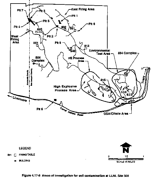
Since 1956, 20 water supply wells have been drilled at LLNL Site 300. By 1990, eight of the wells were removed from service in response to either the presence of contaminated ground water or concerns about cross contamination. Currently, six water supply wells (three onsite and three offsite) are being monitored for potential contamination (Lamarre, 1990) (see Figure 4.11-9).
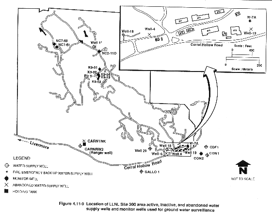
Ground water has been impacted to varying degrees at over six areas at LLNL Site 300 (see Figure 4.17-9) that are currently under various stages of investigation and/or remediation. Contaminants include volatile organic compounds (trichloroethylene, perchloroethylene, 1,2-DCE, Freon-113, and chloroform), high explosives RDX (cyclo-1,3,5-trimethylene-2, 4, 6-trinitrimine) and HMX (cyclotetramethylenetetranitramine), and tritium. The most significant ground water impacts at LLNL Site 300 are from chlorinated solvents, particularly trichloroethylene. Investigations of trichloroethylene contamination have focused on the General Services Area, the Building 834 Complex, and Building 815. In addition, trichloroethylene contamination has been identified in ground water near the Pit 7 Complex, and at Pit 6 and Pit 8 (Lamarre, 1989).
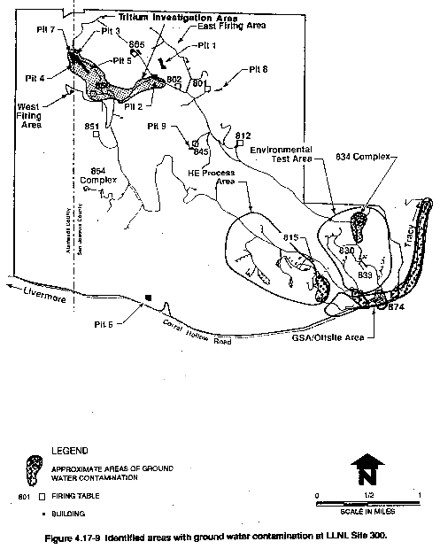
At present there are seven remedial investigation/feasibility study actions being conducted at LLNL Site 300, including the Building 833 Area, the Pit 6 Landfill Area, the High Explosive Process Area, the General Services Area, the Pit 7 Complex, the Building 834 Complex, and the Building 850/East Firing Area. For purposes of this EIR/EIS the Building 834 Complex and Building 833 Area are referred to as the Environmental Test Area. Additionally, a Site-Wide Remedial Investigation Report and Baseline Risk Assessment are currently being prepared for LLNL Site 300. Therefore, remedial action alternatives, risk assessments, and impact evaluations (including individual Environmental Assessments conducted for each site above) are preliminary pending completion of these sitewide evaluations.
Ground water from three LLNL Site 300 locations (the High Explosive Process Area, the General Services Area, and the Building 834 Area) will be treated at their respective extraction/treatment facilities; pilot programs are either planned or underway.(4)
The following sections describe site areas, including for each the existing situation at the site, key facilities, area history, previous area investigations (Figure 4.17-8), nature and extent of contamination (Figures 4.17-8 and 4.17-9), and planned activities at the site. Further details regarding site-specific areas of investigation are given in references listed in Table 4.17-13.
Environmental Test Area
The Environmental Test Area (Figure 4.17-8) consists of buildings and facilities used for the nondestructive diagnostic evaluation of parts and devices that are exposed to various environmental stresses. This area includes the Building 830 Area, the Building 834 Complex, and the Building 833 Area. For purposes of this EIS/EIR, the Building 854 Complex (see Figure 4.17-9) is included in the discussion because similar test activities and wastes are generated at this complex. The Building 834 Complex is a test facility located in the southeastern part of LLNL Site 300 (Figure 4.17-9). Trichlorethylene was, and is, used here as a heat transfer fluid (Carpenter et al., 1983, 1986).
In December 1982, trichloroethylene was detected in water from Spring 3, and in 1983, it was detected in soil and rock samples from the area (Carpenter et al., 1983). After 1983, the size of Spring 3 diminished because of less than average rainfall, and by June 1987, Spring 3 had ceased to flow. In 1985, trichloroethylene was detected at a concentration of 200 ppb in water from Spring 3. In 1985, three monitor wells were drilled in this area (Carpenter et al., 1986). One ground water sample from a monitor well in the Spring 3 Area contained 1.6 ppb trichloroethylene. Low concentrations of trichloroethylene have been periodically detected in these wells; however, trichloroethylene concentrations have not exceeded the maximum contaminant level since August 1986.
In the Building 834 Complex area, most soil samples contained trichloroethylene concentrations ranging from below the detection limit to 100 milligrams per kilogram (mg/kg), or ppm; however, a concentration as high as 12,000 ppm was detected in one sample. Soil and unsaturated rock trichloroethylene concentrations beneath the Building 830 and Building 854 areas varied from the detection limit to 10 ppm. Trichloroethylene concentrations up to 100 ppm were once detected in samples from the Building 854 Area; however, this soil was removed during 1983 (Carpenter et al., 1986).
Additional investigations reported that soil trichloroethylene concentrations in the Building 833 Area range from the detection limit to 1.5 ppm. In the 1991 Remedial Investigation for the Building 833 Area, trichloroethylene was identified in the sediments at depths less than 50 ft (Webster-Scholten et al., 1991). The maximum concentrations were detected around Building 833, probably resulting from trichloroethylene spillage at the building prior to its deactivation in 1982. A Feasibility Study for the LLNL Site 300 Building 833 Area will be prepared in 1993. Therefore, a remedial action technology for this area has not been selected, and the impacts of this action cannot be completely evaluated. The potential impact to human health and the environment, however, has been evaluated (Webster-Scholten et al., 1991). The results of this risk assessment concluded that no significant exposure points are currently associated with the trichloroethylene in the soil at the Building 833 area, and negligible risk to the regional aquifer could result from the trichloroethylene-contaminated soil (see section 4.19).
The volatile organic compound (predominantly trichloroethylene) plume at the Building 834 Complex is within the perched waterbearing zone and contains concentrations of trichloroethylene that are above the maximum contaminant levels. The highest concentration observed was 330 ppm. The 100 ppm volatile organic compound contour within the plume now extends approximately 400 ft southwest of the Building 834 Complex.
As described in the Remedial Investigation/Feasibility Study (Bryn et al., 1990), pilot vapor phase trichloroethylene remediation is underway at the Building 834 Complex. Full implementation of remedial activities will occur after the Site-Wide Remedial Investigation Report and a new Feasibility Study report are written and approved.
The proposed remedial action alternative is to pump and treat the shallow ground water plume area of the Building 834 Complex. Additional soil vapor extraction wells would be installed where needed. Innovative monitoring, extraction, and treatment technologies are proposed for the area and would begin with an evaluation of technologies.
No impacts to human health are anticipated during remedial action activities. Conditions specified in the National Pollution Discharge Elimination System permits for any releases into surface water bodies will be followed during remediation. Innovative treatment of ground water may include ultraviolet photolysis technology. Acids and bases may be used to optimize the treatability. Protocols for the safe handling and storage of these chemicals are already in place at LLNL Site 300. No impacts to human health, biota, air quality, water quality, and socioeconomics are foreseen from remediation of the Building 834 Complex other than the beneficial impact to ground water.
General Services Area
The General Services Area is located along the southeastern border of LLNL Site 300 (Figure 4.17-8) and includes equipment stores, machine shops, and other support facilities. Several plumes of volatile organic compounds have been identified in shallow alluvial and deeper bedrock aquifers in this and adjacent offsite areas. The volatile organic compounds most commonly detected in soil and ground water samples collected in the western, central, and eastern portions of the General Services Area are trichloroethylene and perchloroethylene (Ferry et al., 1990). Chemicals identified in the soil and ground water are presented in Table 4.17-11 and Table 4.17-14, respectively.
Significant ground water impacts have occurred at the General Services Area near the southeast portions of LLNL Site 300. Three trichloroethylene plumes have been identified at the General Services Area (McIlvride et al., 1990). Two of the trichloroethylene plumes originate onsite at the General Services Area and move offsite beneath private rangeland located south of Corral Hollow Road. The larger of the two plumes, the eastern General Services Area plume, extends about 1 mile down Corral Hollow from the southeastern corner of LLNL Site 300 onto adjacent public and private property. Three private water supply wells (one inactive well, one active well used by the California Department of Forestry, and one by the Connolly Ranch) are located near the plume area (see Figure 4.11-9) and could be adversely impacted by the volatile organic compounds plumes in the future. Four onsite water supply wells (Figure 4.11.9) screened in the shallow aquifer or deeper wells located within the plume boundaries (wells 4, 6, 7 and 19) have been taken out of service at the General Services Area due to either trichloroethylene contamination or the potential threat of cross-contamination between aquifers (Ferry et al., 1990). Supply Well 6 was sealed in March 1989. Wells 4, 7, and 19 were also sealed (Figure 4.11.7).(5)
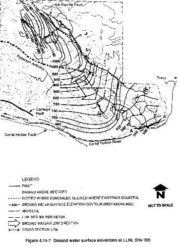
The Remedial Investigation identified trichloroethylene and perchloroethylene in the General Services Area ground water at concentrations exceeding federal or state drinking water standards. At least six plumes of volatile organic compounds have been identified in shallow alluvial and deeper bedrock aquifers in the General Services Area and offsite areas. In the western General Services Area, a trichloroethylene plume of relatively low concentrations has been identified. Several small, but more concentrated, shallow plumes of trichloroethylene have been identified; a separate, deeper trichloroethylene plume has also been detected in the Well 7 area. In the eastern General Services Area, a relatively dilute trichloroethylene plume originates near an onsite debris pile and extends offsite along Corral Hollow Creek. The downgradient extent of this eastern plume has not been identified due to the restrictions on drilling in close proximity to wetlands that contain certain species of special concern according to the State of California and Federal Candidate species (see Appendix F) including the red- legged frog and the California tiger salamander and their habitats.
Mass calculations show that total volume of volatile organic compounds in all six ground water plumes is about 0.2 gal, 70 percent of which exists in the eastern General Services Area and offsite plume. The total volume of contaminated ground water in the General Services Area is estimated at 37 million gal. Based on site information from the Remedial Investigation, general response actions were identified. General response actions are conceptual measures for a particular environmental medium that can be implemented to achieve remediation objectives.
The general purpose of remedial action is to prevent risks or impacts to public health and the environment. The specific remediation goals for the General Services Area are to:
- Prevent risks to human health and the environment associated with treatment, disposal, discharge, or reuse of released chemicals.
- Prevent migration of chemicals to the Neroly Formation water-supply aquifers, thereby protecting the quality of water in LLNL Site 300 and offsite supply wells.
- Remove chemicals from the subsurface, where required, in soil, soil vapor, bedrock, and ground water, thereby restoring the subsurface to the best condition practical.
The remediation objective of the recommended alternative (which includes ground water extraction in Corral Hollow, ground water treatment, and discharge of treated ground water) is to clean up contamination in ground water to concentrations below state and federal maximum contamination levels. LLNL proposes that the total volatile organic compounds concentration in ground water treatment facility discharge not exceed 5 ppb, and that no individual contaminants exceed the applicable maximum contamination level (Ferry et al., 1990).
A draft Feasibility Study was prepared for the General Services Area to comply with Regional Water Quality Control Board requirements (Ferry et al., 1990). Together with the previously conducted Remedial Investigation (McIlvride et al., 1990), which characterizes the site, the Feasibility Study forms the basis for evaluating and selecting methods for remediation of hazardous materials beneath the General Services Area and adjacent offsite areas.
LLNL will present design specifications for remedial actions in the Remedial Action Plan, following regulatory approval of the Site-Wide Remedial Investigation report currently being prepared and a new Feasibility Study report for the area (Ferry et al., 1990). A CERCLA Removal Action consisting of ground water extraction is currently in place and operating in the Eastern General Services Area. Another system is planned for the Central General Services Area. A separate Environmental Assessment was completed for these activities and is included in the Draft Feasibility Study.
The purpose of the remedial action at the General Services Area is to reduce potential risks and impacts to human health and the environment from the spread of volatile organic compounds and to restore subsurface conditions to the best practical condition. This remedial action has been separated into actions taken in the eastern and central portions of the General Services Area. The remedial action will include additional site investigation, ground water monitoring, and soil vapor extraction and treatment.
There are no risks to human health from released chemicals associated with site investigation, monitoring, and remediation because onsite monitoring will indicate acceptable working conditions during drilling, and the vapor produced during any treatment process would be captured and treated. The treatment system would be designed to meet regulatory requirements for all emissions. Impacts from ground water treatment of the contaminated ground water would improve ground water quality and mitigate existing and potential contamination.
The proposed preferred remedial action alternative in the western General Services Area is for additional subsurface investigation and ground water monitoring. The additional investigations will be performed to determine the full nature and extent of contamination at this area. It is anticipated that implementation of this alternative would not impact physiography, geology, seismicity, climate, cultural and historic resources, surface water, aesthetics, human health, noise, or traffic. During drilling operations insignificant temporary impacts would occur to ground water, air quality, soils, wildlife and vegetation, floodplains and wetlands and to the socioeconomics of the area.
The proposed preferred remedial action alternative at the central General Services Area is additional investigation, ground water and soil vapor extraction and treatment, and monitoring. The impacts associated with additional investigation and monitoring are the same as the impacts discussed for the western General Services Area above. Soil-vapor extraction and treatment would be conducted to achieve maximum capture of the contaminant plume at this site. Vacuum enhancement could be used to increase the yields of the ground water extraction wells. The impacts to the ground water conditions are anticipated to be beneficial. Extraction and treatment of the contaminated ground water would improve water quality and mitigate existing and potential contamination.
Effluent water from proposed ground water treatment systems at the General Services Area may be discharged into Corral Hollow Creek, an intermittent stream. Preliminary infiltration studies (Ferry et al., 1990) indicate that discharges from proposed ground water treatment systems would infiltrate rapidly into the coarse-grained streambed sediments within 100 ft of the discharge point and that no negative impacts to the downstream Corral Hollow Ecological Reserve would be experienced, nor would perennial flow be established. Water discharge from a ground water treatment facility would cause an expected 100-ft length of flow of surface water during the dry season. This flow would cause an increase of growth of existing riparian trees and shrubs and the establishment of additional vegetation. Habitat could be created for the California tiger salamander, foothill yellow-legged frog, and red-legged frog. Some vegetation would be expected to die following termination of the ground water extraction program.
Drilling- and construction-related disruption of the soil would occur during site investigation and remediation activities. This is expected to have minimal impact on the area, but if any areas were extensively disturbed, they would be revegetated with native grasses and/or shrubs to restore the area to its original condition. Minor disturbances of wildlife could occur from drilling and monitoring activities.
Ground water remediation in the General Services Area would have beneficial effects on land use and socioeconomics. The treatment operations would restore the ground water as a resource, thereby alleviating any restrictions on the range of feasible uses of the land. The remedial action would not require more than 10 additional workers. However, the number of workers at the site and the duration of their stay would not be constant or continuous. This increase in workers would not represent a substantial change, and represents the variability expected during normal operations.
Implementation of proposed remedial actions at LLNL Site 300 would have an overall beneficial impact on the ground water resources and land use limitations. The volume of ground water that would be removed from the bedrock aquifers is generally not expected to affect the capability of the aquifers to provide water for current or future development activities (Ferry et al., 1990) although careful monitoring of drawdowns, particularly during drought periods, will be required.
High Explosives Process Area
The High Explosives Process Area is a major facility located in the south-central portion of LLNL Site 300 (Figure 4.17-8). High explosive compounds are mixed, pressed, and machined for experimental purposes at various facilities within the process area. Rinsewater discharges from buildings within the High Explosives Process Area historically were disposed of by a combination of infiltration and evaporation in nine small unlined lagoons adjacent to processing Buildings 806/807, 807A, 807B, 817, 825, 826, 827 C/D, 827E, and 828. Initial investigations of these lagoons were conducted in 1982 (Raber, 1983) and use of these lagoons was terminated in 1985. Beginning in March 1986, LLNL conducted the hydrogeologic investigations required for permanent closure of the nine decommissioned lagoons. In October 1989, the lagoons were closed by covering them with impermeable clay caps.
In 1985, low concentrations of the high explosive compound RDX (maximum value of 350 mg/L) were detected in ground water near Building 815 in the High Explosives Process Area (Crow and Lamarre, 1990). Additional investigations have determined RDX to be present locally in two aquifers beneath Buildings 815 and 817.
Sixty-nine monitor wells (some constructed as early as 1984) and several soil borings were used to characterize the areal and vertical extent of contamination. Chemical constituents identified in the soil and ground water include RDX and HMX and trichloroethylene. Traces of fuel hydrocarbons and metals have also been found in the soil.
Concentration of high explosive compounds in the shallow perched and Neroly upper sandstone aquifers have remained essentially unchanged since 1986 and are consistent with historical trends. Trichloroethylene concentrations vary considerably over this period, but do not show any consistent increasing or decreasing trend. The trichloroethylene plume extends from Building 835 to the western General Services Area in the south.
To date, the EPA has not established a water-quality criterion for RDX and HMX, nor are they regulated under the Safe Drinking Water Act. In the absence of guidance for water quality goals, LLNL evaluated all known RDX and HMX toxicological data and reported a RDX drinking water criterion of 105 mg/L for the Site 300 ground water (Etnier, 1989). The evaluation of the HMX toxicological data could not be used to calculate a HMX drinking water criterion (Crow and Lamarre, 1990). However, HMX is considered to be much less toxic than RDX because of its lower solubility. Only trace to low concentrations of HMX have been detected in monitoring wells at the High Explosives Process Area, with a maximum reported concentration of 41 ppb (Crow and Lamarre, 1990).
The concentrations of RDX in perched aquifer ground water are somewhat higher than the 105 mg/L criterion. RDX levels in concentrations in the Neroly aquifer range from not detectable to 270 mg/L, or slightly above the suggested criterion. The average concentration of RDX in the ground water is less than the drinking water criterion.
The Draft Feasibility Study being prepared for this site will review available remedial technologies and associated costs for remediating trichloroethylene and high explosive compounds in ground water, soil, and rock. Three additional monitor wells were installed during the first quarter of 1991 as part of the ongoing trichloroethylene plume investigation. To locate the northern extent of the trichloroethylene plume, one well was installed west of Building 814. Monitor wells installed near Building 815 have assisted in defining the vertical extent of trichloroethylene and high explosive compounds in soil, rock, and ground water. One monitoring well was installed upgradient (north) of Building 827 to provide hydrostratigraphic information on the upper Neroly blue sandstone aquifer.
High explosive compounds beneath the closed rinsewater lagoons are present in low concentrations and confined to the unsaturated zone. Traces of volatile organic compounds are present beneath the 827C/D and 828 lagoons. At their present locations, these compounds pose no threat to human health, safety, or the environment. The force distributing these compounds in the unsaturated zone was the hydraulic head generated by rinsewater in the lagoons. With no further accumulation of liquids in the lagoons, the compounds should remain immobile.
To ensure this immobility, LLNL filled and capped the decommissioned lagoons with compacted backfill and clay soil. The compacted clay caps are a minimum of 2 ft thick and extend beyond the edges of the lagoons. The clay cap materials were selected, tested, and emplaced according to a closure plan approved by the California Regional Water Quality Control Board. To reduce the potential for degradation of the compacted clay cap by bioturbation, the caps were covered with 18 inches of uncompacted topsoil seeded with local grasses. The exception is the 825 Lagoon, which was covered instead with a concrete slab and holding tank for continued operations at Building 825. The lagoons at the High Explosives Process Area have been formally closed in accordance with a closure plan approved by the California Regional Water Quality Control Board.
Ongoing investigations of trichloroethylene and high explosive compounds in ground water will be reported in the new Feasibility Study and in the Site-Wide Remedial Investigation currently being prepared.
Landfill Pit 6
Landfill Pit 6 is in the southwestern portion of LLNL Site 300, approximately 200 ft from the southern boundary (Figure 4.17-8). Records show that Pit 6 received a variety of waste materials from the LLNL Livermore site and from the Lawrence Berkeley Laboratory. Following closure in 1973, Pit 6 was covered with locally obtained clay soil. The site has since been developed as a rifle range for use by the LLNL Protective Services Department, the California Highway Patrol, and other public safety officers.
Low concentrations of trichloroethylene and related volatile organic compounds were detected in ground water immediately downgradient of the landfill (Figure 4.17-9). The plume's configuration and results from an extensive soil gas survey suggest that low levels of trichloroethylene were released from the southeastern portion of the landfill. Ground water trichloroethylene concentrations generally are declining. The long axis of the plume is approximately parallel to the direction of ground water flow.
A draft Remedial Investigation report for the Pit 6 site (Taffet, 1990) was completed in December 1990, and a draft Feasibility Study of alternative remedial actions (Taffet et al., 1991) was completed March 31, 1991. The proposed remedial action alternative for Landfill Pit 6 includes modification of the landfill area and installation of a run-on/run-off diversion system to prevent water from infiltrating into the landfill. Monitoring and additional site investigation would also be performed. Other alternatives being considered include soil vapor and ground water extraction. Work planned for the Pit 6 area includes continued sampling of ground water monitor wells, monthly water-level measurement to further define local hydrogeology, and preparation of the Site-Wide Remedial Investigation report.
The risk to human health from potential long-term exposure to the volatile organic compound– contaminated ground water has been determined to be minimal (Taffet, 1990). Much of the trichloroethylene ground water plume is naturally volatilizing along a seepage face southeast of the landfill. Maximum concentrations in the plume are presently about 20 times the maximum concentration level for trichloroethylene (100 ppb), but concentrations are declining with time. The proposed remedial action alternative would not have an impact on ground water, air quality, soils, vegetation and wildlife, or noise and traffic.
Landfill Pit 8
Pit 8 is located several hundred feet northeast of Building 801 (Figure 4.17-8), within a narrow ravine. Low concentrations of trichloroethylene in ground water from two Pit 8 monitor wells are likely from release immediately upgradient (from the west) of the landfill and not from landfill contents. Other volatile organic compounds detected at Pit 8 included chloroform and Freon-113 at very low concentrations.
The extent of contamination in the immediate area of Pit 8 is unknown. The Pit 8 investigation is ongoing.
Landfill Closure Area
Debris from high explosives tests was disposed of in Landfill Pits 1 and 7 at the northern end of LLNL Site 300 (Figure 4.17-8). Landfill Pits 1 and 7 are unlined disposal units constructed prior to the establishment of liner requirements (Corey, 1988). Pit 1 was opened in 1961 and Pit 7 was opened in 1979. These pits were operated as single cells, and cover material was applied about four times a year (Corey, 1988). A mixture of low-level radioactive wastes and RCRA hazardous wastes generated from the firing of test assemblies was disposed of in Pits 1 and 7 (Corey, 1988).
In 1988 approximately 12,347 cu yd of gravel from all LLNL Site 300 firing tables were disposed of in landfill Pit 7. Also, the soils underlying firing table 851 were removed and placed in landfill Pit 7. The gravels were removed because activities of tritium and uranium exceeded background levels for some samples. Soils from firing table 851 were removed because beryllium and lead concentrations in one sample exceeded Soluble Threshold Limit Concentrations. Soils from other firing tables were not removed, because only a few of the samples contained either lead or beryllium at concentrations above the soluble threshold limit concentration or maximum concentration level. Furthermore, each soil sample was bounded by other samples above and below it with concentrations lower than the standards (Lamarre and Taffet, 1989).
Pits 1 and 7 were operated until November 8, 1988, under RCRA interim status. In March 1988, LLNL decided not to pursue its RCRA Part B permit for these landfills, and submitted a closure and postclosure plan to the regulatory agencies. In 1992 LLNL will complete closure of LLNL Site 300 Pits 1 and 7 as specified in the closure plan.
Monitor wells have been installed at all of the landfills, and periodic ground water analysis is conducted.
Freon-113 was also detected at Pit 1 but at levels far below the maximum contaminant level. Trichloroethylene, 1,1-dichloroethylene, and tritium concentrations in the Pit 7 Area wells did not change significantly between 1988 and 1989 (Lamarre, 1990). During the second quarter of 1989, slightly elevated levels of gross alpha activity were detected. This is likely from naturally occurring uranium in the ground water (Raber and Carpenter, 1983). In the fourth quarter of 1989, one monitor well exhibited a gross alpha activity slightly above the state maximum contaminant level of 15 pCi/L. Isotopic uranium analysis showed that this alpha activity was likely from naturally occurring uranium.
The landfills will be closed in accordance with guidelines prepared by the EPA, the California Regional Water Quality Control Board–Central Valley Region, and the California Department of Toxic Substances Control and in compliance with federal, state, and local regulations. Given the low mobility of waste contaminants in Pits 1 and 7 (lead, uranium, beryllium, and barium), their low concentrations, the high evapotranspiration rate at LLNL Site 300, and the absence of free liquids in the pits, the risk of constituent migration due to leaching is minimal (McIlvride et al., 1988).
Closed Pits 1 and 7 will receive postclosure monitoring in accordance with RCRA. Postclosure use of the areas at landfill Pits 1 and 7 will not disturb the final cover or any of the components of the monitoring system unless approved by the regulatory authorities.
Tritium Project
The Tritium Project Area (see Figure 4.17-9) includes the Pit 7 Complex, the Building 850/East Firing Area, and the Building 851 Area. Historically, debris from high explosive tests has been disposed of in landfills at the northern end of LLNL Site 300 (Lamarre, 1989). In 1981, a Hazardous Waste Assessment study of the hydrology, geology, and ground water chemistry associated with LLNL Site 300 landfills was initiated. As part of this project, monitor wells were installed at the landfills and a program of periodic ground water monitoring started.
In 1984, tritium levels in ground water samples from four of the wells were above the California drinking water standard of 20,000 pCi/L. An investigation delineated three distinct plumes of tritium in ground water, including the Pit 7 complex (which includes Pits 3 and 5), the Building 850 area in the West Firing Area, and near Pit 2 in the East Firing Area (Figure 4.17-8). In the Pit 7 complex area soil moisture above the water table was sampled for tritium. At the 1.3 ft to 2.5 ft interval, only one sample showed a tritium activity in excess of the drinking water standard (20,000 pCi/L) (Taffet et al., 1989). At approximately 15 ft above the current water table, the soil moisture tritium maxima occur. Tritium activities of 200,000 pCi/Lsm have been detected in this interval of the vadose zone. Tritium activities are an order of magnitude lower in the underlying ground water (Taffet and et al., 1989).
Tritium has been detected in the Neroly Formation, both in the shallow perched aquifer and in the regional aquifer immediately east of the southwestern branch of the Elk Ravine fault. Tritium plumes continue to migrate from 46 to 610 ft/year. The Pit 3 and Pit 5 plumes are migrating east-northeast. The Building 850 plume is migrating northeast and southeast. The only production well affected by tritium is well 1, located in the East Firing Area near the downgradient edge of the Building 850/Doall Ravine/East Firing Area plume. Well 1 is currently inactive and is used as a backup fire water supply well.
Tritium-contaminated ground water in the Pit 7 complex area is thought to originate from flooding by elevated water tables into Pits 3 and 5 during periods of high rainfall (Buddemeier et al., 1987c). Two separate tritium plumes originate from the Pit 7 complex area, one from Pit 3 and one from Pit 5 (Taffet et al., 1989). Contaminant fate and transport modeling predicts that because of tritium's radioactive decay, when the plumes reach the site boundary, they will contain tritium levels below the California drinking water standard (Buddemeier et al., 1987c).
The investigation of tritium in ground water at the Landfill Pit 7 complex was completed and a remedial investigation/feasibility study was submitted to EPA, the Regional Water Quality Control Board, RWQCB, and DHTS (Taffet, Oberdorfer, and McIlvride, 1989). The conclusion of the report stated that ground water is moving at a maximum of 15 meters per year towards the northern site boundary. Given that the radioactive decay half-life for tritium is 12.3 years, by the time this ground water reaches the site boundary along a most-direct flow path, tritium activities will be at or below background activities (200 pCi/L). Therefore, LLNL proposed the no action, continued monitoring alternative. No impact to human health or the environment is anticipated (see section 4.19).
The Remedial Investigation of the Building 850/East Firing Area identified tritium as the only contaminant released to ground water from the Building 850 firing table area. Tritium detected in ground water at a maximum present activity of 300,000 pCi/L exceeds the maximum contaminant level of 20,000 pCi/L. The tritium plume is migrating to the northeast down the Do-all Ravine in alluvium and weathered bedrock. A smaller portion of the tritium plume is migrating to the northeast from Building 850 in fractured bedrock (Buddemeier et al., 1987c). The plume, which averages 1000 to 1500 ft in width, has traveled almost 6000 ft from the Building 850 source (Taffet and Oberdorfer, 1991). Near Pit 2 in the East Firing Area, this plume enters the regional ground water flow system and migrates to the southeast. A Feasibility Study was prepared to address remedial action for compounds that may have been released in soil, rock, or ground water from the immediate vicinity of the Building 850 firing table at LLNL Site 300 (see Figure 4.17-8) (Taffet and Oberdorfer, 1991). The Feasibility Study, along with the previously conducted Remedial Investigation (Taffet et al., 1990) that characterizes the site, formed the basis for evaluating and selecting remediation methods to prevent further release of waste constituents from this area in the subsurface.
Ground water contaminant fate and transport modeling shows that when the Building 850 tritium plume reaches the nearest possible human exposure points (offsite water supply wells in Corral Hollow), it will contain tritium levels below the background activity in rainfall at the site and below the state MCL (Taffet and Oberdorfer, 1991). The preferred remedial action alternative includes combined technologies for the monitoring of ground water and tritium source isolation.
Source isolation can be achieved by the installation of a permanent plastic cover over the tritium source areas in the soil. This would reduce migration of tritium into the ground water from the vadose zone beneath the Building 850 Area. LLNL will present specific design specifications for remedial action in the Remedial Action Plan, following regulatory approval of the Feasibility Study and the Site-Wide Remedial Investigation Report and Baseline Risk Assessment that are currently underway.
Future work in the Tritium Project Area includes:
- Quarterly ground water sampling and analysis for tritium and periodic ground water level measurements.
A worst-case calculation of the dose received from using tritium-bearing ground water from the site boundary or the current exposure point was identified to be insignificant (Taffet and Oberdorfer, 1991). The general purpose of the remedial action that would be performed at this location is to prevent risks or impacts to public health and the environment. This would be achieved by preventing ground water containing more than 1000 pCi/L of tritium from reaching any receptor well, protecting drinking water supplies from potential contaminants released from the site, and preventing further release of tritium or any other compound from the Building 850 area.
It is possible that human exposure to tritium through the ground water pathway could occur if the contaminated aquifer were to be used as a drinking water source (Taffet and Oberdorfer, 1991). This would be unlikely because San Joaquin County does require a permit to be approved by the Department of Health Services and ascertains the location of any proposed wells. Well permits would likely be denied if the wells were near the contaminated ground water areas or might impact ground water remediation efforts. Additionally, LLNL Site 300 management does not plan to use the aquifer underlying the Building 850 area.
There would be no significant risk from utilizing the ground water at the site boundary (Taffet and Oberdorfer, 1991) as discussed above. Although no ground water treatment has been proposed as a component of the preferred alternative (see Taffet and Oberdorfer, 1991), treated water could be discharged to the atmosphere in the form of water vapor. Such action would require approval by regulatory agencies including EPA and San Joaquin County Air Pollution Control District. Tritium remediation and associated potential impacts will be addressed in the Site-Wide Remedial Investigation Report and the Site-Wide Baseline Public Health Risk Assessment.
Building 865
Building 865 was the test facility for the Advanced Test Accelerator experimental project (Figure 4.17-9). From 1982 to 1989, the Advanced Test Accelerator used a linear electron accelerator for charged particle-beam research (Cabayan and Eccles, 1986). The facility consisted of a control and support building, a power supply building, diagnostic equipment, two modular office buildings, a tunnel building that contained the pulse-forming unit, an electron injector, and a series of accelerator modules (Energy and Technology Review Reprints, 1984). The facility did not use radioactive or high explosive materials (UC, 1986).
Floor washdown water drained from Building 865 to three aboveground tanks located southwest of the building. This water contained insulating oil and Freon-113. Insulating oil was used for transferring heat in the electrical transmission lines and the accelerator modules. Freon-113 was used as a solvent for cleaning the accelerator modules and other experiment apparatus. Before installation of the aboveground tanks in late 1985, rinsewater was stored in a lined 7000-gal surface impoundment and an underground tank. When the tanks or impoundment were filled, the rinsewater was transferred to tanker trucks for disposal offsite.
As part of a routine upgrade project for the Building 865 rinsewater retention system, 16 soil and bedrock samples were collected at the site of three aboveground tanks. Oil and grease were found in both the soil and bedrock samples and even in a presumed background sample. Some soil and bedrock samples were also analyzed for purgeable aromatics and volatile organic compounds. No detectable concentrations have been reported for these analytes.
It is believed that the lined surface impoundment leaked or that rinsewater was spilled during transferring operations. Preliminary findings support this conclusion, and additional site characterization will be conducted (Lamarre, 1990).
Table 4.17-11 Summary of Potential and Detected Soil Contaminants at LLNL Site 300
| Area | Potential Soil Contaminanta | Soil Contaminants Reported at Concentrations Above Detection Limitb | |||||
| VOC | FHC | Metals | PCB | Rad | HE | ||
| Environmental Test Area (Building 834 Complex) | Y | N | N | N | N | N | VOC: TCE |
| General Services Area | Y | N | N | N | N | N | VOC: PCE, TCE, 1,2-DCE |
| High Explosives Process Area | Y | N | N | N | N | Y | VOC: TCE
HE: RDX, HMX |
| Landfill Pit 6 | Y | N | Y | Y | N | N | TCE (soil vapor survey) |
| Landfill Pit 8 | Y | N | Y | N | Y | N | None identified |
| Landfill Closure Area:
Landfill Pit 1 |
Y | N | Y | N | Y | N | None identified |
| Landfill Pit 7 | N | N | Y | N | Y | N | Rad: tritium |
| Tritium Project | Y | N | N | N | Y | N | Rad: tritium |
| UST location near Building 850 | N | Y | N | N | Y | N | FHC: diesel
Rad: tritium |
| UST location at Building 874 (874-11D) | N | Y | N | N | N | N | FHC: diesel |
| Building 865 with associated tanks | Y | Y | N | N | N | N | FHC: oil and grease |
Y = Potential soil contaminant
N = Not a potential soil contaminant
VOC
= Volatile organic compound
FHC= Fuel hydrocarbon constituent
UST=
Underground storage tank
PCB = Polychlorinated biphenyl
Rad =
Radiological constituent
HE = High explosives (includes RDX, HMX)
TCE
= Trichloroethylene
RDX = Cyclo-1, 3, 5 – trimethylene -2, 4, 6 – trinitramine
HMX
= cyclotetramethylenetetranitramine
1,2-DCE = 1,2-Dichloroethene
PCE = Perchloroethylene
a Based upon known or suspected
contaminant releases or hazardous materials use, storage, or disposal practices
strongly suggestive of (a) potential release(s).
b For ranges of concentrations for
key contaminants and tritium activities detected at each area investigated, see
Table 4.17-11.
Table 4.17-12 Summary of Soil Concentrations for Potential Source Investigations at LLNL Site 300
| Area Investigated | Rangea of Total VOCs (ppb) | Range of Total Aromatic Hydrocarbons (ppb) | Range of Total PCBs (ppb) | Range of HE compounds (ppb) | Range of Tritium Activities (pCi/LSM)b | Metals |
| Environmental Test Area 834 Complex (1) | Trace–High | Trace | N/Ac | Very Low | <200d–440 | <STLCe |
| General Services Area (2) | Trace–Very Low | Trace–Very Low | N/A | N/Df | N/A | <STLC |
| High Explosives Process Area (3) | Trace–Low | Trace–Moderate | N/A | Trace–High | N/A | >STLC |
| Landfill Pit 6 (4) | Trace–Low | N/A | N/D | N/A | N/A | N/A |
| Landfill Pit 8 (5) | Trace | Trace | N/A | N/A | N/A | <STLC |
| Landfill Closure Area (6) Landfill Pit 1 Landfill Pit 7 |
N/D N/D |
N/D N/D |
N/A N/D |
N/D N/A |
N/D N/D |
N/D N/D |
| Tritium Project (7) | N/A | N/A | N/A | N/A | <192–11,000,000 | >STLC |
| USTg near Building 850 (8) | N/D | N/D | N/A | N/A | 9,600–71,900 | <STLC |
| UST at Building 874 (874-11D) (9) | N/D | N/D | N/A | N/A | N/A | N/A |
| Building 865 with associated tanks (10) | N/D | N/D | N/A | N/A | N/A | N/A |
aTrace = <5 ppb.
Very Low= 5–49
ppb.
Low = 50–449 ppb.
Moderate= 500—5000 ppb.
High = >5000
ppb.
Note: Concentration ranges and qualifiers (e.g. low, medium, high, etc.) not based on regulatory action levels. See text for discussion of those areas which have been determined, based on site specific risk assessment criteria, to require remediation.
b pCi/LSM = picocuries per liter soil
moisture.
c N/A = None analyzed.
d <200 = less than detection limit.
e STLC = Soluble threshold limit concentration.
f N/D = None detected.
gUST = Underground storage tank.
Source: (1) Bryn et al., 1990; Webster-Scholten et al., 1991; (2) McIlvride et al. 1990; (3) Crow and Lamarre, 1990; Webster-Scholten and Crow, 1989; (4) Taffet, 1990; Taffet and Lamarre, 1986; CH2M Hill, 1985; Raber and Carpenter, 1983; (5) Taffet, 1989; (6) Taffet et al., 1989; Buddemeier et al., 1987c; Raber and Carpenter, 1983; Carlsen et al., 1987; (7) Taffet et al., 1990; Taffet and Oberdorfer, 1991; (8) Carlsen, 1991; (9) Copland and Lamarre, 1990; (10) Lamarre, 1990.
Table 4.17-13 Key Area Investigation References for LLNL Site 300
| Area | Key References |
| Environmental Test Area | Ruggieri et al. 1987 Carpenter et al., 1983, 1986 Buddemeier et al., 1987a, 1987c Lamarre, 1989, 1990 Bryn et al., 1990 |
| General Services Area | Buddemeier et al., 1987b Weiss Associates, 1987 Lamarre, 1989, 1990 Crow and Lamarre, 1990 McIlvride et al., 1990 |
| High Explosives Process Area | Raber, 1983 Ruggieri et al., 1987 Buddemeier et al., 1987b Brown and Caldwell, Inc., 1987a, 1987b Carpenter et al., 1988 Webster-Scholten and Crow, 1989 Crow et al., 1986 |
| Landfill Pit 6 | Raber and Carpenter, 1983 CH2M Hill, 1985 Brown and Caldwell, 1987a Taffet et al., 1990 Taffet and Lamarre, 1986 |
| Landfill Pit 8 | LLNL, 1989a Taffet, 1989 |
| Landfill Closures | Buddemeier et al., 1987a, 1987b Carlsen et al., 1987 Raber and Carpenter, 1983 LLNL, 1990d |
| Tritium Project |
Lamarre, 1989 Buddemeier et al., 1985, 1987a, 1987b, 1987c LLNL, 1989a, 1990d Taffet et al., 1990 |
| Underground Tanks | LLNL, 1989a Carlsen, 1991 |
| Building 865 | Cabayan and Eccles, 1986 Energy and Technology Review Reprints, 1984 Copland and Lamarre, 1990 |
| Enhanced Soil Bioremediation Pilot | Lamarre, 1990 |
| Well Sealing | Lamarre, 1989 |
Table 4.17-14 Summary of Potential and Detected Ground Water Contaminants at LLNL Site 300
| Area | Potential Water Contaminant* | Water Contaminants Detected at Concentrations Above Maximum Concentration Level | |||||
| VOC | FHC | Metals | PCB | Rad | HE | ||
| Environmental Test Area (Building 834 Complex) | Y | N | N | N | N | N | VOC: TCE |
| General Services Area | Y | Y | N | N | N | N | VOC: PCE, TCE, 1,2-DCE |
| High Explosives Process Area | Y | N | N | N | N | Y | VOC: TCE HE: HMX RDX OTHER: T |
| Landfill Pit 6 | Y | N | N | N | N | N | VOC: TCE |
| Landfill Pit 8 | Y | N | N | N | N | N | VOC: TCE, 1,2-DCA |
| Landfill Closure Area: Landfill Pit 1 |
N | N | N | N | N | N | |
| Landfill Pit 7 | Y | N | N | N | Y | Y | VOC: TCE, 1,1-DCE
HE: HMX RDX Rad: tritium |
| Tritium Project | Y | N | N | N | Y | N | Rad: tritium |
| UST near Building 850 | N | Y | N | N | N | N | None identified |
| UST at Building 874 (874-11D) | N | Y | N | N | N | N | None identified |
| Building 865 with associated tanks | Y | Y | Y | N | N | N | None identified |
| Y = Potential water contaminant N = Not a potential water contaminant VOC = Volatile organic compound FHC = Fuel hydrocarbon constituent PCB = Polychlorinated biphenyl Rad = Radiological constituent HE = High explosives |
TCE = Trichloroethylene
1,1-DCE= 1,1-Dichloroethene 1,2-DCA= 1,2-Dichloroethane 1,2-DCE= 1,2-Dichloroethene PCE = Perchloroethylene T = Toluene RDX = Cyclo-1, 3, 5 – trimethylene -2, 4, 6 – trinitrimine HMX = Cyclotetramethylenetetranitramine |
* Based upon known or suspected contaminant releases or hazardous materials use, storage, or disposal practices strongly suggestive of a potential release.
4.17.4 Site Contamination-SNL, Livermore
4.17.4.1 SNL, Livermore Historic Use of Hazardous Materials
From 1942 until 1947, the U.S. Navy disposed of trash and construction debris at the southern end of the Navy property, the location of the present SNL, Livermore Navy Landfill. The site consists of debris fill placed in and around a natural ravine that extends approximately 200 ft by 400 ft. No historical records are available regarding the nature and quantity of materials disposed of in the Navy Landfill.
LLNL began operations in 1952 and disposed of construction debris and empty containers in the landfill until 1960 (Rowe, 1960). Wastes were trucked to the ravine and deposited over the sides. Some fill material was dumped on top of the waste to provide a firm surface for roads. Debris was visible in historic site photographs; materials included large pieces of concrete, machine turnings, wire, glass, and plastic. Visible debris is now greatly reduced at the site. No mixed or radioactive wastes are known to be present; however, low concentrations of acetone, dichloromethylene, trichloracetic acid, Freon-113, and copper and lead were found at the site (DOE, 1990f). SNL, Livermore took over this land in 1956 but never used the Navy Landfill site for disposal of any materials. Lithium, potassium, and sodium scrap metal were treated at a high explosives burn pit located east of the Navy Landfill incinerator.
Diesel oil used as heating oil for buildings and the nonhazardous waste incinerator has been stored in a 179,900-gal tank since 1972. Small quantities of waste solvents or gasoline were utilized in a fire extinguisher training area near Building 961 between 1959 and 1978.
The Trudell Auto Repair Shop, formerly a gasoline station/repair shop, was built in the early 1950s (DOE, 1986c). Fuels, oils, solvents, waste oils and solvents, and other materials associated with automotive repair and maintenance were used and stored at this site. This site was acquired by DOE in 1987 as part of its security enhancement program.
4.17.4.2 Contamination Sites, Remediation Efforts, and Potential Impacts of Remediation
The following sections describe site facilities, including for each the site history, previous site investigations, nature and extent of soil and ground water contamination, the existing situation, and planned activities at the site. Figure 4.17-10 and Figure 4.17-11 show the locations of areas with potential soil and ground water contamination at SNL, Livermore. The sites and their potential contaminants are inventoried in Table 4.17-15. Reported soil contaminant concentrations are summarized in Table 4.17-16. There have been three contaminated sites which have been investigated at SNL, Livermore (Navy Landfill, Fuel Oil Spill, Trudell Auto Repair Shop); also six sites have been classified as Miscellaneous Sites. Other sites will not undergo further investigation because they have been remediated or are in the process of remediation under different environmental programs (Table 4.17-17). More in-depth information pertaining to these site-specific areas of investigation can be obtained from references listed in Table 4.17-18. Tables 4.17-15, 4.17-16, and 4.17-19 summarize potential contaminants and contaminants identified in soils and ground water at each of the SNL, Livermore sites.
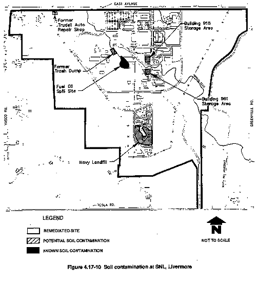
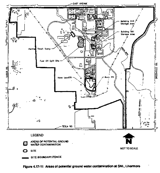
Navy Landfill
Thirteen soil boreholes sampled before 1989 showed very low concentrations of acetone, dichloromethylene, trichloroacetic acid, Freon-113, copper, and lead in soil. Both lead and copper concentrations exceeded soluble threshold limit concentrations (Ahlquist et al., 1985). No constituents were found in ground water that exceeded California regulatory drinking water standards, although Freon-113 was found in very low concentrations (Ahlquist et al., 1985). Freon is a common laboratory reagent and often a source of laboratory contamination.
A Solid Waste Water Quality Assessment Test field program was performed at the Navy Landfill in 1989 (DOE, 1990f). Three new monitor wells were installed, soil samples were collected from two lysimeter boreholes, one piezometer was installed north of the Las Positas fault, one soil borehole was drilled onsite, and four test pits were dug by backhoe (DOE, 1990f).
As a result of the Navy Landfill investigation no pesticides, polychlorinated biphenyls, or explosives were detected in any soil sample collected at the Navy Landfill site during the 1989 remedial investigation (DOE, 1990f). However, low concentrations of combined oil and grease were identified in three soil samples from the onsite lysimeter and in two samples from the onsite borehole. Because the oil and grease analysis is nonspecific, it may reflect naturally occurring organic compounds in the soil, including humic acids. None of the metals detected in soil samples approached the total threshold limit concentration of the California Assessment Manual (California Regional Water Quality Control Board, 1986), and all were generally within the typical concentration ranges in natural soils in the western United States.
No contamination of vadose zone soil-pore water was found. No pesticides, polychlorinated biphenyls, or explosives were identified in any water sample collected from the Navy Landfill site (DOE, 1990c). Total organic carbon and total organic halogens were detected in several samples at low concentrations during the first quarter sampling, but were not identified in subsequent quarterly samplings. This indicates possible cross-contamination from equipment in the first quarter samples. Total organic carbon and total organic halogens are, therefore, not considered to be contaminants at the Navy Landfill site.
There does not appear to be contamination of the soil or ground water at the Navy Landfill site, and no contaminants have been found in the area ground water. SNL, Livermore has, therefore, requested release from further remedial action at this site from the Regional Water Quality Control Board. Regulatory acceptance of the Solid Waste Water Quality Assessment Test Report and approval of the SNL, Livermore request to release this site from further investigation is pending. A response to SNL, Livermore's request is expected in the first quarter of Fiscal Year 1992 from the Regional Water Quality Control Board. SNL, Livermore plans to regrade and landscape the surface of the Navy Landfill to provide a safe working environment, prevent erosion, and prevent slope failure of the site.
Fuel Oil Spill
In February 1975, 59,500 gal of No. 2 diesel fuel oil spilled when a transfer line buried 4 ft underground was accidently punctured (DOE, 1986c). The spill occurred 75 ft north of the aboveground fuel storage tank. Some of the diesel fuel infiltrated the soil underlying the spill site, and the remainder migrated laterally in a light-pole trench adjacent to the spill and then migrated vertically beneath the trench into the underlying soil.
Since 1984, SNL, Livermore, its subcontractors, and LLNL have drilled and sampled 37 boreholes and 16 monitor wells at the Fuel Oil Spill site (Figure 4.17-11). Soil samples were analyzed for chemical contaminants and geotechnical parameters. Ground water samples were analyzed for chemical contaminants. Ground water levels were evaluated for flow system characteristics of the upper aquifer. The data were used to develop a conceptual site model of contaminant migration and provide lateral extent and depth profiles for contaminants at the Fuel Oil Spill site.
The interval of highest total petroleum hydrocarbon soil contamination is from 10 to 30 ft below ground surface. The highest total petroleum hydrocarbon concentrations (1000–10,000 ppm) are limited to the area closest to the source. The greatest areal extent of soil contamination is at the 100 ft depth. At this depth, the total fuel hydrocarbon concentrations ranging from 1000 to 10,000 ppm extend to approximately 120 ft downgradient to the northwest and approximately 100 ft cross-gradient to the southwest of the spill release point. No contamination was detected below 101 ft during the 1988 Fuel Oil Spill site investigation (DOE, 1990b). The total volume of soil contaminated with total fuel hydrocarbons was estimated to be 45,400 cu yd (DOE, 1990b).
Benzene, toluene, ethylbenzene, and xylene were found in the soil. Contaminants appear to be within the more permeable gravel-sand-silt units beneath the Fuel Oil Spill site with the highest contaminant concentrations near the end of the light-pole trench and not closest to the spill point. Analysis for metals showed background metal concentrations in the soil. Four of the boreholes showed no soil contamination at all.
Benzene contamination was found at concentrations of up to 3 ppb in ground water samples in three wells until May 1986. In all subsequent ground water sampling investigations at the fuel oil spill site since May 1986, benzene has not been detected in any well. No other fuel hydrocarbons have been detected in any ground water sampling investigation. Two of the wells where benzene was detected in ground water samples have since gone dry. No volatile organic compounds (as differentiated from fuel hydrocarbons, as shown in Table 4.17-19) were detected in any of the ground water samples from the wells. Bis(2-ethylhexyl)phthalate was detected in one downgradient well, but this compound is a common laboratory contaminant and a component of polyvinyl chloride, not of diesel fuel. Ground water analyses show that manganese concentrations in three downgradient wells and iron concentrations in one downgradient well were above secondary drinking water standards and above background concentrations.
A qualitative risk assessment evaluated the potential threat to human health and the environment from the Fuel Oil Spill site. Air and surface water exposure pathways were considered insignificant. The only important exposure pathway would be from ingestion of ground water from a hypothetical well drilled into the uppermost aquifer at the Fuel Oil Spill Site. Only the active treatment or disposal options and alternatives provided would guarantee protection of human health and the environment. However, if the contamination does not migrate significantly, or ground water does not continue to rise, other treatments or no action provide equal protection. An in situ pilot study system is being designed to evaluate the feasibility of bioremediation at this location as one of the active treatment options.
The pilot study would determine whether bioremediation at the Fuel Oil Spill site is appropriate and would provide information for treatment facilities design. The Regional Water Quality Control Board has agreed with SNL, Livermore to proceed with a pilot study that would assess the effectiveness of in situ bioremediation. A Remedial Action Plan that would identify the implementation of this pilot study is planned to be submitted to the Regional Water Quality Control Board in the first quarter of 1992. The SNL, Livermore is planning to implement the pilot study in the fourth quarter of 1992.
Trudell Auto Repair Shop
The Trudell Auto Repair Shop site (Figure 4.17-10) was formerly occupied by a gasoline service station in the 1950s (DOE, 1986c). The service station dispensed gasoline and performed minor auto repair work. Although the gas pumps were removed in 1965 and the facility was operated as an auto repair shop, the underground gasoline tanks remained in place. During the fuel shortage of the early 1970s, the underground tanks were used by the repair shop for temporary fuel storage. SNL, Livermore purchased the property in 1987 as a security buffer zone between the surrounding properties and the site. Five areas were identified as potential sources: the septic tank leach field, the south waste oil area, the east waste oil area, the underground storage tank area, and nonpoint sources.
Two remedial investigations were conducted at the Trudell Auto Repair Shop site. The first included soil gas sampling, ground-penetrating radar, and surface soil sampling. The data showed no sources of volatile organic compounds. However, low concentrations of volatile organic compounds were detected in soils to a depth of 72.5 ft during the installation of a ground water monitor well at the Trudell property as part of the LLNL ground water investigation program. Volatile organic compounds were also detected in saturated soil samples collected from this monitor well from the first through fifth waterbearing zones. However, these concentrations may have reflected cross-contamination from installation of the monitor well. Therefore, the Regional Water Quality Control Board requested borehole sampling to verify the findings.
In the second remedial investigation a total of 36 grab soil samples and 5 surface soil samples were collected in the septic system leach field area. A total of 12 boreholes were also drilled as part of the second remedial investigation; four 20-ft boreholes in the southern waste oil area, four 30-ft boreholes in the east waste oil area, one 20-ft borehole near the underground storage tank, and three 30-ft boreholes at non–point source locations. Although elevated concentrations of various organic compounds and metals were detected at many of these locations (see Tables 4.17-15 and 4.17-16), the contaminants were generally limited to the upper 5 ft.
The Trudell Auto Repair Shop site remediation objective was to ensure that human health and the environment were protected. An interim remedial measure by excavation was implemented in June 1990. Soil contamination consisting of fuel hydrocarbon compounds (benzene, toluene, ethylbenzene, and xylene) and metals (see Table 4.17-15 and Table 4.17-16) was remediated through removal of soils to a maximum depth of 8 ft and offsite disposal. All contaminated soil was removed to a licensed disposal facility. In addition, a previously unidentified hydrocarbon underground storage tank was also removed. Sampling during the excavation verified that the source areas were removed.
The Trudell Auto Repair Shop site is within the boundaries of an existing contaminant plume in the alluvial aquifer system (DOE, 1990f). The results of the interim remedial action removed all contaminated soils at this site. Soil contamination was not present below a depth of 20 ft at this site, and ground water is at a depth of approximately 80 ft. Therefore, ground water contamination below and in the vicinity of the site cannot be attributed to the sources of soil contamination at the Trudell Auto Repair Shop site. Closure was approved by the California Regional Water Quality Control Board on November 16, 1990.
On November 16, 1990, the Regional Water Quality Control Board completed its review of the Trudell Auto Repair Shop Feasibility Study Report (DOE, 1990f) and status reports documenting the cleanup, and issued a finding that the reports addressed the Board's concerns. Accordingly, the Board noted that provisions C.2.a and C.2.b of the SNL, Livermore cleanup order 89-184 were satisfied. Further activities, therefore, are unnecessary at the Trudell Auto Repair Shop site.
Miscellaneous Sites
A preliminary assessment/site inspection was performed by DOE at SNL, Livermore in 1986. The results of this inspection concluded that, because of the nature of previous activities performed, no site posed an immediate threat to human health and the environment. However, various sites had a potential for low levels of soil contamination because of the historical activities performed at these locations (DOE, 1991b). These sites are identified as the SNL, Livermore Miscellaneous Sites, including Arroyo Seco, a former trash dump area, a fire extinguisher training area, two waste material storage areas, and a high explosives burn pit. These sites were also investigated during DOE Environmental Survey Audit with associated sampling that was performed at SNL, Livermore in 1988 (DOE, 1991b). The data collected during the Environmental Study Audit supported the conclusions of the preliminary assessment/site inspection (DOE, 1989d). However, upon review of the data that were reported in the Survey Data Report, analytical values were found to be questionable and could not be used to verify that a site did or did not contain contaminated soils. Therefore, a second soil sampling program was performed in 1991 (DOE, 1991b).
SNL, Livermore was required by the Regional Water Quality Control Board to identify the location of all potential sources of hazardous materials disposed, or discharged, at its facility and to determine if a discharge to soil or ground water had occurred. Although no compliance deadline was identified, SNL, Livermore performed a Reconnaissance Investigation in June 1991. Investigation findings concluded that no organic or inorganic contaminants above RCRA action levels were present. Tests also indicated no leaching potential for gasoline and diesel. No organic or inorganic constituents appear to be migrating from any of the miscellaneous sites (DOE, 1991b). The results of this investigation were submitted to the Regional Water Quality Control Board in the fourth quarter of 1991. The acceptance of closure of these sites by the Regional Water Quality Control Board is pending, and no further action at these locations by SNL, Livermore is expected.
Information available for each of the SNL, Livermore miscellaneous sites is summarized below.
Arroyo Seco
Storm water from SNL, Livermore is periodically discharged as runoff into Arroyo Seco. Soil samples were collected in the arroyo during DOE Environmental Survey Audit (DOE, 1989d).
DOE Environmental Survey Audit (DOE, 1989d) identified Arroyo Seco as the receptor of non-point source water discharged as runoff from SNL, Livermore. There was no indication of contamination in arroyo sediments collected during this survey (DOE, 1989c). However, because of uncertainties in the data, additional sampling was recommended to verify the absence of contamination (DOE, 1991b).
The Arroyo Seco Area is an active ephemeral drainage. Only drainage from the storm water sewer discharges currently enter the Arroyo Seco drainage. New sources are not expected, although undocumented historical releases may contribute to any contamination.
The maximum concentrations of organic constituents of di-n-butyl phthalate (0.7 mg/kg), phenol (26.0 mg/kg), and beta BHG (0.038 mg/kg) were below proposed Resource Conservation and Recovery Act (RCRA) action levels of 8000, 50,000, and 4 mg/kg, respectively (40 C.F.R. 264). The maximum levels of total petroleum hydrocarbons (11 mg/kg) and toluene (0.006 mg/kg) were below the State of California maximum allowable levels of 100 and 20,000 mg/kg, respectively, using Table 2-1, Leaching Potential Analysis for Gasoline and Diesel, from the Leaking Underground Fuel Tank Manual (SWRCB, 1989). Organic and inorganic constituents identified in Arroyo Seco are not contaminants of concern.
Sediments in Arroyo Seco were also analyzed for selected radionuclides, gross alpha, and gross beta. Cesium-137, potassium-40, gross alpha, and gross beta concentrations detected in Arroyo Seco sediments were considered to be naturally occurring background concentrations. Further downstream, the tritium concentrations drop, and there is no significant difference between upstream and downstream concentrations of tritium. Concentrations of tritium in Arroyo Seco sediments were low, and soil-pore water is not considered to be a drinking water source; therefore, tritium does not pose a risk to human health or the environment, and radionuclides are not considered to be contaminants of concern at the SNL, Livermore Arroyo Seco site.
Former Trash Dump Adjacent to Arroyo Seco
Near-surface samples were collected at 15 locations at Arroyo Seco. Near-surface samples were collected from approximately 1-ft to 3-ft depths.
Previous owners of the SNL, Livermore property used a portion of Arroyo Seco as a trash dump. The trash was removed to the Livermore city dump (DOE, 1986c), and in 1970 Arroyo Seco was rechanneled. Soil and concrete were dumped into the former trash dump to prevent erosion. Records show that no hazardous constituents were present in the trash in this fill material. Sampling was not performed at this location, although it was recommended to verify the absence of contaminated soils (DOE, 1991b).
Several extractable organic compounds and volatile organic compounds were detected at very low concentrations during DOE Environmental Survey Audit (DOE, 1989d). Radiochemical and metals analyses were performed, but contamination was not detected. In 1991, near-surface and subsurface soil samples were collected at three borehole locations near the Former Trash Dump. No organic and inorganic constituents of concern were identified in the Former Trash Dump Area.
Fire Extinguisher Training Area
The Fire Extinguisher Training Area was located east of Building 961. During training exercises, waste solvents or gasoline were poured on the ground, ignited, and then extinguished by trainees. Approximately 10 training sessions were held each year from 1959 to 1978.
DOE Environmental Survey Audit (DOE, 1989d) identified the Fire Extinguisher Training Area as potentially contaminated, but data for this location shows no contaminated soils (DOE, 1989d). Concentrations of metals in samples from the fire extinguisher training area were below regulatory limits (DOE, 1989d). Several extractable organic compounds and volatile organic compounds were detected at concentrations below the contract-required detection limit. Radiochemistry identified gross alpha, gross beta, potassium-40, and cesium-137 in concentrations similar to those in Arroyo Seco.
Based upon the uncertainty in the Environmental Survey Audit data, additional sampling was performed. Nine near-surface samples and two boreholes were completed in the Old Fire Extinguisher Training Area. No contaminants of concern were identified at the SNL Old Fire Extinguisher Training Area site (DOE, 1991b).
Building 918 and Building 961 Storage Areas
Both the decontamination and waste storage area associated with Building 961 and a storage area surrounding Building 918 (Figure 4.17-10) were identified as requiring investigation during the preliminary site inspection (DOE, 1986c). Raw stocks of metals, oils, solvents, acids, and compressed gases were stored in the surrounding area. There are no sumps or drains leading into the sewer line from this building. Waste oil drums were stored on the west side of Building 918, and occasionally, when rainwater collected in them, these drums overflowed. SNL, Livermore has installed berms at the Building 918 and 961 areas to prevent spills from migrating into Arroyo Seco. Open drums are no longer stored onsite.
No surface or subsurface samples had been collected at these locations, and no additional information was known about the possible presence of contaminants. DOE, therefore, recommended surface and subsurface soil sampling (DOE, 1991b). The Building 918 and Building 961 storage areas are active storage areas, and currently comply with all applicable state and federal regulations for storage of hazardous materials.
Five near-surface samples and two boreholes were completed at the Building 918 storage area. Laboratory analyses did not detect elevated concentrations of organic compounds in the borehole samples. Metals were not detected above the background concentrations found at SNL, Livermore in any of the near-surface soil samples. Therefore, organic and inorganic constituents in the SNL Building 918 storage area are not considered to be contaminants of concern.
Five near-surface samples and two boreholes were completed in the Building 961 storage area. Metals were not detected above the background concentrations found at SNL, Livermore in any of the near-surface soil or borehole samples. There were no organic or inorganic contaminants of concern were detected at the SNL, Livermore Building 961 storage area site.
Navy Landfill Burn Pit
A high explosives burn pit (approximately 30 by 30 ft and about 10 to 20 ft deep) was located east of the Navy Landfill incinerator (DOE, 1991b). Lithium, potassium, and sodium scrap were treated here by burning or spraying with water. The reactive nature of the metals treated in the pit is not known (DOE, 1991b). The burn pit became inactive in the 1950s and has since been filled and paved over.
No surface or subsurface samples had been collected at these locations, and no additional information was known regarding the possible presence of contaminants. DOE, therefore, recommended surface and subsurface soil sampling (DOE, 1991b).
Metals were found in concentrations slightly higher than background levels during DOE Environmental Survey Audit (DOE, 1986c). Extractable and volatile organic compounds were identified, but were below the contract-required detection limit. Radiochemistry identified gross alpha, gross beta, potassium-40, and cesium-137 in concentrations similar to those found in Arroyo Seco. However, based upon the uncertainty in the Environmental Survey Audit data, additional sampling was performed.
One borehole was sampled in the Former Burn Pit. No organic contaminants were detected in analytical laboratory assays of borehole samples. Low levels of nickel, cobalt, and barium above the background concentrations for metals at SNL, Livermore were detected in borehole samples. However, the concentrations of these constituents were below background concentration ranges found in natural soils in the western United States and below the proposed RCRA action levels for nickel and barium in soil. No proposed RCRA action level exists for cobalt in soil. Cobalt is not considered to be a threat to human health and the environment at SNL. The burn pit is also covered by asphalt, and there would be no migration. Therefore, there were no organic or inorganic contaminants of concern detected at the SNL, Livermore former burn pit site (DOE, 1991b).
Table 4.17-15 Summary of Potential and Detected Soil Contaminantsa at SNL, Livermore
| Area | Potential Soil Contaminant | Soil Contaminants Detected at Concentrations Above Detection Limit | ||||||
| VOC | FHC | Metals | PCB | Rad | HE | Other | ||
| Navy Landfill Area | Y | N | Y | N | N | Y | 1,2 | None identified |
| Fuel Oil Spill Area | N | Y | N | N | N | N | FHC: B, T, X, E, diesel | |
| Trudell Auto Repair Shop (remediated) | Y | Y | Y | N | N | N | 2 | VOC: PCE, TCE, methylene chloride,
acetone
FHC: B, T, X, E, fluoranthene, heavy and light hydrocarbons, 2-methylnaphthalene, naphthalene, oil and grease, bis(2-ethylhexyl)phthalate,* di-n-octylphthalate Metals: As, Cd, Cr, Pb, Zn, Ba, Co, Cu, Ni, Ag, Ti Other: Assorted pesticides, 2-butanone |
| Arroyo Seco | Y | Y | N | Y | Y | N | 2 | None identified |
| Former Trash Dump Area | N | N | N | N | N | N | None identified | |
| Fire Extinguisher Training Area | N | Y | N | N | N | N | None identified | |
| Building 918/961 Decon Storage Area | N | Y | Y | Y | N | N | None identified | |
| Burn Pit at Navy Landfill | N | N | Y | N | N | Y | Metals: Pb, Ni, Zn | |
| Building 962 Storage Area | N | N | N | N | N | N | 2 | None identified |
* = Possible laboratory contaminant
FHC = Fuel Hydrocarbon Compound
TCE= Trichloroethylene
Co= Cobalt
1 = Trichloroacetic acid, acetone
HE = High explosives (includes
RDX, HMX)
As = Arsenic
Cu = Copper
2 = Pesticides
B = Benzene
Cd = Cadmium
Ni = Nickel Y =
Potential soil contaminant
T = Toluene
Cr = Chromium
Ag =
Silver
N = Not a potential soil contaminant
X = Xylene
Pb = Lead
Ti
= Titanium
VOC = Volatile organic compound
E = Ethylbenzene
Zn = Zinc
Rad = Radiological constituent
PCE = Perchloroethylene
Ba =
Barium
a Based upon known or suspected
contaminant releases or hazardous materials use, storage, or disposal practices
suggestive of a potential release.
Source: DOE, 1986c, 1989c, 1990f, 1991b.
Table 4.17-16 Summary of Soil Concentrations for Potential Source Investigations at SNL, Livermore
| Areas Investigated | Range of Total VOCsa(ppb) | Range of Total Aromatic Hydrocarbons | Range of Total PCBs (ppb) | Range of Tritium Activities (pCi/kg)b | Metals |
| Navy Landfill Area | Trace to low | N/D | N/Dc | N/Ad | >STLCe |
| Fuel Oil Spill Area | N/D | High | N/D | N/D | >STLC |
| Trudell Auto Repair Shopf | Very low | Moderatef | N/D | N/D | <STLC |
| Arroyo Seco | N/D | Trace | N/D | 11,000–31,000 pCi/kg | >STLC |
| Former Trash Dump Area | N/D | N/D | N/D | N/A | |
| Fire Extinguisher Training Area | Trace | N/D | N/D | N/A | |
| Building 918/961 Decon Storage Area | Trace | Very low | Very low | N/A | |
| Burn Pit at Navy Landfill | N/D | N/D | N/D | N/A |
aTrace = <5 ppb.
Very low=5–49
ppb.
Low = 50–449 ppb.
Moderate?= 500–5000 ppb.
High = >5,000
ppb.
b pCi/kg = picocuries per
kilogram.
c N/D = Not detected.
d N/A = Not analyzed.
e
STLC = Soluble Threshold Limit Concentration.
f Site remediated. Soils removed and disposed of
in an appropriate landfill.
Note: Concentration ranges and qualifiers (e.g. low, medium, high, etc.) not based on regulatory action levels. See text for discussion of those areas which have been determined, based on site specific risk assessment criteria, to require remediation.
Source: DOE, 1986c, 1989c, 1989d, 1990b, 1990c, 1990f, 1991b.
Table 4.17-17 SNL, Livermore Environmental Restoration Activities Summary
| Area | Period of Operation | Comments |
| Navy Landfill | 1942 to 1960 | Remedial investigation completed, contamination was not confirmed. Submittal of SWAT Report June 1990a complete. Awaiting final decision by RWQCB.b Regrading and erosion control planned. |
| Fuel Oil Spill | 1975 to present | Remedial investigation completed, risk assessment indicates minimal risk and feasibility study completed. Bench/pilot study for in situ bioremediation design/implementation and remediation planned. |
| Trudell Auto Repair Shop | Early 1950s to 1965; fuel storage in 1970s | Remedial investigation completed, feasibility study completed, and site was remediated. The site is considered closed by the RWQCB. No activities planned. |
| Miscellaneous Sites | ||
| Arroyo Seco | 1943 to present | No contaminants of concern were identified at any SNL Miscellaneous Site (DOE, 1991b). |
| Former Trash Dump | Removed 1970 | No contaminants of concern were identified at any SNL Miscellaneous Site (DOE, 1991b). |
| Fire Extinguisher Training | 1959 to 1978 | No contaminants of concern were identified at any SNL Miscellaneous Site (DOE, 1991b). |
| Building 918/961 Decon/Storage Area | ? to present | No contaminants of concern were identified at any SNL Miscellaneous Site (DOE, 1991b). |
| Burn Pit | To mid-1970s | No contaminants of concern were identified at any SNL Miscellaneous Site (DOE, 1991b). |
a (DOE, 1990c).
bRWQCB = Regional Water Quality Control Board.
Table 4.17-18 Key Area Investigation References for SNL, Livermore
| Area | Key References |
| Navy Landfill | Rowe, 1960
Alhquist et al., 1985 DOE, 1989d DOE, 1990c CRWQCB, 1986 |
| Fuel Oil Spill | DOE, 1986c DOE, 1990b |
| Trudell Auto Repair Shop | DOE, 1986c DOE, 1989c DOE, 1990f |
| Miscellaneous Sites | DOE, 1991b
DOE, 1986c |
Table 4.17-19 Summary of Potential and Detected Ground Water Contaminantsa at SNL, Livermore
| Area | Soil Contaminant | Water Contaminants Detected | ||||||
| VOC | FHC | Metals | PCB | Rad | HE | Other | ||
| Navy Landfill Area | Y | N | N | N | N | N | 1,2 | VOC: oil and grease |
| Fuel Oil Spill Area | N | Y | N | N | N | N | FHC: B
Metals: Mn, Fe | |
| Trudell Auto Repair Shop (remediated) | Y | Y | Y | N | N | N | 2 | N/A*b |
| Arroyo Seco | Y | Y | N | Y | Y | N | 2 | N/Ac |
| Former Trash Dump Area | N | Y | N | N | N | N | N/Ac | |
| Fire Extinguisher Training Area | N | Y | N | N | N | N | N/Ac | |
| Building 918/961 Decon Storage Area | N | Y | Y | Y | N | N | N/Ac | |
| Burn Pit at Navy Landfill | N | N | Y | N | N | Y | N/Ac | |
| Building 962 Storage Area | N | N | N | N | N | N | 2 | |
| 1 = Trichloroacetic acid, acetone 2 = Pesticides Y = Potential soil contaminant N = Not a potential soil contaminant VOC = Volatile organic compound Rad = Radiological constituent HE = High explosives (includes RDX, HMX) |
B = Benzene FHC = Fuel Hydrocarbon Compound PCE = Perchloroethylene TCE = Trichloroethylene Mn = Manganese Fe = Iron |
a Based upon known or suspected
contaminant releases or hazardous materials use, storage, or disposal practices
strongly suggestive of a potential release.
b Trudell site cleanup and remedial
action has been performed; ground water contamination underlying site is
currently being investigated by LLNL, Livermore.
c No soil contaminants identified
during site remedial investigation (DOE, 1991b). N/A = Not applicable.
4.17.4.3 Site Contamination-Site-Wide Summary
Site investigations at SNL, Livermore have focused on three major areas—the Navy Landfill, Fuel Oil Spill, and Trudell Auto Repair Shop—and six Miscellaneous Sites located throughout the SNL, Livermore facility. Soil and ground water investigations were first initiated at the Navy Landfill in 1985. No mixed or radioactive wastes were detected. Initial sampling results for shallow soils revealed low concentrations of acetone, dichloromethylene, trichloroacetic acid, Freon-113, copper, and lead. No constituents were detected in ground water. Upon additional investigation these soil contaminants were verified to be below regulatory action levels, and SNL, Livermore has requested to the Regional Water Quality Control Board that no further action be performed at this location. SNL, Livermore is planning to landscape the area and provide surface water runoff control measures. This activity is planned to ensure slope stabilization of the Navy Landfill site. Ground water monitoring of the existing monitoring wells will continue to be performed as part of the SNL, Livermore environmental monitoring program.
A fuel oil spill resulted from the accidental puncture of a pipe transfer line leading from an above ground diesel fuel storage tank. This site has been extensively characterized for soil contamination present at this location. Due to an increase in the depth to first ground water, ground water has not been affected at this site. Bench scale study tests have identified the feasibility of in situ biomediation as an implementable and cost-effective remedial action technology to cleanup the contaminated soils at this location. Presently, a pilot study is being designed to implement this technology at the fuel oil spill site. Based upon the results of the pilot study full scale remediation activities will be performed.
The Trudell Auto Repair Shop was obtained by SNL, Livermore in 1987 as part of their security enhancement program. Soils contaminated during the operations of the auto repair shop were present at the site when DOE obtained this property. DOE investigated the nature and extent of contaminated soils at this location. Site remediation activities occurred in 1990, and the Regional Water Quality Control Board has been satisfied that site cleanup responsibilities have been completed and no further action is warranted at this location.
Several miscellaneous sites were identified during a preliminary assessment/site inspection at the SNL, Livermore facility. Potentially contaminated soils at these locations were investigated in 1991 and no soil contaminants were identified. The results of this investigation were submitted to the Regional Water Quality Control Board in the fourth quarter of 1991. Regulatory review of these results and of the SNL, Livermore request for no further action at these locations is anticipated.
|
NEWSLETTER
|
| Join the GlobalSecurity.org mailing list |
|
|
|