

Pattaya / Laem Chabang
Pattaya, Thailand is located on Pattaya Bay near the north end of the Gulf of Thailand on the Gulf's east coast. Its position places it approximately 52 nmi south-southeast of Bangkok, Thailand's capital city, and 20 nmi north of Juksamet Port, the commercial port of Sattahip.
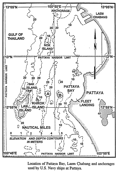
There is no commercial or military port at Pattaya. US Navy ships anchor in outer Pattaya Bay within the limits of Pattaya Harbor at approximately 12º56'N 100º51'E. Pattaya has no port facilities that are commonly available at other ports. Pilots and tugs are not required for ships visiting Pattaya. Liberty parties from visiting U.S. Navy ships are ferried to/from ship/shore by local commercial boats, which normally make the run in 15 to 18 minutes. Liberty parties of up to 10,000 personnel can be accommodated at Pattaya. A Fleet Landing is established on a pier that extends northwestward from the beach in the southern part of Pattaya Bay.
The commercial port of Laem Chabang, a developing deep water facility, is located approximately 8 nmi north of Pattaya. The first stage of a planned three stage development was in progress as of a March 1997 port visit. Five concrete berths, Berths A4 and B1 through B4, each with built-in rubber fenders, were completed and operating at the time of the visit. Berths B1 through B4 are 984 ft (300 m) long container berths. Alongside depth of a 164 ft (50 m) wide area running along the pier face of the B berths is 49 ft (15 m). The depth of the remaining area between the A and B berths is 46 ft (14 m). Because of their substantial construction and ample alongside depths, the B designated berths would be the most desirable for use by US Navy vessels, including aircraft carriers. Breasting barges are available to breast an aircraft carrier away from the pier face. The A designated berths are privately owned and designed for specific uses, ranging from handling bulk sugar and molasses to tapioca shipments.
There is no designated entrance channel for Pattaya. Approach to the anchorage areas can be made from the northwest or southwest. Vessels generally favor the approach from the southwest due to currents which generally set northeasterly. Currents up to 6 kt have been reported in the area. Caution must be exercised when using the approach from the southwest, as ships must pass between small islands and shoal water.
Laem Chabang Port is approached from the northwes. The 1.35 nmi (2.5 km) long, 503 yd (460 m) wide channel is marked by Buoys 1 and 2 at its seaward end (Hydrographic Department 1992). Buoy 6 marks the southeast end of the channel in its construction Phase 1 configuration. The channel will extend farther southeast as construction Phases 2 and 3 are completed. An entrance light buoy is situated approximately 0.7 nmi northwest of Buoys 1 and 2. The channel is dredged to 46 ft (14 m) (Laem Chabang Port, undated).
There is no specified anchorage at Pattaya. U.S. Navy aircraft carriers normally anchor at approximately 12º56'N 100º49'E in 69 ft (21 m) depths. Smaller vessels anchor in 49 to 52 ft (15 to 16 m) depths approximately 1 nmi east of the aircraft carrier anchorage. The approximate position of the anchorage used by smaller vessels is indicated by the circled letter B on Figure XVI-9. Holding in both locations is reported to be good on a sand bottom.
|
NEWSLETTER
|
| Join the GlobalSecurity.org mailing list |
|
|
|