

Tromelin Island (Ile de Sable)
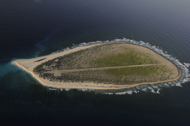
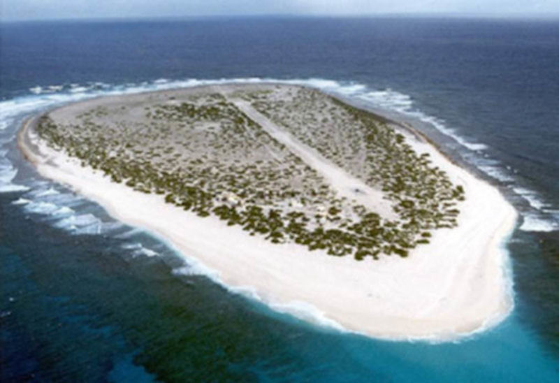
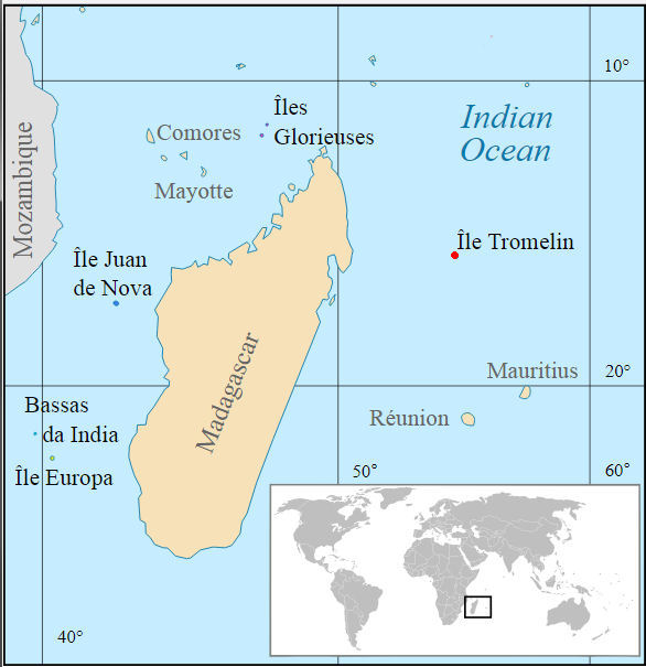
15°52' South 54°25 East Located in the Indian Ocean to the north west of Réunion and Mauritius, 560 kilometers from the Reunion and 450 kilometers from Madagascar, the island of Tromelin whose dimensions do not exceed 1.5 km in length Over 0.7 km wide and with a maximum altitude of 7 meters, inhabited only by scientific or meteorological missions, devoid of drinking water and swept by trade winds which render any culture impossible, can only be approached in particularly difficult conditions.
The island, as well as the vast exclusive economic zone (EEZ) surrounding it, is the subject of sovereignty disputes between France, which effectively occupies it and controls the EEZ, and Mauritius, which claims it and issued fishing licenses for its own EEZ, including that of Tromelin, which occasionally creates tensions between the two countries. Madagascar and Seychelles Islands also claim Tromelin.
Tromelin or Sandy Island was discovered by the ship La Diane in 1722, and called L'Ile de Sable. In 1761 the French transport L'Utile was wrecked on it, and eighty blacks, men and women, were left on it. Most of the slaves died within a few months. These all died but seven women, who lived chiefly on shell-fish and brackish water for fifteen years, till they were taken off by Captain Tromelin in 1776. His name has since been applied to the island.
Tromelin's controversial legal status is a complex issue of international law pivoted on the question of the island's status prior to 1814. These two governments have agreed to the principle of 'co-managing' (co-gestion) the island. Tromelin was first explored by the French in 1776 and it came under the jurisdiction of Reunion in 1814.
To establish its original sovereignty on the reef of Tromelin, France invokes in the first place and continuously the title of the geographical discovery in 1722 of this territory without master. French possession of Tromelin was interrupted by Britain which took control of the island in 1810.
It has been administered as a French overseas territory since the 1950s. Then in 1954, the British gave their consent to Frances effective control over Tromelin. In 1954, under the auspices of the World Meteorological Organization, and apparently with British consent, the French built a weather and communication center as well as a 1,100 meters landing strip. Since then, the island has been occupied by a small group of professional civil servants administerd from Reunion. France has effectively and continuously occupied Tromelin since May 7, 1954, the date of installation of the French teams of Météo France who have been permanently there under the authority of the prefect of Reunion and then the prefect of the TAAF. France intends to pursue this policy of permanent presence when it is no longer assured by Météo France.
In a 1978 unilateral decision, the French government announced the creation of 200 nautical miles Exclusive Economic Zone for all French islands or the Indian Ocean, including Tromelin. France established in 1976 (see Decree no. 78-146 of 3 February 1978, establishing, pursuant to the Act of 16 July 1976, an economic zone off the coasts of the islands of Tromelin, Glorieuses, Juan de Nova, Europa and Bassas da India.
In recent years tourist groups organized from Reunion have visited the island. Also young turtles are regularly taken from Tromelin, as well as from the Europa islands in the Mozambique channel, to a commercial experimental turtle farm on Reunion.
Mauritius is of the view that the assignment by the Treaty of Paris of the Isle of France (Mauritius) to the British Crown included Tromelin, so that upon reaching independence in 1968, Mauritius should have entered into possession of Tromelin. Mauritius considers that the Treaty of Paris of May 30, 1814, by which France ceded to Great Britain Mauritius and its dependencies included Tromelin and that it came into possession upon its accession to independence in 1968. Mauritius has officially claimed this islet since 2 April 1976.
France rejects the Mauritian argument, and of course holds a contrary view. At this stage, France has a de facto control or Tromelin but in 1982 announced its willingness to enter negotiations with Mauritius to determine its sovereignty. However, French commercial interests, particularly in Reunion, appear adamant that the island is French territory and will remain so.
Critics also point to the risk of creating a precedent that could be used to fuel arguments of those countries (Mauritius, the Comoros and Madagascar) which repeatedly dispute French claims of sovereignty over the other French-occupied Scattered Islands (Îles Éparses) of the Indian Ocean (Juan de Nova, Glorioso and Europa islands, the Bassas da India atoll, and the feature known as Banc du Geyser), and related maritime zones.
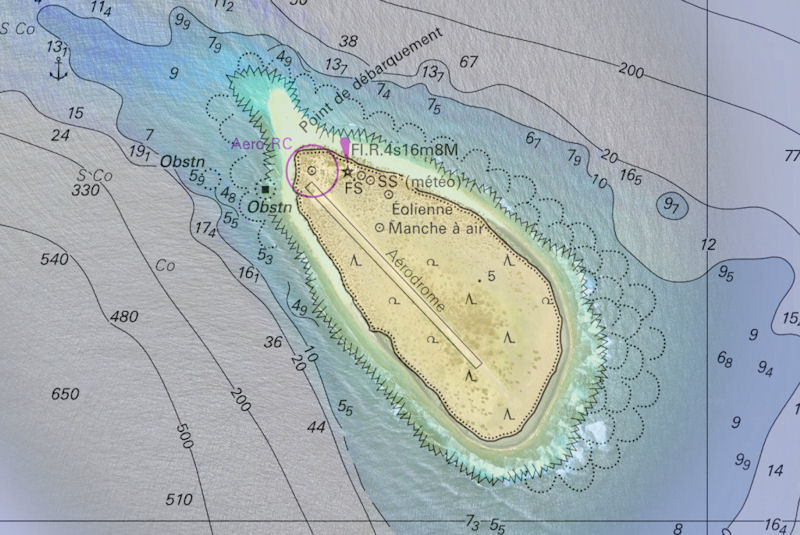
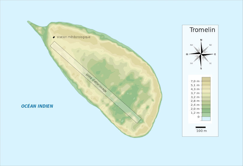
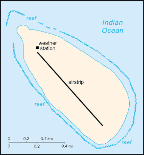
This solitary spot is about 240 miles eastward of Madagascar and nearly 300 miles from Mauritius. Tromelin consists of a mass of sand nearly a mile in length northwest and southeast, and about 800 yards wide. The northern part is 15 feet high and covered with bushes, the southern part is very low. The whole island is surrounded by a fringing coral ledge 150 yards wide, on which the sea breaks heavily. There is a small galvanized iron hut on the northeast end of the island.
It was at first described as a flat sandy spot, 15 ft. above water, half a mile long by a quarter of a mile broad, with a sand-bank projecting to the Indian Qeean. A later account by Captain Moresby, in 1822, makes it larger than this; and in October, 1851, Captain Parker, in H.M.S. Pantaloon, found that the shoal at the South end had grown up above the level of the sea, as it was then nearly steep-to, with the exception of a break at the S.W. corner, and a bank of soundings extending nearly one mile from the North end of the island. On this last, at three-quarters of a mile off shore, the soundings ranged from 7 to 12 fathoms, sand and large coral rocks, very indifferent holding ground; but with the S.E. monsoon it is under the lee of the island. In standing over the bank the bottom was clearly visible.
The island is surrounded by a coral ledge, on which the sea breaks heavily, and no boat can land except at a spot close to the eastward of the North point, which, although it is on the weather side, a landing may be at times effected at near high water. A bank of soundings over which there are 10 fathoms or less, extends half a mile southeastward and eastward, also 1 mile northwestward with depths of from 7 to 10 fathoms. On the latter, there is anchorage in 8 fathoms, sand and coral, under the lee of_the island during the southeast monsoon, but the holding ground is indifferent. Landing can only be effected on a steep sandy beach just eastward of the north extreme, and even there it should only be attempted near high water.
The northern half of the island is highest, and has a few bushes, with grass; the very low southern part has only grass. Some remains of old habitations stand on the highest part, and on the NW side are some iron guns, an anchor, and the iron-work of a wreck. A heavy race is caused off the northern extremity of Tromelin Island by the meeting of the ebb stream and the westgoing current; this often breaks so heavily as to be dangerous for boats at 400 or 600 yards from the shore. The island swarmed with sea-birds in the breeding season in October.
The other Tromelin Island [aka Peys island] is described as being 2 miles in circumference, and as differing from most of (he Caroline groups in having neither a lagoon nor fringing reef. The formation is madrepore rock, about 40 feet high at its north end. Being steep-to there is no anchorage; on the south-west side there is least surf, and the beach is sandy; landing is difficult. It is inhabited. The eastern extreme is charted in lat. 0°46'N.. long. 140°35'E. In 1828, Captain Legoarant de Tromelin discovered a small low island in lat. 9° 52' N., long. 140° 42 E., to which Adm. Krusenstern gave his name. It is said that it is 5 miles long and 2 miles broad. Captain Lutke examined it in 1828, and places it in lat. 9° 47' N., long. 140° 38' E., calling it Felt or Feys. The size he mentions was also very different from Captain Tromelin. He Lutke said : This island is remarkable, because it is the only one of the Carolines that has no lagoon ; it is formed of madreporic rocks, 30 ft. high, against which the sea beats immediately. It is four versls (2% miles) in circumference. There is no anchorage in any part. On the South side, where the coast is sandy, there is less surf. Landing was very diflicult here, and the natives were not so good sailors as in any other island of the archipelago. Bread-fruit trees were rare, but bananas were in tolerable abundance. Population was then 300.
|
NEWSLETTER
|
| Join the GlobalSecurity.org mailing list |
|
|
|