

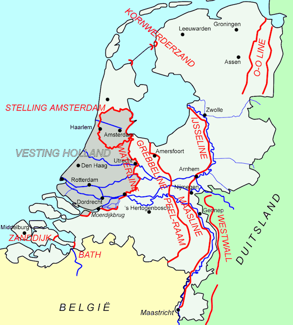
Water Line
The general character of the Dutch fortifications was determined by the peculiar conditions of time and place under which it was developed. Called upon to improvise defences, sometimes, as at Haarlem, with the enemy at their door, the Dutch could not look to masonry for security, or take the new citadel of Antwerp as then- model. But water was everywhere to their hand, and wide and shallow wet ditches, while constituting the best of obstacles, were also the readiest means of obtaining earth for the ramparts. High command was quite unnecessary for the latter, in so flat a country, and even harmful.
Holland is a land of about 8 1/4 million acres, divided into two almost equal parts-above and below high-tide level. The Dutch from time immemorial have been carrying on an unending battle with the sea. They have become expert in filching land from the grasp of the angry waters of the North Sea. Rather than to seek additional land by conquest of its neighbors it turned to the conquest of the sea.
The oldest European land reclamation occurred in the Netherlands. The first dikes consisted of raised trackways that joined farms with improved tracts of marshland. The farmers, realizing these raised trackways protected the land from encroaching salt water and general inundation, extended them to form a closed system of water defenses. Streams and ditches, which intersected the dikes, were closed by simple barriers that could be removed to release internal waters. The polders in the western Netherlands were drained between the 9th and 13th centuries. During the tenth century, sluice gates that closed automatically during high tides and floods replaced the manual barriers. Devices such as these are what made the concentrated effort to protect the Dutch countryside easier in the eleventh century. By the eleventh century, the Dutch concentrated their efforts on protecting lands within the salt marsh district from the temporary damage of sea floods and the encroachment of salt water inland. As a result, diking systems existed in many areas. These peat soils subsided 3 to 6 feet during 8 to 10 centuries (0.04 to 0.1 inch per year.)
The Dutch efforts to reclaim marshlands perpetuated many new ideas on that technology. By the nineteenth century, the Dutch had so advanced the techniques that they not only kept the sea from inundating dry lands, but also created 42,300 new acres of fertile farm land by draining Haarlem Lake through an immense system of canals and pumps. Upon completion of the project in 1852, 16,000 people occupied the land, producing much of the food for northern Holland.
In a country like Holland, where the Military System is built up solely with a view to protect the country from invasion, the defences must evidently occupy a position ot special importance. Thus the Dutch spent relatively large sums of money on fortifications, inundations and guns.
The whole country to the west of the line Naarden-Gcertruidenberg-Bergen op Zoom, and to the north of the West Scheldt, lies below the mean level of the Ij at Amsterdam, which is the datum level to which all heights are referred, and which is designated A.P. (Amsterdam peil.). The sole exception is formed by a narrow strip of sand dunes, which extend along the whole of the west coast, and have a relative altitude of from 35 to 70 feet above A.P. East of the line Naarden-Ueertruidenberg-Bergen op Zoom, and east of the Zuider Zee the ground rises to a maximum altitude of 150-300 feet above A.P., which, however, it only attains in a few places, the greater part of the eastern provinces being not more than 75 feet above A.P. The strip of ground between the south bank of the West Scheldt and the Belgian frontier has a level from A.P. to 3 feet above A.P.
The greater part of the low-lying country consists of polder land, i.e., land which has been reclaimed, and which is kept dry by means of steam pumps and windmills, the water being pumped into canals, protected by large dykes. The surface of the water in these canals is considerably above the level of the surrounding country. In the polders water is always very near the surface of the soil, and at certain times of the year the pumps are unable to keep the land dry.
The general appearance of a polder is that of a large field, containing frequently 300 or 400 acres, surrounded by a green bank, in some cases 20 or 30 feet in height, and intersected by numberless ditches from 3 to 10 yards wide, which cross each other usually at right angles. It would thus be exceedingly difficult for troops to move over such a district, even were it not inundated, while the dykes round the polders entirely prevent any view being obtained of the surrounding country. The roads run along the tops of the enclosing dykes, and it is almost impossible for anyone not a native of the country to cross a polder, or in any way to make a short cut.
The roads were of various kinds: (a) The 'straatweg,' which is paved either with stones or with tiles set on edge; this is an excellent road when in repair, but exceedingly trying to the feet, and generally about 12 to 15 feet in width; (b) Macadamized roads, of which there were few, since in most parts of the country there was no stone; (c) 'Grintwegen,' or gravel roads, which are fairly good in fine weather, but would soon be destroyed by the passage of artillery; (d) 'Landwegen' and 'kleiwegen,' which are merely tracks in sand or clay; these last are as a rule the only roads available between the dykes. Roads were, however, comparatively little used in Holland, the greater part of the passenger traffic being carried on by rail or tramway, while goods are principally transported by the canals. The polder land can be inundated by stopping the pumps and opening the sluices, and either fresh or salt water may be let in, according as the river and canal or sea sluices are opened.
|
NEWSLETTER
|
| Join the GlobalSecurity.org mailing list |
|
|
|