

The Martellus Map
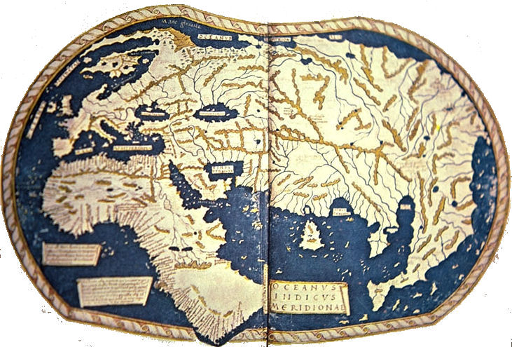 The map in which maritime exploration, prior to Columbus, is best expressed is that by Henricus Martellus Germanus. It was drawn in Rome in the year 1492 [though some sources date it as early as 1489 or as late as 1493], perhaps from information which had found its way thither from Portugal. Bartholomew Dias had rounded the Cape of Good Hope in 1487, and had charted the east coast of Africa as far as Rio do Infante. The map of Henricus Martellus Germanus, 1490 (?), is one which is almost contemporaneous with that expedition, and which, we may say, was based in part on the same. It expresses, in particular, the conception of the geography of Africa which was entertained as a result of the Portuguese expeditions in that direction. It seems to indicate that a waterway was open to India. For the student of Portuguese explorations it is a map of special importance, as may be seen in the nomenclature and in the legends.
Henricus Martellus was probably Heinrich Hammer and assuredly was of German birth, since the referred to himself as Germanus. He is a mysterious personality of whom no mention has ever been found except for the remarkable maps that he signed with his full name. It is established that he worked in Florence in the closing decades of the fifteenth century. He was the first mapmaker to append to the traditional maps illustrating Ptolemy a set of maps showing the world of his time, the tabulae modernae. These maps show the world on the eve of Columbus voyages; the continent of Africa as reported by the Portuguese, an open Indian Ocean, a jumbled but recognizable eastern coast of Asia, and Japan, identified as Zipango.
" ... by 1486 the mathematical junta had solved the problem of establishing latitude by measuring the height of the mid-day sun. The actual latitude of the Cape of Good Hope is 34° 22 south based on land measurements by Diaz, who landed three times on the south coast. Measurements of altitudinal height of the sun by astrolabe or quadrant were accurate on land but could be 2° or more out on the rolling deck of a ship. Yet the Martellus map shows South Africa extending across the frame of the map to 45° south. ... What purpose was served by extending Africa to 45° south? It was not to influence King John, who knew that the Cape was at 34.5° south. It was to influence the Catholic Sovereigns who were in the dark owing to the intense secrecy by Portugal regarding discovery. This suggests that the alteration was made in Seville. It suited Columbus admirably... Due south of the Malay peninsula, at 28° south, there appears an enormous peninsula which widens and turns north to join China again with the largely circular concept of the Fra Mauro map. It does not exist in fact... It is a relic of the continuous coastline that linked Southeast Asia to South Africa in Ptolemaic world maps... Although the Columbus brothers knew that Marco Polo had returned from China by this sea route, they inserted this great obstruction... "
The principal basis of Waldseemuller's large mappemonde of 1507 were no doubt the maps of Claudius Ptolemy, which Waldseemiiller knew from the Ptolemy edition published at Ulm in 1486. The Tabula modernce of the same edition gave him additional aid in the representation of Italy, Spain, France, and the territories of the North. Another source of information were the travels of Marco Polo, which he utilized for his designs of northern and eastern Asia as well as of the southern and eastern islands of Asia. In making his drawing of these territories, Waldseemuller also made use of a map on which all countries described by Marco Polo were represented just as on a map of the world by Martellus Germanus, or on the Globe of Martin Behaim.
|
NEWSLETTER
|
| Join the GlobalSecurity.org mailing list |
|
|
|