

Arabian Geography
During the course of the seventh and eighth centuries (roughly, between 622 and 750) the inhabitants of the Arabian peninsula burst the seclusion which they had held since the beginning, almost, of history, and, inspired by the zeal of the newly-founded religion of Islam, spread their influence from India to Spain, along the southern littoral of the Mediterranean. When they had once settled down, they began to recover the remnants of Græco-Roman science that had been lost on the north shores of the Mediterranean. The Arabs were acquainted with South-Eastern Africa as far south as Zanzibar and Page 61 Sofala, though, following the views of Ptolemy as to the Great Unknown South Land, they imagined that these spread out into the Indian Ocean towards India.
 Abu-Reyhan Mohammad El-Biruni was a native of Khwarizm, the modern Khiva, and was born in the year 973 AD. His greatest work is the "Vestiges of the Past," now translated (and previously edited in Arabic) by Prof. Sachau. Its value lies partly in the character of the author and partly in his time. The early date gives it an unusual worth, for the author was in possession of materials which were probably inaccessible to subsequent writers. Those most spoken of are the famous Canun-i Mas'udi, a geographical work frequently cited by Abu-l-feda, especially in his tables of Latitude and Longitude. He travelled into different countries to improve his knowledge, but judging from some errors which he has committed in his geographical description of India, it would appear that he never travelled to the east of Lahore. He wrote many works, and is said to have executed several translations from the Greek, and epitomised the Almagest of Ptolemy. He is perhaps wrongly credited with the first suggestion of the Deccan peninsula, so inconceivable to Ptolemy, but does not appear to dispute Ptolemy with respect to Africa. He died at Ghazneh in 1048, at the age of seventy-five.
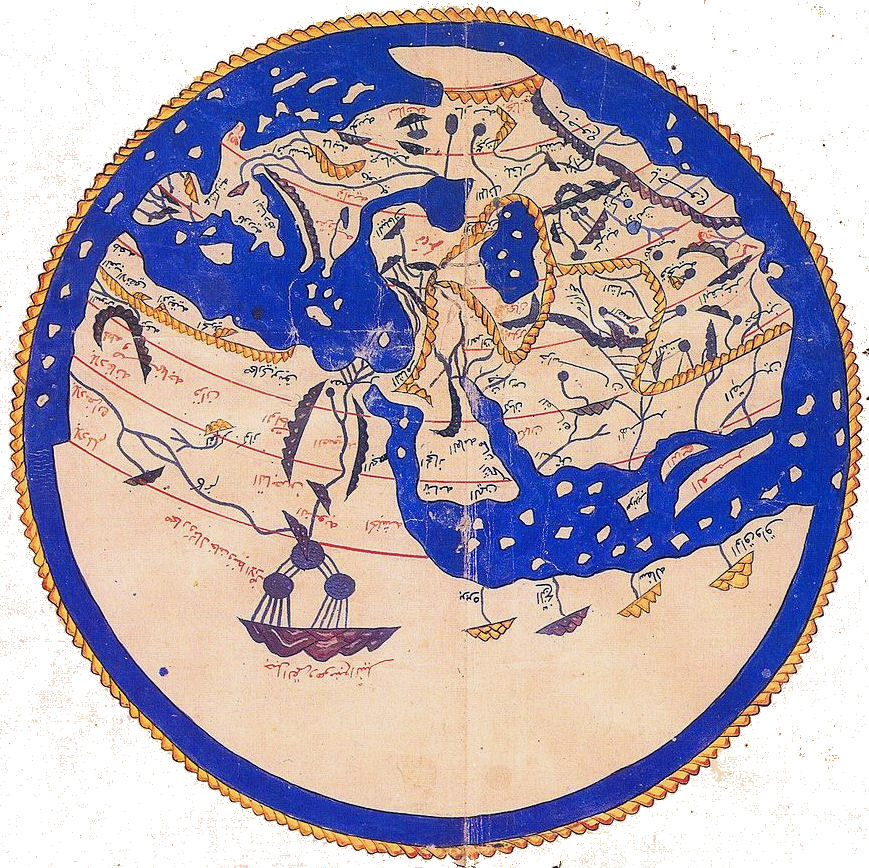 For in the generations immediately succeeding Al Biruni, the most active school of Mohammedan geography is to be found in the Far West. The Description of the entire Oikoumene attempted in the middle of the same twelfth century by Abu Abdullah Mohammed Ibn Idrisi, the 'Edrisi' of most European writers, is certainly the chief accomplishment of Western Islam, in all those departments of knowledge which may be grouped as 'geographical,' during the Crusading Age. Whether born at Ceuta or no, in or about 1090 or later; whether truly or falsely credited with personal travels in Southern and Western Spain, in various regions of Marocco and Algeria, in France, and even in England, Edrisi certainly seems to have resided in later life at the court of Roger II of Sicily, and to have composed his masterpiece under the patronage of the same prince, who created him a noble, and dispatched men even to remote Scandinavia to gather materials for his work. Edrisi was therefore in closer official relations with the men and thought of Christendom than most Arabic savants, and it is disappointing to find so few direct traces of his influence on European speculation and cartography, although in the world-maps of Marino Sanuto and Pietro Vesconte this influence is very apparent.
From a modern point of view Edrisi's Ptolemaic leanings give a markedly retrograde character to certain portions of his work, such as East Africa and South Asia. At the same time his encyclopaedic breadth of outlook, his clear recognition of scientific axioms which Latin geography was only beginning to admit, his extensive knowledge and intelligent application of preceding work, and the very considerable body of private and special information embodied in his own, must not be under-valued. Thus, on the shape of the world (remaining 'stable in space like the yellow in an egg'), he is perfectly satisfied with the 'opinions of most philosophers,' and believes it to be unquestionably spherical. The earth circumference is reckoned by Edrisi at 132,000,000 cubits; Eratosthenes, he admits, had made it one-twelfth more than this. His map, with all its shortcomings, is the most conspicuous, and perhaps the most satisfactory, product of that strangely feeble thing the early Mohammedan cartography.
The next two centuries are, in respect of individual accomplishment, the most brilliant in Mohammedan travel, if not in geographical inquiry. Thus, in the age of Saladin, Mohammed Ibn Jubair of Valentia, and Ali, son of Abu Bekr, surnamed Al Herawi, or the Man of Herat1 (to say nothing of the less noteworthy Valentian, Al Abdari. and the Sevillian, Al Arabi, younger contemporaries of Ibn Batuta and Edrisi respectively), rank as princes among Arabic explorers, the one for his exceptional qualities as observer and historian, the other for his inordinate energy and inquisitiveness. Still more remarkable, in its own way, is the work of Yakut Al Rumi, by birth a Greek slave, who has left (from the beginning of the thirteenth century) the delineation and description of Scandinavia, portions of the African coast, Egypt, Syria, Italy, France, the Adriatic shore-lands, and Germany.
Yet it is with the final re-settlement of Mohammedan Asia, with the permanent victory of Islam over Mongol heathendom to the west of the Gobi, that Musulman exploration and worldstudy reach their fulfilment; it is with the fourteenth-century encyclopaedia of ' Abulfeda,' with the work of Ibn Al Wardi and Ibn Khaldun, and above all with the journeys and narratives of Ibn Batuta, that 'Arabic1 geography utters its last word.
Abulfeda [or Abul Feda], known by the name of Ismael, prince of Hamah, in Syria, surnamed the victorious king, and the pillar of religion, was born at Damascus, in the year of the Hegira 672, AD 1273. This Arabian, famous as a historian and geographer, sprung from the family of the Ayubites, which had already given birth to the famous Saladin. From his uncle he inherited the principality of Hamah; but, on account of a quarrel with his brother, he did not come into possession of it for several years; after which he remained undisturbed therein till his death, in the year of the Hegira 732, AD 1333. He is a trustworthy author, and his style is good in several valuable works, of which his history of the human race, and his geography, entitled, The true Situation of Countries [Takweem al Boldan], are the most famous.
From what is set forth by this Author, who wrote a century and a half before the Portuguese discovery of the passage round the Cape of Good Hope; and probably from notices that had existed amongst the Arabs, for many ages prior to the date of his work; it appears, not only that the fact of Africa being surrounded by the ocean, was well known in the East, but the general form of that continent also. This applies with great force to the Portuguese scheme of discovery, as it can scarcely be doubted, that, even if copies of this author were not found in the libraries, in Spain and Portugal, yet that at least Prince Henry of Portugal, who had travelled in Mahomedan countries, and had read and inquired so much, with a view to promoting his favourite object of discovery, must have seen them.
|
NEWSLETTER
|
| Join the GlobalSecurity.org mailing list |
|
|
|