

Yunnan-Guizhou Plateau
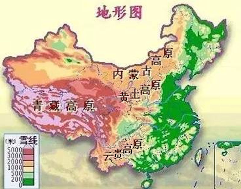 The four major plateaus of China are the Qinghai-Tibet Plateau, the Inner Mongolia Plateau, the Loess Plateau and the Yunnan-Guizhou Plateau. Covering east Yunnan Province and most parts of Guizhou Province, the Yunnan-Guizhou Plateau has an elevation of 1,000 to 2,000 meters. Covering 500,000 square km, Yunnan-Guizhou Plateau comprises east Yunnan Province and most parts of Guizhou Province. It has an elevation of 1,000 to 2,000 meters and a terrain that descends from the northwest to the southeast. It is covered with numerous valleys and small basins. Typical Karst topography, shaped by the dissolution of limestone rich in the region, is common on the plateau. The famous Huangguoshu Waterfall, largest in China, is on the plateau.
Located in the Southwestern frontier of China, Yunnan-Guizhou Plateau is characterized by its special environment and multiple ethnic groups, and has had a very special regional culture for a long period of time. The Warring States Period and the Qin-Han Dynasty was an important turning point in the local history. During this period, the bronze culture created by Southwestern barbarians was thriving, and at the same time, under the Qin and Han Empires expansion the region was colonized last and integrated as regional political units controlled by the central empire. This process resulted in great changes to local society and culture. Therefore the archaeological study of the Yunnan-Guizhou Plateau during the Warring States Period and the Qin-Han Dynasty holds an important meaning for constructing regional history, the formation and development of multi-ethnic China, and the expansion of Han culture.
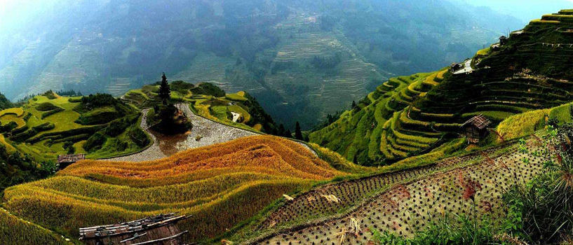
Guizhou is situated in the eastern part of the Yunnan-Guizhou Plateau in southwest China. In this land of towering mountains and deep valleys, there are over 300 basins which are wide in the middle and narrow at both ends. The average annual temperature is between 14°C and 16°C (54-56F) Eighty percent of Guizhou is mountainous. The plateau is intersected with mountains, hills, basins and valleys, giving it a very rugged, erosion formed topography. In many areas underground streams have carved the limestone into fantastic caverns.
 The highest point in Yunnan is the main peak of Meili Snow Mountain in northwestern Yunnan (6740 meters), and the lowest point is where Nanxi River in southeast Yunnan joins Yuanjiang (76.4 meters); the highest point in Guizhou is Jiucaiping (2900 meters) in northwestern Guizhou, the lowest point The point is the outflow of the Shuikou River in Diping Township, Qiandongnan Prefecture (147.8 meters). The relative elevation difference in Yunnan is also very large, especially in the Gaoligong Mountains and Wumeng Mountains, where the relative elevation difference can reach more than 4,000 meters; most areas in Guizhou are below 2,000 meters, and the relative elevation difference is relatively low.
The whole area of the lake region covers 1200 km2, accounting for 1.5% that of the national lake area. The ratio of lake surface to drainage area is 0.3%. On Yunnan-Guizhou Plateau, since the late Miocene Epoch, the new tectonic movement is strong, and the planation planes, high mountains, deep valleys and basins crisscross. These tectonic lakes, comparatively larger, are all distributed on the rift zone and drainage divide area of large basins, and arranged along the trends of folds and/or rifts. The axises of the lakes are usually the same as the deep fault trends.
Cangshan Mountain & Erhai LakeThe lakes in the region are mainly distributed in some faulted zones in the western and central Yunnan Province, and features relatively high elevation, precipitous lake banks, smaller area and deeper water The main lakes are Dianchi Lake, Erhai Lake, Fuxian Lake, Lugu Lake, Yangzonghai Lake and Chenghai Lake. Among them, the Fuxian Lake is 155 meters deep and it is the second deepest lakes in China. Owing to the relatively low latitude, the region belongs to the Indian monsoon climate district and the precipitation is mainly controlled by the summer monsoon (southwestern monsoon). Therefore, the wet and dry seasons are clear, and the precipitation between May and October accounts for more than 80 % of the total amount in a year. The lake water is mainly replenished by surface water and groundwater.
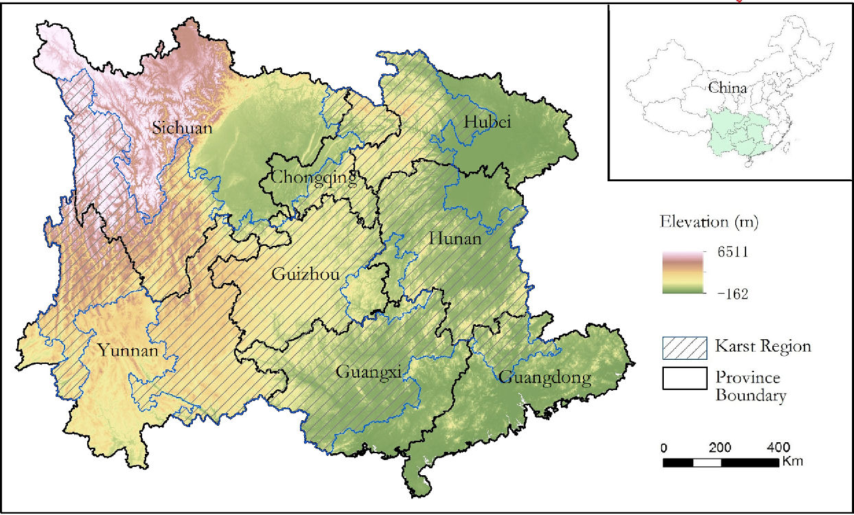 The rugged terrain, diverse ethnic species and wide distribution of karst landforms are the characteristics of the Yunnan-Guizhou Plateau. In fact, the Yunnan-Guizhou Plateau can be further subdivided into the Yunnan Plateau and the Guizhou Plateau, which are roughly bounded by the Wumeng Mountains running northeast to southwest. The complex topography and landforms of Yunnan have created diverse natural landscapes, such as snow mountains (Meili Snow Mountain, Yulin Snow Mountain, Biluo Snow Mountain, etc.), canyons (Nujiang Grand Canyon, Jinsha River Grand Canyon, etc.) Etc.), lakes (Dianchi Lake, Erhai Lake, Fuxian Lake, etc.), tropical rain forests (distributed in Xishuangbanna, Dehong, etc.), etc. The topography of Guizhou is relatively simple, mainly karst landforms, including Xingyi Wanfeng Forest, Wanfeng Lake, Dragon Palace, Zhijin Cave and other representative scenic spots.
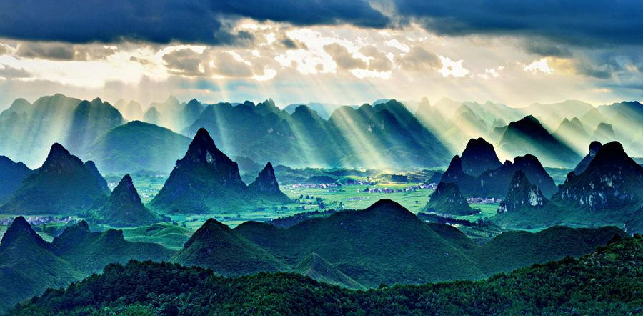
Southern China was submerged in an ocean billions of years ago, which was home to a large number of marine creatures. The deposit of their bones and other carbonate materials gradually built up a thick crust on the ocean floor, which rose up in later crustal movements to form land. Under a hot and humid climate, this region received high precipitation, which caused a chemical reaction on the carbonate rocks. The result is the marvelous landscapes seen today.
The flow of surface water carved grooves in the ground and these grooves grew deeper with the long passage of time, leaving the sections in between standing out like columns, 30-40 meters high. These columns often appear in large numbers, and are hence called stone forests. Stone forests are well developed clints. If the trees of such forests are connected at the bottom, they form a karst peak cluster. If further erosion cuts their base apart to make freestanding peaks, they are called tower karst and cone karst. In some places the erosion continued to the point that all but one karst peak was worn away.
 In 2007, the 31st session of the World Heritage Committee named South China Karst including Shilin in Yunnan Province, Libo in Guangxi Zhuang Autonomous Region, and Wulong in Chongqing Municipality a natural world heritage site. In 2014, the 38th session of the committee added four more sites to South China Karst Guilin and Huanjiang in Guangxi Zhuang Autonomous Region, Shibing in Guizhou Province, and the Jinfo Mountain in Chongqing Municipality.
Karst peaks and sweeping gorges that shape the special topography of Guizhou compel a growing number of visitors. Guizhou province's undulating topography has long sculpted its fight against poverty into an uphill battle in every sense-but the very mountains that had blocked prosperity are today generating it through tourism. Indeed, the sheer karst peaks, sweeping gorges and gushing waterfalls that shape this swath of the Yunnan-Guizhou Plateau in Southwest China have made transportation construction difficult. But their magnificent beauty compels a growing number of visitors. About 11.5 million people-a third of Guizhou's population-lived below the poverty line by the end of 2011, official figures show. The number dropped to 4.9 million by the end of 2015.
A new expressway on southwest China's Yunnan-Guizhou Plateau opened to traffic on January 4, 2019, facilitating trade and communication between provinces in the area. The 190-kilometer expressway links Liupanshui city and Weining county in Guizhou Province, shortening the journey between from the previous two hours to one hour. The expressway also shortens the journey from Liupanshui to Zhaotong city in Yunnan Province from the previous five hours to two hours. With an investment of about 25.3 billion yuan (3.68 billion U. S. dollars), the expressway, built in a mountainous area, has 157 bridges and 32 tunnels. According to Guizhou Expressway Group Co. Ltd., the expressway has an altitude ranging from 1,700 to 2,260 meters. Some of the expressway is equipped with a de-icing system and fog lights to ensure the safety of cars in extreme weather.
|
NEWSLETTER
|
| Join the GlobalSecurity.org mailing list |
|
|
|