

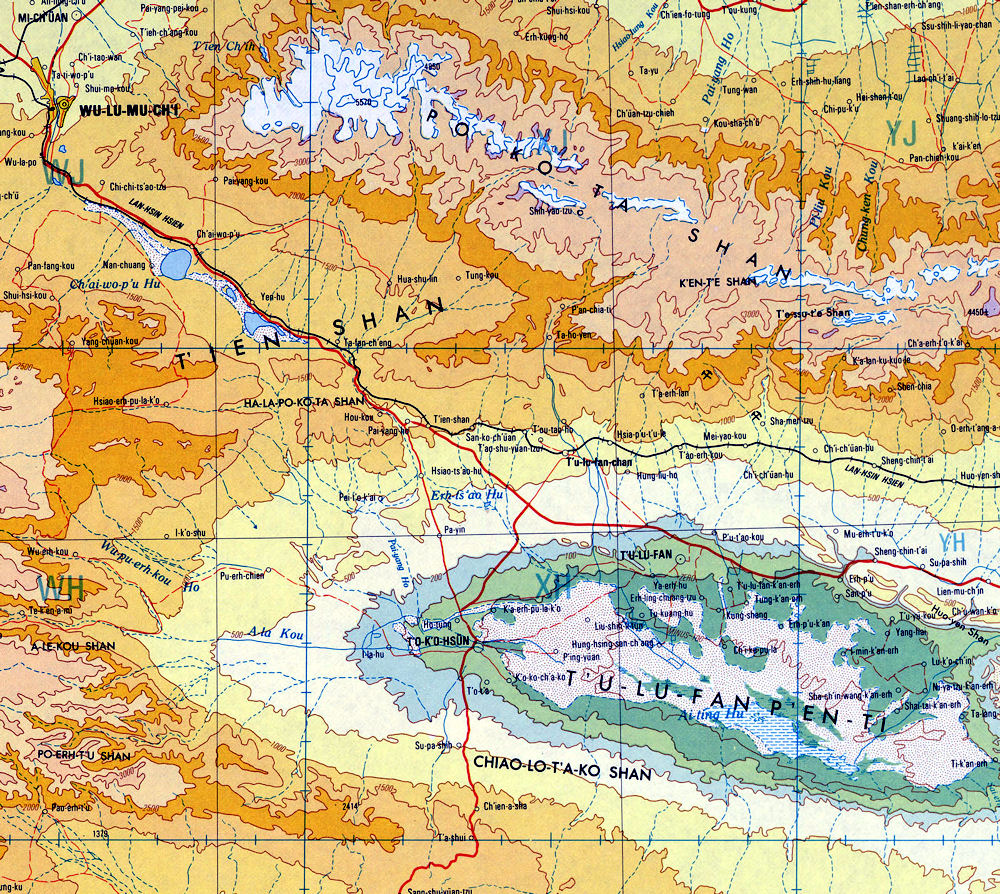
Turpan Basin
 The Turpan Basin is an intermountain basin on the southern slope of the eastern part of Tianshan Mountain, Xinjiang. "Turfan" means "low land" in Uyghur language. Turpan Basin is a typical graben basin, and it is also the place with the lowest terrain (-154.31 meters) and the highest summer temperature in China. Most of the ground does not exceed 500 meters above sea level. Since the 1980s, through the establishment of shelter forests and strengthening of irrigation management, sandstorms have been initially controlled and the ecological environment has improved.
The Turpan Basin is surrounded by mountains. The Turpan Basin is located near (90E°, 43N°). The Bogda Mountain in the north and the Karawucheng Mountain in the west are both 3500-4000 meters high. Among them, Bogda Peak is 5445 meters above sea level. The Jolotag Mountain in the south is generally below 1,500 meters. And close to the lowest part of the basin, the southern foothills of Aiding Lake surface is lower than the sea 154 meters, it is China's lowest depression.
Taking the surrounding ridgeline as the boundary, the area is 50,140 square kilometers, of which the area below sea level is 4,050 square kilometers, surrounded by mountains at the edge of the basin, and the highest peak, Bogda, is covered with snow all year round. There are two rows of east-west low mountains in the middle of the basin, with the Huoyan Mountain in the north, which is less than 900 meters, and the Jueluotage Mountain in the south, about 1,000 to 1,500 meters; there is an oasis between the two.
Huoyan Mountain is an alluvial fan at the southern foot of the Tianshan Mountains, with gravel Gobi and abundant groundwater. The Kanerjing (underground water diversion channel) began to divert water from then on. The rainfall in the basin is scarce. The average annual rainfall is 16.4 mm in Turpan city, 6.9 mm in Toksun city, 300-400 mm in the northern mountains, with snow at the peak, which is the main source of irrigation water for the basin. Therefore, the three main oases in the basin (Turpan, Shanshan, Tuo Kexun) are located in the north-central part close to the water source.
In order to improve the efficiency of water utilization, karez irrigation is mostly used. The basin is rich in light and heat resources, with more than 3,000 hours of sunshine per year, with an accumulated temperature of greater than or equal to 10°C, around 5000°C; summer is hot, with an average temperature of over 38°C from June to August.
The extreme maximum temperature in the suburbs of Turpan once reached 49.6°C ( measured at Turpan Airport on July 13, 1975 ). Rich in light and heat, the grapes, melons, and long-staple cotton are well-known products, and sericulture is also suitable for development. The basin is rich in oil and gas resources. The Lanzhou-Xinjiang-Xinjiang Railway passes through the basin, and the Southern Xinjiang Railway starts in Turpan and has been opened to traffic to Kashgar.
Turpan is an olive-shaped mountain basin in the eastern part of the Tianshan Mountains, surrounded by mountains on all sides. The basin starts from the mouth of the Alashan Gou in the west and reaches the west mouth of the Qijiaojing Canyon in the east. It is 245 kilometers long from east to west; in the north is the foothills of the Bogda Mountain; in the south reaches the Kurutag Mountain, with a width of about 75 kilometers from the north to the south.
Fossils of fish and dinosaurs from ancient times have been discovered here, proving that it was once a sea. Due to the movement of the earth's crust, it gradually turned into land and a basin began to form.
 The Turpan Basin has experienced the Jurassic, Cretaceous, Tertiary, and Quaternary in geological ages. It is an ancient basin that is gradually sagging, especially during the Himalayan orogeny 30 million years ago. The Geda Mountain rises sharply, while the Kuruktag Mountain on the northern and southern margins of the basin rises slightly. The two mountains break and sink, and finally form an asymmetrical basin with a high north and a low width in the west and narrow in the east. In the middle, there are Flaming Mountain and Bortoula Mountain, which traverse the territory, dividing the region into two halves, the north and the south.
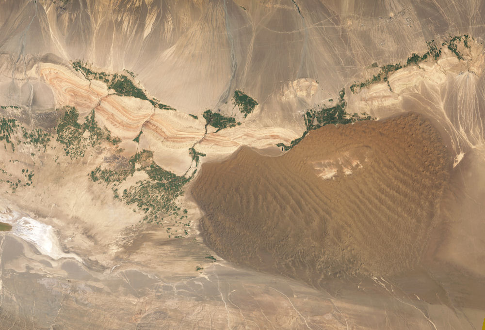
The water surface of Lake Aiding at the bottom of the basin, 154 meters below sea level, is the lowest basin in China. It is second only to the Dead Sea in Jordan, which is 391 meters below sea level, and the second lowest in the world. From a bird's eye view of the Turpan Basin, you can clearly see that it has a ring-shaped topography centered on Lake Aiding and consists of three ring zones.
The outermost ring is composed of high mountains and snow ridges, with Bogda Mountain in the north, towering into the clouds and snow-covered all year round; in the south there is the Kurutag Mountain; in the west there is the Karawucheng Mountain; in the southeast there is the Kumtag Mountain; It can be described as surrounded by mountains on all sides. The central ring of the basin is a Gobi gravel belt that has been eroded by mountains and ridges for a long time and has been transported by flowing water. The third ring zone of the basin is the most vigorous and attractive oasis plain zone.
Most of this area belongs to the slope of the mountain, with a large area of fine soil alluvial deposits. Because the Flaming Mountain lies in the center of the basin, the phreatic level is raised, and an overflow zone is formed on the north and south edges of the mountain, creating two oasis in the north and south., Became the foundation for the generations of people of all ethnic groups in the Turpan Basin to multiply and thrive. The mountain area of the Turpan Basin is 9,850 square kilometers, and the plain area is 59,863 square kilometers.
The Turpan Basin's climate is extremely dry, with very little rain, and the ability of water flow to naturally move objects is extremely poor. Therefore, the deposits in the basin are extremely small, which is an important reason. In addition, during the fourth neotectonic movement, a flame mountain was formed in the middle of the basin from east to west. Due to the barrier effect of this low mountain, the weathered material carried by the flowing water from the Tianshan Mountains can only accumulate in the north of the mountain, while the south of the mountain. It is protected from accumulation and has been kept below sea level for a long time.
The Turpan Basin has a special topography, surrounded by mountains. The main peak of Bogda Mountain to the north is 5445 meters above sea level. The Aiding Lake in the basin is -154 meters above sea level. Within such a short horizontal distance, the elevation difference is as high as 5600 meters.
Turpan Basin has a continental desert climate with aridity and hot weather. The annual precipitation is about 16 mm, and the evaporation is as high as 3000 mm. The highest summer temperature has a record of 49.6°C, and the average highest temperature from June to August is above 38°C. The temperature of the sand surface at noon is as high as 82.3°C, so it has been known as the " Fire Island " since ancient times.
The sunshine time is long, about 3,200 hours throughout the year, and the frost-free period is about 210 days. Due to the low pressure in the basin, which attracts airflow, it is also a well-known "wind reservoir" in China. The spring storm blowing in Dabancheng reached 50 meters per second, and the strong wind blowing from Qijiaojing overturned vehicles. Turpan Basin belongs to a unique warm temperate arid desert climate. The main features are: dry, high temperature and windy. In the basin, the annual sunshine hours are long; the evaporation is large; the precipitation is small but the locality is strong. To the south of Huoyan Mountain, summer is long and very hot, winter is less severely cold, and there is little wind and snow. The spring heats up rapidly and is unstable, dry and less rainy, and the wind is strong and strong. Autumn is high and fresh, with rapid cooling and large temperature differences. Compared with Shannan, the four seasons to the north of Huoyan Mountain are distinct, with more severe cold in winter, less hot in summer and more precipitation. The spring and autumn seasons are half a month longer than Shannan.
The groundwater resources in the basin are very rich, and its water source is mainly the melting water of snow and ice in the Tianshan Mountains. During the process of infiltrating into the basin through the underground coarse sand and gravel layer, the melted water is intercepted by the Huoyan Mountain, springs out of the ground in the valleys between the mountains, and merges into a river. Both sides of the river are idyllic and green, with beautiful scenery, rich in melons and fruits. The most famous fruit varieties are seedless white grapes and cantaloupe. The Grape Valley, located 10 kilometers northeast of Turpan City, has a long-standing reputation. The ditch is 7 kilometers long and about 2 kilometers wide. It traverses the Huosang Mountain, and the east and west mountain peaks face each other. The spring water in the ditch is happily flowing, and fruit trees grow thickly. It is refreshing and pleasant. Rows of towering white poplars are lush and lush, and the ditch full of slopes are stacked on top of each other. The bunches of grapes are as emerald-green and dazzling. They are known as "China's green pearl."
There are three main reasons for the summer heat in the Turpan Basin. The first is because the climate is particularly arid, there are no clouds in the sky to block the strong sunlight heat, and no water on the ground evaporates to consume heat, so the sunlight heat can be used to raise the temperature; the second is the Turpan basin topography, where the sunlight heat is not easy to radiate outside during the day. The third is the low altitude here, near sea level, which is the lowest place in the arid area of inland China. The lower the altitude, the higher the temperature, with an average rise of 0.6°C per 100 meters.
Turpan is the place with the least rainfall and the driest in China, and it is also one of the arid and driest areas in the world. The annual average precipitation is 16.4 mm, and the distribution is uneven, with large seasonal differences. The continuous precipitation is small and mostly intermittent. There are more mountainous areas than basins, and mountainous areas more than mountainous areas, which gradually decrease from north to south, and the number of days without precipitation is longer. At the same time, the inter-annual variability of annual precipitation is relatively large; the year with the most precipitation in the north of the mountain can reach 76.8 mm (Shanshan 1998), and the year with the least amount of precipitation is only 12.6 mm (Shanshan 1985); the year with the most precipitation in Shannan can reach 33.4 mm ( Turpan 1998), the smallest year was only 4.3 mm (Turpan 1976). The annual precipitation is the most in summer, followed by spring.
Turpan has strong solar radiation, long sunshine time and abundant light energy. The annual average total radiation is 5938.3 MJ/m2, the maximum annual radiation is 6397.0 MJ/m2, the minimum annual is 5648.2 MJ/m2, and the mid-year maximum is July. It is 680.3-800.2 MJ/m2, which is larger in spring than in autumn. The annual total sunshine hours averaged 3056.4 hours. The annual total sunshine hours reached 3349.6 hours at most and 2829.7 hours at least, and the annual sunshine percentage was 69%.
Turpan has a dry climate and strong evaporation capacity, with an average evaporation of 2837.8 mm. The characteristics of the evaporation change are: gradually increasing from north to south, and the evaporation is the most vigorous in the late spring and summer throughout the year, and the evaporation accounts for the whole from April to August. More than 75% of the year.
Turpan Basin is surrounded by mountains and low in the middle. The heat radiated from the surface is not easy to dissipate. It is a famous dry-hot area in China, with an extreme high temperature of 47.8°C in history. The basin is dry and less rainy, with 3,200 hours of sunshine throughout the year, an average annual precipitation of 16 mm, an annual evaporation capacity of more than 2539.4 mm, and a frost-free period of 210 days. There are 30-mile wind area and Baili wind area in the territory, known as the "wind reservoir". The superior light and heat conditions and unique climate make it rich in cash crops such as grapes, cantaloupe, and off-season vegetables. It is a veritable "hometown of melons and fruits". mineral resources.
Turpan is rich in mineral resources. 68 types of minerals have been proven, including coal, petroleum, natural gas, gold, iron, copper, Glauber's salt, granite, potash saltpeter, sodium saltpeter, bentonite and other minerals with large reserves, high grades, and great development value. potential. Among them: coal reserves are predicted to be 565.1 billion tons, Shaer Lake and Aiding Lake are both super-large monolithic coal fields with predicted reserves of more than 100 billion tons; total oil resources are 1.58 billion tons, and total natural gas resources are 365 billion cubic meters. ; The proved reserves of iron ore are 350 million tons, ranking first in Xinjiang, with 230 million tons of reserves; the proven reserves of potassium (sodium) saltpeter are 220 million tons, which is the world's largest resource of potassium (sodium) saltpeter; granite reserves are large and fine Good, with reserves of 8.179 million cubic meters, "Shanshan Red" has become a famous brand product in China; smectite mine is the only large-scale deposit in China; bentonite reserves rank second in Xinjiang, and it is one of the few sodium bentonites in China.
Wind is also one of the important natural characteristics of Turpan. The strong winds of the year occur from March to October, and the strongest is from March to June, especially in May. The wind direction is mainly northwest wind. Turpan's terrain is very different, with a large heated area and large temperature amplitude, which has led to windy weather. Gale winds are mainly affected by local and weather systems. The former winds are generally below level 10, with a short duration, and less harmful; the latter is fierce and lasts for a long time, and the wind is above level 10, which is serious. Turpan is rich in wind energy resources. Toksun weather station counts the number of days with gusts above level 6 (wind speed = 17.0 m/s). The annual average is 80.3 days. The maximum year was 127 days in 1985 and the minimum year was 35 days in 1997. In particular, Turpans tuyere is richer in wind energy resources. For example, the Baiyang River Valley from Dabancheng to Toksun is about 100 kilometers long and more than 10 kilometers wide. The narrow tube effect is significant. In addition, the strong pressure gradient inside and outside the basin is known as "wind". "Library". Therefore, Turpan has inexhaustible, inexhaustible, low-cost, non-polluting wind energy resources, and has practical development and application potential.
In Xinjiang, especially in the desert and Gobi areas, water is the source of life. The flowing water from the Kanerjing makes Turpan this land full of vitality. Here the solar radiation is strong, the temperature is high, and the heat is high.
Turpan's grapes are of good quality, especially seedless white grapes. Turpan has a long history of wine, where wine has been brewed as a tribute, thousands of miles, to the Central Plains, won general acclaim different. After conquering Gaochang, the famous Tang Dynasty general Hou Junji brought back the craftsmanship of making wine there. Li Shimin was very happy about this and made a little modification and brewed eight kinds of fine wines. After tasting them, the court officials were full of praise. Abundance is good for plant growth; the temperature difference between day and night is large, and the alienation effect is weak, so the varieties of long-staple cotton and melons and fruits produced are excellent. Especially cantaloupe and grapes are well-known at home and abroad.
Since the Western Han Dynasty, Turpan Basin has been one of the political, economic, and cultural centers of northwestern China. As Turpan Gaochang, Jiaohe, Bezeklik Thousand Buddha Caves, wins Chrysostom monastery ruins, caves and Royal Lake Sugongta ; Shanshan Tu Yugou grotto ; there Flaming Mountains, Edin Lake and other natural scenery and Karez. Drought and sandstorm are major disasters. Since the 1980s, through the establishment of shelterbelts and strengthening irrigation management, sandstorms have been initially controlled and the ecological environment has improved.
The peculiar Kanerjing : Turpan's unique natural conditions have forced the industrious and intelligent people living here to adopt a unique irrigation method-Kanerjing, which uses and transforms nature. The snowy peaks and glaciers on the Tianshan Mountains contain endless water resources, but when they melt into large rivers and wash down the valleys and enter the Gobi gravel belt in front of the mountains, due to the evaporation of the hot sun and surface leakage, Only a small amount of water reaches the downstream oasis. Kanerjing is a way to divert the phreatic flow that has penetrated into the ground out of irrigated by culverts. It is mainly composed of open channels, culverts and vertical wells. There are more than 1,000 Karez wells in the Turpan Basin with a total length of more than 3,000 kilometers. It is one of China's water conservancy projects.
|
NEWSLETTER
|
| Join the GlobalSecurity.org mailing list |
|
|
|