

China - Mountains
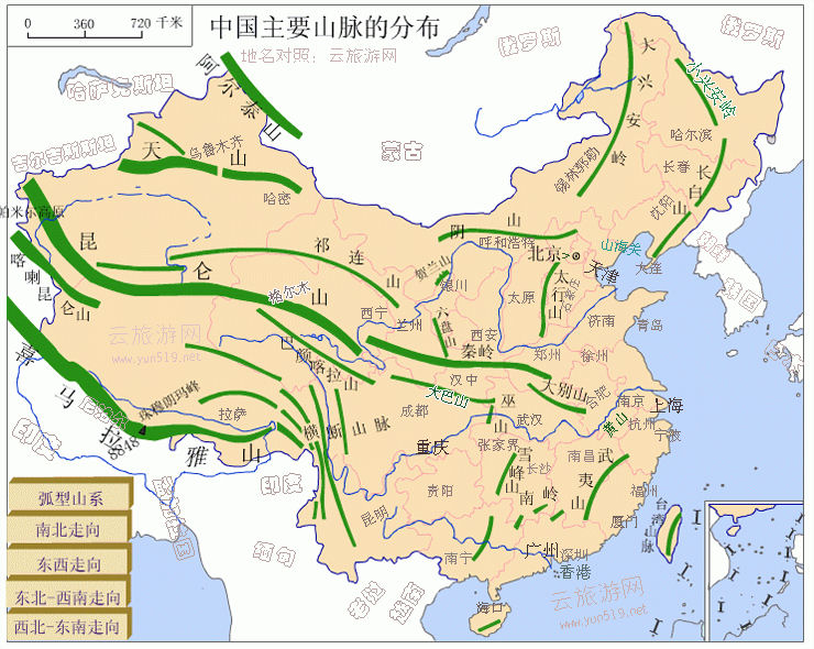 Mountains, hills, and highlands cover about 66 percent of the country's territory, impeding communication and leaving limited level land for agriculture. Most ranges, including all the major ones, trend eastwest. In the southwest, the Himalayas and the Kunlun Mountains enclose the Qing Zang Plateau, which encompasses most of Xizang Autonomous Region (also known as Tibet) and part of Qinghai Province. It is the most extensive plateau in the world, where elevations average more than 4,000 meters above sea level and the loftiest summits rise to more than 7,200 meters.
From the Qing Zang Plateau, other less-elevated highlands, rugged east-west trending mountains, and plateaus interrupted by deep depressions fan out to the north and east. A continental scarp marks the eastern margin of this territory extending from the Greater Hinggan Range in northeastern China, through the Taihang Shan (a range of mountains overlooking the North China Plain) to the eastern edge of the Yunnan-Guizhou Plateau in the south. Virtually all of the low-lying areas of China--the regions of dense population and intensive cultivation--are found east of this scarp line.
East-west ranges include some of Asia's greatest mountains. In addition to the Himalayas and the Kunlun Mountains, there are the Gangdise Shan (Kailas) and the Tian Shan ranges. The latter stands between two great basins, the massive Tarim Basin to the south and the Junggar Basin to the north. Rich deposits of coal, oil, and metallic ores lie in the Tian Shan area. The largest inland basin in China, the Tarim Basin measures 1,500 kilometers from east to west and 600 kilometers from north to south at its widest parts.
The Himalayas form a natural boundary on the southwest as the Altai Mountains do on the northwest. Lesser ranges branch out, some at sharp angles from the major ranges. The mountains give rise to all the principal rivers.
The spine of the Kunlun Mountains separates into several branches as it runs eastward from the Pamir Mountains. The northernmost branches, the Altun Shan and the Qilian Shan, rim the Qing Zang Plateau in west-central China and overlook the Qaidam Basin, a sandy and swampy region containing many salt lakes. A southern branch of the Kunlun Mountains divides the watersheds of the Huang He and the Chang Jiang (Yangtze River). The Gansu Corridor, west of the great bend in the Huang He, was traditionally an important communications link with Central Asia.
North of the 3,300-kilometer-long Great Wall, between Gansu Province on the west and the Greater Hinggan Range on the east, lies the Nei Mongol Plateau, at an average elevation of 1,000 meters above sea level. The Yin Shan, a system of mountains with average elevations of 1,400 meters, extends east-west through the center of this vast desert steppe peneplain. To the south is the largest loess plateau in the world, covering 600,000 square kilometers in Shaanxi Province, parts of Gansu and Shanxi provinces, and some of Ningxia-Hui Autonomous Region. Loess is a yellowish soil blown in from the Nei Monggol deserts. The loose, loamy material travels easily in the wind, and through the centuries it has veneered the plateau and choked the Huang He with silt.
Understanding the basic situation of the distribution of China's main mountain ranges has very important geographical significance. Because they are often the boundaries of different terrain areas and different climate areas. For example, the Taihang Mountains are the boundary between the second and third steps of Chinese terrain, the boundary between the Loess Plateau and the North China Plain, and the boundary between Shanxi and Hebei Province; the Hengduan Mountains are the boundary between the first and second steps of the topography of China. The boundary between the subtropical monsoon climate zone and the Qinghai-Tibet alpine climate zone, the Qinghai-Tibet Plateau and the Sichuan Basin and the Yunnan-Guizhou Plateau, the Tibet Autonomous Region, Yunnan Province, and Sichuan Province.
Nanling is the boundary between the tropical monsoon climate zone and the subtropical monsoon climate zone, and the tropical monsoon forest and subtropical evergreen broad-leaved Forest boundary, subtropical humid region of Central China and tropical humid region of South China, Jiangnan hills and Guangdong and Guangxi hills, the boundary between the Yangtze River and the Pearl River; Nushan is the boundary between the Pacific and the Indian Ocean, the boundary between Yunnan Province and the Tibet Autonomous Region, and the Nujiang and Lancang River watersheds.
|
NEWSLETTER
|
| Join the GlobalSecurity.org mailing list |
|
|
|