

Qaidam Basin
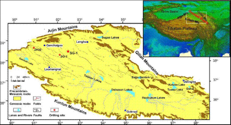 The Qaidam Basin is one of the three major inland basins in China, which is a closed and huge inter-mountain fault basin. Located in the northwest of Qinghai Province. Surrounded by Kunlun Mountains, Qilian Mountains and Altun Mountains, it covers an area of about 250,000 square kilometers. "Qaidam" is Mongolian, meaning "yanze".
The base of the basin is the Precambrian crystalline metamorphic rock series. The terrain is slightly inclined from northwest to southeast, and the elevation gradually drops from 3000 meters to about 2600 meters. The landforms are distributed in a concentric ring shape. From the edge to the center, the diluvial gravel fan (Gobi), alluvial-diluvial silt plain, lacustrine-alluvial silt clay plain, and lacustrine silt-salt-soil plains are distributed in a regular order. Change. Salt lakes and marshes are widespread in low-lying areas. On the inner edge of the Gobi belt in the northwest of the basin, there are clusters of hilly hills with a height of 100 meters or less. The southeast of the basin has drastic subsidence, and the alluvial and lacustrine plains are vast.
The main lakes such as South and North Horusun Lake and Dabson Lake are distributed here. There are large swamps along the lower reaches of the Qaidam River, Suringol River and Golmud River and around the lakes. Due to the uplift of a series of low-mountain fault blocks of metamorphic rock series in the northeastern part of the basin, a secondary small intermountain basin is formed between the basin and the Qilian Mountains. From west to east, there are Huahaizi, Dachaida and Xiaochaidan, Delingha and Wulan, etc. Basins, the rivers in these basins are injected into the lakes in their low-lying centers. Most of the rivers are intermittent. Among the 100 rivers, there are only more than 10 constant flow rivers, which are mainly distributed in the east of the basin, and the water network in the west is extremely sparse. Most of the lakes in the basin have been saline, and there are more than 20 large and small salt lakes.
The Qaidam Basin has a plateau continental climate, characterized by drought. The annual precipitation decreases from 200 mm in the southeast to 15 mm in the northwest. The average annual relative humidity is 30% to 40%, and the minimum can be less than 5%. The annual average temperature of the basin is below 5°C, and the temperature changes drastically. The absolute annual temperature difference can reach more than 60°C, and the daily temperature difference is often around 30°C. It can drop to below 0°C at night in summer. The wind is strong, and the number of strong wind days above grade 8 can reach 25 to 75 days. There can even be strong winds of 40 meters per second in the west, and wind erosion is strong.
 The natural landscape of the Qaidam Basin is arid desert, and the main soil types are salinized desert soil and gypsum desert soil. The latter is mainly distributed in the western part of the basin. Meadow soil and marsh soil are generally salinized. The vegetation is sparse, the species are simple, there are less than 200 species in total, mainly shrubs, semi-shrubs and herbs with high drought resistance ability, and there are many halophytes. The vegetation structure is simple, with a cluster of about 6/l0 composed of one or several species. In the piedmont alluvial fan and alluvial-diluvial plains, the desert vegetation communities composed of Ephedra sinica, Haloxylon ammodendron, and red sand shrubs are dominated; in salt marshes, salt lakes, and river banks, Cyperaceae densely grow to form grass hills. Among them, the dominant saline vegetations such as deep purple needle rush, scabrian grass, and Carex nigra; the periphery of salt lakes and marshes are dominated by reeds and Leymus chinensis.
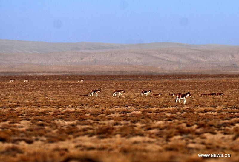
The fauna of the Qaidam Basin is characterized by the transition from the Mongolian-Xinjiang area to the Qinghai-Tibet area. Wild animals mainly include wild camels, wild donkeys, wild yaks, yellow sheep, green sheep, marmots, wolves, horse bears, deer, foxes, and badgers. Due to reclamation and hunting, wild animals have been greatly reduced, and some are endangered.
The Qaidam Basin is known as the "cornucopia". There are more than 200 proven mines with more than 50 types of mines. Among them, the reserves of salt, petroleum, lead, zinc and borax are particularly abundant, and the total reserves of salt are about 60 billion tons. Glauber's salt, potassium salt, and borate have industrial mining value. For example, the Chaerhan Potash Factory has become an important chemical raw material base in China. Oil storage structures are widespread in the basin, and there are important oil and gas accumulation zones in the west. The Xitieshan lead-zinc mine is one of the largest known lead-zinc mines in China. The existing arable land in the basin is concentrated in the east and southeast oasis areas, mainly producing grain and oil, with high yields.
The transportation industry has begun to take shape, the Qinghai-Tibet Railway has been opened to traffic, and the highway has initially formed a network. A number of emerging towns such as Golmud City, Lenghu Town, Dachaidan Town and Mangya Town appeared.
|
NEWSLETTER
|
| Join the GlobalSecurity.org mailing list |
|
|
|