

Pearl River Delta Plain
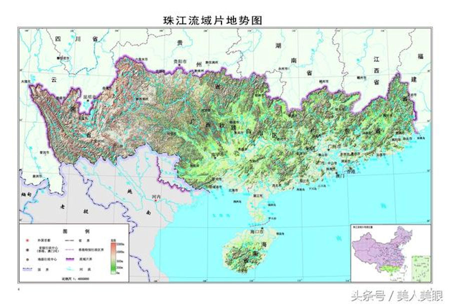 earl River Delta Plain, situated in the central-south of Guangdong Province, covers 11,000 square km, with an average elevation of around 50 meters. It has crisscrossing rivers and is dotted with isolated hills. The Pearl River is the second largest river in China. The annual runoff of the river is more than 349.2 billion cubic meters, ranking second in the country's river system, second only to the Yangtze River, and 6 times the annual runoff of the Yellow River. With a total length of 2,320 kilometers and a drainage area of about 440,000 square kilometers, it is the third longest river in China. The Pearl River Delta, formed by the scouring and deposition of the Pearl River system, has now become one of the three regions with the largest concentration of population, the strongest innovation capabilities, and the strongest comprehensive strength in China.
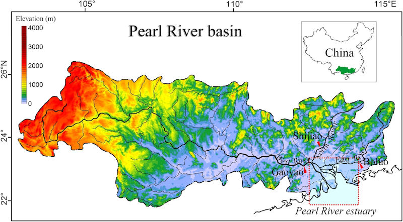
The Pearl River is different from the Yangtze River and the Yellow River. The Pearl River refers to the Pearl River system, not just a river. The Pearl River is a composite water system formed by the convergence of the West River, the North River, the East River and the Pearl River Delta). The Pearl River is composed of four water systems: Xijiang, Beijiang, Dongjiang and the rivers of the Pearl River Delta. It is distributed in the six provinces (autonomous regions) of Yunnan, Guizhou, Guangxi, Guangdong, Hunan, and Jiangxi in China and the northeast of the Socialist Republic of Vietnam. The main stream of the Pearl River is the Xijiang River, which originated from Ma Xiong Mountain in Yunnan Province and flows into the South China Sea at Modaomen in Zhuhai City, Guangdong Province, with a total length of 2214km. The whole basin covers an area of 453,700 km2, of which 442,100 km2 in China.
Among all the water systems of the Pearl River, the longest and largest is the Xijiang River, with a total length of 2,214 kilometers and a catchment area of about 353,120 square kilometers. As far as the Xijiang River is concerned, it is the fourth longest river in China after the Yangtze River, the Yellow River and Heilongjiang. The shipping volume ranks second in China, after the Yangtze River.
 PThe Pearl River Basin is located in the subtropical zone, with a mild climate and abundant water resources. The average annual runoff for many years is 336 billion m3, second only to the Yangtze River, and second in China. The average annual precipitation for many years is 1477mm. In the flood season, the precipitation intensity is high and the confluence speed is fast, which is prone to form basin floods with large peak heights and long durations, posing a serious threat to the economically developed lower reaches of the Pearl River and the delta. During the dry season, there will be no or little rain for three consecutive months, causing spring or autumn drought.
The Pearl River is a low-sand river with an average sand content of only about 0.25kg/m3 for many years. The river has abundant water volume, is relatively stable, and has good navigation conditions. The main stream of the Xijiang River runs through the four provinces and autonomous regions of Yunnan, Guizhou, Guangxi, and Guangdong, and is the main water transport artery in the east-west direction of the river basin. The communicated Nanning-Guangzhou waterway is the main trunk line of water transportation in the basin. The Pearl River Delta has criss-crossed waterways and can go out to sea through eight gates. The Pearl River water transport hinterland is vast and rich in resources. The ports of large and medium cities such as Guangzhou, Nanning, Liuzhou, Wuzhou, and Jiangmen are distributed along the main water transport trunk lines, which is conducive to the development of shipping.
The Pearl River Basin has 72 million mu of arable land in China. In 1985, the population was about 77 million, and the average per capita was only about 0.9 mu of arable land. There are more people and less land. However, it is unique in terms of water volume, sunshine, and accumulated temperature. It is an important rice and sugar production area in China, as well as a subtropical and tropical crop cultivation area. There are a lot of tidal flat resources along the coast. There are many types of mineral resources in various regions and large reserves. Famous ones are: Gejiu Tin Mine in Yunnan, Liupanshui Coal Mine in Guizhou, Guangxi Pingguo Aluminum Mine, and Yunfu Pyrite Mine in Guangdong. There is also abundant oil and natural gas outside the Pearl River Estuary. Large and medium cities such as Guangzhou and Nanning, as well as Shenzhen and Zhuhai Special Economic Zones also have a good foundation for industry.
|
NEWSLETTER
|
| Join the GlobalSecurity.org mailing list |
|
|
|