

Northeast China Plain
 Due to the ups and downs of the earth's land surface, various terrains are formed. The basic terrain types include plains, hills, mountains, plateaus and basins. Plain refers to an area with an elevation of 200 meters or less, with little undulations on the surface, and a flat and broad area. The topography of the plain occupies about one-third of the total land area. The plains are mostly distributed in the middle of the continent, with North America, South America and Australia being the most prominent. Asia is the largest continent in the world, with a total area of about 44 million square kilometers, accounting for about one-third of the world's total land area. Plain terrain is also widely distributed in Asia.
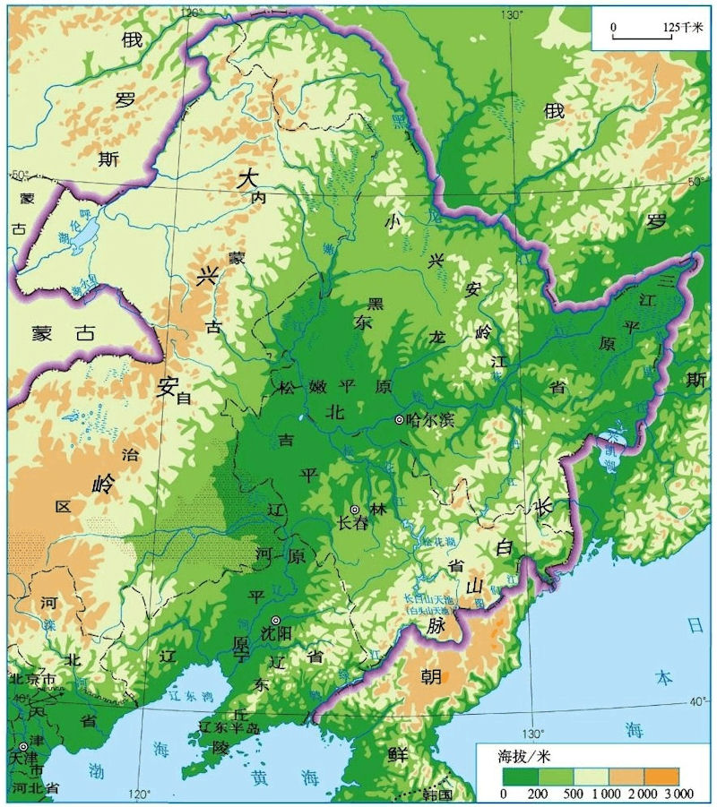
Northeast Plain, also known as the Songliao Plain (generalized), Northeast Plain is one of China's three major plains, is also China 's largest plain, located in China northeast of the Sanjiang Plain, Songnen Plain, Liaohe Plain composition across Heilongjiang, The four provinces of Jilin, Liaoning and Inner Mongolia are located between the Daxing'an Mountains and the Changbai Mountains, starting from the middle reaches of the Nenjiang River in the north, and to the Liaodong Bay in the south. km. Northeast China Plain in temperate and warm temperate range, and has a continental monsoon climate. The summer is short and warm and rainy; the winter is long, cold and less snowy. The monsoon alternates between winter and summer. The average temperature in July is 21~26°C, and the average temperature in January is -24~-9°C. The annual precipitation is 350-700 mm, decreasing from southeast to northwest.
The Northeast Plain is located between 40°25'~48°40' north latitude and 118°40'~128°00' east longitude. It is located in northeastern China, and its west, north and east sides are respectively surrounded by the Daxinganling and Changbai Mountains. The Northeast Plain spans the four provinces of Hei, Ji, Liao and Inner Mongolia. It is located between the Daxing'an Mountains and the Changbai Mountains. It starts from the middle reaches of the Nenjiang River in the north and reaches the Liaodong Bay in the south. It is about 1,000 kilometers long from north to south, and about 400 kilometers wide from east to west, an area of 350,000 square kilometers, is in Mongolia and Russia economic corridor one of the main channel, located in Northeast China and Japan and South Korea with northeast Asian economic zone.
Northeast Plain fertile land, is one of only three global black soil one area, the four northeastern provinces (regions) of grain production accounts for one third of China's total production, is China's major grain, soybeans, livestock industry production base, but also China An important coal, steel, machinery, energy, and chemical base. Northeast Plain stuff is located in Daxing loose Ann Ridge and Xiaoxing'anling, Zhangguangcailing - Changbai between, it is the largest in the Northeast Cenozoic continental rift - depression sedimentary basin ( Songliao Basin ). It is adjacent to the Zhangguangcailing fold belt in the east, adjacent to the northern margin of the North China block in the south, and Mongolia -Xing'an fold belt in the west. Peripheral faults in the basin and concealed fault structures within the basin are developed, and the north-north-east-trending lithospheric faults in the basin are the main body, which controls the formation and distribution of the basin.
The Liaohe River and Songhuajiang River flow through the north and south of the plain, and the Songliao Watershed is located between the two major river systems. In terms of topography, the Northeast Plain is divided into three parts: the Songnen Plain formed by the alluvial accumulation of the Songhua River and the Nenjiang River and its tributaries in the north ; the Liaohe Plain formed by the alluvial water system of the Liaohe River in the south ; and the Songliao Watershed in the middle.
The black soil is distributed in the mountain front land and plain in the southern part of the Xiao Hinggan Mountains, spreading south to the west slope of the middle section of the Changbai Mountains, and north to the mountain front land and plain in the northeast slope of the Da Khingan Mountains. The total area is 6.1 million square kilometers, and it is distributed on the plateau 55. %, 26% in the plains, 19% in the hills and mountains; 71% in the Songnen Plain, 7% in the Sanjiang Plain, and 3.3% in the Liaohe Plain.
Songnen Plain, the eastern part is mainly black soil, distributed in the foreground to the mountain plains and terraces, distributed in an arc from north to south; Songnen Plain west mainly chernozem, meadow soil. In the Liaohe Plain, meadow soil - fluvo-aquic soil is mainly distributed. The distribution of sandy soil is the widest in the west of the plain. There are salty soil and marsh soil along the coast.
The Heilongjiang River spans China, Russia, and Mongolia, with a total length of 4,370 kilometers (with the Hailar River as its source) and a drainage area of 1.84 million square kilometers, ranking tenth in the world. The drainage area in China accounts for about 48% of the total drainage area.
The Ussuri River is Heilongjiang's major tributary, the main confluence of the Ural River and River Road ratio is made to flow to the northeast of Khabarovsk area emergency turning southwest, into the Heilongjiang. The Ussuri River has a total length of 890 kilometers and a drainage area of nearly 190,000 square kilometers. Since its tributaries Songacha River at the date of the inflow to the river and Heilongjiang confluence place only, is China and Russia 's border.
The Yalu River is the boundary river between China and North Korea, named Ma Zishui in ancient times. It is called the Yalu River because of its dark green color like a duck's head. Originating from the Baitou Mountain in Jilin, it flows from the northeast to the southwest, and finally into the ocean at Donggou in Liaoning Province. The main stream is almost the natural border between China and North Korea. It has a total length of 795 kilometers and a total drainage area of 163,788 square kilometers, including 325,79 square kilometers in China. The annual runoff is 32.76 billion cubic meters.
Oil is the most important mineral resource in the Northeast Plain. In the northern part of the plain, due to the uplift and shrinkage of the basin, huge thick sediments were produced, which provided favorable conditions for oil production. The three major oil fields located on the Northeast Plain are Daqing Oil Field, Jilin Oil Field and Liaohe Oil Field. In addition to rich petroleum resources in the Northeast Plain, mineral resources such as coal, gold, limestone, and agate have considerable reserves and high grades. As of 2008, the proven coal reserves are 150 million tons, the prospective reserves are 248 million tons; the proven gold reserves are 15.4 tons, and the prospective reserves 58.7 tons; the limestone reserves are more than billions of tons, providing favorable conditions for the development of mining and processing of minerals.
The Northeast Plain is located in the temperate zone and warm temperate zone. It is located at the northernmost end of the East Asian monsoon. It belongs to a temperate continental monsoon climate. It is a transitional zone between Chinas humid eastern monsoon region and arid inland. It is hot and rainy in summer, cold and dry in winter, and continental. The climate is getting stronger from east to west. The four seasons of the year are distinct, with warm and rainy summers and cold and dry winters. The average temperature is 21~26°C in July and -24~-9°C in January. The active accumulated temperature above 10°C is 2200~3600°C, decreasing from south to north. The annual precipitation is 350-700 mm, decreasing from southeast to northwest. 85-90% of precipitation is concentrated in the warm season (May-October), and the peak of rainfall is in July, August, and September. The annual precipitation variability is small, about 20%. Dryness increases from southeast to northwest.
The Northeast Plain is a key forest area in China, with 43.93 million hectares of forest land and a total forest reserve of 3.7 billion cubic meters. The wood species in the northeast forest area is complete, the quality of the wood is good, and there are more than 100 kinds of trees. There are more than 1,000 species of wild animals in the region. In addition to more than 30 rare animals such as flying dragons, eagles, swans, Siberian tigers, deer, and sables, forest frogs and sable chickens with higher economic value are also included.
|
NEWSLETTER
|
| Join the GlobalSecurity.org mailing list |
|
|
|