

North China Plain
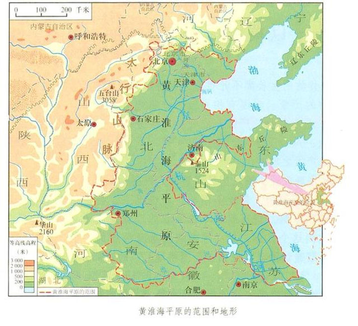 The North China Plain is an important part of the Great Plains in eastern China. Also known as Huanghuaihai Plain. It is located at 32°~40° north latitude and 114°~121° east longitude. It reaches the southern foot of Yanshan Mountain in the north, Dabie Mountain in the north, Taihang Mountain and Funiu Mountain in the west, Bohai Sea and Yellow Sea in the east, and spans 7 provinces and cities of Beijing, Tianjin, Hebei, Shandong, Henan, Anhui, and Jiangsu, covering an area of 300,000 square kilometers.
The plain is flat, with numerous rivers and lakes, convenient transportation, and developed economy. It has been the political, economic, and cultural center of China since ancient times. The population and cultivated land area of the plain accounted for about one-fifth of China. Beijing, the capital of China, is located in the northern part of the Great Plains. The North China Plain is a Cenozoic faulted area on the North China continental platform. In the Late Tertiary and Quaternary Periods, a contiguous large plain was formed. At the same time, the fault block mountains on the edge of the plain were relatively uplifted, and the outline of the large plain became increasingly sharp. The Cenozoic was relatively sinking and accepted thicker deposits, with local deposits reaching kilometers.
The North China Plain is less than 100 meters above sea level, and the terrain is gently sloping. From the foothills to the coast, there are landform types such as alluvial sloping plains, alluvial-alluvial fan-shaped plains, alluvial plains, alluvial-lacustrine plains, marine-alluvial plains, and marine plains. The landforms shaped by the Yellow River, Huaihe River, Haihe River, Luanhe River and other rivers constitute the main body of the North China Plain, namely the Yellow River alluvial fan plain; the middle and lower Huaihe plain; the middle and lower Haihe plain; the lower Luanhe alluvial fan plain.
The Yellow River formed a huge alluvial fan below Mengjin, with the fan margin facing east to the west of the mountainous hills in southwestern Shandong. The central axis of the alluvial fan of the Yellow River is highly silted, forming a "water ridge" on the North China Plain, separating the two major water systems of the Huai River and the Hai River from the north to the south. During the historical period, the Yellow River moved frequently, and the vast plains from the north to Tianjin, the south and northern Jiangsu were all affected by the Yellow River. The Yellow River alluvial fan still retains a large number of sand hills, depressions, old roads and other topography left by the breach and diversion. It is distributed between the front edge of the alluvial fan of the Yellow River and the mountains in southwestern Shandong.
The North China Plain is mainly formed by the alluvial deposits of the Yellow River, Huai River, Hai River and Luan River. The Yellow River is the largest river in the plain. It enters the plain with wide river channels and serious siltation. The Yellow River below Huayuankou is called "the river above the ground". Although the Yellow River is the second longest river in China, its water volume is only 1/20 of that of the Yangtze River, and the annual and inter-annual changes in flow are very large. The lower Yellow River naturally traverses the middle part, and is divided into two parts: the Huanghuai Plain to the south and the Haihe Plain to the north. Over the past century, the Yellow River has reclaimed an area of 2,300 square kilometers here. The plain also continues to extend to the ocean, the fastest being the Yellow River Delta, with an average of 2 to 3 kilometers per year.
The terrain is low and flat, most of which are below 50 meters above sea level, and the eastern coastal plain is below 10 meters above sea level. Slightly inclined from west to east. It is mainly a huge depression in the Cenozoic, with a deposition thickness of about 1,500 to 5,000 meters. The plains are mostly low-lying land, lakes and marshes. It is concentrated between Baoding and Tianjin Dagu, north of the alluvial fan of the Yellow River. Due to the large amount of sediment carried by the Yellow River, the Yellow River bursts, floods, and changes its course frequently. After 1949, reformation was carried out. Due to increased evaporation in spring, less precipitation, less river runoff, and man-made reasons, the North China Plain often suffers from spring droughts.
The zonal soil of the North China Plain is brown soil or brown soil. Plain farming has a long history, and various natural soils have been matured into agricultural soils. From the foothills to the coast, the soil has changed significantly. Loess (cinnamon soil) or tidal loess soil (meadow cinnamon soil) is developed along the piedmont alluvial fan or piedmont slope along the edge of Yanshan Mountain, Taihang Mountain, Funiu Mountain and Shandong Mountain. There are other soils on alluvial plains, such as aeolian sandy soil along the floodways of the Yellow River, Zhang River, Hutuo River, Yongding River, etc.; there are saline-alkali soils or swamps around river depressions, fan-front depressions, and lakes. Soil; the Huaibei Plain south of the alluvial fan of the Yellow River is not covered by yellow flooding sediments, and a large area of the ancient dry farming soil before the yellowing occursshajiang black soil (blue-black soil); south of the Huaihe River, northern Jiangsu, and southeastern mountains There are still paddy soils in the four lakes and the lower reaches of the Haihe River. Yellow fluvo-aquic soil is the most important arable soil in the North China Plain, with good cultivability, rich mineral nutrients, and great potential for utilization and transformation. The coastal area in the eastern part of the plain is a coastal saline soil distribution area, and the saline fluvo-aquic soil is formed by reclaiming salt.
After the founding of New China, the North China Plain developed rapidly. It has become one of the economically developed regions in China. The plains and adjacent areas are rich in coal, iron, and petroleum deposits. Coal, electric power, petroleum, chemical, steel, textile, food and other industries occupy an important position in China. There are large coal mines such as Kailuan, Fengfeng, Xuzhou, Huainan, and Huaibei. Shandong's Shengli Oilfield produces annual crude oil second only to Daqing Oilfield.
The North China Plain, with Beijing as the center, communicates with all parts of China through the railway, highway, and air transportation network. The plains are densely populated. Except for Beijing and Tianjin, there are more than 20 large cities with a population of more than 1 million. The output of grain and cotton in the North China Plain has accounted for 18.4% and 40% of China's total output respectively, and the role of oil plants also accounts for a large proportion in China.
|
NEWSLETTER
|
| Join the GlobalSecurity.org mailing list |
|
|
|