

Liaoxi Corridor
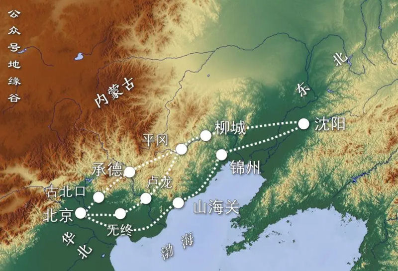 The Songling Mountains have an average elevation of 400-500 meters, winding through Suizhong County, Xingcheng City and the north of Jinxi City, northwest of Jinxian County and west of Yixian County. It happened to be northeast-southwest, almost parallel to the coastline of the Bohai Sea, thus forming what is called the "Liaoxi Corridor". It is a long and narrow coastal plain between Shanhaiguan and Jinzhou, with the Bohai Sea Liaodong Bay in the south and the Songling Mountains in the north. It is about 185 kilometers long and 8 kilometers to 15 kilometers wide. West Liaoning refers to the area west of Yiwulu Mountain, south of Xila Mulun River, north of Yanshan Mountain, and east of Qilaotu Mountain. It is located at the junction of Hebei, Liaoning, and Inner Mongolia. The "Liaoxi Corridor" is the main way to communicate with the hinterland of the Central Plains here and even in the Northeast.
As the main link between the Central Plains and North China, the Northeast and Mobei, the Liaoning West Corridor was the only way to travel between the Northeast and the Central Plains as early as the Shang and Zhou dynasties. For thousands of years, the Central Plains civilization continued to enter the Northeast through the Liaoxi Corridor. Since the end of the Eastern Han Dynasty, the Central Plains has been fighting all the year round, and a large number of people have entered the Xianbei territory through the Liaoxi Corridor. In addition to serving as a bridge for cultural and economic exchanges, the most important role of the Liaoxi Corridor lies in its strategic position. Due to the dangerous terrain of the Liaoxi Corridor, it has always been a battleground for military strategists.
It was not until after the Tang and Song Dynasties that the sea gradually receded that the Liaoxi Corridor became easy to pass. From then on, the Liaoxi Corridor became an important military site. There are probably two reasons for this. First, from a geographical point of view, the Liaoxi Corridor has a long and narrow terrain with mountains and seas facing the sea. The mountains are hindered by the sea, and in fact become two barriers on the flanks. It is difficult for the enemy to detour through the flanks to outflank. Therefore, the defenders only need to resist the enemy from the front, and they will be safe behind them.
The second is related to political changes. The ancient Northeast was a very remote place in the minds of the Central Plains. The "Guoyu" in the pre-Qin period recorded that when the Zhou Wu Wang destroyed the Shang Dynasty, "the Sushen family tribute to the stone stone pan". "Jia Shi Shi Ni" is to use birch as the arrow shaft and various types of stones to make arrow heads. Although it does not seem to be of high value, King Wu of Zhou cherished it very much and gave it to the princes of different surnames as a valuable item like a treasure. According to Confucius's explanation, "differentiating surnames to pay tribute to a distant place" is to "make Wu forget." In popular words, even the Sushen people living in such a remote place can travel through mountains and rivers to pay tribute to the Zhou family.
After the Tang Dynasty, the political center of the Central Plains first moved eastward from Chang'an (Xi'an) and Luoyang (Kaifeng), and then quickly moved northward to Beijing. In this way, the northeast has changed from a distant border to the dense capital. As a throat area connecting the Central Plains and the Northeast, the gains and losses of the "Liaoxi Corridor" immediately became significant: if the Central Plains regime follows this, the country will have no worries. If the political and military groups from the Northeast occupy the Liaoxi Corridor, and The North China Plain, where the political center of the Central Plains is located, is only separated by a Shanhaiguan pass. This can almost be called a "family disaster", and it has naturally become an important strategic place for the Central Plains regime and the Northeast regime to compete.
Shanhaiguan is located at the throat of the Liaoxi Corridor. It is like a big lock, firmly guarding the key to the northeast into the Central Plains. Therefore, Shanhaiguan is called "the unique place between the two capitals and the first pass of the Great Wall of China." Starting from 1442, the Ming Dynasty continued to build border cities to consolidate the safety of the Liaoxi Corridor to ensure the Ming Dynastys position in Liaodong. At that time, many ancient roads from the northeast into the Central Plains through Chaoyang were impassable, making the status of the Liaoxi Corridor increasingly prominent.
Until the demise of the Ming Dynasty, the Later Jin (Qing) Army still failed to break Shanhaiguan. The reason is that the Ming army successfully set up a "Guanning Jin Line of Defense" in the Liaoxi Corridor. As the name suggests, the Guanning-Ningbo-Jin defense line has three main points of defense system: Shanhaiguan, Ningyuan and Jinzhou. Its structure is roughly divided into two sections, north and south, the south section is the Guanning line, from Shanhaiguan to Ningyuan; the north section is the Ningjin line, from Ningyuan to Jinzhou. From the geographical perspective, it is through Tashan, Songshan and Jinzhou to reach the Daling River.
Under the blessing of modern transportation, the function of the Liaoxi Corridor as the most important thoroughfare between North China and Northeast China has also been strengthened. The Tangshan-Xugezhuang Railway, opened to traffic in 1881, is a light railway connecting Kaiping Coal Mine and Xugezhuang, with a total length of nearly 9 kilometers. Although this railway is not the first railway to appear in China, the first modernized railway built and operated by China to undertake transportation tasks is recognized as the starting point of China's railway construction. In the following thirty years, the Tangxu Railway continued to extend to the east and west ends and became the railway inside and outside the Guan, finally connecting Beijing and Fengtian in the late Qing Dynasty. In 1912, a direct train from Beijing to Fengtian opened. On June 4, 1928, Zhang Zuolin, the last leader of the Beiyang government, took a special train from Beijing to Fengtian via this railway; while passing near Huanggutun Station, the special train was bombed by the Japanese Kwantung Army.
In April 1929, the road was renamed Beining Railway. In the last few years of the Republic of China, the "Beining Road" and the "Liaoxi Corridor" played a prominent role in history. The victory of the Battle of Jinzhou enabled the People's Liberation Army to firmly control the Beining Line, cut off the transportation hub on which the Kuomintang army relied for supplies within the pass, and closed the northeast gateway.
|
NEWSLETTER
|
| Join the GlobalSecurity.org mailing list |
|
|
|