

Madagascar - Exclusive Economic Zone (EEZ)
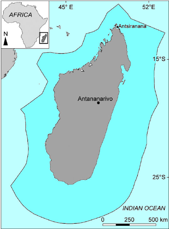
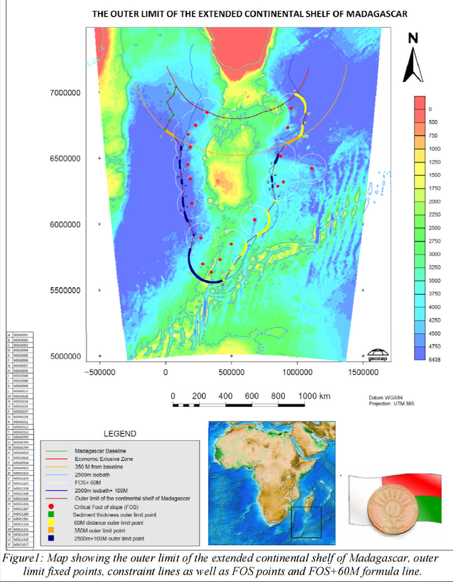
 Madagascar has a land area of 587,000 km2 and an Exclusive Economic Zone (EEZ) of 1.2 million km2. The officially announcement of the Malagasy continental shelf delineation project was made by means of the presidential decree n° 2003-660 of 4th June 2003 creating a National Committee for the delineation of the continental shelf. Nevertheless, it was only in 2007 that the restructured National Committee, according to the presidential decree n°2007-284 of 12th April, decided under the chairmanship of the Ministry of Foreign Affairs to plan the required activities for the delineation of the outer limit of the continental shelf beyond 200 M and for the preparation of the submission to the Commission on the Limits of the Continental Shelf. The Madagascar Plateau is regarded to form part of the submerged prolongation of the landmass of Madagascar, and consequently, to be part of the continental margin of Madagascar in accordance with paragraph 3 of article 76 of the Convention.
While climate change, overfishing and land use change negatively impact the biodiversity and ecological function of marine ecosystems worldwide, increasing evidence shows that effective conservation and management can recover the resource base, conserve biodiversity, and increase fisher's incomes. Yet targeting interventions to maximize returns across large regions remains a major challenge. The waters of the West Coast of Madagascar are home to 90% of Madagascar's coral reefs, large-scale export fisheries for shrimp, octopus, sea cucumbers, and tuna, and important artisanal fisheries. Nonetheless, the formal management of marine resources in the region is in its initial stages.
The inland fishery accounted for some 65% of the total domestic production inthe 1990s. The major lakes which account for the bulk of the fish produced are intensively fished, but most of the other takes are under-fished. The marine fishery consists of the artisanal and industrial sectors. The artisanal fishery is confined to the lagoons and the shallow coastal waters and accounts for most of the marine production. The inudstrial fishing fishery consists mainly of shrimp trawlers catching shrimp for the export market. The foreign vessels in Madagascar's EEZ were fishing mainly for tuna. The number of these vessels was increasing since tuna boats were moving from the East Central Atlantic (the West African coast).
Existing knowledge of the scale, composition and trends of Malagasy fisheries remains poor, and there is negligible information regarding unreported catches and illegal fishing in Madagascars waters. Small-scale fisheries, which are often substantial in developing countries such as Madagascar, are often unreported or underestimated.
Much of Madagascars pelagic environment remains unexploited by domestic fisheries, but several species of tuna (e.g., yellowfin Thunnus albacares, big-eye Thunnus obesus) are heavily targeted by illegal Asian and legal European fleets. Foreign fleets have been extensively present in Madagascars waters since at least the 1980s. These fleets target mainly tunalike species and sharks. Catches quickly growing to exactly 10,000 tonnes have been declared each year since 19862 by the European Union based on access agreements. However, actual catches are thought to be substantially underreported, and are more likely to have been around 18,000 t /yr. An Asian long-line fleet also operates in Malagasy waters, with unreported catches of up to 50,000 t/yr.
In Madagascar, the impacts of industrial tuna fishing are compounded by new offshore gas fields. West Africa, long the dominant region in Africa for oil exploration and production, may soon have competition from the rapidly developing new oil exploration frontier of East Africa. By 2004, US-based VANCO Energy, which specializes in state-of-the-art offshore drilling and exploration, was working off the east coast of Madagascar. Sub-Saharan Africa has unconventional oil potential, particularly heavy oil in Madagascar, with resources estimated to be 2 billion barrels. USGS also estimates that Madagascar has 16 billion barrels of conventional oil yet to be discovered. Overall, the scale of oil resources is not transformative in a global sense, but it has the potential to be important both for meeting domestic needs, which are currently very small, and providing a source of much-needed export revenue.
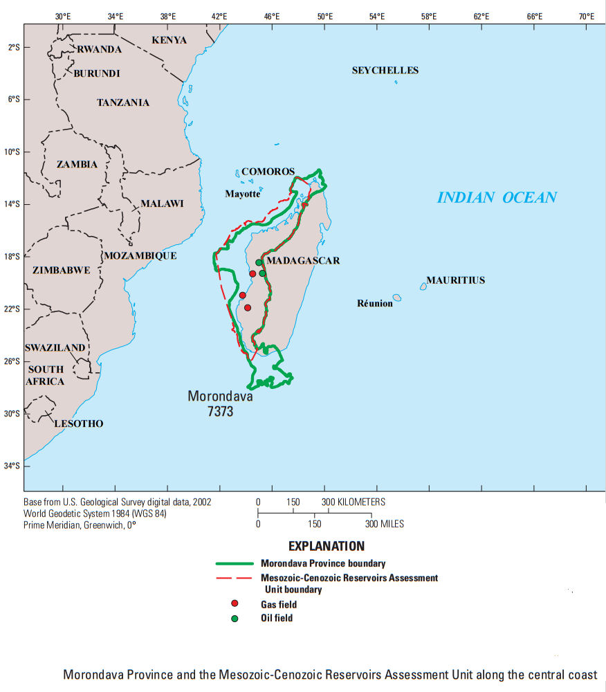
The Morondava Province is located along the western part of Madagascar, an area of approximately 460,690 square kilometers. The Morondava Province is characterized by rift, marginal-sag, passive-margin, and drift rocks of Paleozoic to Holocene age. The mean volumes are estimated at 10,750 million barrels of oil, 167,219 billion cubic feet of gas, and 5,176 million barrels of natural gas liquids. The estimated mean size of the largest oil field that is expected to be discovered is 1,016 million barrels of oil, and the estimated mean size of the expected largest gas field is 7,837 billion cubic feet of gas.
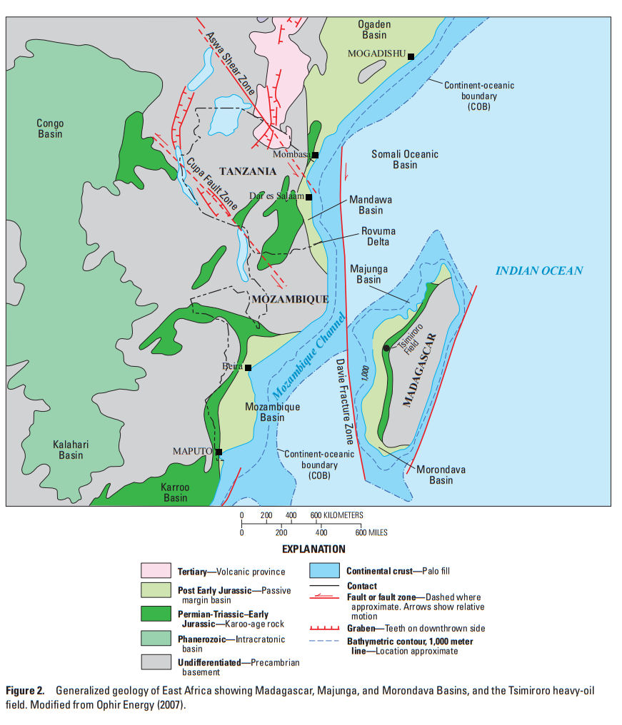
Oil and gas were generated from Permian to Jurassic Karoo-age lacustrine and continental source rocks (rift stage), from Early to Middle Jurassic restricted-marine rocks containing as much as 9 weight percent total organic carbon, and from Cretaceous Type II source rocks containing as much as 12 weight percent total organic carbon. Hydrocarbon generation most likely began in the latest Jurassic or earliest Cretaceous, and it continues today. Most generated hydrocarbons migrated into Cretaceous and Paleogene reservoirs and traps. Traps are mostly structural within the syn-rift rock units and both structural and stratigraphic in the post-rift rock units. The primary reservoir seals are Mesozoic and Cenozoic mudstone and shale.
|
NEWSLETTER
|
| Join the GlobalSecurity.org mailing list |
|
|
|