

| Chapter Three. Planning for Bulk-Fuel Distribution |
3-1. Introduction. Military forces require large quantities of petroleum products in support of combat operations. Special channels of responsibility for the supply of bulk-petroleum products, both in the continental United States (CONUS) and in overseas theater, have been established to ensure uninterrupted supply of these products. The Defense Logistics Agency (DLA) is responsible for the integrated management of bulk petroleum. (DLA works through the Defense Fuel Supply Center (DFSC).) DFSC procures and, with the military services and the Military Sealift Command (MSC), arranges for delivery of the products to the military services. DFSC contracts with a commercial supplier in CONUS or overseas and ensures that required fuel is shipped to the theater. Each of the military services has service control points that coordinate with DFSC on petroleum logistics matters. The US Army Petroleum Center performs this function for the Army worldwide.
3-2. Planning Organizations.
a. Joint Petroleum Office (JPO). The JPO, established by the Joint Chiefs of Staff, provides staff management of petroleum at the theater level on the staff of the unified commander. The JPO submits the monthly petroleum requirements of all the military services within the theater to the DFSC.
b. Theater Army. Theater army headquarters provides broad planning guidance for Army petroleum support. It supervises current operations and conducts long-range planning. The petroleum group, assigned to the theater army, is the major Army petroleum operator for the theater. When demand exceeds availability, the theater commander will establish an allocation system, based on priority, to support the theater plan of operations.
c. TAMMC. The TAMMC is the item manager for both bulk and packaged petroleum products. They collect long-range (annual) petroleum requirements for the theater that are based on the consumption data the petroleum staff officer and the petroleum group forward. The TAMMC submits petroleum requirements for the theater to the JPO.
d. Engineer Command (ENCOM). The ENCOM provides construction support for the petroleum facilities that are required to accomplish the theater support mission. The ENCOM plans and supervises construction or renovation of ports, roads, railways, petroleum pipelines, and petroleum-storage facilities in support of the bulk-fuel distribution system. General engineer construction units are augmented with specialized engineer units to accomplish the pipeline construction mission. The engineer units normally assigned to the ENCOM to construct petroleum facilities are the--
- Engineer construction group. This is a flexible organization designed to command up to five engineer battalions (or their equivalent) in assigned or attached troops.
- Combat heavy engineer battalion. This is the basic unit assigned to a specific pipeline construction mission. It is augmented with specialized units for equipment, expertise, and training support.
- Engineer pipeline construction support company. This company has limited, independent capabilities to construct pipeline systems.
- Engineer port construction company. This company provides specialized equipment and expertise for an engineer group for the construction and/or repair of waterfront structures.
The task organization of the engineer units for pipeline construction is based on mission, enemy, terrain, troops, and time available (METT-T). The engineer pipeline construction unit can provide technical advisors and equipment to three company-sized elements at a density of one squad per platoon on a 24-hour basis.
3-3. Port Support Operations. When pipeline materials arrive at the port of debarkation, they should be moved quickly from the port facility to the construction staging areas. If possible, the pipeline components, which require forklifts or cranes to be moved, should be transported directly from the ship-to-ground transporters. This will alleviate inefficient use of critical lifting and loading assets by eliminating double movement of the construction materials.
Pipeline materials are bulky and require a large staging area. Ten miles of pipeline components with one pumping station occupy an area about 100 yards by 50 yards. The staging area available at the port, the down-load rate (based on the rate of construction), and the ground-transportation rate need to be calculated so the port does not become clogged with pipeline components. The port-operations unit is responsible for down loading the pipeline components. Close coordination is required between the constructing engineer unit, the transportation unit tasked to move the components, and the port-operations unit responsible for down loading the materials.
3-4. Transportation Support Requirements. Moving pipeline construction materials to staging areas along the pipeline route is an equipment-intensive operation that is key to the success of the mission. Pipeline components either are stored in the US or are pre-positioned in the TO. They are packed for all methods of transportation. Based on theater requirements, transportation planners will determine the most effective method of moving pipeline components. The most common method is to use 40-foot flatbed trucks to and from shipping ports.
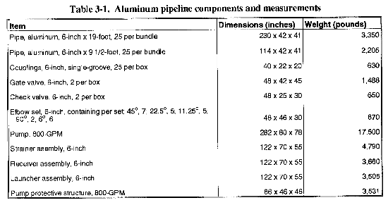
To transport 10 miles of 6-inch aluminum pipeline components, twenty-five 40-foot low-bed trailers are required. An aluminum-system mainline pumping station can be loaded on four 40-foot low-bed trailers. The extra material-handling equipment assigned to the pipeline construction support company must be allocated for loading and unloading the components. From the port of embarkation (sea) to the construction staging areas, the density of equipment support required is based on the rate of construction and the available port facilities. Table 3-1 is a list of the major aluminum pipeline system (IPDS) components with shipping dimensions and weights.
NOTE: The Sierra Army Depot stores the IPDS (TPT, pipe, couplings, and other hardware) containers (156 joints of pipe per International Standards Organization (ISO) container).
3-5. Construction Staging Areas. These areas are the transfer points of components from the 40-foot low-bed trailer to the bolster trailers and the 5-ton cargo trucks. Therefore, the location, size, and operation of the staging areas are key to the success of a pipeline-construction mission. Staging areas are located about every 10 miles along the proposed pipeline route. This reduces the turnaround time required to move the components from the construction staging areas to the construction site.
The mainline pumping unit, which requires a 20-ton crane (minimum) for loading, should be moved directly to the pump-station locations.
a. Considerations in Route Selection. The pipeline route is based on the petroleum supply and the demand locations that are assigned to the ENCOM by the theater army support command. The route will determine construction time, effort, and material requirements in either a positive or negative manner. The engineer pipeline construction support company has the expertise to determine the best pipeline route from source to demand. Construction equipment access, terrain, obstacles, and pipeline trace camouflage are the key factors in determining the best construction route. Topographic units have detailed topographic information that may help personnel evaluate an area and select the best route.
(1) Construction Equipment Access. A pipeline usually follows the most direct route possible from source to demand. After considering all the variables, the pipeline route is usually the route the campaign follows. However, the route should not run along the main supply route (MSR) because it is an important military target. The pipeline route should roughly parallel secondary roads. This will enable the construction crew to execute the stringing operation of pipeline construction as quickly as possible.
The stringing operation is the most labor-intensive and time-consuming activity in military pipeline construction. A pipeline is normally laid between 20 and 50 feet from the shoulder of the road. (An alternate route may be selected if it will save in the construction, patrol, operating-personnel, security, and maintenance areas.) Often, following the route that is cleared for power lines is best because power-line routes follow the most direct route (usually a straight line). However, access for vehicles during the stringing operations could be a problem, making the power-line route unusable. Using cross-country cutoffs can be beneficial where primary roads wind excessively and if the time and material savings are consistent with the extra construction and maintenance effort required.
(2) Terrain. The route chosen should be as level as possible, especially if it is an aluminum pipeline system. Unlevel terrain will require the use of sandbag leveling to limit joint deflection to two percent. A pipeline should be diverted around difficult terrain such as marshes, swamps, or land subject to periodic flooding.
(3) Obstacles. Obstacles can greatly increase the construction effort of a pipeline. The most common obstacle in pipeline construction is a road crossing. Existing culverts should be used whenever possible even if the pipeline must be diverted a short distance from its route. Any new road culverts that are required should be built before the pipeline reaches that culvert's location.
Culvert materials are provided in 5-mile sets of the new aluminum pipeline. Standard-weight commercial pipe can be used as culvert material, if available. The advantages to using standard-weight pipe are that it--
- Takes less soil for covering because the pipe has greater strength.
- Eliminates the need for the culvert to be constructed as with bolted culvert sections.
The disadvantage of using standard-weight pipe as a culvert is that additional transportation and placement are required.
(4) Camouflage. Based on threat type and level, the route selected should use as much natural cover and concealment as possible, if there is no substantial increase in construction effort. Natural cover includes fence lines, hedge rows, and tree lines. The natural state of the pipeline route should be left as undisturbed as possible. Grading and leveling the pipeline route is undesirable from a concealment standpoint but can greatly increase the rate of construction of a aluminum pipeline system. The trade off between camouflage and rate of construction must be weighed.
b. Procedure for Route Selection. The pipeline engineer (normally the company commander), assisted by the combat heavy engineer battalion Operations and Training Officer (US Army) (S3), uses the pipeline design criteria to start laying out the route location. Time permitting, location of the route proceeds as follows: aerial photographic studies, field reconnaissance, and route survey and route profile plotting. (Profiles should not be made from maps except in critical situations).
(1) Map and Aerial Photograph Studies. Studying maps may eliminate obviously unsuitable routes. A plastic relief map of the area, if obtainable, will assist in preliminary planning, Topographic maps of large scale, with contour intervals of 20 feet or less, give best results. Aerial photographic strip maps provide a check on roads, streams, and other terrain features that may not show up on maps. In choosing a tentative pipeline route by map study, the engineer takes into account--
- Accessibility of the route for stringing and placing equipment.
- Natural and man-made obstacles that will require additional construction effort and material.
- Suitable pump-station and construction-staging-area locations.
- Suitable petroleum-terminal locations.
- Accessibility for patrol and maintenance.
- Elevation and hydraulic grade line.
- Stream banks. Avoid these, especially if the stream habitually floods lowlands.
- Heavily populated areas. Avoid these areas because of the potential fire hazard that the pipeline presents.
(2) Field Reconnaissance. Routes tentatively selected by map study should be thoroughly inspected in the field.
(3) Air Reconnaissance. Air reconnaissance of all tentative routes frequently eliminates all but two or three possible routes. The helicopter's altimeter will give a rough approximation of the elevation along the route, Also, air reconnaissance can help evaluate the adequacy of natural cover along the proposed route.
(4) Ground Reconnaissance. Reconnaissance by foot and motor vehicle is used to confirm the decision as to which route is most suitable. A stadia survey of the selected route should be made, if possible. Ground distances are determined by chaining or by stadia measurement when the survey is run. Using a surveying altimeter helps determine fairly accurate elevation approximations along the route. Each altimeter traverse should be run in loops, ending the same day during hours of practically uniform temperature and stable air pressure. Speedometer mileage and pace counting will assist in approximating distance measurements.
c. Map Layout and Profile of Pipeline Route. Once the pipeline route is selected, it is laid out on a map. The combat heavy engineer battalion conducts a ground survey to plot a profile of the route. The scale of the profile should be as follows: vertical, 1 inch equals 200 feet; horizontal, 1 inch equals 2 miles. This profile is used to locate pumping stations, pressure-reducing stations, and other pipeline installations.
|
NEWSLETTER
|
| Join the GlobalSecurity.org mailing list |
|
|
|